Enable Location

We need your location to show you interesting places around you

Discover nearby places

Find interesting locations and hidden gems around you

Precise directions

Get accurate directions and distances to places

Your location is never shared with other users. It's only used when you tap the location button.

Clarendon School

Log in to your account

Start exploring — it's free

Trusted by 62,465 travelers worldwide

Continue with Google
Continue with Apple
or

We will send you a code to connect

By continuing, you accept our Terms and Conditions and our Privacy Policy

Check your inbox

We've sent a pincode in your inbox. Please enter the code below.

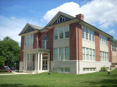
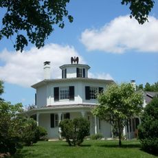
Clarendon School, historic school building in Arlington, Virginia, USA

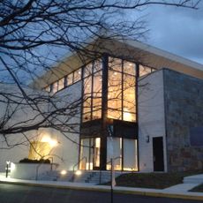
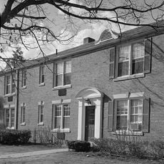
Clarendon School is a three-and-a-half-story brick building constructed in 1910 in Arlington, Virginia, designed in the Classical Revival style. The structure features large Palladian windows, limestone keystones above the openings, horizontal stone bands, and a formal entrance portico with Tuscan columns.

The school building was constructed in 1910 during Arlington's rapid growth as a suburb of the nation's capital and served as the only elementary school in the Clarendon area for over 60 years. After closing in 1973, it was converted into the Arlington Arts Center in 1977 and is now listed on the National Register of Historic Places.

The school is named after Matthew Maury, a Virginia native known for his work in navigation and mapmaking. The 1944 renaming reflects how the community honored influential local figures and valued their contributions to education and knowledge.

The building is located in the Ashton Heights Historic District and can often be viewed from nearby streets. Visitors should be respectful of the property and any access restrictions that may be in place.

The building was originally known as Clarendon School but was renamed Matthew Maury School in 1944, with many locals continuing to use its original name. The renaming honored a Virginian who was a cartographer, naval officer, and later a weather instructor at Virginia Military Institute.

The community of curious travelers

AroundUs brings together thousands of curated places, local tips, and hidden gems, enriched daily by 60,000 contributors worldwide.

Start exploring
Location
Architects
Charles M. Robinson
GPS coordinates
38.88170,-77.10220
Latest update
February 9, 2026 08:19
Around this place
Fort Myer
United States of America

Fort Myer

2 km
Confederate Memorial
United States of America

Confederate Memorial

2.2 km
Joint Base Myer–Henderson Hall
United States of America

Joint Base Myer–Henderson Hall

2 km
Arlington Hall
United States of America

Arlington Hall

1.6 km
Quarters 1
United States of America

Quarters 1

1.8 km
Columbia Gardens Cemetery
United States of America

Columbia Gardens Cemetery

1.3 km
Rough Riders Memorial
United States of America

Rough Riders Memorial

2.4 km
Unitarian Universalist Church of Arlington
United States of America

Unitarian Universalist Church of Arlington

1.6 km
Arlington Heights Historic District
United States of America

Arlington Heights Historic District

1.9 km
Fort C. F. Smith
United States of America

Fort C. F. Smith

2.4 km
Charles Richard Drew House
United States of America

Charles Richard Drew House

1.6 km
Glebe House
United States of America

Glebe House

1.8 km
Lyon Park Historic District
United States of America

Lyon Park Historic District

1 km
United States of America

Arlington Line

1.8 km
Bluemont Junction Trail
United States of America

Bluemont Junction Trail

2 km
Arlington Forest Historic District
United States of America

Arlington Forest Historic District

1.9 km
Maywood Historic District
United States of America

Maywood Historic District

1.8 km
Lee Gardens North Historic District
United States of America

Lee Gardens North Historic District

1.4 km
Fort Craig
United States of America

Fort Craig

2.2 km
Cherrydale Historic District
United States of America

Cherrydale Historic District

1.6 km
Calvert Manor
United States of America

Calvert Manor

1.7 km
Monroe Courts Historic District
United States of America

Monroe Courts Historic District

517 m
Fort Tillinghast
United States of America

Fort Tillinghast

1.6 km
Buckingham Historic District
United States of America

Buckingham Historic District

802 m
United States Post Office (Arlington, Virginia)
United States of America

United States Post Office (Arlington, Virginia)

718 m
Waverly Hills Historic District
United States of America

Waverly Hills Historic District

1.7 km
First Presbyterian Church
United States of America

First Presbyterian Church

1.1 km
Columbia Pike Library
United States of America

Columbia Pike Library

2.3 km
Show the full map
« Clarendon School - historic school building in Arlington, Virginia, USA » is provided by Around Us (aroundus.com). Images and texts are derived from Wikimedia project under a Creative Commons license. You are allowed to copy, distribute, and modify copies of this page, under the conditions set by the license, as long as this note is clearly visible.

Discover hidden gems everywhere you go!

From secret cafés to breathtaking viewpoints, skip the crowded tourist spots and find places that match your style. Our app makes it easy with voice search, smart filtering, route optimization, and insider tips from travelers worldwide. Download now for the complete mobile experience.

Around Us App Screenshot

A unique approach to discovering new places

Le Figaro

All the places worth exploring

France Info

A tailor-made excursion in just a few clicks

20 Minutes

Around Us
Travel Guide & Maps
Download

Send to your phone

QR Code
1

Open the camera app on your mobile.

2

Point at the QR code with your camera. A notification will appear.

3

Tap the notification to open the link.