See the monuments around you in AROpen chests in the app
Around Us is built for your phone — point your camera at the streets and discover the monuments and places around you in augmented reality.Around Us is built for your phone — chests unlock when you walk, explore and capture nearby places.
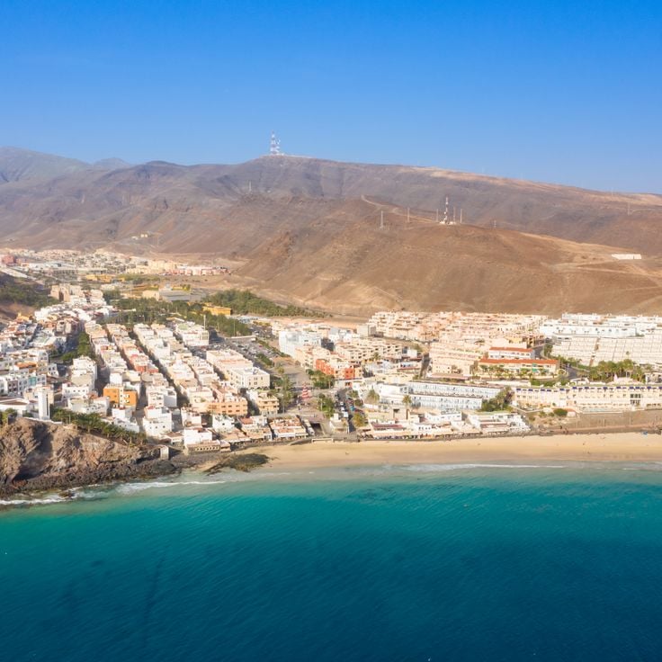
Visit Fuerteventura: natural parks, wild beaches and historical sites
Fuerteventura, the second largest island in the Canary Islands, is characterized by its diverse landscapes and notable geological features. The island houses spectacular formations such as the white dunes of Corralejo Natural Park, extending over more than 10 kilometers, the 70-million-year-old Ajuy caves, and accessible volcanoes like Calderon Hondo with its 70-meter-deep crater. The coastline offers expansive beaches like the one in Cofete, 12 kilometers long and backed by the Jandía mountains, as well as Lobos Island, a volcanic nature reserve with black sand beaches.
Beyond its natural assets, Fuerteventura offers cultural experiences such as the Grain Museum, which traces the island's agricultural history, and activities suitable for all ages with Oasis Park with 3,000 animals or Aqua Water Park in Corralejo. The island's climate allows visits year-round, with mild temperatures and ample sunshine promoting exploration of its natural parks, historical sites, and preserved coastline.
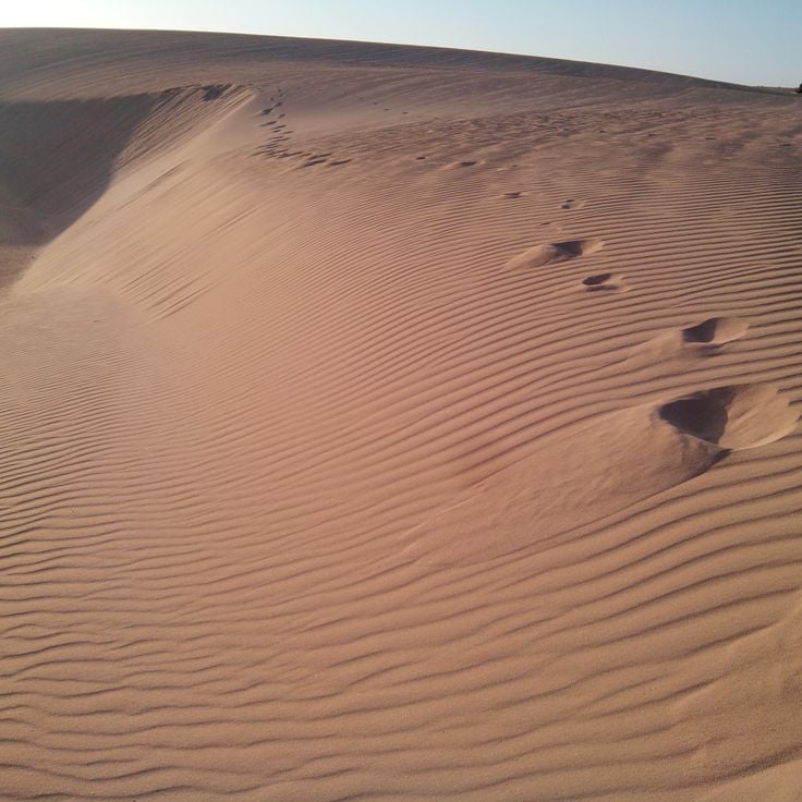
This natural park extends over an area of 2700 hectares on the northeast coast of Fuerteventura. The white sand dunes of the park stretch for more than 10 kilometers along the coastline and form one of the largest dune systems in the Canary Islands. The area is home to various endemic plant species adapted to the dry climate. The park's beaches provide direct access to the Atlantic Ocean with turquoise waters. Several hiking trails cross the dune area and allow visitors to explore the different landscape formations.
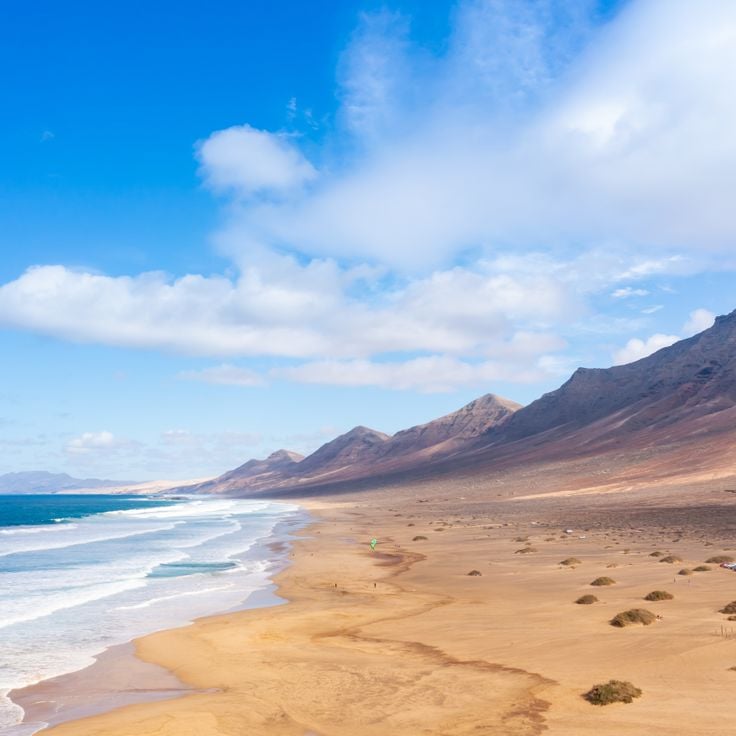
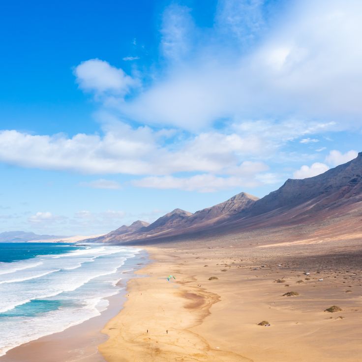
Cofete Beach extends for 12 kilometers along the Jandía mountains in southwestern Fuerteventura. This remote coastline is known for its powerful waves and strong currents that make swimming dangerous. An unpaved track leads through the nature reserve to this deserted beach without any tourist facilities. The access requires an off-road vehicle and takes about one hour from Morro Jable. The dark sand and rugged mountain slopes characterize the landscape of this western coast.
Oasis Park covers an area of 800,000 square metres in the south of Fuerteventura and houses more than 3,000 animals from 250 different species. The facility includes enclosures for giraffes, elephants, crocodiles, sea lions and numerous bird species. A botanical garden displays an extensive collection of cacti and succulent plants. The park offers daily shows featuring sea lions, birds of prey and parrots. Visitors can participate in camel rides through the grounds and observe various animal species during feeding sessions.
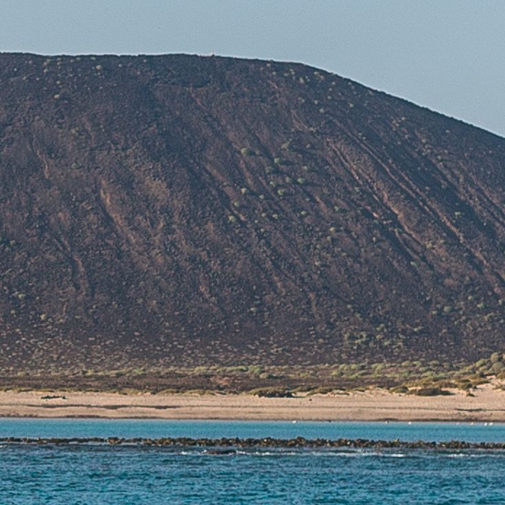
Lobos Island lies two kilometres north of Fuerteventura and forms a protected natural area covering 467 hectares. The territory includes several marked hiking trails that cross volcanic landscapes. The Punta Martiño lighthouse dates from 1865 and stands at the northern tip of the island. The beaches consist of dark volcanic sand. The area hosts numerous bird species and marine life. Access to the island is by boat from Corralejo, with daily visitor numbers limited to preserve the environment.
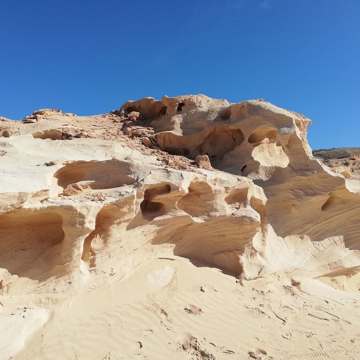
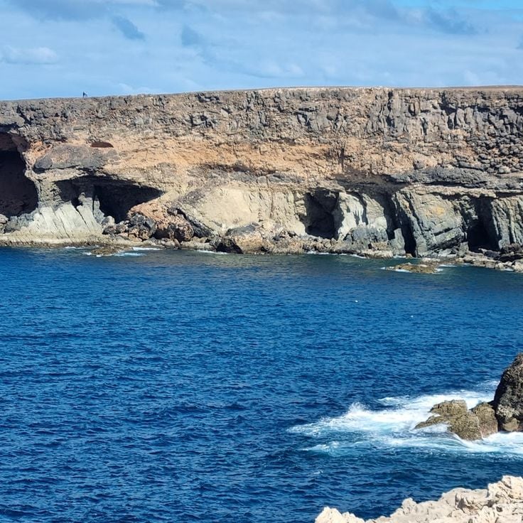
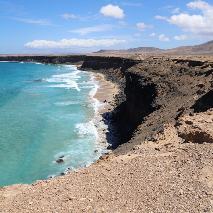
The Ajuy Caves are located on the western coast of Fuerteventura and represent some of the oldest geological formations in the Canary Islands. These natural cavities formed approximately 70 million years ago from submarine volcanic deposits. The black basalt cliffs rise directly above the Atlantic Ocean and provide insight into the island's geological history. A coastal path leads from the village of Ajuy to the caves, which can be viewed during the walk. The area held historical importance for lime extraction, used in the production of building materials.
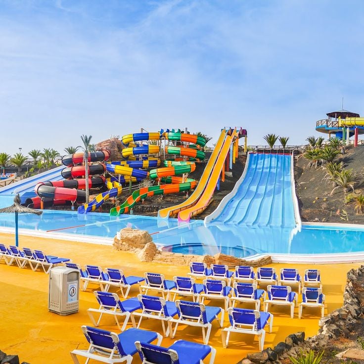
Acua Water Park is located in Corralejo in the north of Fuerteventura and features various water pools, slides and play areas for different age groups. The facility includes rest zones with sun loungers, dining establishments and changing rooms. Attractions include multiple water slides with varying difficulty levels, a wave pool and dedicated areas for younger children. Staff members monitor safety throughout all sections of the park.
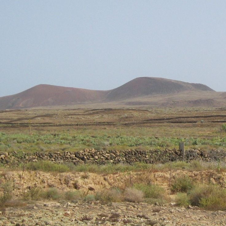
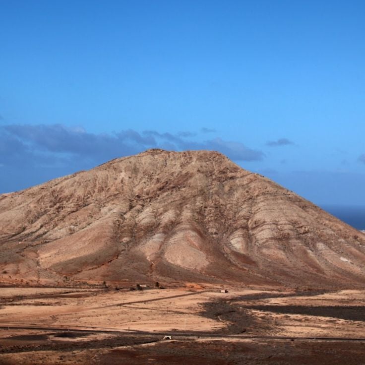
Calderon Hondo rises to 278 meters in the northern part of Fuerteventura. Its crater measures 70 meters in depth and provides a direct view into the island's volcanic structure. A marked hiking trail leads to the summit in approximately 30 minutes, offering views over the lava fields and the neighboring island of Lanzarote. The vegetation consists mainly of dry shrubs and lichens adapted to the arid climate.
The Entallada Lighthouse was built in 1953 and stands on a 200-meter cliff on the eastern coast of Fuerteventura. This red and white structure marks one of the key navigation points for maritime traffic between the African coast and the Canary Islands. The facility sits in a barren volcanic landscape and provides expansive views over the Atlantic Ocean. The lighthouse has served as a navigational beacon for over seventy years and can be viewed from the outside.
This natural park covers 14,000 hectares in southern Fuerteventura and includes the Jandía Peninsula mountain range, coastal sections and extensive sandy beaches. The protected area is home to several endemic plant species found only in the Canary Islands, as well as breeding colonies of protected seabirds. The mountain range reaches heights of over 800 meters and forms a natural barrier between the east and west coasts of the peninsula.
The Musée du Grain documents the history of grain cultivation on Fuerteventura. The exhibition displays agricultural tools, grinding stones, and equipment used in the processing of barley and wheat. The museum examines traditional farming methods adapted to the island's dry climate, as well as the importance of grain production for the local population over several centuries.
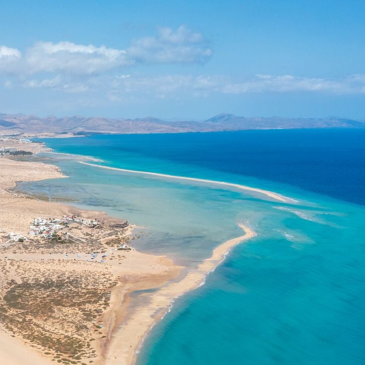
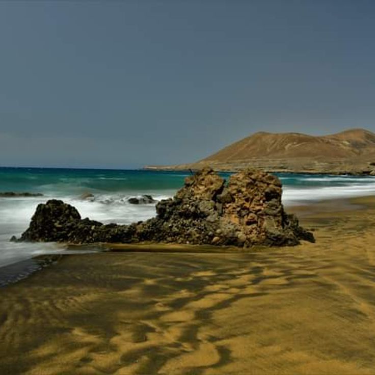
Sotavento Beach stretches for ten kilometers along the southern coast of Fuerteventura, offering fine white sand and a turquoise lagoon. The shallow waters and consistent winds make this location popular with kitesurfers and windsurfers. At low tide, an extensive sandbar forms, dividing the sea into two areas. The natural surroundings remain largely undeveloped, preserving the wild character of the coastline.
Santa Maria Cathedral was built in 1410 as the first religious building in the Canary Islands. It features an 18th-century baroque facade and houses three naves decorated with religious sculptures, including a carved altarpiece. The structure was rebuilt after pirate destruction in the 16th century and now serves as a museum of sacred art.
Castillo de El Tostón was built in 1743 on the northern coast of Fuerteventura. This circular fortification protected the fishing village of El Cotillo from pirate attacks originating from North Africa. The garrison monitored the coastline and alerted the population when danger approached. The tower features thick stone walls and cannon emplacements. Today, the fortress houses a museum dedicated to the history of fishing and coastal defenses in the Canary Islands.
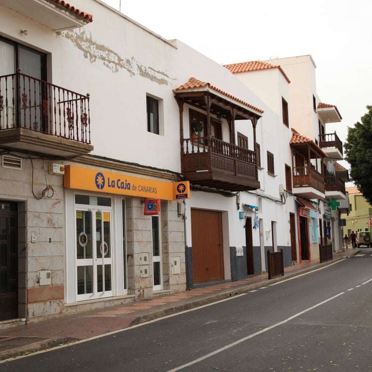
Puerto del Rosario serves as the capital and administrative center of Fuerteventura. The city developed around its commercial port, which handles trade with mainland Spain and other Canary Islands. The historic center displays traditional Canarian architecture with white houses featuring characteristic wooden balconies. Streets lead to the waterfront promenade, where shops, restaurants and public facilities are located. Puerto del Rosario hosts the island's international airport and serves as a starting point for visitors exploring Fuerteventura.
El Castillo Beach stretches along the Tostón Tower, an 18th-century military fortification. The fortress was built to protect the coastline from pirate raids. The golden sand beach offers direct views of this historical structure. The calm waters are suitable for swimming and bathing. The area combines natural beauty with military history. Visitors can explore the tower and discover the coastal landscape.
Montagne Tindaya rises in the north of Fuerteventura, reaching a height of 400 meters. This volcanic mountain is considered a sacred site by the Majos, the original inhabitants of the island. On its slopes, over 300 prehistoric engravings can be found, including numerous footprints believed to have been created during ritual ceremonies. The archaeological importance of this site makes it a significant testimony to the pre-Hispanic culture of the Canary Islands.
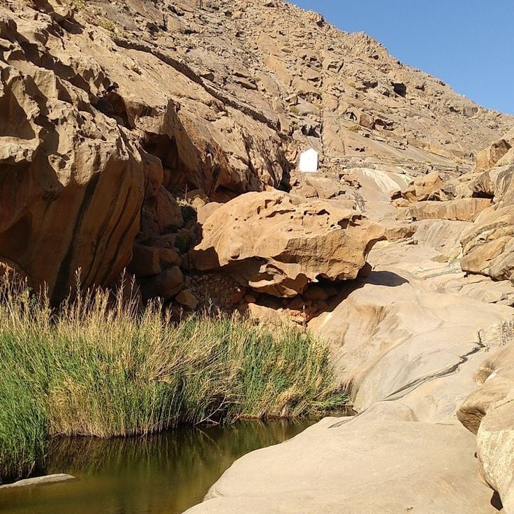
The Barranco de las Peñitas is a valley near Betancuria characterized by Canary Island date palms and steep rock walls. A small reservoir collects the scarce rainwater in this arid region of Fuerteventura. The hiking trail passes through the narrow gorge and provides insights into the island's vegetation and geology.
The village of Pájara sits in the interior of Fuerteventura and serves as the administrative center of the municipality. The 17th-century Church of Nuestra Señora de Regla dominates the historic core with its distinctive baroque façade featuring Aztec motifs. This decoration reflects the transatlantic connections during the colonial period. Narrow streets wind between whitewashed houses with traditional Canarian wooden balconies. The village provides access to hiking trails in the surrounding mountains and valleys of the region.
The Lagunas de El Cotillo form through natural reef formations that separate several ocean pools from the open Atlantic. These sheltered water basins feature white sandy bottoms and provide calm swimming conditions. The water remains clear and shallow due to the volcanic barriers. Located on the northwestern coast of Fuerteventura, the lagoon attracts visitors seeking tranquil waters for bathing. Tides refresh the water regularly through natural passages in the reef.
Morro Jable sits on the southern coast of Fuerteventura, combining its heritage as a fishing port with tourist development over recent decades. The town stretches along more than four kilometers of coastline, where Playa del Matorral and neighboring beaches offer fine golden sand. The center preserves elements of its maritime past, while hotels, restaurants, and shops line the seafront promenade. The harbor serves both commercial fishermen and ferry connections to neighboring islands. Its position at the base of the Jandía Peninsula provides access to hiking trails and protected natural areas inland.
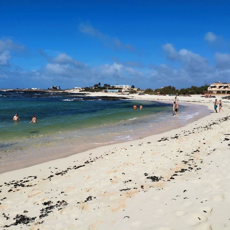
Playa del Matorral stretches for four kilometers along the southern coast of Fuerteventura. A white lighthouse stands at the eastern end, while the western section includes an area for naturists. The sea typically presents moderate waves. The fine sand and natural surroundings make this beach a popular destination for visitors seeking space and tranquility.
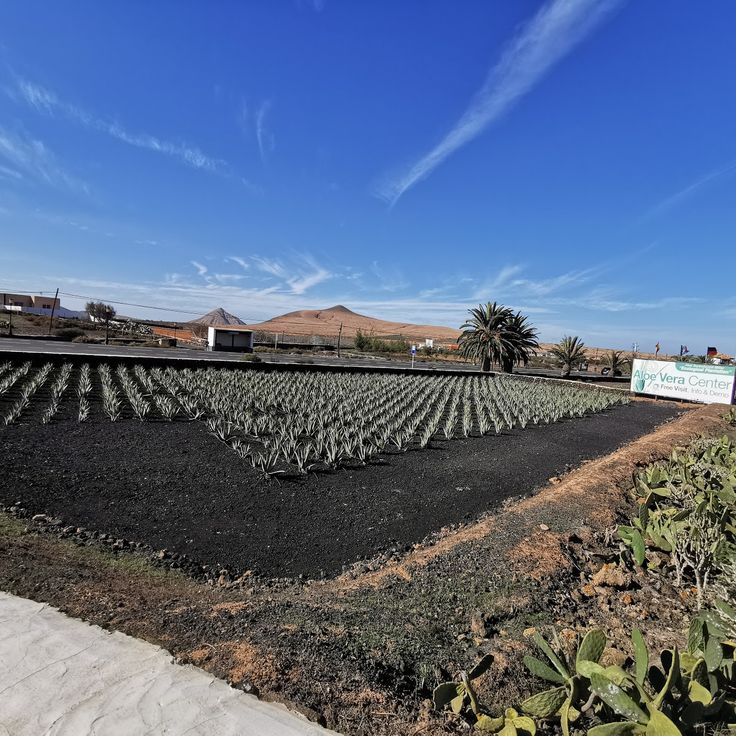
This aloe vera farm cultivates the succulent plant across terraced fields. Visitors receive explanations about growing methods and learn about the medicinal and cosmetic applications of the plant. The farm displays different growth stages of aloe vera and provides information about harvesting and processing the gel extracted from the fleshy leaves.
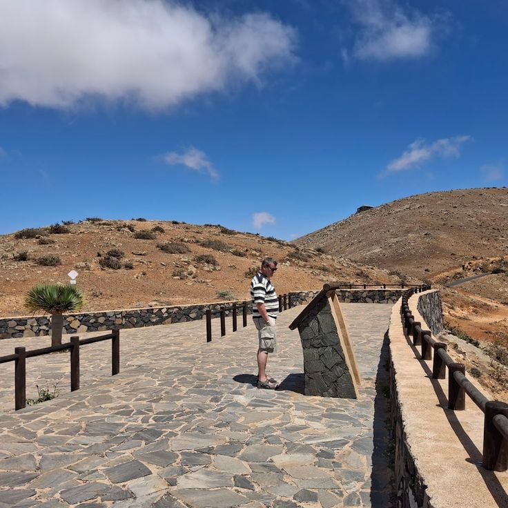
Mirador Morro Velosa stands at 669 meters elevation in the central mountain range of Fuerteventura. From its observation platform, visitors can view the volcanic peaks of Betancuria Natural Park, the agricultural plains, and the coastal areas to the north and east of the island. Designed by Canarian architects César Manrique and Jesús Soto, the building integrates into the natural surroundings and includes a restaurant and information panels about the geology and history of the region.
Los Oros Beach stretches for several hundred meters of golden sand south of Jandía. Volcanic rocks frame the coastline, creating natural boundaries with the surrounding terrain. An unpaved dirt path leads from the hinterland down to the shore. The sea regularly produces powerful waves that break along this exposed coast. Currents can be strong, particularly when winds blow from the west.
Plage del Águila stretches along the northwestern coast of Fuerteventura and offers a combination of golden sand and volcanic rock formations. Access is via a footpath starting from the village of El Cotillo. The Atlantic waves create consistent surf here, making this location a frequented surfing spot. The natural formation of black lava rocks contrasts with the light sand and frames the bay. The area belongs to a nature reserve and displays the typical volcanic landscape of the island.
The village of Majanicho sits on the northern coast of Fuerteventura and remains one of the island's less developed coastal settlements. White-painted houses line the shoreline with flat roofs and simple facades that exemplify traditional Canarian fishing architecture. The small natural harbor serves as a mooring point for local fishing boats, which take shelter in the protected bay during rough weather. The surrounding area features volcanic rock formations, and waves break directly against the black rocks along the shore. Majanicho has a few restaurants serving fresh fish and several holiday apartments for visitors seeking quiet accommodation away from the main tourist centers.
Los Molinos is a small fishing village on the west coast of Fuerteventura, situated between steep volcanic cliffs of red and black rock. The village maintains its traditional character with a few local restaurants serving fresh fish. The sheltered bay allows swimming when the sea is calm. Along the coast, several natural sea caves can be accessed at low tide. The surrounding area offers walking trails through the volcanic landscape with views over the Atlantic Ocean.
Villa Winter was built in the 1940s on a hill overlooking Cofete beach. The building features functional architecture with thick walls and few window openings. Its remote location on Fuerteventura's west coast and the austere design have led to numerous speculations about the original purpose of the house. The villa is named after its German builder Gustav Winter and sits amid a barren landscape overlooking the Atlantic Ocean.
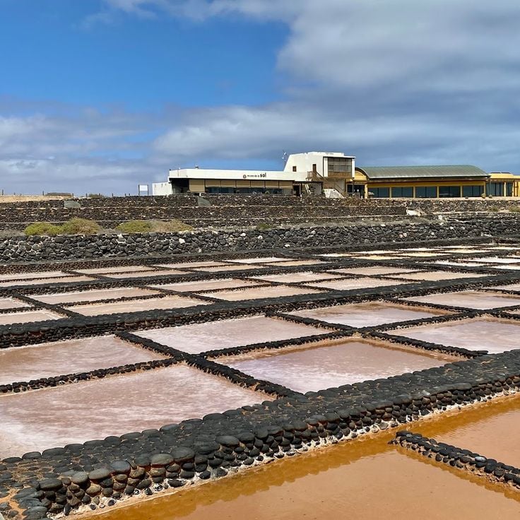
Las Salinas del Carmen is a former salt production facility that operated from the 18th century and now serves as a museum. The site demonstrates traditional sea salt production methods through evaporation in shallow ponds. Visitors can explore the restored salt basins and learn about the economic importance of this industry to Fuerteventura. The museum displays tools, photographs, and documents that illustrate the work of salt workers and the evolution of this activity over the centuries.
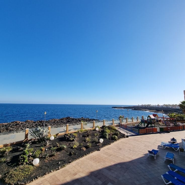
Caleta de Fuste is a coastal resort on the east coast of Fuerteventura featuring an artificial sandy beach protected by breakwaters. At low tide, natural pools form in the volcanic rocks, suitable for swimming. The bay provides calm waters and facilities for water sports. Along the promenade, there are restaurants, shops and hotels. The resort was developed as a tourist centre in the 1970s and includes a marina and golf courses in the surrounding area.
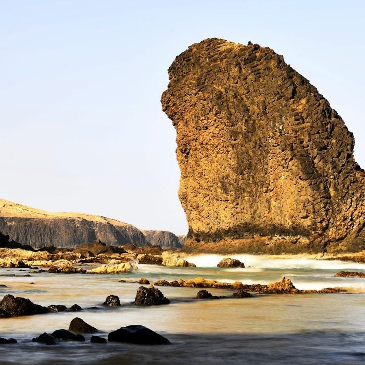
Roque del Moro rises as a dark basalt rock from the Atlantic Ocean, forming a distinctive geological feature along the coast of Fuerteventura. This natural monolith was created through volcanic activity and erosion over thousands of years. Fishermen and sailors have used the rock as a reference point for coastal navigation for centuries. The formation sits in an area characterized by strong waves and ocean currents. The black basalt creates a strong contrast against the blue waters of the ocean.
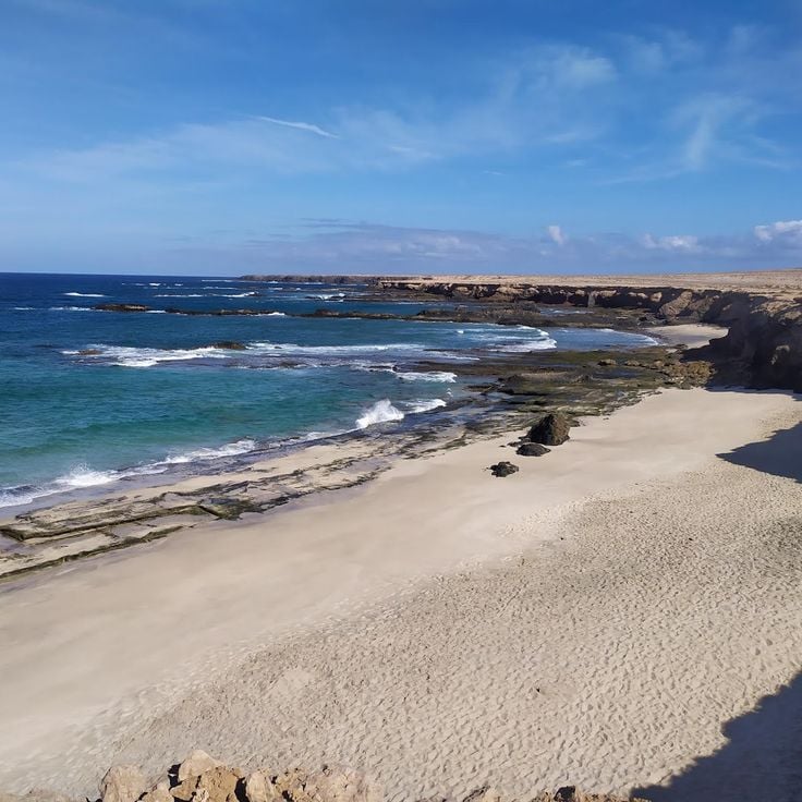
La Solapa Beach extends along the western coast of Fuerteventura, featuring fine light sand and clear waters. The cliffs behind the beach contain several caves formed by wave erosion. Narrow paths lead to various coves and access points along the coastline. The area lies away from main tourist zones and is reached via unpaved roads.
Barranco Encantado is a ravine system featuring walls of volcanic rock shaped by centuries of erosion. The geological formations clearly demonstrate Fuerteventura's volcanic origins and document the processes that created the island's present landscape.
This natural park extends over an area of 2700 hectares on the northeast coast of Fuerteventura. The white sand dunes of the park stretch for more than 10 kilometers along the coastline and form one of the largest dune systems in the Canary Islands. The area is home to various endemic plant species adapted to the dry climate. The park's beaches provide direct access to the Atlantic Ocean with turquoise waters. Several hiking trails cross the dune area and allow visitors to explore the different landscape formations.
Cofete Beach extends for 12 kilometers along the Jandía mountains in southwestern Fuerteventura. This remote coastline is known for its powerful waves and strong currents that make swimming dangerous. An unpaved track leads through the nature reserve to this deserted beach without any tourist facilities. The access requires an off-road vehicle and takes about one hour from Morro Jable. The dark sand and rugged mountain slopes characterize the landscape of this western coast.
Oasis Park covers an area of 800,000 square metres in the south of Fuerteventura and houses more than 3,000 animals from 250 different species. The facility includes enclosures for giraffes, elephants, crocodiles, sea lions and numerous bird species. A botanical garden displays an extensive collection of cacti and succulent plants. The park offers daily shows featuring sea lions, birds of prey and parrots. Visitors can participate in camel rides through the grounds and observe various animal species during feeding sessions.
Lobos Island lies two kilometres north of Fuerteventura and forms a protected natural area covering 467 hectares. The territory includes several marked hiking trails that cross volcanic landscapes. The Punta Martiño lighthouse dates from 1865 and stands at the northern tip of the island. The beaches consist of dark volcanic sand. The area hosts numerous bird species and marine life. Access to the island is by boat from Corralejo, with daily visitor numbers limited to preserve the environment.
The Ajuy Caves are located on the western coast of Fuerteventura and represent some of the oldest geological formations in the Canary Islands. These natural cavities formed approximately 70 million years ago from submarine volcanic deposits. The black basalt cliffs rise directly above the Atlantic Ocean and provide insight into the island's geological history. A coastal path leads from the village of Ajuy to the caves, which can be viewed during the walk. The area held historical importance for lime extraction, used in the production of building materials.
Acua Water Park is located in Corralejo in the north of Fuerteventura and features various water pools, slides and play areas for different age groups. The facility includes rest zones with sun loungers, dining establishments and changing rooms. Attractions include multiple water slides with varying difficulty levels, a wave pool and dedicated areas for younger children. Staff members monitor safety throughout all sections of the park.
Calderon Hondo rises to 278 meters in the northern part of Fuerteventura. Its crater measures 70 meters in depth and provides a direct view into the island's volcanic structure. A marked hiking trail leads to the summit in approximately 30 minutes, offering views over the lava fields and the neighboring island of Lanzarote. The vegetation consists mainly of dry shrubs and lichens adapted to the arid climate.
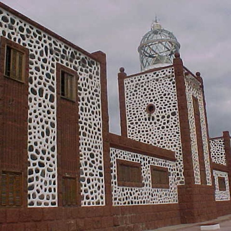
The Entallada Lighthouse was built in 1953 and stands on a 200-meter cliff on the eastern coast of Fuerteventura. This red and white structure marks one of the key navigation points for maritime traffic between the African coast and the Canary Islands. The facility sits in a barren volcanic landscape and provides expansive views over the Atlantic Ocean. The lighthouse has served as a navigational beacon for over seventy years and can be viewed from the outside.
This natural park covers 14,000 hectares in southern Fuerteventura and includes the Jandía Peninsula mountain range, coastal sections and extensive sandy beaches. The protected area is home to several endemic plant species found only in the Canary Islands, as well as breeding colonies of protected seabirds. The mountain range reaches heights of over 800 meters and forms a natural barrier between the east and west coasts of the peninsula.
The Musée du Grain documents the history of grain cultivation on Fuerteventura. The exhibition displays agricultural tools, grinding stones, and equipment used in the processing of barley and wheat. The museum examines traditional farming methods adapted to the island's dry climate, as well as the importance of grain production for the local population over several centuries.
Sotavento Beach stretches for ten kilometers along the southern coast of Fuerteventura, offering fine white sand and a turquoise lagoon. The shallow waters and consistent winds make this location popular with kitesurfers and windsurfers. At low tide, an extensive sandbar forms, dividing the sea into two areas. The natural surroundings remain largely undeveloped, preserving the wild character of the coastline.
Santa Maria Cathedral was built in 1410 as the first religious building in the Canary Islands. It features an 18th-century baroque facade and houses three naves decorated with religious sculptures, including a carved altarpiece. The structure was rebuilt after pirate destruction in the 16th century and now serves as a museum of sacred art.
Castillo de El Tostón was built in 1743 on the northern coast of Fuerteventura. This circular fortification protected the fishing village of El Cotillo from pirate attacks originating from North Africa. The garrison monitored the coastline and alerted the population when danger approached. The tower features thick stone walls and cannon emplacements. Today, the fortress houses a museum dedicated to the history of fishing and coastal defenses in the Canary Islands.
Puerto del Rosario serves as the capital and administrative center of Fuerteventura. The city developed around its commercial port, which handles trade with mainland Spain and other Canary Islands. The historic center displays traditional Canarian architecture with white houses featuring characteristic wooden balconies. Streets lead to the waterfront promenade, where shops, restaurants and public facilities are located. Puerto del Rosario hosts the island's international airport and serves as a starting point for visitors exploring Fuerteventura.
El Castillo Beach stretches along the Tostón Tower, an 18th-century military fortification. The fortress was built to protect the coastline from pirate raids. The golden sand beach offers direct views of this historical structure. The calm waters are suitable for swimming and bathing. The area combines natural beauty with military history. Visitors can explore the tower and discover the coastal landscape.
Montagne Tindaya rises in the north of Fuerteventura, reaching a height of 400 meters. This volcanic mountain is considered a sacred site by the Majos, the original inhabitants of the island. On its slopes, over 300 prehistoric engravings can be found, including numerous footprints believed to have been created during ritual ceremonies. The archaeological importance of this site makes it a significant testimony to the pre-Hispanic culture of the Canary Islands.
The Barranco de las Peñitas is a valley near Betancuria characterized by Canary Island date palms and steep rock walls. A small reservoir collects the scarce rainwater in this arid region of Fuerteventura. The hiking trail passes through the narrow gorge and provides insights into the island's vegetation and geology.
The village of Pájara sits in the interior of Fuerteventura and serves as the administrative center of the municipality. The 17th-century Church of Nuestra Señora de Regla dominates the historic core with its distinctive baroque façade featuring Aztec motifs. This decoration reflects the transatlantic connections during the colonial period. Narrow streets wind between whitewashed houses with traditional Canarian wooden balconies. The village provides access to hiking trails in the surrounding mountains and valleys of the region.
The Lagunas de El Cotillo form through natural reef formations that separate several ocean pools from the open Atlantic. These sheltered water basins feature white sandy bottoms and provide calm swimming conditions. The water remains clear and shallow due to the volcanic barriers. Located on the northwestern coast of Fuerteventura, the lagoon attracts visitors seeking tranquil waters for bathing. Tides refresh the water regularly through natural passages in the reef.
Morro Jable sits on the southern coast of Fuerteventura, combining its heritage as a fishing port with tourist development over recent decades. The town stretches along more than four kilometers of coastline, where Playa del Matorral and neighboring beaches offer fine golden sand. The center preserves elements of its maritime past, while hotels, restaurants, and shops line the seafront promenade. The harbor serves both commercial fishermen and ferry connections to neighboring islands. Its position at the base of the Jandía Peninsula provides access to hiking trails and protected natural areas inland.
Playa del Matorral stretches for four kilometers along the southern coast of Fuerteventura. A white lighthouse stands at the eastern end, while the western section includes an area for naturists. The sea typically presents moderate waves. The fine sand and natural surroundings make this beach a popular destination for visitors seeking space and tranquility.
This aloe vera farm cultivates the succulent plant across terraced fields. Visitors receive explanations about growing methods and learn about the medicinal and cosmetic applications of the plant. The farm displays different growth stages of aloe vera and provides information about harvesting and processing the gel extracted from the fleshy leaves.
Mirador Morro Velosa stands at 669 meters elevation in the central mountain range of Fuerteventura. From its observation platform, visitors can view the volcanic peaks of Betancuria Natural Park, the agricultural plains, and the coastal areas to the north and east of the island. Designed by Canarian architects César Manrique and Jesús Soto, the building integrates into the natural surroundings and includes a restaurant and information panels about the geology and history of the region.
Los Oros Beach stretches for several hundred meters of golden sand south of Jandía. Volcanic rocks frame the coastline, creating natural boundaries with the surrounding terrain. An unpaved dirt path leads from the hinterland down to the shore. The sea regularly produces powerful waves that break along this exposed coast. Currents can be strong, particularly when winds blow from the west.
Plage del Águila stretches along the northwestern coast of Fuerteventura and offers a combination of golden sand and volcanic rock formations. Access is via a footpath starting from the village of El Cotillo. The Atlantic waves create consistent surf here, making this location a frequented surfing spot. The natural formation of black lava rocks contrasts with the light sand and frames the bay. The area belongs to a nature reserve and displays the typical volcanic landscape of the island.
The village of Majanicho sits on the northern coast of Fuerteventura and remains one of the island's less developed coastal settlements. White-painted houses line the shoreline with flat roofs and simple facades that exemplify traditional Canarian fishing architecture. The small natural harbor serves as a mooring point for local fishing boats, which take shelter in the protected bay during rough weather. The surrounding area features volcanic rock formations, and waves break directly against the black rocks along the shore. Majanicho has a few restaurants serving fresh fish and several holiday apartments for visitors seeking quiet accommodation away from the main tourist centers.
Los Molinos is a small fishing village on the west coast of Fuerteventura, situated between steep volcanic cliffs of red and black rock. The village maintains its traditional character with a few local restaurants serving fresh fish. The sheltered bay allows swimming when the sea is calm. Along the coast, several natural sea caves can be accessed at low tide. The surrounding area offers walking trails through the volcanic landscape with views over the Atlantic Ocean.
Villa Winter was built in the 1940s on a hill overlooking Cofete beach. The building features functional architecture with thick walls and few window openings. Its remote location on Fuerteventura's west coast and the austere design have led to numerous speculations about the original purpose of the house. The villa is named after its German builder Gustav Winter and sits amid a barren landscape overlooking the Atlantic Ocean.
Las Salinas del Carmen is a former salt production facility that operated from the 18th century and now serves as a museum. The site demonstrates traditional sea salt production methods through evaporation in shallow ponds. Visitors can explore the restored salt basins and learn about the economic importance of this industry to Fuerteventura. The museum displays tools, photographs, and documents that illustrate the work of salt workers and the evolution of this activity over the centuries.
Caleta de Fuste is a coastal resort on the east coast of Fuerteventura featuring an artificial sandy beach protected by breakwaters. At low tide, natural pools form in the volcanic rocks, suitable for swimming. The bay provides calm waters and facilities for water sports. Along the promenade, there are restaurants, shops and hotels. The resort was developed as a tourist centre in the 1970s and includes a marina and golf courses in the surrounding area.
Roque del Moro rises as a dark basalt rock from the Atlantic Ocean, forming a distinctive geological feature along the coast of Fuerteventura. This natural monolith was created through volcanic activity and erosion over thousands of years. Fishermen and sailors have used the rock as a reference point for coastal navigation for centuries. The formation sits in an area characterized by strong waves and ocean currents. The black basalt creates a strong contrast against the blue waters of the ocean.
La Solapa Beach extends along the western coast of Fuerteventura, featuring fine light sand and clear waters. The cliffs behind the beach contain several caves formed by wave erosion. Narrow paths lead to various coves and access points along the coastline. The area lies away from main tourist zones and is reached via unpaved roads.
Barranco Encantado is a ravine system featuring walls of volcanic rock shaped by centuries of erosion. The geological formations clearly demonstrate Fuerteventura's volcanic origins and document the processes that created the island's present landscape.
This natural park extends over an area of 2700 hectares on the northeast coast of Fuerteventura. The white sand dunes of the park stretch for more than 10 kilometers along the coastline and form one of the largest dune systems in the Canary Islands. The area is home to various endemic plant species adapted to the dry climate. The park's beaches provide direct access to the Atlantic Ocean with turquoise waters. Several hiking trails cross the dune area and allow visitors to explore the different landscape formations.
Cofete Beach extends for 12 kilometers along the Jandía mountains in southwestern Fuerteventura. This remote coastline is known for its powerful waves and strong currents that make swimming dangerous. An unpaved track leads through the nature reserve to this deserted beach without any tourist facilities. The access requires an off-road vehicle and takes about one hour from Morro Jable. The dark sand and rugged mountain slopes characterize the landscape of this western coast.
Oasis Park covers an area of 800,000 square metres in the south of Fuerteventura and houses more than 3,000 animals from 250 different species. The facility includes enclosures for giraffes, elephants, crocodiles, sea lions and numerous bird species. A botanical garden displays an extensive collection of cacti and succulent plants. The park offers daily shows featuring sea lions, birds of prey and parrots. Visitors can participate in camel rides through the grounds and observe various animal species during feeding sessions.
Lobos Island lies two kilometres north of Fuerteventura and forms a protected natural area covering 467 hectares. The territory includes several marked hiking trails that cross volcanic landscapes. The Punta Martiño lighthouse dates from 1865 and stands at the northern tip of the island. The beaches consist of dark volcanic sand. The area hosts numerous bird species and marine life. Access to the island is by boat from Corralejo, with daily visitor numbers limited to preserve the environment.
The Ajuy Caves are located on the western coast of Fuerteventura and represent some of the oldest geological formations in the Canary Islands. These natural cavities formed approximately 70 million years ago from submarine volcanic deposits. The black basalt cliffs rise directly above the Atlantic Ocean and provide insight into the island's geological history. A coastal path leads from the village of Ajuy to the caves, which can be viewed during the walk. The area held historical importance for lime extraction, used in the production of building materials.
Acua Water Park is located in Corralejo in the north of Fuerteventura and features various water pools, slides and play areas for different age groups. The facility includes rest zones with sun loungers, dining establishments and changing rooms. Attractions include multiple water slides with varying difficulty levels, a wave pool and dedicated areas for younger children. Staff members monitor safety throughout all sections of the park.
Calderon Hondo rises to 278 meters in the northern part of Fuerteventura. Its crater measures 70 meters in depth and provides a direct view into the island's volcanic structure. A marked hiking trail leads to the summit in approximately 30 minutes, offering views over the lava fields and the neighboring island of Lanzarote. The vegetation consists mainly of dry shrubs and lichens adapted to the arid climate.
The Entallada Lighthouse was built in 1953 and stands on a 200-meter cliff on the eastern coast of Fuerteventura. This red and white structure marks one of the key navigation points for maritime traffic between the African coast and the Canary Islands. The facility sits in a barren volcanic landscape and provides expansive views over the Atlantic Ocean. The lighthouse has served as a navigational beacon for over seventy years and can be viewed from the outside.
This natural park covers 14,000 hectares in southern Fuerteventura and includes the Jandía Peninsula mountain range, coastal sections and extensive sandy beaches. The protected area is home to several endemic plant species found only in the Canary Islands, as well as breeding colonies of protected seabirds. The mountain range reaches heights of over 800 meters and forms a natural barrier between the east and west coasts of the peninsula.
The Musée du Grain documents the history of grain cultivation on Fuerteventura. The exhibition displays agricultural tools, grinding stones, and equipment used in the processing of barley and wheat. The museum examines traditional farming methods adapted to the island's dry climate, as well as the importance of grain production for the local population over several centuries.
Sotavento Beach stretches for ten kilometers along the southern coast of Fuerteventura, offering fine white sand and a turquoise lagoon. The shallow waters and consistent winds make this location popular with kitesurfers and windsurfers. At low tide, an extensive sandbar forms, dividing the sea into two areas. The natural surroundings remain largely undeveloped, preserving the wild character of the coastline.
Santa Maria Cathedral was built in 1410 as the first religious building in the Canary Islands. It features an 18th-century baroque facade and houses three naves decorated with religious sculptures, including a carved altarpiece. The structure was rebuilt after pirate destruction in the 16th century and now serves as a museum of sacred art.
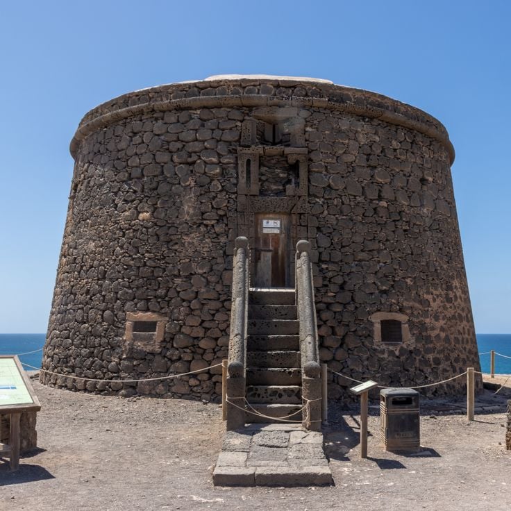
Castillo de El Tostón was built in 1743 on the northern coast of Fuerteventura. This circular fortification protected the fishing village of El Cotillo from pirate attacks originating from North Africa. The garrison monitored the coastline and alerted the population when danger approached. The tower features thick stone walls and cannon emplacements. Today, the fortress houses a museum dedicated to the history of fishing and coastal defenses in the Canary Islands.
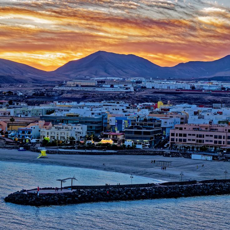
Puerto del Rosario serves as the capital and administrative center of Fuerteventura. The city developed around its commercial port, which handles trade with mainland Spain and other Canary Islands. The historic center displays traditional Canarian architecture with white houses featuring characteristic wooden balconies. Streets lead to the waterfront promenade, where shops, restaurants and public facilities are located. Puerto del Rosario hosts the island's international airport and serves as a starting point for visitors exploring Fuerteventura.
El Castillo Beach stretches along the Tostón Tower, an 18th-century military fortification. The fortress was built to protect the coastline from pirate raids. The golden sand beach offers direct views of this historical structure. The calm waters are suitable for swimming and bathing. The area combines natural beauty with military history. Visitors can explore the tower and discover the coastal landscape.
Montagne Tindaya rises in the north of Fuerteventura, reaching a height of 400 meters. This volcanic mountain is considered a sacred site by the Majos, the original inhabitants of the island. On its slopes, over 300 prehistoric engravings can be found, including numerous footprints believed to have been created during ritual ceremonies. The archaeological importance of this site makes it a significant testimony to the pre-Hispanic culture of the Canary Islands.
The Barranco de las Peñitas is a valley near Betancuria characterized by Canary Island date palms and steep rock walls. A small reservoir collects the scarce rainwater in this arid region of Fuerteventura. The hiking trail passes through the narrow gorge and provides insights into the island's vegetation and geology.
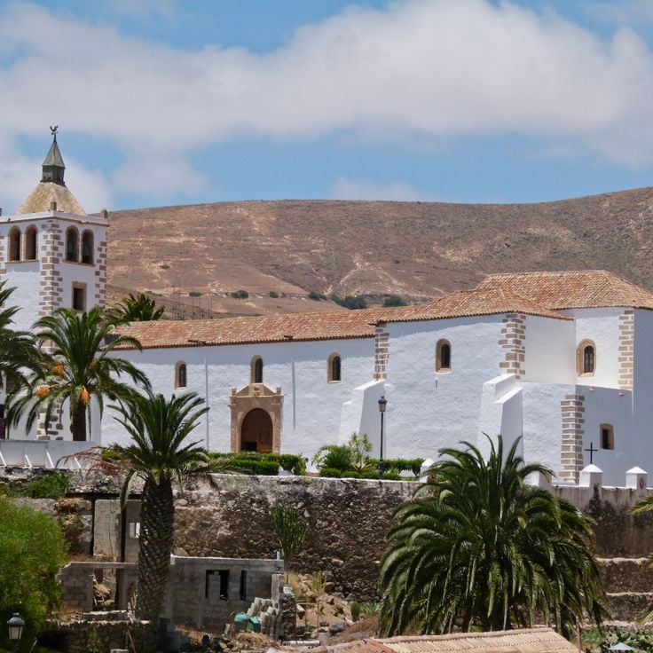
The village of Pájara sits in the interior of Fuerteventura and serves as the administrative center of the municipality. The 17th-century Church of Nuestra Señora de Regla dominates the historic core with its distinctive baroque façade featuring Aztec motifs. This decoration reflects the transatlantic connections during the colonial period. Narrow streets wind between whitewashed houses with traditional Canarian wooden balconies. The village provides access to hiking trails in the surrounding mountains and valleys of the region.
The Lagunas de El Cotillo form through natural reef formations that separate several ocean pools from the open Atlantic. These sheltered water basins feature white sandy bottoms and provide calm swimming conditions. The water remains clear and shallow due to the volcanic barriers. Located on the northwestern coast of Fuerteventura, the lagoon attracts visitors seeking tranquil waters for bathing. Tides refresh the water regularly through natural passages in the reef.
Morro Jable sits on the southern coast of Fuerteventura, combining its heritage as a fishing port with tourist development over recent decades. The town stretches along more than four kilometers of coastline, where Playa del Matorral and neighboring beaches offer fine golden sand. The center preserves elements of its maritime past, while hotels, restaurants, and shops line the seafront promenade. The harbor serves both commercial fishermen and ferry connections to neighboring islands. Its position at the base of the Jandía Peninsula provides access to hiking trails and protected natural areas inland.
Playa del Matorral stretches for four kilometers along the southern coast of Fuerteventura. A white lighthouse stands at the eastern end, while the western section includes an area for naturists. The sea typically presents moderate waves. The fine sand and natural surroundings make this beach a popular destination for visitors seeking space and tranquility.
This aloe vera farm cultivates the succulent plant across terraced fields. Visitors receive explanations about growing methods and learn about the medicinal and cosmetic applications of the plant. The farm displays different growth stages of aloe vera and provides information about harvesting and processing the gel extracted from the fleshy leaves.
Mirador Morro Velosa stands at 669 meters elevation in the central mountain range of Fuerteventura. From its observation platform, visitors can view the volcanic peaks of Betancuria Natural Park, the agricultural plains, and the coastal areas to the north and east of the island. Designed by Canarian architects César Manrique and Jesús Soto, the building integrates into the natural surroundings and includes a restaurant and information panels about the geology and history of the region.
Los Oros Beach stretches for several hundred meters of golden sand south of Jandía. Volcanic rocks frame the coastline, creating natural boundaries with the surrounding terrain. An unpaved dirt path leads from the hinterland down to the shore. The sea regularly produces powerful waves that break along this exposed coast. Currents can be strong, particularly when winds blow from the west.
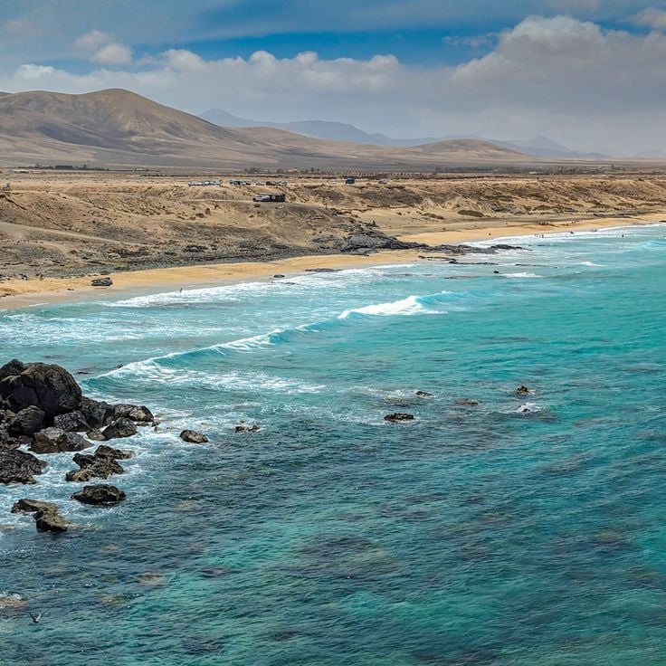
Plage del Águila stretches along the northwestern coast of Fuerteventura and offers a combination of golden sand and volcanic rock formations. Access is via a footpath starting from the village of El Cotillo. The Atlantic waves create consistent surf here, making this location a frequented surfing spot. The natural formation of black lava rocks contrasts with the light sand and frames the bay. The area belongs to a nature reserve and displays the typical volcanic landscape of the island.
The village of Majanicho sits on the northern coast of Fuerteventura and remains one of the island's less developed coastal settlements. White-painted houses line the shoreline with flat roofs and simple facades that exemplify traditional Canarian fishing architecture. The small natural harbor serves as a mooring point for local fishing boats, which take shelter in the protected bay during rough weather. The surrounding area features volcanic rock formations, and waves break directly against the black rocks along the shore. Majanicho has a few restaurants serving fresh fish and several holiday apartments for visitors seeking quiet accommodation away from the main tourist centers.
Los Molinos is a small fishing village on the west coast of Fuerteventura, situated between steep volcanic cliffs of red and black rock. The village maintains its traditional character with a few local restaurants serving fresh fish. The sheltered bay allows swimming when the sea is calm. Along the coast, several natural sea caves can be accessed at low tide. The surrounding area offers walking trails through the volcanic landscape with views over the Atlantic Ocean.
Villa Winter was built in the 1940s on a hill overlooking Cofete beach. The building features functional architecture with thick walls and few window openings. Its remote location on Fuerteventura's west coast and the austere design have led to numerous speculations about the original purpose of the house. The villa is named after its German builder Gustav Winter and sits amid a barren landscape overlooking the Atlantic Ocean.
Las Salinas del Carmen is a former salt production facility that operated from the 18th century and now serves as a museum. The site demonstrates traditional sea salt production methods through evaporation in shallow ponds. Visitors can explore the restored salt basins and learn about the economic importance of this industry to Fuerteventura. The museum displays tools, photographs, and documents that illustrate the work of salt workers and the evolution of this activity over the centuries.
Caleta de Fuste is a coastal resort on the east coast of Fuerteventura featuring an artificial sandy beach protected by breakwaters. At low tide, natural pools form in the volcanic rocks, suitable for swimming. The bay provides calm waters and facilities for water sports. Along the promenade, there are restaurants, shops and hotels. The resort was developed as a tourist centre in the 1970s and includes a marina and golf courses in the surrounding area.
Roque del Moro rises as a dark basalt rock from the Atlantic Ocean, forming a distinctive geological feature along the coast of Fuerteventura. This natural monolith was created through volcanic activity and erosion over thousands of years. Fishermen and sailors have used the rock as a reference point for coastal navigation for centuries. The formation sits in an area characterized by strong waves and ocean currents. The black basalt creates a strong contrast against the blue waters of the ocean.
La Solapa Beach extends along the western coast of Fuerteventura, featuring fine light sand and clear waters. The cliffs behind the beach contain several caves formed by wave erosion. Narrow paths lead to various coves and access points along the coastline. The area lies away from main tourist zones and is reached via unpaved roads.
Barranco Encantado is a ravine system featuring walls of volcanic rock shaped by centuries of erosion. The geological formations clearly demonstrate Fuerteventura's volcanic origins and document the processes that created the island's present landscape.