Alpine sites in Switzerland: mountains, lakes, and valleys
The Swiss Alps include peaks, valleys, lakes, and passes that have impressed travelers for a long time. This collection brings together places where nature shows its best side: the Matterhorn with its recognizable shape, the green waters of the Verzasca Valley, the Gornergrat view facing 29 peaks, and the St. Moritz lake that becomes a natural ice rink in winter.
Alongside these natural sights, you will also see signs of local craftsmanship, like dams hanging on the rocky walls, funiculars and cogwheel trains that have climbed higher for more than a century, or cultural sites such as the Pierre Gianadda Foundation in Martigny. Each place tells in its own way how the Swiss tamed their mountains while respecting them. A journey between high altitude and a gentle way of life.
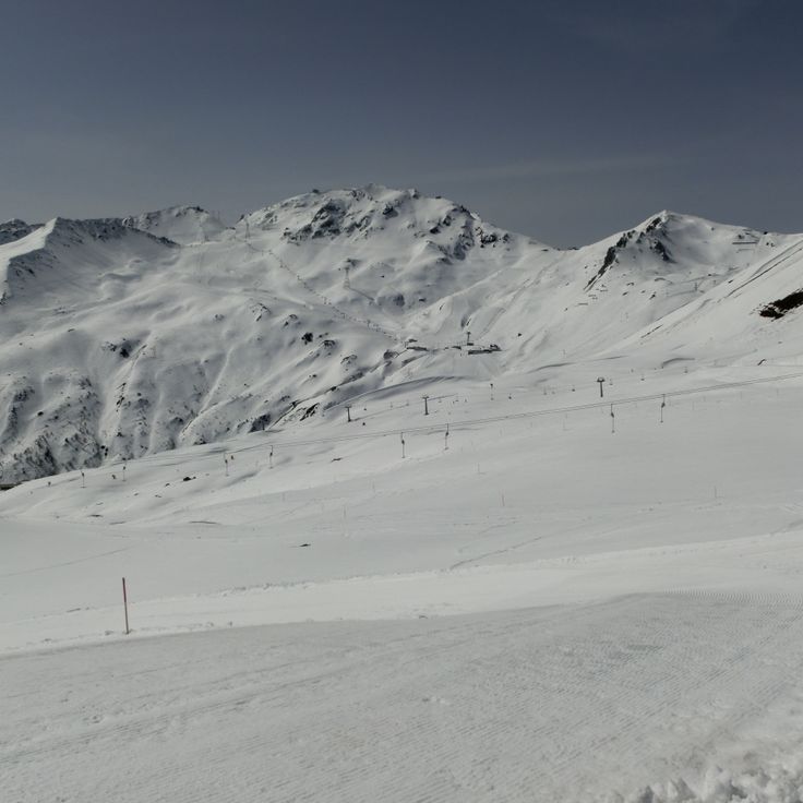
Gornergrat sits at 10,135 feet (3,089 meters) above the Zermatt valley and offers an open view of 29 peaks around it, including the Matterhorn, Monte Rosa, and Liskamm. The cogwheel train, which has been running for over a century, takes about 33 minutes to reach the top. Once there, you stand on a narrow ridge between sky and glaciers. Wind can be strong up here, the air is thin, and the silence is broken only by the calls of alpine choughs.
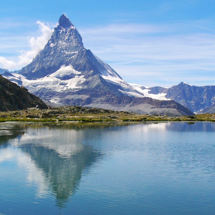
The Matterhorn rises as a solitary peak above Zermatt and the Italian border. Its pyramid shape with four ridges makes it recognizable from any angle. Climbers have attempted to scale the steep rock faces since the mid-1800s. The Hörnli Hut at 10,695 feet (3,260 meters) serves as a starting point for ascents. Cable cars run from Zermatt to the Klein Matterhorn and to Schwarzsee, where hikers and visitors can observe the mountain up close. At sunrise the north face turns pink.
This alpine lake stretches across the border between Switzerland and Italy. Wooded mountain slopes reach down to the water, and small towns sit scattered along the shores. People take small boats across the lake or walk the trails that wind through the hillsides. The water shifts color depending on the light and weather. Along the waterfront promenades, you pass gardens and old villas. In summer, locals swim at the shoreline or rest under plane trees. The mountains frame the lake and offer views into the valleys beyond.
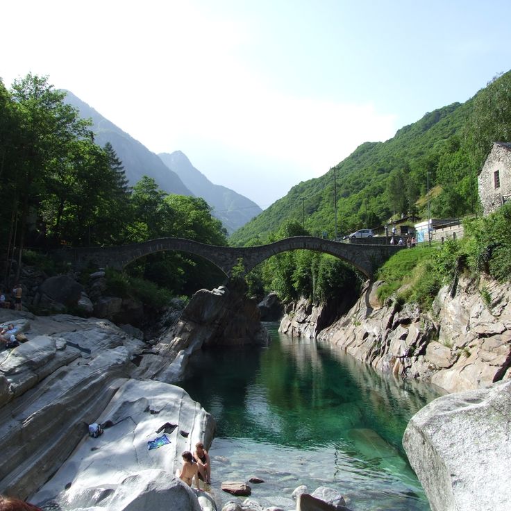
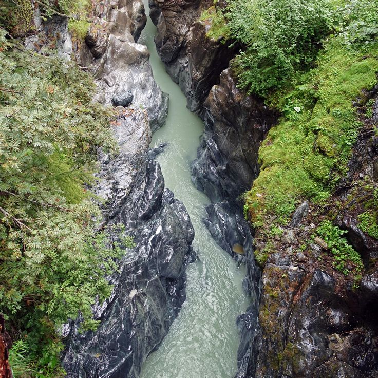
Val Verzasca runs through the Ticino Alps, following the path of the Verzasca River, a stream with green water and smooth granite rocks. The current has shaped pools and gorges over centuries, drawing swimmers and hikers today. In summer, many visitors come to bathe in the natural basins or walk along the banks. Small villages with stone houses line the road that winds through the landscape. The surroundings are quiet, and nature shows itself here in its simplest form.
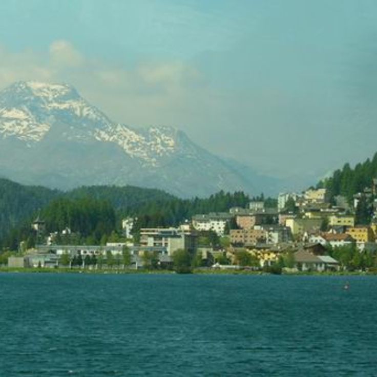
Lake St. Moritz sits at 5,800 feet (1,768 meters) above sea level, surrounded by mountains and larch forests. In winter, the frozen surface becomes a stage for horse races, polo matches, and cricket on ice. In summer, the peaks reflect in the calm water, while footpaths run along the shore. The area invites walks, and from the lakeshore, views open toward the surrounding mountains of the Upper Engadine.
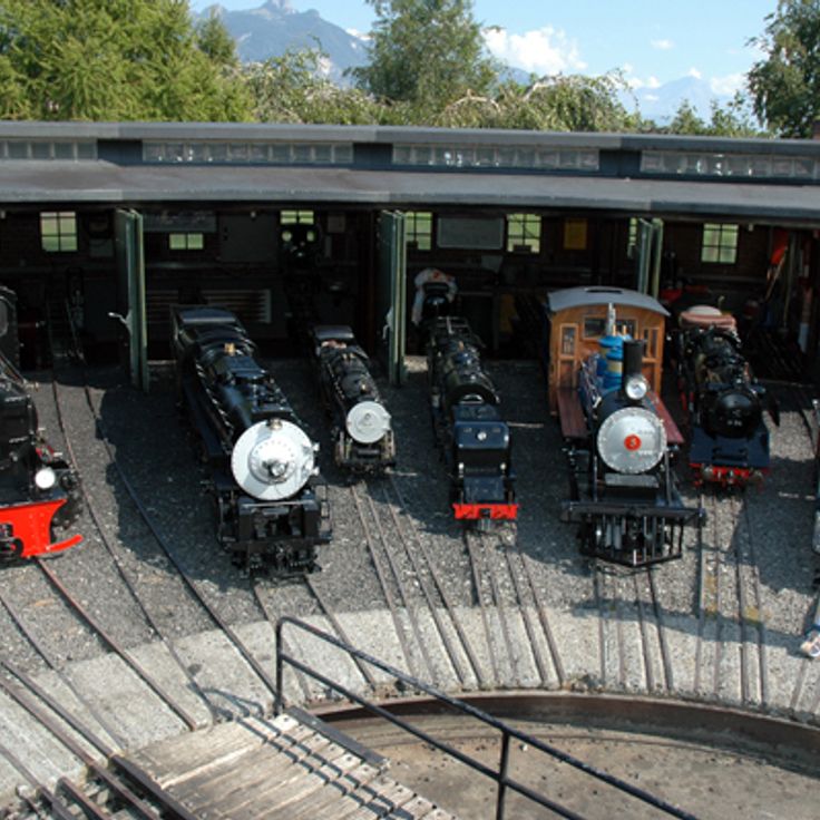
Swiss Vapeur Parc in Le Bouveret is an amusement park where steam trains run at reduced scale across a 17,000-square-meter site (roughly 183,000 square feet). The locomotives and wagons travel on narrow-gauge tracks between replicas of Swiss buildings. Visitors can ride in the trains and pass through landscapes filled with small bridges, tunnels, and miniature villages. The park combines the tradition of Swiss railroads with the pleasure of model building and engineering, all experienced outdoors.
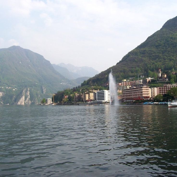
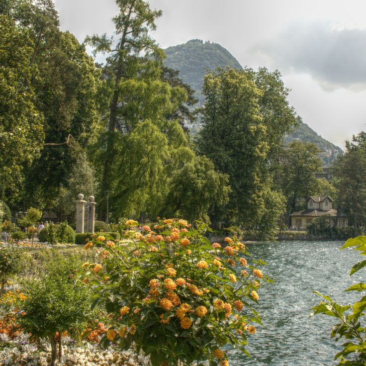
This park stretches along the shore of Lake Lugano, surrounding a nineteenth-century villa and blending lawns, mature trees and modern sculptures. The vegetation reflects the mild climate: palms, magnolias and camellias grow alongside native species. Visitors walk the lakeside paths, relax on the grass or admire the artworks scattered throughout the grounds. Ciani Park serves as a green space for the city and a venue for outdoor events.
Monte San Salvatore rises to 912 meters and offers views over Lake Lugano and the surrounding Alpine peaks. A funicular railway from 1890 connects the town to the summit, preserving the charm of Switzerland's early mountain railways. At the top, a small chapel and a few terrace steps welcome visitors. The air is often milder than farther north, and the lake spreads out below. On clear days, distant peaks appear, while the plain horizon fades into haze. This mountain belongs to the gentler face of the Swiss Alps, where vegetation and rock mingle and the light from the south already begins to show.
The Fondation Pierre Gianadda in Martigny is a cultural center that has been hosting exhibitions for decades, always with something new to discover. Beyond the rotating art shows, you will find a collection of vintage automobiles that reflects Swiss engineering tradition, and a sculpture garden with Roman artifacts unearthed in the region. The building itself connects modern architecture with traces of the past: beneath the structure lie the remains of a Gallo-Roman temple, discovered during construction. This place in the Alps shows how culture and history can grow together, without one overshadowing the other.
The Eiger rises to 3970 meters (13,025 feet) in the Bernese Alps. Its north face drops nearly vertical for 1800 meters (5905 feet) and ranks among the three great north faces of the Alps. Since the first ascent of this wall in 1938, the mountain has drawn climbers from around the world. From Grindelwald, the dark rock face stands clearly visible, and the Jungfrau Railway runs through the interior of the massif to the station at Jungfraujoch. The Eiger shapes the landscape of the Bernese Alps and remains a symbol of the challenges of mountaineering.
The Verzasca Dam stands in the Verzasca Valley and holds back the water of the river with a concrete wall. The structure generates electricity for the region and is also known as the location of a scene from a James Bond film, in which a jump from the top of the dam is shown. Today, visitors can experience this jump as a bungee activity. The dam wall rises above the forested slopes and offers a view of the turquoise water of the reservoir, which extends between the mountains.
Val Roseg stretches through the mountains above Pontresina, following the course of the Roseg River through forests of pine and larch. The hiking trails run alongside the water to the end of the valley, where glaciers appear on the slopes of the surrounding peaks. In winter, snow covers the trees and frozen ground, while summer brings green meadows and clear water flowing over the stones.
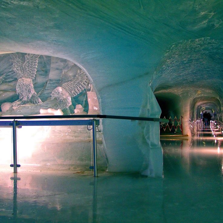
The Ice Palace at Jungfraujoch sits roughly 65 feet (20 meters) deep inside the Aletsch Glacier, at an altitude of about 11,330 feet (3454 meters). You walk through lit tunnels and rooms entirely made of glacier ice. The walls shine in shades of blue, and the temperature stays below freezing. Inside the halls, there are figures and sculptures carved directly into the ice by artists. The subjects change over time: animals, people, abstract shapes. The ice moves slowly, so the sculptures need regular renewal. Light reflects through the ice, making the corridors glow in different shades of blue.
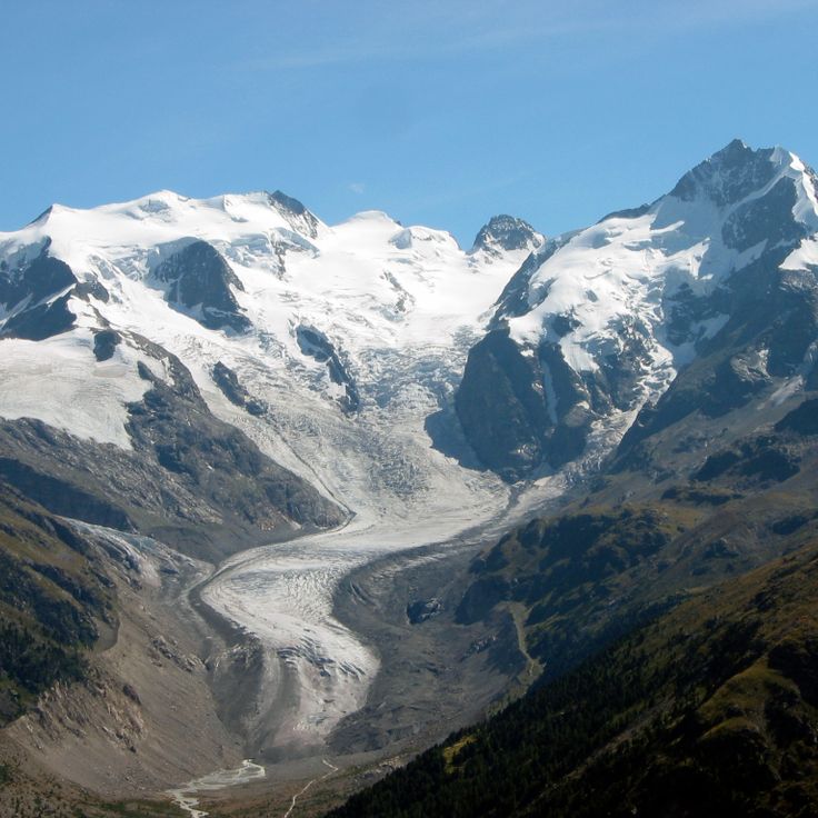
The Morteratsch Glacier was once the largest glacier in Graubünden and extended through the upper Engadine valley. A trail leads from Morteratsch to the glacier tongue and shows markers indicating where the ice stood in different years. Information panels along the path explain how the glacier has retreated since the late 19th century. The trail passes through a landscape of scree, moraines and scattered larch trees. The Piz Bernina and other peaks of the Bernina range rise in the background. The glacier itself appears gray and covered with rock dust. In summer you can hear meltwater rushing down.
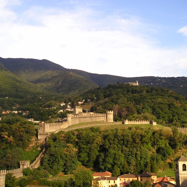
Castel Grande stands on a hill above Bellinzona and belongs to the group of three castles that have guarded the valley since the Middle Ages. Thick walls of dark stone surround the inner courtyard, where an exhibition space tells the story of the fortress. From the terrace you can see the rooftops of the town, the other two castles and the surrounding mountains. An elevator connects the town center directly to the castle.
Riffelsee sits at 9,045 feet (2,757 meters) above Zermatt and is one of the mountain lakes that draw hikers and photographers. The water reflects the Matterhorn, especially in the morning and evening when the light colors the rocks. The trail from Gornergrat leads down to the lake in about 20 minutes. In summer the water stays cold, sometimes edges freeze even in June. Families stop here for a break, some set up their tripod and wait for the right moment. The surroundings are bare, with grass and low plants between the stones. The lake lies in a hollow, sheltered from strong wind, and fills with meltwater from the nearby glaciers.
This mountain rises to 10,033 feet (3057 meters) above the Engadin valley and can be reached by cable car. From the top station, a steep slope descends where World Cup races have been held since the 1930s. The view stretches from the snowy peaks of the Bernina range to the lakes below. In winter, the mountain station is a busy place where skiers and visitors gather before heading down or simply taking in the panorama.
The Saint Gotthard Pass connects the cantons of Uri and Ticino at an altitude of 6909 feet (2106 meters). The road was paved with cobblestones in 1830 and winds through the mountains in tight hairpin turns. In summer, cars and motorcycles climb the steep switchbacks, while a few buildings stand on the pass itself. The landscape around is bare and rocky, with patches of snow that linger into summer. The pass was a major north-south route through the Alps for centuries and remains a popular stop for travelers who want to experience the old road.
Monte Tamaro is a summit at 6437 feet (1962 m), reached by cable car from Rivera. At the top you find a mountain restaurant with views over Ticino and the church of Santa Maria degli Angeli, a structure by Mario Botta from the 1990s built with stone and glass in geometric forms. In summer, hiking trails are open, including a ridge walk across to Monte Lema. If you want to spend a day in the mountains, this place offers altitude and quiet.
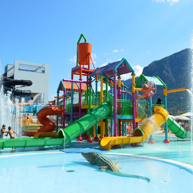
This waterpark in Le Bouveret sits by Lake Geneva and offers several pools, slides and play areas for families. The building is open year-round and combines swimming with relaxation in a region otherwise known mainly for its mountains. You will find warm water, current channels and outdoor pools that can be used even in cooler weather.
The Gorges du Gorner are a canyon carved by the Gornera river into the rock. A marked hiking trail of about 3 kilometers runs through this canyon and shows the power of water that has worked its way into the rock over thousands of years. You reach the entrance by cable car from Furri. The trail follows the river course and offers views into the geological layers and erosion patterns left by the water. The canyon is located near Zermatt and provides a quieter alternative to the higher glacial landscapes of the region.
The Jungfrau rises to 13,642 feet (4,158 meters) in the Bernese Alps. A glacier covers its slopes year-round. For over a century, a cog railway has run through the interior of the mountain to the Jungfraujoch station at 11,332 feet (3,454 meters), considered the highest railway station in Europe. From there, viewpoints open onto the surrounding sea of ice and the neighboring peaks of Eiger and Mönch. The ascent through the rock was completed in the early 20th century and brought travelers from around the world to the high Alps. The landscape around the Jungfrau has been a UNESCO World Heritage site since 2001 and shows one of the most striking glacier zones in the Alps.
Crap Sogn Gion is a summit at 7,300 feet (2,228 meters) in the Flims-Laax-Falera ski area, reached by cable car. Ski runs spread down from the top in winter. The view from up here reaches over forests and valleys to other mountains. In summer the slopes turn green and quiet, with walking trails leading from the summit.
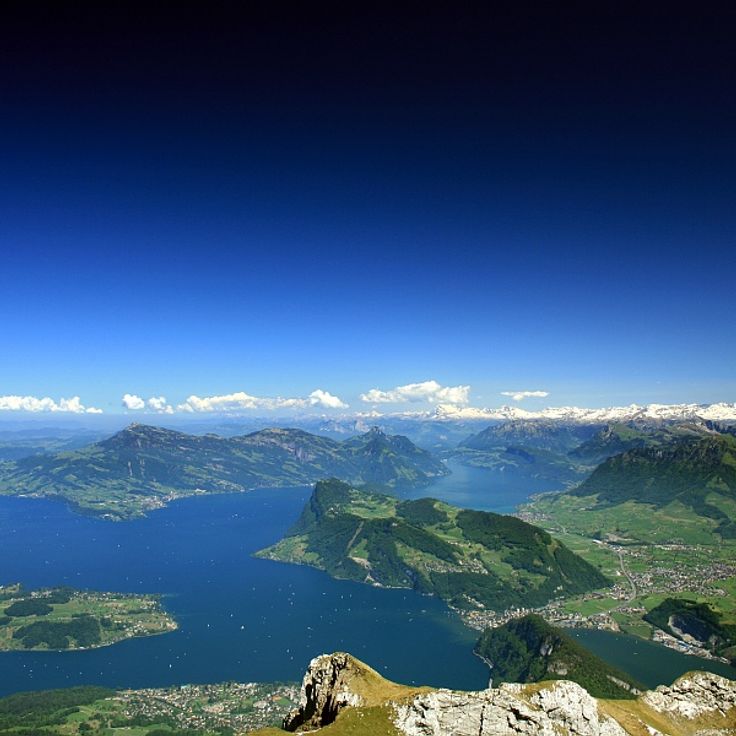
Lake Lucerne sits in the heart of central Switzerland and stretches through four cantons. The water fills a basin carved long ago by glaciers, taking a winding shape that resembles a fjord. Along the shores, steep rock faces alternate with gentle slopes where villages and small towns sit. Steamboats and modern ferries connect the settlements and offer a way to see the landscape from the water. Mountains like Rigi and Pilatus frame the lake and shape the view visitors experience. Walking paths run along the shore or climb upward, opening new views of the water below. The lake has played a role in the life of the region for centuries, serving as a route for travel, a source of fish, and a place where people come to rest.
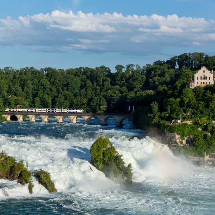
The Rhine Falls near Schaffhausen are the largest waterfalls in Europe. The water drops across a width of about 490 feet (150 meters). The drop is around 75 feet (23 meters). On some days in summer, up to 25,000 cubic feet (700 cubic meters) of water per second flow over the rocks. You can watch the falls from several viewing platforms on both banks. Small boats take visitors to the rock in the middle of the river. From there, you feel the force of the water. Spray rises and wets your face and hands. In spring and when snow melts, the river becomes even more powerful. The Rhine flows here through a layer of limestone that remained standing thousands of years ago, while the water cut deeper. The surrounding hills are forested. On the north side stands Laufen Castle, from whose terrace you have a view across the entire width of the falls.
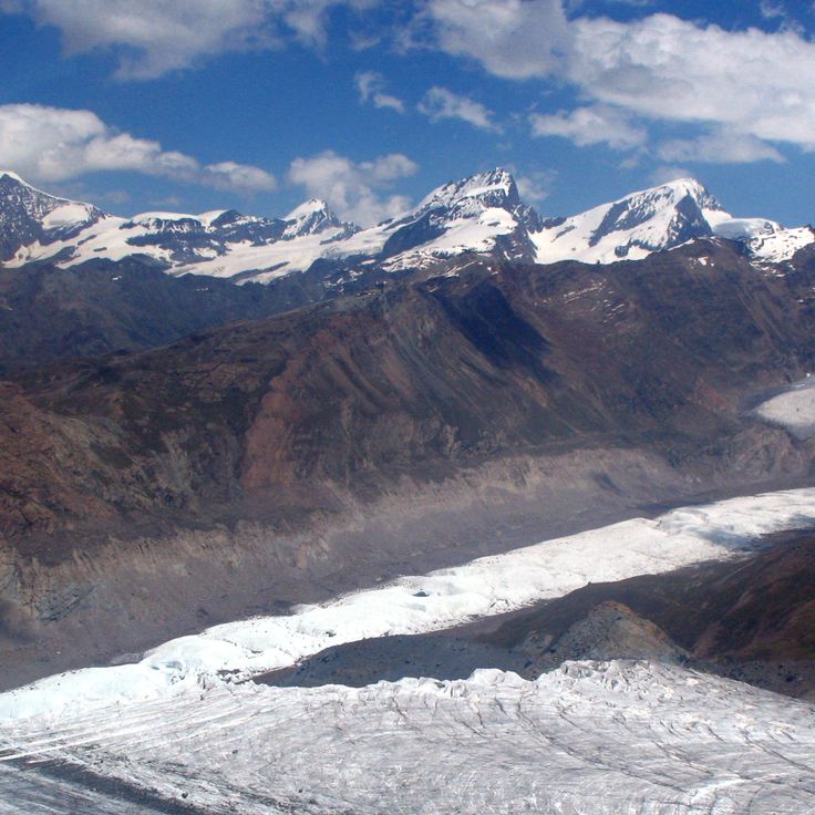
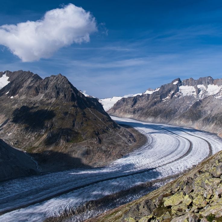
The Aletsch Glacier stretches across several valleys and flows from the high mountains down toward the forest edge. Its ice moves slowly through the landscape, carving crevasses and moraines, and shimmers in shades of blue depending on the light. Visitors who reach the viewpoints along its edges look out over a sheet of ice framed by rock walls. In summer, water rushes beneath the glacier. The surrounding area is quiet, broken only occasionally by the creaking of ice. The glacier changes from year to year, retreating and leaving new marks on the rocks.
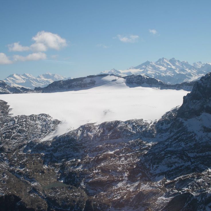
This glacier sits at 10,000 feet (3,000 meters) and ranks among the flattest in the Alps. In winter, the plateau becomes a cross-country skiing area, with tracks stretching across the white surface. In summer, hiking trails open along the glacier edges, offering views of the surrounding peaks. A cable car from Crans-Montana reaches the elevation in a few minutes. The landscape feels quiet and open, with little vegetation and much empty space. The ice is slowly retreating, and signs of this change are visible as you walk.
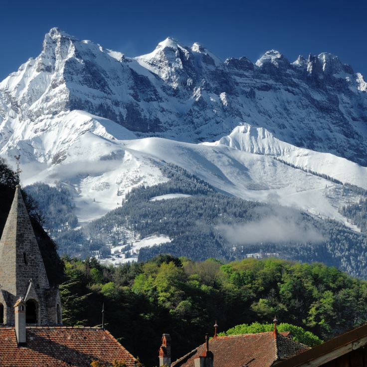
The Dents du Midi form a mountain range of seven limestone peaks rising above the Lower Valais. The highest point reaches 10,686 feet (3,257 meters). These mountains separate the Val d'Illiez from the Rhone Valley and display their jagged outlines from a distance. Hikers reach several huts from which you can observe the rock formations and the surrounding valleys. In summer, alpine meadows bloom below the rock walls, while in winter snow covers the slopes. The range is visible from many places in Valais and often serves as a landmark for travelers passing through the region.
This ski area opens between larch forests and rock faces and rises to 8562 feet (2610 meters) in elevation. The runs spread across the slopes and connect several levels through chairlifts and tow lifts. From the summit you see the Rhone Valley, the peaks across the way, and the village of Leukerbad below. In winter, skiers and snowboarders come here, in summer hikers take the same paths. The facilities are functional and have been running for several decades, with stations built of wood and metal. Snow stays here a long time, the air thins, and silence breaks only with wind and the cables of the lifts.
The Lauberhorn is a downhill course spanning more than 2.5 miles (4 kilometers), hosting a World Cup race every January since 1930. The run starts above 7500 feet (2300 meters), passes through the Hundschopf section with a jump where racers briefly take flight, and finishes in the village. The course is one of the longest in alpine racing and draws thousands of spectators along the route each winter. In summer, hiking trails cross alpine pastures and rocky slopes to the summit, where views open over the Lauterbrunnen valley and surrounding peaks.
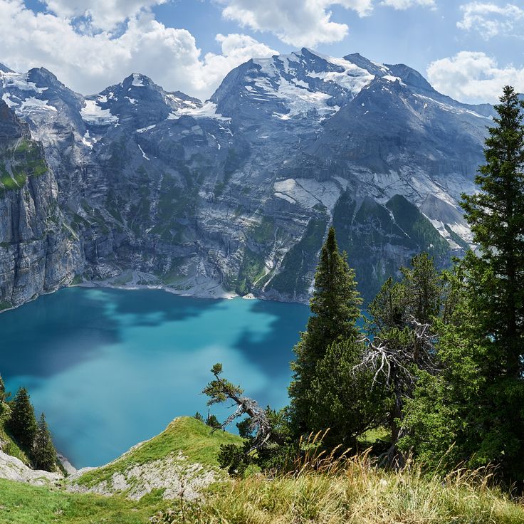
Lake Oeschinen sits at 5,177 feet (1,578 meters), surrounded by pale limestone walls and the Blüemlisalp massif. Glacier water feeds this lake where people swim and row in summer, while it freezes in winter. Trails circle the shore, suspension bridges cross certain passages, and from the cable car you can see the valley spread out below. Families come to picnic, mountaineers use the spot as a starting point for climbs into the high mountains. In autumn the meadows turn yellow and brown, while the lake reflects the rock faces that surround it.
The Parsenn connects the towns of Davos and Klosters and offers slopes for skiers and snowboarders. In winter, runs and descents open between 9,330 and 3,868 feet (2,844 and 1,179 meters) in elevation. The area works for beginners and advanced skiers. In summer, hikers walk trails that wind through alpine meadows and mountain ridges.
Gornergrat sits at 10,135 feet (3,089 meters) above the Zermatt valley and offers an open view of 29 peaks around it, including the Matterhorn, Monte Rosa, and Liskamm. The cogwheel train, which has been running for over a century, takes about 33 minutes to reach the top. Once there, you stand on a narrow ridge between sky and glaciers. Wind can be strong up here, the air is thin, and the silence is broken only by the calls of alpine choughs.
The Matterhorn rises as a solitary peak above Zermatt and the Italian border. Its pyramid shape with four ridges makes it recognizable from any angle. Climbers have attempted to scale the steep rock faces since the mid-1800s. The Hörnli Hut at 10,695 feet (3,260 meters) serves as a starting point for ascents. Cable cars run from Zermatt to the Klein Matterhorn and to Schwarzsee, where hikers and visitors can observe the mountain up close. At sunrise the north face turns pink.
This alpine lake stretches across the border between Switzerland and Italy. Wooded mountain slopes reach down to the water, and small towns sit scattered along the shores. People take small boats across the lake or walk the trails that wind through the hillsides. The water shifts color depending on the light and weather. Along the waterfront promenades, you pass gardens and old villas. In summer, locals swim at the shoreline or rest under plane trees. The mountains frame the lake and offer views into the valleys beyond.
Val Verzasca runs through the Ticino Alps, following the path of the Verzasca River, a stream with green water and smooth granite rocks. The current has shaped pools and gorges over centuries, drawing swimmers and hikers today. In summer, many visitors come to bathe in the natural basins or walk along the banks. Small villages with stone houses line the road that winds through the landscape. The surroundings are quiet, and nature shows itself here in its simplest form.
Lake St. Moritz sits at 5,800 feet (1,768 meters) above sea level, surrounded by mountains and larch forests. In winter, the frozen surface becomes a stage for horse races, polo matches, and cricket on ice. In summer, the peaks reflect in the calm water, while footpaths run along the shore. The area invites walks, and from the lakeshore, views open toward the surrounding mountains of the Upper Engadine.
Swiss Vapeur Parc in Le Bouveret is an amusement park where steam trains run at reduced scale across a 17,000-square-meter site (roughly 183,000 square feet). The locomotives and wagons travel on narrow-gauge tracks between replicas of Swiss buildings. Visitors can ride in the trains and pass through landscapes filled with small bridges, tunnels, and miniature villages. The park combines the tradition of Swiss railroads with the pleasure of model building and engineering, all experienced outdoors.
This park stretches along the shore of Lake Lugano, surrounding a nineteenth-century villa and blending lawns, mature trees and modern sculptures. The vegetation reflects the mild climate: palms, magnolias and camellias grow alongside native species. Visitors walk the lakeside paths, relax on the grass or admire the artworks scattered throughout the grounds. Ciani Park serves as a green space for the city and a venue for outdoor events.
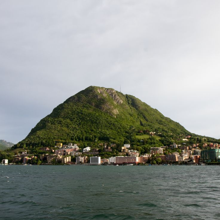
Monte San Salvatore rises to 912 meters and offers views over Lake Lugano and the surrounding Alpine peaks. A funicular railway from 1890 connects the town to the summit, preserving the charm of Switzerland's early mountain railways. At the top, a small chapel and a few terrace steps welcome visitors. The air is often milder than farther north, and the lake spreads out below. On clear days, distant peaks appear, while the plain horizon fades into haze. This mountain belongs to the gentler face of the Swiss Alps, where vegetation and rock mingle and the light from the south already begins to show.
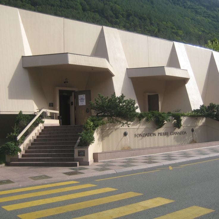
The Fondation Pierre Gianadda in Martigny is a cultural center that has been hosting exhibitions for decades, always with something new to discover. Beyond the rotating art shows, you will find a collection of vintage automobiles that reflects Swiss engineering tradition, and a sculpture garden with Roman artifacts unearthed in the region. The building itself connects modern architecture with traces of the past: beneath the structure lie the remains of a Gallo-Roman temple, discovered during construction. This place in the Alps shows how culture and history can grow together, without one overshadowing the other.
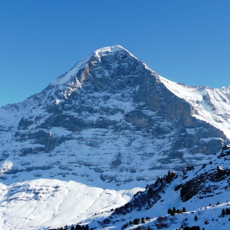
The Eiger rises to 3970 meters (13,025 feet) in the Bernese Alps. Its north face drops nearly vertical for 1800 meters (5905 feet) and ranks among the three great north faces of the Alps. Since the first ascent of this wall in 1938, the mountain has drawn climbers from around the world. From Grindelwald, the dark rock face stands clearly visible, and the Jungfrau Railway runs through the interior of the massif to the station at Jungfraujoch. The Eiger shapes the landscape of the Bernese Alps and remains a symbol of the challenges of mountaineering.
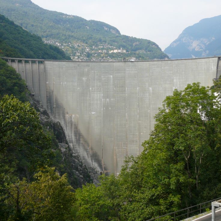
The Verzasca Dam stands in the Verzasca Valley and holds back the water of the river with a concrete wall. The structure generates electricity for the region and is also known as the location of a scene from a James Bond film, in which a jump from the top of the dam is shown. Today, visitors can experience this jump as a bungee activity. The dam wall rises above the forested slopes and offers a view of the turquoise water of the reservoir, which extends between the mountains.
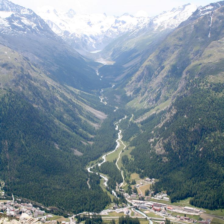
Val Roseg stretches through the mountains above Pontresina, following the course of the Roseg River through forests of pine and larch. The hiking trails run alongside the water to the end of the valley, where glaciers appear on the slopes of the surrounding peaks. In winter, snow covers the trees and frozen ground, while summer brings green meadows and clear water flowing over the stones.
The Ice Palace at Jungfraujoch sits roughly 65 feet (20 meters) deep inside the Aletsch Glacier, at an altitude of about 11,330 feet (3454 meters). You walk through lit tunnels and rooms entirely made of glacier ice. The walls shine in shades of blue, and the temperature stays below freezing. Inside the halls, there are figures and sculptures carved directly into the ice by artists. The subjects change over time: animals, people, abstract shapes. The ice moves slowly, so the sculptures need regular renewal. Light reflects through the ice, making the corridors glow in different shades of blue.
The Morteratsch Glacier was once the largest glacier in Graubünden and extended through the upper Engadine valley. A trail leads from Morteratsch to the glacier tongue and shows markers indicating where the ice stood in different years. Information panels along the path explain how the glacier has retreated since the late 19th century. The trail passes through a landscape of scree, moraines and scattered larch trees. The Piz Bernina and other peaks of the Bernina range rise in the background. The glacier itself appears gray and covered with rock dust. In summer you can hear meltwater rushing down.
Castel Grande stands on a hill above Bellinzona and belongs to the group of three castles that have guarded the valley since the Middle Ages. Thick walls of dark stone surround the inner courtyard, where an exhibition space tells the story of the fortress. From the terrace you can see the rooftops of the town, the other two castles and the surrounding mountains. An elevator connects the town center directly to the castle.
Riffelsee sits at 9,045 feet (2,757 meters) above Zermatt and is one of the mountain lakes that draw hikers and photographers. The water reflects the Matterhorn, especially in the morning and evening when the light colors the rocks. The trail from Gornergrat leads down to the lake in about 20 minutes. In summer the water stays cold, sometimes edges freeze even in June. Families stop here for a break, some set up their tripod and wait for the right moment. The surroundings are bare, with grass and low plants between the stones. The lake lies in a hollow, sheltered from strong wind, and fills with meltwater from the nearby glaciers.
This mountain rises to 10,033 feet (3057 meters) above the Engadin valley and can be reached by cable car. From the top station, a steep slope descends where World Cup races have been held since the 1930s. The view stretches from the snowy peaks of the Bernina range to the lakes below. In winter, the mountain station is a busy place where skiers and visitors gather before heading down or simply taking in the panorama.
The Saint Gotthard Pass connects the cantons of Uri and Ticino at an altitude of 6909 feet (2106 meters). The road was paved with cobblestones in 1830 and winds through the mountains in tight hairpin turns. In summer, cars and motorcycles climb the steep switchbacks, while a few buildings stand on the pass itself. The landscape around is bare and rocky, with patches of snow that linger into summer. The pass was a major north-south route through the Alps for centuries and remains a popular stop for travelers who want to experience the old road.
Monte Tamaro is a summit at 6437 feet (1962 m), reached by cable car from Rivera. At the top you find a mountain restaurant with views over Ticino and the church of Santa Maria degli Angeli, a structure by Mario Botta from the 1990s built with stone and glass in geometric forms. In summer, hiking trails are open, including a ridge walk across to Monte Lema. If you want to spend a day in the mountains, this place offers altitude and quiet.
This waterpark in Le Bouveret sits by Lake Geneva and offers several pools, slides and play areas for families. The building is open year-round and combines swimming with relaxation in a region otherwise known mainly for its mountains. You will find warm water, current channels and outdoor pools that can be used even in cooler weather.
The Gorges du Gorner are a canyon carved by the Gornera river into the rock. A marked hiking trail of about 3 kilometers runs through this canyon and shows the power of water that has worked its way into the rock over thousands of years. You reach the entrance by cable car from Furri. The trail follows the river course and offers views into the geological layers and erosion patterns left by the water. The canyon is located near Zermatt and provides a quieter alternative to the higher glacial landscapes of the region.
The Jungfrau rises to 13,642 feet (4,158 meters) in the Bernese Alps. A glacier covers its slopes year-round. For over a century, a cog railway has run through the interior of the mountain to the Jungfraujoch station at 11,332 feet (3,454 meters), considered the highest railway station in Europe. From there, viewpoints open onto the surrounding sea of ice and the neighboring peaks of Eiger and Mönch. The ascent through the rock was completed in the early 20th century and brought travelers from around the world to the high Alps. The landscape around the Jungfrau has been a UNESCO World Heritage site since 2001 and shows one of the most striking glacier zones in the Alps.
Crap Sogn Gion is a summit at 7,300 feet (2,228 meters) in the Flims-Laax-Falera ski area, reached by cable car. Ski runs spread down from the top in winter. The view from up here reaches over forests and valleys to other mountains. In summer the slopes turn green and quiet, with walking trails leading from the summit.
Lake Lucerne sits in the heart of central Switzerland and stretches through four cantons. The water fills a basin carved long ago by glaciers, taking a winding shape that resembles a fjord. Along the shores, steep rock faces alternate with gentle slopes where villages and small towns sit. Steamboats and modern ferries connect the settlements and offer a way to see the landscape from the water. Mountains like Rigi and Pilatus frame the lake and shape the view visitors experience. Walking paths run along the shore or climb upward, opening new views of the water below. The lake has played a role in the life of the region for centuries, serving as a route for travel, a source of fish, and a place where people come to rest.
The Rhine Falls near Schaffhausen are the largest waterfalls in Europe. The water drops across a width of about 490 feet (150 meters). The drop is around 75 feet (23 meters). On some days in summer, up to 25,000 cubic feet (700 cubic meters) of water per second flow over the rocks. You can watch the falls from several viewing platforms on both banks. Small boats take visitors to the rock in the middle of the river. From there, you feel the force of the water. Spray rises and wets your face and hands. In spring and when snow melts, the river becomes even more powerful. The Rhine flows here through a layer of limestone that remained standing thousands of years ago, while the water cut deeper. The surrounding hills are forested. On the north side stands Laufen Castle, from whose terrace you have a view across the entire width of the falls.
The Aletsch Glacier stretches across several valleys and flows from the high mountains down toward the forest edge. Its ice moves slowly through the landscape, carving crevasses and moraines, and shimmers in shades of blue depending on the light. Visitors who reach the viewpoints along its edges look out over a sheet of ice framed by rock walls. In summer, water rushes beneath the glacier. The surrounding area is quiet, broken only occasionally by the creaking of ice. The glacier changes from year to year, retreating and leaving new marks on the rocks.
This glacier sits at 10,000 feet (3,000 meters) and ranks among the flattest in the Alps. In winter, the plateau becomes a cross-country skiing area, with tracks stretching across the white surface. In summer, hiking trails open along the glacier edges, offering views of the surrounding peaks. A cable car from Crans-Montana reaches the elevation in a few minutes. The landscape feels quiet and open, with little vegetation and much empty space. The ice is slowly retreating, and signs of this change are visible as you walk.
The Dents du Midi form a mountain range of seven limestone peaks rising above the Lower Valais. The highest point reaches 10,686 feet (3,257 meters). These mountains separate the Val d'Illiez from the Rhone Valley and display their jagged outlines from a distance. Hikers reach several huts from which you can observe the rock formations and the surrounding valleys. In summer, alpine meadows bloom below the rock walls, while in winter snow covers the slopes. The range is visible from many places in Valais and often serves as a landmark for travelers passing through the region.
This ski area opens between larch forests and rock faces and rises to 8562 feet (2610 meters) in elevation. The runs spread across the slopes and connect several levels through chairlifts and tow lifts. From the summit you see the Rhone Valley, the peaks across the way, and the village of Leukerbad below. In winter, skiers and snowboarders come here, in summer hikers take the same paths. The facilities are functional and have been running for several decades, with stations built of wood and metal. Snow stays here a long time, the air thins, and silence breaks only with wind and the cables of the lifts.
The Lauberhorn is a downhill course spanning more than 2.5 miles (4 kilometers), hosting a World Cup race every January since 1930. The run starts above 7500 feet (2300 meters), passes through the Hundschopf section with a jump where racers briefly take flight, and finishes in the village. The course is one of the longest in alpine racing and draws thousands of spectators along the route each winter. In summer, hiking trails cross alpine pastures and rocky slopes to the summit, where views open over the Lauterbrunnen valley and surrounding peaks.
Lake Oeschinen sits at 5,177 feet (1,578 meters), surrounded by pale limestone walls and the Blüemlisalp massif. Glacier water feeds this lake where people swim and row in summer, while it freezes in winter. Trails circle the shore, suspension bridges cross certain passages, and from the cable car you can see the valley spread out below. Families come to picnic, mountaineers use the spot as a starting point for climbs into the high mountains. In autumn the meadows turn yellow and brown, while the lake reflects the rock faces that surround it.
The Parsenn connects the towns of Davos and Klosters and offers slopes for skiers and snowboarders. In winter, runs and descents open between 9,330 and 3,868 feet (2,844 and 1,179 meters) in elevation. The area works for beginners and advanced skiers. In summer, hikers walk trails that wind through alpine meadows and mountain ridges.
Gornergrat sits at 10,135 feet (3,089 meters) above the Zermatt valley and offers an open view of 29 peaks around it, including the Matterhorn, Monte Rosa, and Liskamm. The cogwheel train, which has been running for over a century, takes about 33 minutes to reach the top. Once there, you stand on a narrow ridge between sky and glaciers. Wind can be strong up here, the air is thin, and the silence is broken only by the calls of alpine choughs.
The Matterhorn rises as a solitary peak above Zermatt and the Italian border. Its pyramid shape with four ridges makes it recognizable from any angle. Climbers have attempted to scale the steep rock faces since the mid-1800s. The Hörnli Hut at 10,695 feet (3,260 meters) serves as a starting point for ascents. Cable cars run from Zermatt to the Klein Matterhorn and to Schwarzsee, where hikers and visitors can observe the mountain up close. At sunrise the north face turns pink.
This alpine lake stretches across the border between Switzerland and Italy. Wooded mountain slopes reach down to the water, and small towns sit scattered along the shores. People take small boats across the lake or walk the trails that wind through the hillsides. The water shifts color depending on the light and weather. Along the waterfront promenades, you pass gardens and old villas. In summer, locals swim at the shoreline or rest under plane trees. The mountains frame the lake and offer views into the valleys beyond.
Val Verzasca runs through the Ticino Alps, following the path of the Verzasca River, a stream with green water and smooth granite rocks. The current has shaped pools and gorges over centuries, drawing swimmers and hikers today. In summer, many visitors come to bathe in the natural basins or walk along the banks. Small villages with stone houses line the road that winds through the landscape. The surroundings are quiet, and nature shows itself here in its simplest form.
Lake St. Moritz sits at 5,800 feet (1,768 meters) above sea level, surrounded by mountains and larch forests. In winter, the frozen surface becomes a stage for horse races, polo matches, and cricket on ice. In summer, the peaks reflect in the calm water, while footpaths run along the shore. The area invites walks, and from the lakeshore, views open toward the surrounding mountains of the Upper Engadine.
Swiss Vapeur Parc in Le Bouveret is an amusement park where steam trains run at reduced scale across a 17,000-square-meter site (roughly 183,000 square feet). The locomotives and wagons travel on narrow-gauge tracks between replicas of Swiss buildings. Visitors can ride in the trains and pass through landscapes filled with small bridges, tunnels, and miniature villages. The park combines the tradition of Swiss railroads with the pleasure of model building and engineering, all experienced outdoors.
This park stretches along the shore of Lake Lugano, surrounding a nineteenth-century villa and blending lawns, mature trees and modern sculptures. The vegetation reflects the mild climate: palms, magnolias and camellias grow alongside native species. Visitors walk the lakeside paths, relax on the grass or admire the artworks scattered throughout the grounds. Ciani Park serves as a green space for the city and a venue for outdoor events.
Monte San Salvatore rises to 912 meters and offers views over Lake Lugano and the surrounding Alpine peaks. A funicular railway from 1890 connects the town to the summit, preserving the charm of Switzerland's early mountain railways. At the top, a small chapel and a few terrace steps welcome visitors. The air is often milder than farther north, and the lake spreads out below. On clear days, distant peaks appear, while the plain horizon fades into haze. This mountain belongs to the gentler face of the Swiss Alps, where vegetation and rock mingle and the light from the south already begins to show.
The Fondation Pierre Gianadda in Martigny is a cultural center that has been hosting exhibitions for decades, always with something new to discover. Beyond the rotating art shows, you will find a collection of vintage automobiles that reflects Swiss engineering tradition, and a sculpture garden with Roman artifacts unearthed in the region. The building itself connects modern architecture with traces of the past: beneath the structure lie the remains of a Gallo-Roman temple, discovered during construction. This place in the Alps shows how culture and history can grow together, without one overshadowing the other.
The Eiger rises to 3970 meters (13,025 feet) in the Bernese Alps. Its north face drops nearly vertical for 1800 meters (5905 feet) and ranks among the three great north faces of the Alps. Since the first ascent of this wall in 1938, the mountain has drawn climbers from around the world. From Grindelwald, the dark rock face stands clearly visible, and the Jungfrau Railway runs through the interior of the massif to the station at Jungfraujoch. The Eiger shapes the landscape of the Bernese Alps and remains a symbol of the challenges of mountaineering.
The Verzasca Dam stands in the Verzasca Valley and holds back the water of the river with a concrete wall. The structure generates electricity for the region and is also known as the location of a scene from a James Bond film, in which a jump from the top of the dam is shown. Today, visitors can experience this jump as a bungee activity. The dam wall rises above the forested slopes and offers a view of the turquoise water of the reservoir, which extends between the mountains.
Val Roseg stretches through the mountains above Pontresina, following the course of the Roseg River through forests of pine and larch. The hiking trails run alongside the water to the end of the valley, where glaciers appear on the slopes of the surrounding peaks. In winter, snow covers the trees and frozen ground, while summer brings green meadows and clear water flowing over the stones.
The Ice Palace at Jungfraujoch sits roughly 65 feet (20 meters) deep inside the Aletsch Glacier, at an altitude of about 11,330 feet (3454 meters). You walk through lit tunnels and rooms entirely made of glacier ice. The walls shine in shades of blue, and the temperature stays below freezing. Inside the halls, there are figures and sculptures carved directly into the ice by artists. The subjects change over time: animals, people, abstract shapes. The ice moves slowly, so the sculptures need regular renewal. Light reflects through the ice, making the corridors glow in different shades of blue.
The Morteratsch Glacier was once the largest glacier in Graubünden and extended through the upper Engadine valley. A trail leads from Morteratsch to the glacier tongue and shows markers indicating where the ice stood in different years. Information panels along the path explain how the glacier has retreated since the late 19th century. The trail passes through a landscape of scree, moraines and scattered larch trees. The Piz Bernina and other peaks of the Bernina range rise in the background. The glacier itself appears gray and covered with rock dust. In summer you can hear meltwater rushing down.
Castel Grande stands on a hill above Bellinzona and belongs to the group of three castles that have guarded the valley since the Middle Ages. Thick walls of dark stone surround the inner courtyard, where an exhibition space tells the story of the fortress. From the terrace you can see the rooftops of the town, the other two castles and the surrounding mountains. An elevator connects the town center directly to the castle.
Riffelsee sits at 9,045 feet (2,757 meters) above Zermatt and is one of the mountain lakes that draw hikers and photographers. The water reflects the Matterhorn, especially in the morning and evening when the light colors the rocks. The trail from Gornergrat leads down to the lake in about 20 minutes. In summer the water stays cold, sometimes edges freeze even in June. Families stop here for a break, some set up their tripod and wait for the right moment. The surroundings are bare, with grass and low plants between the stones. The lake lies in a hollow, sheltered from strong wind, and fills with meltwater from the nearby glaciers.
This mountain rises to 10,033 feet (3057 meters) above the Engadin valley and can be reached by cable car. From the top station, a steep slope descends where World Cup races have been held since the 1930s. The view stretches from the snowy peaks of the Bernina range to the lakes below. In winter, the mountain station is a busy place where skiers and visitors gather before heading down or simply taking in the panorama.
The Saint Gotthard Pass connects the cantons of Uri and Ticino at an altitude of 6909 feet (2106 meters). The road was paved with cobblestones in 1830 and winds through the mountains in tight hairpin turns. In summer, cars and motorcycles climb the steep switchbacks, while a few buildings stand on the pass itself. The landscape around is bare and rocky, with patches of snow that linger into summer. The pass was a major north-south route through the Alps for centuries and remains a popular stop for travelers who want to experience the old road.
Monte Tamaro is a summit at 6437 feet (1962 m), reached by cable car from Rivera. At the top you find a mountain restaurant with views over Ticino and the church of Santa Maria degli Angeli, a structure by Mario Botta from the 1990s built with stone and glass in geometric forms. In summer, hiking trails are open, including a ridge walk across to Monte Lema. If you want to spend a day in the mountains, this place offers altitude and quiet.
This waterpark in Le Bouveret sits by Lake Geneva and offers several pools, slides and play areas for families. The building is open year-round and combines swimming with relaxation in a region otherwise known mainly for its mountains. You will find warm water, current channels and outdoor pools that can be used even in cooler weather.
The Gorges du Gorner are a canyon carved by the Gornera river into the rock. A marked hiking trail of about 3 kilometers runs through this canyon and shows the power of water that has worked its way into the rock over thousands of years. You reach the entrance by cable car from Furri. The trail follows the river course and offers views into the geological layers and erosion patterns left by the water. The canyon is located near Zermatt and provides a quieter alternative to the higher glacial landscapes of the region.
The Jungfrau rises to 13,642 feet (4,158 meters) in the Bernese Alps. A glacier covers its slopes year-round. For over a century, a cog railway has run through the interior of the mountain to the Jungfraujoch station at 11,332 feet (3,454 meters), considered the highest railway station in Europe. From there, viewpoints open onto the surrounding sea of ice and the neighboring peaks of Eiger and Mönch. The ascent through the rock was completed in the early 20th century and brought travelers from around the world to the high Alps. The landscape around the Jungfrau has been a UNESCO World Heritage site since 2001 and shows one of the most striking glacier zones in the Alps.
Crap Sogn Gion is a summit at 7,300 feet (2,228 meters) in the Flims-Laax-Falera ski area, reached by cable car. Ski runs spread down from the top in winter. The view from up here reaches over forests and valleys to other mountains. In summer the slopes turn green and quiet, with walking trails leading from the summit.
Lake Lucerne sits in the heart of central Switzerland and stretches through four cantons. The water fills a basin carved long ago by glaciers, taking a winding shape that resembles a fjord. Along the shores, steep rock faces alternate with gentle slopes where villages and small towns sit. Steamboats and modern ferries connect the settlements and offer a way to see the landscape from the water. Mountains like Rigi and Pilatus frame the lake and shape the view visitors experience. Walking paths run along the shore or climb upward, opening new views of the water below. The lake has played a role in the life of the region for centuries, serving as a route for travel, a source of fish, and a place where people come to rest.
The Rhine Falls near Schaffhausen are the largest waterfalls in Europe. The water drops across a width of about 490 feet (150 meters). The drop is around 75 feet (23 meters). On some days in summer, up to 25,000 cubic feet (700 cubic meters) of water per second flow over the rocks. You can watch the falls from several viewing platforms on both banks. Small boats take visitors to the rock in the middle of the river. From there, you feel the force of the water. Spray rises and wets your face and hands. In spring and when snow melts, the river becomes even more powerful. The Rhine flows here through a layer of limestone that remained standing thousands of years ago, while the water cut deeper. The surrounding hills are forested. On the north side stands Laufen Castle, from whose terrace you have a view across the entire width of the falls.
The Aletsch Glacier stretches across several valleys and flows from the high mountains down toward the forest edge. Its ice moves slowly through the landscape, carving crevasses and moraines, and shimmers in shades of blue depending on the light. Visitors who reach the viewpoints along its edges look out over a sheet of ice framed by rock walls. In summer, water rushes beneath the glacier. The surrounding area is quiet, broken only occasionally by the creaking of ice. The glacier changes from year to year, retreating and leaving new marks on the rocks.
This glacier sits at 10,000 feet (3,000 meters) and ranks among the flattest in the Alps. In winter, the plateau becomes a cross-country skiing area, with tracks stretching across the white surface. In summer, hiking trails open along the glacier edges, offering views of the surrounding peaks. A cable car from Crans-Montana reaches the elevation in a few minutes. The landscape feels quiet and open, with little vegetation and much empty space. The ice is slowly retreating, and signs of this change are visible as you walk.
The Dents du Midi form a mountain range of seven limestone peaks rising above the Lower Valais. The highest point reaches 10,686 feet (3,257 meters). These mountains separate the Val d'Illiez from the Rhone Valley and display their jagged outlines from a distance. Hikers reach several huts from which you can observe the rock formations and the surrounding valleys. In summer, alpine meadows bloom below the rock walls, while in winter snow covers the slopes. The range is visible from many places in Valais and often serves as a landmark for travelers passing through the region.
This ski area opens between larch forests and rock faces and rises to 8562 feet (2610 meters) in elevation. The runs spread across the slopes and connect several levels through chairlifts and tow lifts. From the summit you see the Rhone Valley, the peaks across the way, and the village of Leukerbad below. In winter, skiers and snowboarders come here, in summer hikers take the same paths. The facilities are functional and have been running for several decades, with stations built of wood and metal. Snow stays here a long time, the air thins, and silence breaks only with wind and the cables of the lifts.
The Lauberhorn is a downhill course spanning more than 2.5 miles (4 kilometers), hosting a World Cup race every January since 1930. The run starts above 7500 feet (2300 meters), passes through the Hundschopf section with a jump where racers briefly take flight, and finishes in the village. The course is one of the longest in alpine racing and draws thousands of spectators along the route each winter. In summer, hiking trails cross alpine pastures and rocky slopes to the summit, where views open over the Lauterbrunnen valley and surrounding peaks.
Lake Oeschinen sits at 5,177 feet (1,578 meters), surrounded by pale limestone walls and the Blüemlisalp massif. Glacier water feeds this lake where people swim and row in summer, while it freezes in winter. Trails circle the shore, suspension bridges cross certain passages, and from the cable car you can see the valley spread out below. Families come to picnic, mountaineers use the spot as a starting point for climbs into the high mountains. In autumn the meadows turn yellow and brown, while the lake reflects the rock faces that surround it.
The Parsenn connects the towns of Davos and Klosters and offers slopes for skiers and snowboarders. In winter, runs and descents open between 9,330 and 3,868 feet (2,844 and 1,179 meters) in elevation. The area works for beginners and advanced skiers. In summer, hikers walk trails that wind through alpine meadows and mountain ridges.