Glaciers shape the land from the highest mountains in the Andes to cold regions, holding most of the planet's fresh water.
Glaciers represent some of the most remarkable natural formations on Earth. These ice masses form over centuries through the compression of snow and move slowly through valleys and across mountain slopes. They shape landscapes from the Patagonian Andes to Arctic regions and store approximately 70 percent of the world's freshwater.
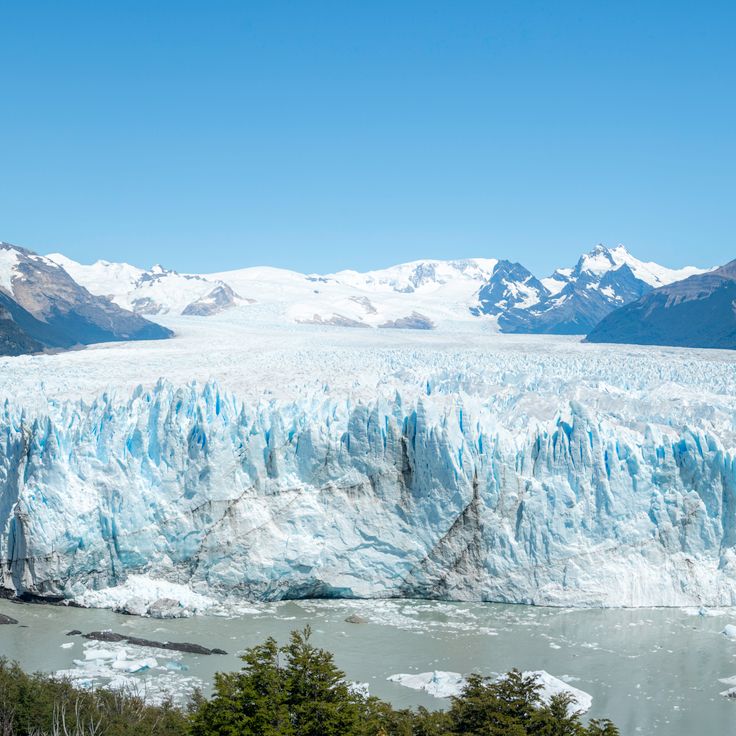
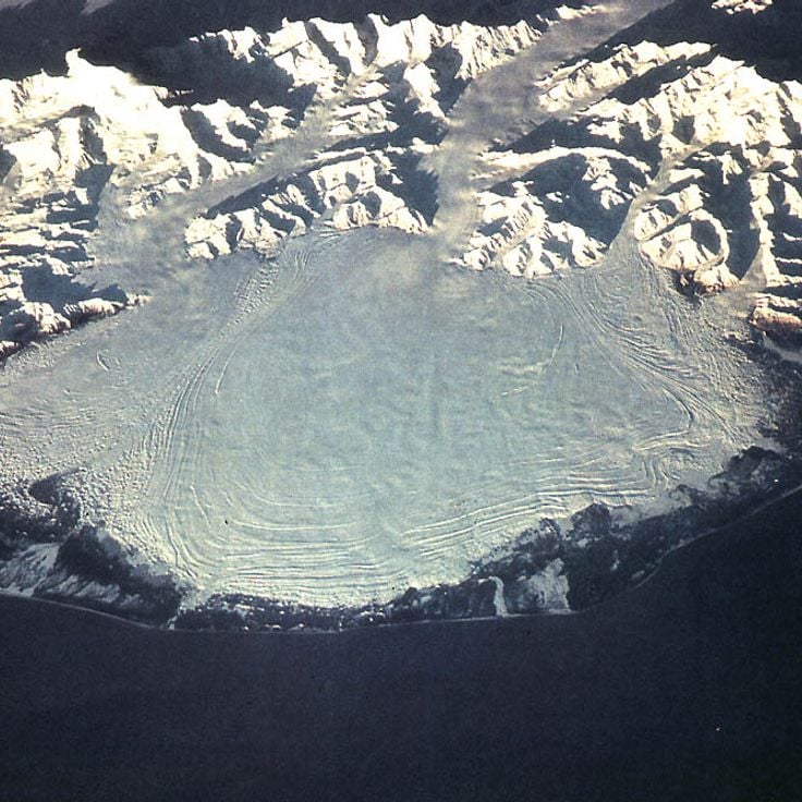
The Perito Moreno Glacier in Argentina covers 250 square kilometers and ranks among the few glaciers currently not retreating. The Jostedalsbreen in Norway forms the largest ice mass on mainland Europe at 487 square kilometers. The Vatnajökull in Iceland covers eight percent of the country's land area and conceals several active volcanoes beneath its ice cap.
These glaciers serve science as climate archives and demonstrate through their changes the effects of rising temperatures. Many glaciers worldwide continuously lose mass, which has consequences for water supply and sea levels.
Glaciers shape the land from the highest mountains in the Andes to cold regions, holding most of the planet's fresh water.
Glaciers represent some of the most remarkable natural formations on Earth. These ice masses form over centuries through the compression of snow and move slowly through valleys and across mountain slopes. They shape landscapes from the Patagonian Andes to Arctic regions and store approximately 70 percent of the world's freshwater.
The Perito Moreno Glacier in Argentina covers 250 square kilometers and ranks among the few glaciers currently not retreating. The Jostedalsbreen in Norway forms the largest ice mass on mainland Europe at 487 square kilometers. The Vatnajökull in Iceland covers eight percent of the country's land area and conceals several active volcanoes beneath its ice cap.
These glaciers serve science as climate archives and demonstrate through their changes the effects of rising temperatures. Many glaciers worldwide continuously lose mass, which has consequences for water supply and sea levels.
The Perito Moreno Glacier covers an area of 250 square kilometers and rises 74 meters above the water level of Lago Argentino. This glacier moves forward continuously at a rate of approximately two meters per day. This movement causes large masses of ice to regularly break off from the glacier wall and fall into the lake. The phenomenon occurs when the glacier forms a natural ice bridge that blocks the southern arm of the lake and eventually collapses under water pressure.
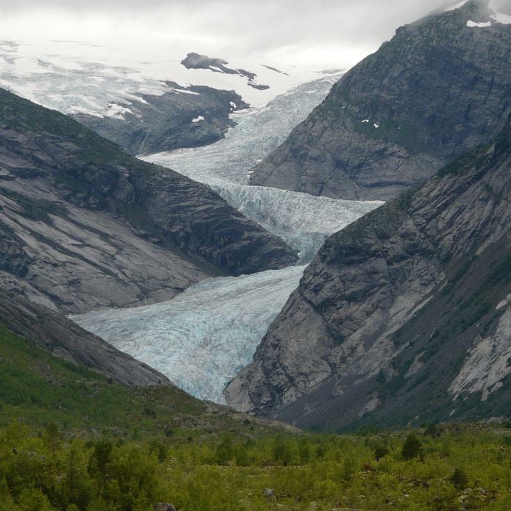
Jostedalsbreen covers 487 square kilometers and forms the largest ice cap on mainland Europe. This glacier sits between the mountains of Jostedalsbreen National Park and feeds 24 glacier tongues that descend into different valleys. The ice reaches depths of over 600 meters in places. Notable outlets include Briksdalsbreen and Nigardsbreen, both accessible for glacier hiking. The glacier forms through heavy snowfall at elevations between 1,200 and 2,000 meters.
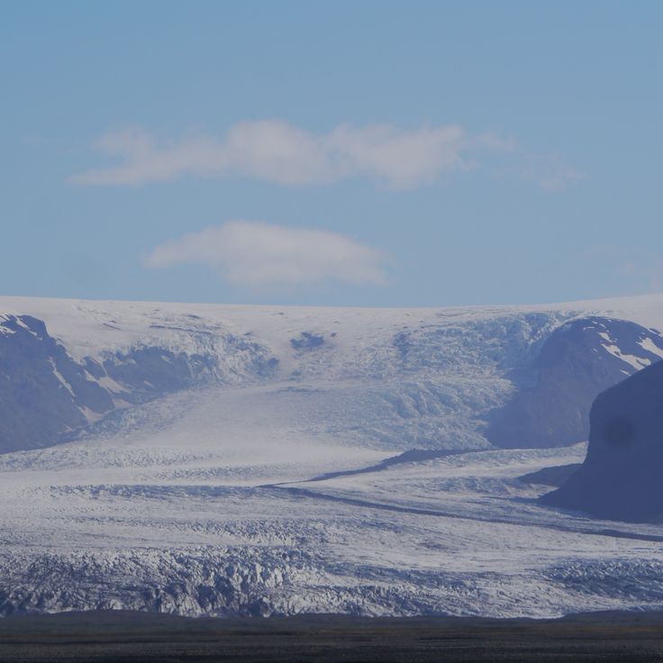
Vatnajökull is the largest ice cap in Europe, covering 8100 square kilometers in eastern Iceland. Several active volcanoes lie beneath the ice sheet, including Grímsvötn and Bárðarbunga, which erupt regularly. The ice cap reaches thicknesses of up to 1000 meters in some areas. The glacier feeds numerous glacial rivers and forms ice caves that constantly change due to geothermal activity. The surrounding Vatnajökull National Park protects diverse landscapes, from glacier tongues to volcanic deserts.
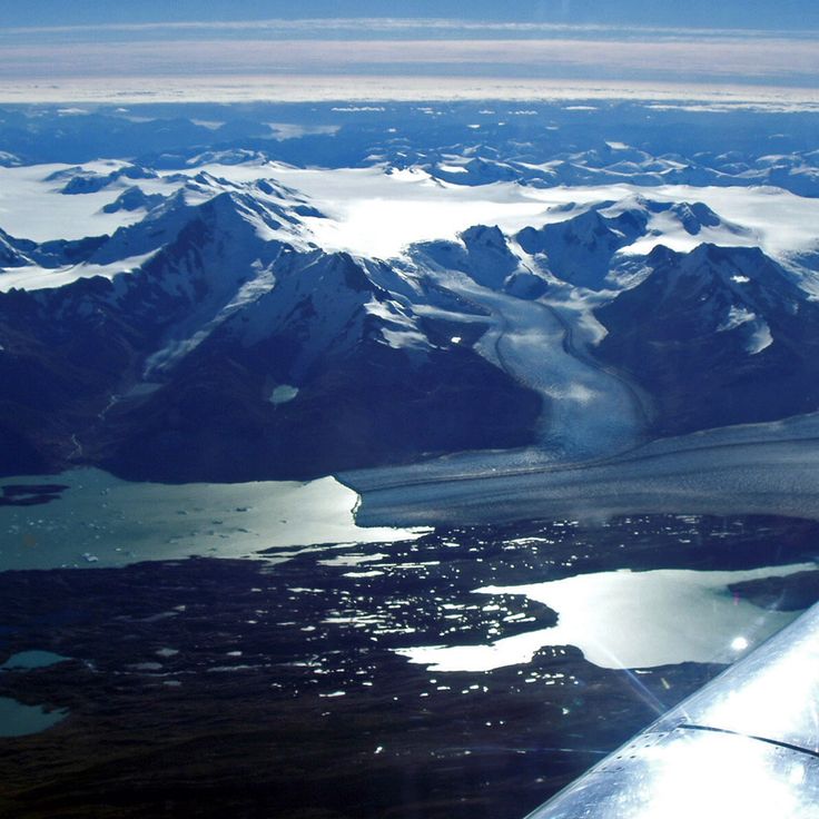
The Glacier Bay is located in the southeast of Alaska and is home to seven active tidewater glaciers that flow directly into the sea. These glaciers calve regularly, producing icebergs of different sizes that drift in the bay's waters. The area covers about 13,000 square miles and has recorded glacier retreat since the late 1700s. The bay is a natural site for studying glacier activity and how plants and animals return after the ice moves back.
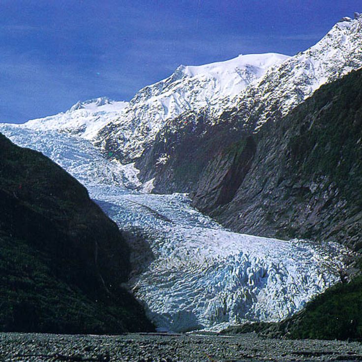
Fox Glacier extends 13 kilometers through a valley in the Southern Alps of New Zealand. The ice flows down from mountain slopes to an elevation of approximately 300 meters above sea level, where it terminates in temperate rainforest. The glacier moves at an average rate of one meter per day and forms ice caves and crevasses. Several walking tracks lead to viewing points where visitors can observe the ice formations and the glacial valley.
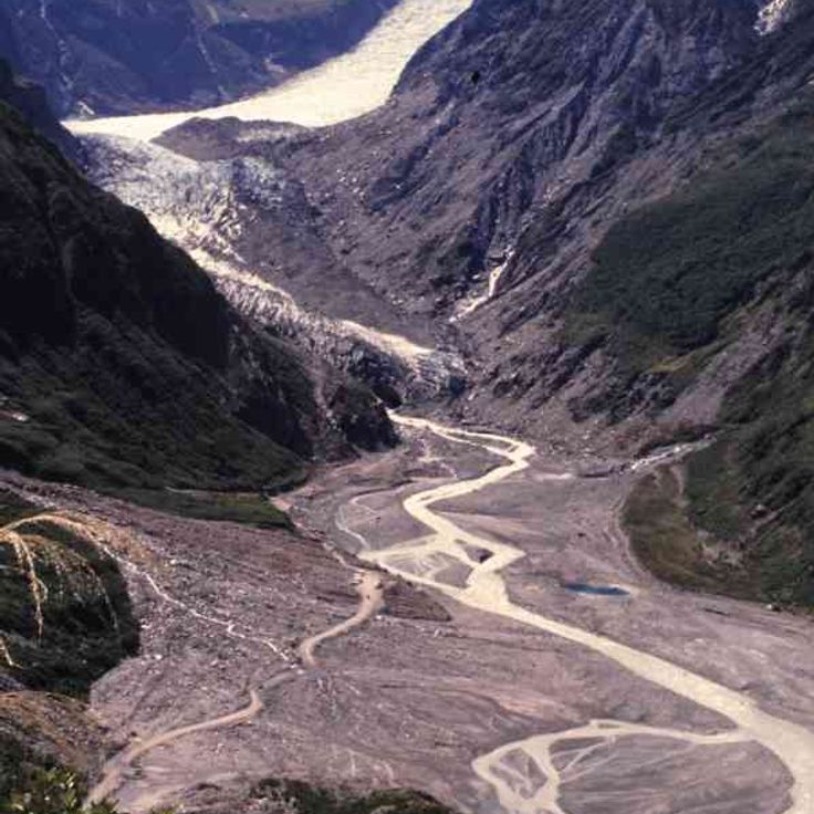
The Franz Josef Glacier extends 12 kilometers along the West Coast of New Zealand's South Island. This glacier moves at speeds of up to 4 meters per day, making it one of the fastest flowing glaciers in temperate regions. The Franz Josef Glacier originates in the Southern Alps at approximately 2700 meters elevation and descends to 240 meters above sea level. The glacier valley offers various walking tracks and guided tours that allow visitors to observe the ice formations up close.
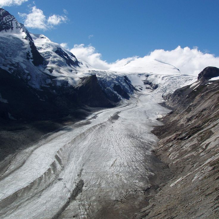
The Pasterze Glacier extends over a length of 8.4 kilometers and covers an area of 19.5 square kilometers in the Hohe Tauern range. This glacier sits at the base of Grossglockner, Austria's highest mountain, and forms the largest ice field in the country. The glacier shows clear evidence of climate change with continuous reduction in its mass and extent since the 19th century. From the Franz-Josefs-Höhe viewpoint, visitors can observe the entire glacier basin and examine the ice formations and crevasses that characterize its surface.
The Jakobshavn Glacier is one of the most active glaciers in the world, advancing between 30 and 50 meters per day. It flows into the Ilulissat Icefjord on the western coast of Greenland and is responsible for producing approximately 10 percent of all icebergs that calve in Greenlandic waters. The glacier drains about 6.5 percent of the Greenland Ice Sheet and has experienced substantial mass loss in recent decades.
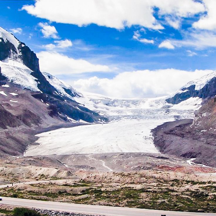
The Athabasca Glacier extends six kilometers from the Columbia Icefield into the valleys of the Canadian Rockies. This glacier tongue sits on the border between Alberta and British Columbia at elevations ranging from 2100 to 3500 meters. The glacier is accessible from the Icefields Parkway and loses approximately five meters in thickness each year due to rising temperatures. Scientific measurements have documented its continuous retreat since the 1840s.
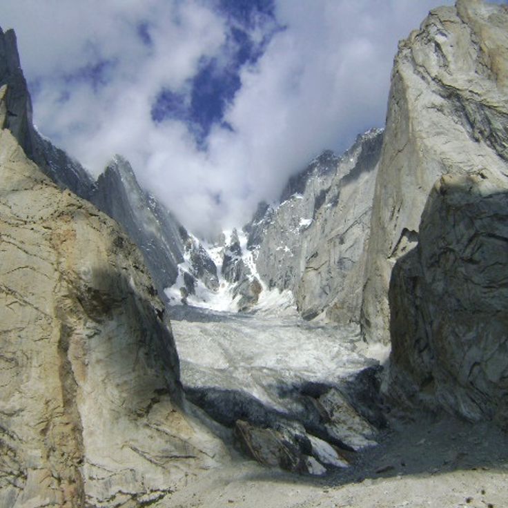
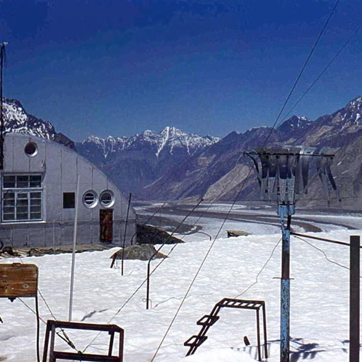
The Siachen Glacier extends over 76 kilometers in length and sits at an elevation of 5,753 meters in the eastern Karakoram range. This glacier has formed the line of control between Indian and Pakistani administered territories for decades. The extreme weather conditions with temperatures dropping to minus 50 degrees Celsius make this location one of the most challenging military deployment sites in the world.
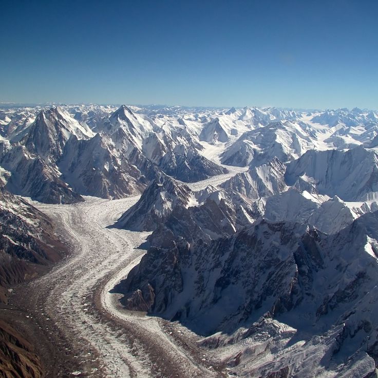
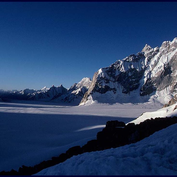
The Baltoro Glacier extends 63 kilometers through the Karakoram range and ranks among the longest glaciers outside polar regions. This glacier serves as the primary access route to four eight-thousanders, including K2 at 8,611 meters, the second highest mountain on Earth. The ice streams of the Baltoro are fed by numerous tributary glaciers and form the source of the Shigar River. Mountaineers and expeditions use the route along the glacier as a base for ascents to the surrounding peaks.
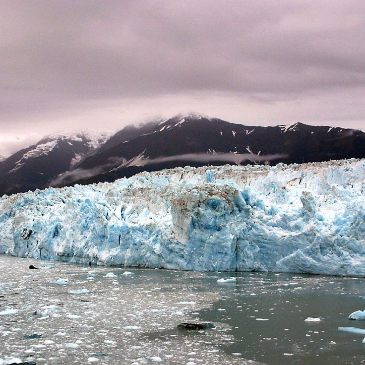
Hubbard Glacier extends 122 kilometers through the Saint Elias Mountains and demonstrates a phenomenon that has become rare worldwide: it advances approximately 24 meters each year. This mass gain contrasts with the global trend of glacier retreat. The glacier terminates at Disenchantment Bay and Yakutat Bay in Alaska. Its width reaches approximately 10 kilometers at the calving face, where large blocks of ice regularly break off into the ocean.
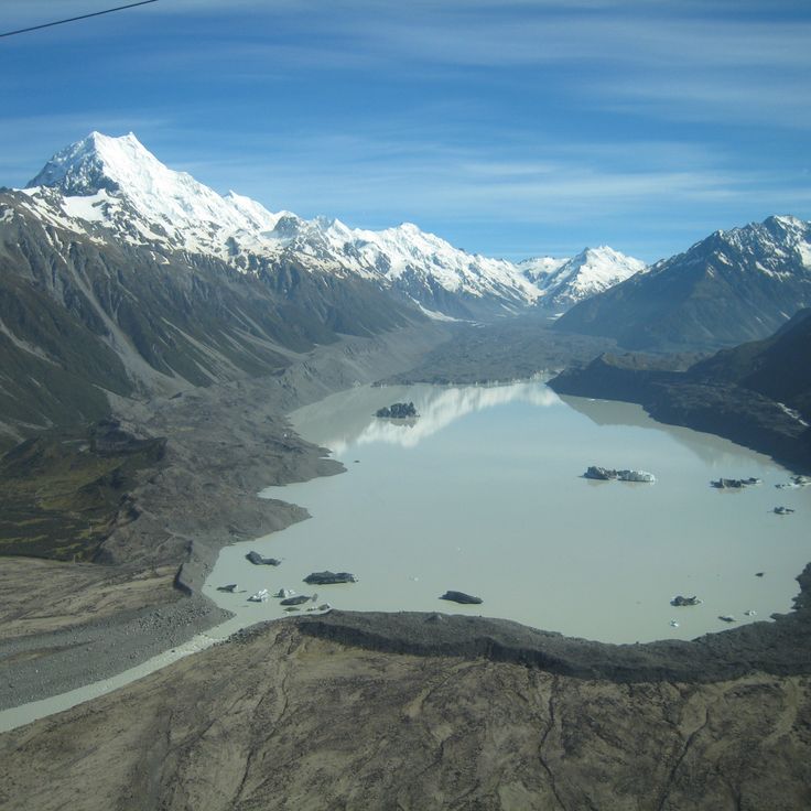
The Tasman Glacier extends for 23 kilometres through Aoraki Mount Cook National Park on New Zealand's South Island. This glacier sits at the base of Mount Cook, the country's highest peak, and flows down a valley between the mountain ranges of the Southern Alps. Since 1990, the Tasman Glacier has been retreating at a rate of approximately 180 metres per year due to glacial melting. At its widest point, the glacier measures about four kilometres across. The lower section of the glacier terminates in a glacial lake that has formed over recent decades as the ice melts. This lake continues to expand as the glacier retreats. Visitors can access the glacier area via walking tracks or take boat tours on the glacial lake to observe the floating icebergs that calve from the glacier face.
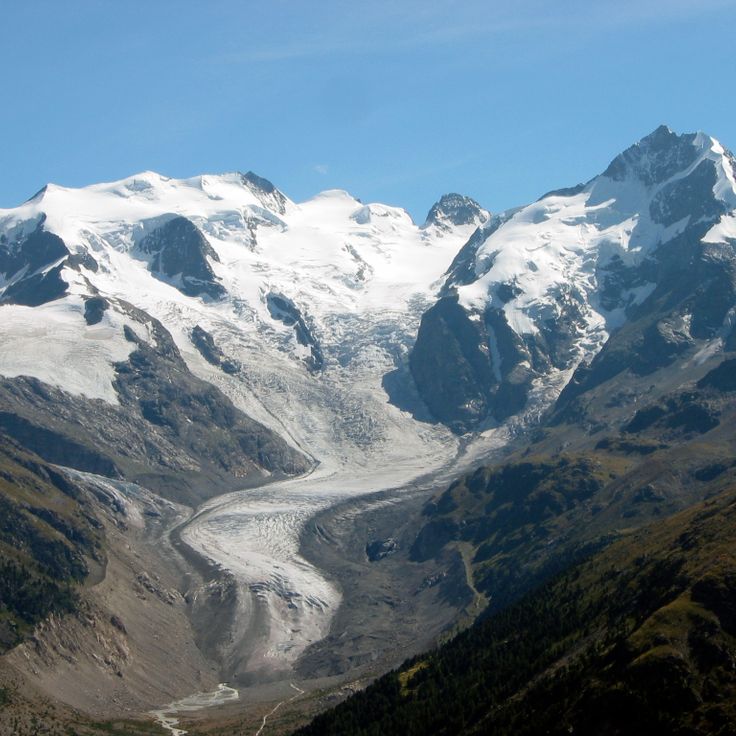
The Morteratsch Glacier extends over six kilometres in the Bernina Range and ranks among the largest glaciers in the Eastern Alps. This valley glacier sits at elevations between 2000 and 4000 metres and receives ice from several four-thousand-metre peaks, including Piz Bernina and Piz Palü. The glacier has been retreating continuously since the mid-19th century and loses an average of 30 metres in length annually. A marked hiking trail leads from Morteratsch railway station to the glacier tongue and documents the ice retreat over recent decades with informational signs.
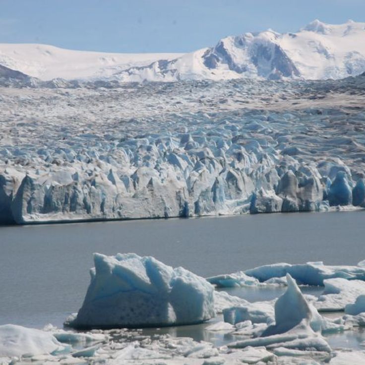
The Upsala Glacier extends 53 kilometers through the Patagonian Andes and ranks among the largest glaciers of the Southern Patagonian Ice Field. Its terminus regularly calves large ice blocks into Lake Argentino, resulting in ongoing retreat. The glacier forms part of a significant hydrological system for Patagonia together with other regional glaciers.
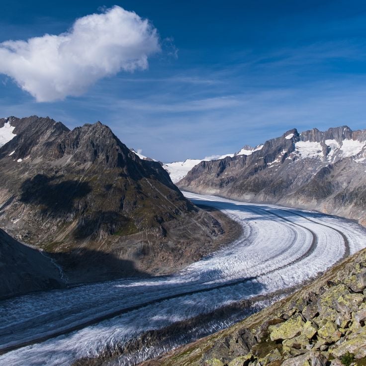
The Aletsch Glacier stretches for 23 kilometres through the Bernese Alps and forms the longest ice mass in the Alps. This glacier contains approximately 27 billion tonnes of ice and extends from the Jungfraujoch at 4000 metres altitude down to the Massa Gorge at 1560 metres. The area was designated a UNESCO World Heritage Site in 2001 and attracts numerous visitors annually who explore the glacier tongue and surrounding hiking trails.
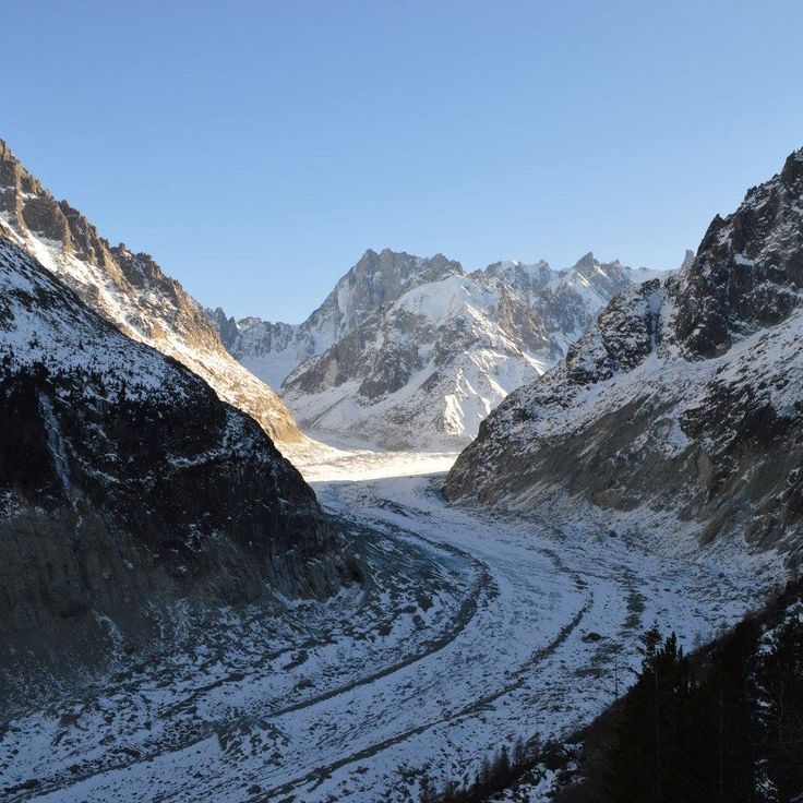
The Mer de Glace glacier at Chamonix-Mont-Blanc is a valley glacier in the French Alps. It forms when snow compresses over centuries and moves slowly downward through the valley. Like other major glaciers around the world, it stores fresh water and its changes provide evidence of how rising temperatures affect our climate.
Briksdalsbreen is a glacier arm in Stryn Municipality, Norway. It flows from Jostedalsbreen, the largest ice mass in continental Europe. This glacier shows how ice slowly moves through valleys and shapes the land. Visitors can see the white ice and hear the sounds of moving glaciers. Briksdalsbreen serves as a climate record, revealing through its changes how rising temperatures affect ice systems worldwide. Like many glaciers, it continuously loses mass, which impacts freshwater supplies and sea levels globally.
Margerie Glacier is a tidewater glacier in Glacier Bay, Alaska, where ice meets the ocean directly. This mass of ice moves steadily downward and regularly breaks apart, sending icebergs floating into the bay. Like the world's other major glaciers, it shows the effects of rising temperatures and contributes to changes in sea level. The sight of blue ice cliffs and the sound of crashing ice make this place a powerful reminder of how glaciers shape our world.
Grey Glacier sits within Torres del Paine National Park and ranks among the largest glaciers in the region. Its wide expanse of ice stretches across a broad valley, showing how ice reshapes landscapes over centuries. The glacier is part of a larger ice field and visibly recedes from year to year. Visitors can observe the ice masses and surrounding mountains from various hiking trails. Meltwater from the glacier feeds turquoise lakes that color the valley floor.
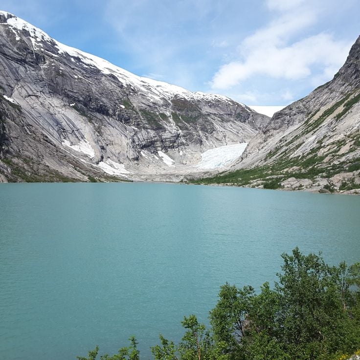
Nigardsbreen is a glacier in Luster Municipality, Norway, and forms part of the larger Jostedalsbreen ice field. This glacier shows how ice masses develop over centuries through snow accumulation and compression, then move slowly down through valleys. Nigardsbreen serves scientists as an important climate archive and demonstrates through its changes how rising temperatures affect the ice masses on Earth.
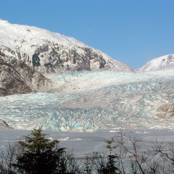
Mendenhall Glacier in Tongass National Forest, Alaska, is part of the world's glacial landscapes that shape our climate. This glacier demonstrates the effects of rising temperatures, just like many others on Earth. Its ice masses move slowly through the valley and have shaped the land over centuries. The glacier stores fresh water and contributes to the global water supply alongside all glacier masses. Visitors can observe here how this natural formation changes and what role it plays in Earth's climate system.
The Furtwängler Glacier is an alpine glacier on Mount Kilimanjaro in Tanzania. Like the other glaciers in this collection, this glacier shows the effects of rising temperatures on our planet. The glacier consists of ice masses that formed over centuries through the compression of snow. Such glaciers store fresh water and influence the water supply of the region. The Furtwängler Glacier documents climate changes like an archive and demonstrates through its changes how the Earth is warming.
Rhone Glacier is a valley glacier in the Swiss Alps that has taken thousands of years to form. Located near Gletsch in the Valais region, it shows clear signs of warming temperatures. Like many glaciers worldwide, Rhone Glacier is losing mass and retreating continuously. These changes affect the water supply of the region and contribute to rising sea levels. The glacier serves as a climate archive, with its ice cores revealing information about past temperature changes.
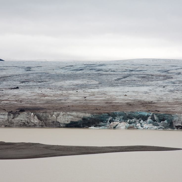
Langjökull is a glacier in southern Iceland that covers a vast area of the island. This ice cap is Iceland's second largest glacier and shapes the surrounding landscape through its slow movement. The glacier stores fresh water in its frozen form and contains a record of climate changes over centuries. Like glaciers worldwide, Langjökull loses mass each year, demonstrating how rising temperatures affect these natural formations.
The Biafo Glacier is located in the mountainous region of Gilgit-Baltistan in Pakistan. This massive glacier belongs to the great ice masses of the world that move slowly through valleys and across mountain slopes. Like other glaciers, the Biafo stores water and shapes the landscape around it. It demonstrates through its changes how rising temperatures affect the natural world.
The Fedtchenko Glacier is a vast expanse of ice in the Gorno-Badakhshan region of Tajikistan. This glacier is one of Earth's major natural ice formations, shaped over centuries as snow compacts and moves slowly through valleys and across mountain slopes. Like other significant glaciers, it plays a key role in storing fresh water and shaping the surrounding landscape. Scientists use glaciers such as this one to read records of past climate. The changes visible in this glacier demonstrate how rising temperatures affect these frozen masses.
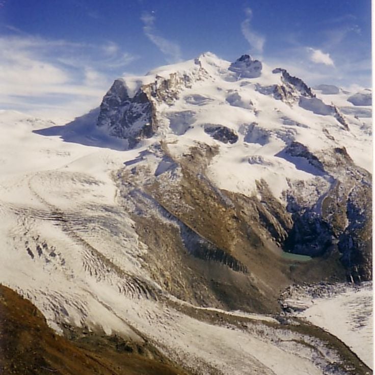
The Gorner glacier area in Switzerland shows how ice masses form over centuries and shape the landscape. This glacier serves science as an important archive of climate history and documents through its changes the effects of rising temperatures. The glacier moves slowly through the valley, molding the surrounding terrain. Like many glaciers worldwide, the Gorner glacier continuously loses mass, which affects water supply and sea levels.
Wrangell-St. Elias National Park, United States of America
The Malaspina Glacier is a vast glacier in Alaska formed where several mountain glaciers flow together and spread out into a flat plain. With its deep crevasses and striking blue ice, this glacier shows how ice masses move slowly across the landscape over thousands of years. As part of this collection of world glaciers, Malaspina serves as a record of past climates and demonstrates through its changes how rising temperatures affect our planet.
The Pastoruri in the White Cordillera is one of the easiest glaciers to reach in South America, located above 5000 meters high. Like other glaciers in this area, it clearly shows the effects of climate change, having lost a large part of its surface and thickness in recent decades. It is in a high mountain region with dry weather, and visitors can see how the ice has shaped the land over many years.
The Perito Moreno Glacier covers an area of 250 square kilometers and rises 74 meters above the water level of Lago Argentino. This glacier moves forward continuously at a rate of approximately two meters per day. This movement causes large masses of ice to regularly break off from the glacier wall and fall into the lake. The phenomenon occurs when the glacier forms a natural ice bridge that blocks the southern arm of the lake and eventually collapses under water pressure.
Jostedalsbreen covers 487 square kilometers and forms the largest ice cap on mainland Europe. This glacier sits between the mountains of Jostedalsbreen National Park and feeds 24 glacier tongues that descend into different valleys. The ice reaches depths of over 600 meters in places. Notable outlets include Briksdalsbreen and Nigardsbreen, both accessible for glacier hiking. The glacier forms through heavy snowfall at elevations between 1,200 and 2,000 meters.
Vatnajökull is the largest ice cap in Europe, covering 8100 square kilometers in eastern Iceland. Several active volcanoes lie beneath the ice sheet, including Grímsvötn and Bárðarbunga, which erupt regularly. The ice cap reaches thicknesses of up to 1000 meters in some areas. The glacier feeds numerous glacial rivers and forms ice caves that constantly change due to geothermal activity. The surrounding Vatnajökull National Park protects diverse landscapes, from glacier tongues to volcanic deserts.
The Glacier Bay is located in the southeast of Alaska and is home to seven active tidewater glaciers that flow directly into the sea. These glaciers calve regularly, producing icebergs of different sizes that drift in the bay's waters. The area covers about 13,000 square miles and has recorded glacier retreat since the late 1700s. The bay is a natural site for studying glacier activity and how plants and animals return after the ice moves back.
Fox Glacier extends 13 kilometers through a valley in the Southern Alps of New Zealand. The ice flows down from mountain slopes to an elevation of approximately 300 meters above sea level, where it terminates in temperate rainforest. The glacier moves at an average rate of one meter per day and forms ice caves and crevasses. Several walking tracks lead to viewing points where visitors can observe the ice formations and the glacial valley.
The Franz Josef Glacier extends 12 kilometers along the West Coast of New Zealand's South Island. This glacier moves at speeds of up to 4 meters per day, making it one of the fastest flowing glaciers in temperate regions. The Franz Josef Glacier originates in the Southern Alps at approximately 2700 meters elevation and descends to 240 meters above sea level. The glacier valley offers various walking tracks and guided tours that allow visitors to observe the ice formations up close.
The Pasterze Glacier extends over a length of 8.4 kilometers and covers an area of 19.5 square kilometers in the Hohe Tauern range. This glacier sits at the base of Grossglockner, Austria's highest mountain, and forms the largest ice field in the country. The glacier shows clear evidence of climate change with continuous reduction in its mass and extent since the 19th century. From the Franz-Josefs-Höhe viewpoint, visitors can observe the entire glacier basin and examine the ice formations and crevasses that characterize its surface.
The Jakobshavn Glacier is one of the most active glaciers in the world, advancing between 30 and 50 meters per day. It flows into the Ilulissat Icefjord on the western coast of Greenland and is responsible for producing approximately 10 percent of all icebergs that calve in Greenlandic waters. The glacier drains about 6.5 percent of the Greenland Ice Sheet and has experienced substantial mass loss in recent decades.
The Athabasca Glacier extends six kilometers from the Columbia Icefield into the valleys of the Canadian Rockies. This glacier tongue sits on the border between Alberta and British Columbia at elevations ranging from 2100 to 3500 meters. The glacier is accessible from the Icefields Parkway and loses approximately five meters in thickness each year due to rising temperatures. Scientific measurements have documented its continuous retreat since the 1840s.
The Siachen Glacier extends over 76 kilometers in length and sits at an elevation of 5,753 meters in the eastern Karakoram range. This glacier has formed the line of control between Indian and Pakistani administered territories for decades. The extreme weather conditions with temperatures dropping to minus 50 degrees Celsius make this location one of the most challenging military deployment sites in the world.
The Baltoro Glacier extends 63 kilometers through the Karakoram range and ranks among the longest glaciers outside polar regions. This glacier serves as the primary access route to four eight-thousanders, including K2 at 8,611 meters, the second highest mountain on Earth. The ice streams of the Baltoro are fed by numerous tributary glaciers and form the source of the Shigar River. Mountaineers and expeditions use the route along the glacier as a base for ascents to the surrounding peaks.
Hubbard Glacier extends 122 kilometers through the Saint Elias Mountains and demonstrates a phenomenon that has become rare worldwide: it advances approximately 24 meters each year. This mass gain contrasts with the global trend of glacier retreat. The glacier terminates at Disenchantment Bay and Yakutat Bay in Alaska. Its width reaches approximately 10 kilometers at the calving face, where large blocks of ice regularly break off into the ocean.
The Tasman Glacier extends for 23 kilometres through Aoraki Mount Cook National Park on New Zealand's South Island. This glacier sits at the base of Mount Cook, the country's highest peak, and flows down a valley between the mountain ranges of the Southern Alps. Since 1990, the Tasman Glacier has been retreating at a rate of approximately 180 metres per year due to glacial melting. At its widest point, the glacier measures about four kilometres across. The lower section of the glacier terminates in a glacial lake that has formed over recent decades as the ice melts. This lake continues to expand as the glacier retreats. Visitors can access the glacier area via walking tracks or take boat tours on the glacial lake to observe the floating icebergs that calve from the glacier face.
The Morteratsch Glacier extends over six kilometres in the Bernina Range and ranks among the largest glaciers in the Eastern Alps. This valley glacier sits at elevations between 2000 and 4000 metres and receives ice from several four-thousand-metre peaks, including Piz Bernina and Piz Palü. The glacier has been retreating continuously since the mid-19th century and loses an average of 30 metres in length annually. A marked hiking trail leads from Morteratsch railway station to the glacier tongue and documents the ice retreat over recent decades with informational signs.
The Upsala Glacier extends 53 kilometers through the Patagonian Andes and ranks among the largest glaciers of the Southern Patagonian Ice Field. Its terminus regularly calves large ice blocks into Lake Argentino, resulting in ongoing retreat. The glacier forms part of a significant hydrological system for Patagonia together with other regional glaciers.
The Aletsch Glacier stretches for 23 kilometres through the Bernese Alps and forms the longest ice mass in the Alps. This glacier contains approximately 27 billion tonnes of ice and extends from the Jungfraujoch at 4000 metres altitude down to the Massa Gorge at 1560 metres. The area was designated a UNESCO World Heritage Site in 2001 and attracts numerous visitors annually who explore the glacier tongue and surrounding hiking trails.
The Mer de Glace glacier at Chamonix-Mont-Blanc is a valley glacier in the French Alps. It forms when snow compresses over centuries and moves slowly downward through the valley. Like other major glaciers around the world, it stores fresh water and its changes provide evidence of how rising temperatures affect our climate.
Briksdalsbreen is a glacier arm in Stryn Municipality, Norway. It flows from Jostedalsbreen, the largest ice mass in continental Europe. This glacier shows how ice slowly moves through valleys and shapes the land. Visitors can see the white ice and hear the sounds of moving glaciers. Briksdalsbreen serves as a climate record, revealing through its changes how rising temperatures affect ice systems worldwide. Like many glaciers, it continuously loses mass, which impacts freshwater supplies and sea levels globally.
Margerie Glacier is a tidewater glacier in Glacier Bay, Alaska, where ice meets the ocean directly. This mass of ice moves steadily downward and regularly breaks apart, sending icebergs floating into the bay. Like the world's other major glaciers, it shows the effects of rising temperatures and contributes to changes in sea level. The sight of blue ice cliffs and the sound of crashing ice make this place a powerful reminder of how glaciers shape our world.
Grey Glacier sits within Torres del Paine National Park and ranks among the largest glaciers in the region. Its wide expanse of ice stretches across a broad valley, showing how ice reshapes landscapes over centuries. The glacier is part of a larger ice field and visibly recedes from year to year. Visitors can observe the ice masses and surrounding mountains from various hiking trails. Meltwater from the glacier feeds turquoise lakes that color the valley floor.
Nigardsbreen is a glacier in Luster Municipality, Norway, and forms part of the larger Jostedalsbreen ice field. This glacier shows how ice masses develop over centuries through snow accumulation and compression, then move slowly down through valleys. Nigardsbreen serves scientists as an important climate archive and demonstrates through its changes how rising temperatures affect the ice masses on Earth.
Mendenhall Glacier in Tongass National Forest, Alaska, is part of the world's glacial landscapes that shape our climate. This glacier demonstrates the effects of rising temperatures, just like many others on Earth. Its ice masses move slowly through the valley and have shaped the land over centuries. The glacier stores fresh water and contributes to the global water supply alongside all glacier masses. Visitors can observe here how this natural formation changes and what role it plays in Earth's climate system.
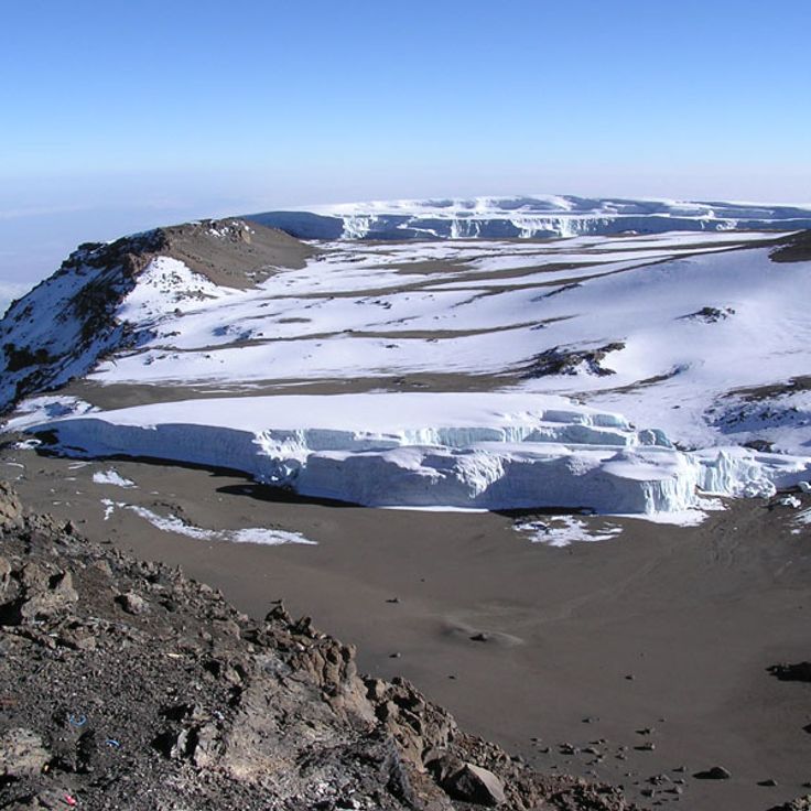
The Furtwängler Glacier is an alpine glacier on Mount Kilimanjaro in Tanzania. Like the other glaciers in this collection, this glacier shows the effects of rising temperatures on our planet. The glacier consists of ice masses that formed over centuries through the compression of snow. Such glaciers store fresh water and influence the water supply of the region. The Furtwängler Glacier documents climate changes like an archive and demonstrates through its changes how the Earth is warming.
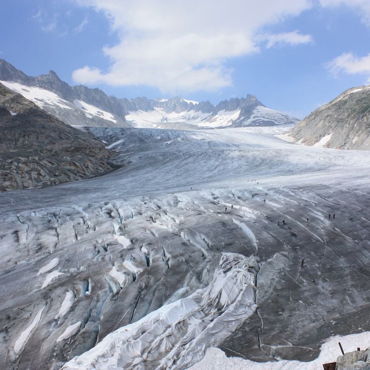
Rhone Glacier is a valley glacier in the Swiss Alps that has taken thousands of years to form. Located near Gletsch in the Valais region, it shows clear signs of warming temperatures. Like many glaciers worldwide, Rhone Glacier is losing mass and retreating continuously. These changes affect the water supply of the region and contribute to rising sea levels. The glacier serves as a climate archive, with its ice cores revealing information about past temperature changes.
Langjökull is a glacier in southern Iceland that covers a vast area of the island. This ice cap is Iceland's second largest glacier and shapes the surrounding landscape through its slow movement. The glacier stores fresh water in its frozen form and contains a record of climate changes over centuries. Like glaciers worldwide, Langjökull loses mass each year, demonstrating how rising temperatures affect these natural formations.
The Biafo Glacier is located in the mountainous region of Gilgit-Baltistan in Pakistan. This massive glacier belongs to the great ice masses of the world that move slowly through valleys and across mountain slopes. Like other glaciers, the Biafo stores water and shapes the landscape around it. It demonstrates through its changes how rising temperatures affect the natural world.
The Fedtchenko Glacier is a vast expanse of ice in the Gorno-Badakhshan region of Tajikistan. This glacier is one of Earth's major natural ice formations, shaped over centuries as snow compacts and moves slowly through valleys and across mountain slopes. Like other significant glaciers, it plays a key role in storing fresh water and shaping the surrounding landscape. Scientists use glaciers such as this one to read records of past climate. The changes visible in this glacier demonstrate how rising temperatures affect these frozen masses.
The Gorner glacier area in Switzerland shows how ice masses form over centuries and shape the landscape. This glacier serves science as an important archive of climate history and documents through its changes the effects of rising temperatures. The glacier moves slowly through the valley, molding the surrounding terrain. Like many glaciers worldwide, the Gorner glacier continuously loses mass, which affects water supply and sea levels.
Wrangell-St. Elias National Park, United States of America
The Malaspina Glacier is a vast glacier in Alaska formed where several mountain glaciers flow together and spread out into a flat plain. With its deep crevasses and striking blue ice, this glacier shows how ice masses move slowly across the landscape over thousands of years. As part of this collection of world glaciers, Malaspina serves as a record of past climates and demonstrates through its changes how rising temperatures affect our planet.
The Pastoruri in the White Cordillera is one of the easiest glaciers to reach in South America, located above 5000 meters high. Like other glaciers in this area, it clearly shows the effects of climate change, having lost a large part of its surface and thickness in recent decades. It is in a high mountain region with dry weather, and visitors can see how the ice has shaped the land over many years.
The Perito Moreno Glacier covers an area of 250 square kilometers and rises 74 meters above the water level of Lago Argentino. This glacier moves forward continuously at a rate of approximately two meters per day. This movement causes large masses of ice to regularly break off from the glacier wall and fall into the lake. The phenomenon occurs when the glacier forms a natural ice bridge that blocks the southern arm of the lake and eventually collapses under water pressure.
Jostedalsbreen covers 487 square kilometers and forms the largest ice cap on mainland Europe. This glacier sits between the mountains of Jostedalsbreen National Park and feeds 24 glacier tongues that descend into different valleys. The ice reaches depths of over 600 meters in places. Notable outlets include Briksdalsbreen and Nigardsbreen, both accessible for glacier hiking. The glacier forms through heavy snowfall at elevations between 1,200 and 2,000 meters.
Vatnajökull is the largest ice cap in Europe, covering 8100 square kilometers in eastern Iceland. Several active volcanoes lie beneath the ice sheet, including Grímsvötn and Bárðarbunga, which erupt regularly. The ice cap reaches thicknesses of up to 1000 meters in some areas. The glacier feeds numerous glacial rivers and forms ice caves that constantly change due to geothermal activity. The surrounding Vatnajökull National Park protects diverse landscapes, from glacier tongues to volcanic deserts.
The Glacier Bay is located in the southeast of Alaska and is home to seven active tidewater glaciers that flow directly into the sea. These glaciers calve regularly, producing icebergs of different sizes that drift in the bay's waters. The area covers about 13,000 square miles and has recorded glacier retreat since the late 1700s. The bay is a natural site for studying glacier activity and how plants and animals return after the ice moves back.
Fox Glacier extends 13 kilometers through a valley in the Southern Alps of New Zealand. The ice flows down from mountain slopes to an elevation of approximately 300 meters above sea level, where it terminates in temperate rainforest. The glacier moves at an average rate of one meter per day and forms ice caves and crevasses. Several walking tracks lead to viewing points where visitors can observe the ice formations and the glacial valley.
The Franz Josef Glacier extends 12 kilometers along the West Coast of New Zealand's South Island. This glacier moves at speeds of up to 4 meters per day, making it one of the fastest flowing glaciers in temperate regions. The Franz Josef Glacier originates in the Southern Alps at approximately 2700 meters elevation and descends to 240 meters above sea level. The glacier valley offers various walking tracks and guided tours that allow visitors to observe the ice formations up close.
The Pasterze Glacier extends over a length of 8.4 kilometers and covers an area of 19.5 square kilometers in the Hohe Tauern range. This glacier sits at the base of Grossglockner, Austria's highest mountain, and forms the largest ice field in the country. The glacier shows clear evidence of climate change with continuous reduction in its mass and extent since the 19th century. From the Franz-Josefs-Höhe viewpoint, visitors can observe the entire glacier basin and examine the ice formations and crevasses that characterize its surface.
The Jakobshavn Glacier is one of the most active glaciers in the world, advancing between 30 and 50 meters per day. It flows into the Ilulissat Icefjord on the western coast of Greenland and is responsible for producing approximately 10 percent of all icebergs that calve in Greenlandic waters. The glacier drains about 6.5 percent of the Greenland Ice Sheet and has experienced substantial mass loss in recent decades.
The Athabasca Glacier extends six kilometers from the Columbia Icefield into the valleys of the Canadian Rockies. This glacier tongue sits on the border between Alberta and British Columbia at elevations ranging from 2100 to 3500 meters. The glacier is accessible from the Icefields Parkway and loses approximately five meters in thickness each year due to rising temperatures. Scientific measurements have documented its continuous retreat since the 1840s.
The Siachen Glacier extends over 76 kilometers in length and sits at an elevation of 5,753 meters in the eastern Karakoram range. This glacier has formed the line of control between Indian and Pakistani administered territories for decades. The extreme weather conditions with temperatures dropping to minus 50 degrees Celsius make this location one of the most challenging military deployment sites in the world.
The Baltoro Glacier extends 63 kilometers through the Karakoram range and ranks among the longest glaciers outside polar regions. This glacier serves as the primary access route to four eight-thousanders, including K2 at 8,611 meters, the second highest mountain on Earth. The ice streams of the Baltoro are fed by numerous tributary glaciers and form the source of the Shigar River. Mountaineers and expeditions use the route along the glacier as a base for ascents to the surrounding peaks.
Hubbard Glacier extends 122 kilometers through the Saint Elias Mountains and demonstrates a phenomenon that has become rare worldwide: it advances approximately 24 meters each year. This mass gain contrasts with the global trend of glacier retreat. The glacier terminates at Disenchantment Bay and Yakutat Bay in Alaska. Its width reaches approximately 10 kilometers at the calving face, where large blocks of ice regularly break off into the ocean.
The Tasman Glacier extends for 23 kilometres through Aoraki Mount Cook National Park on New Zealand's South Island. This glacier sits at the base of Mount Cook, the country's highest peak, and flows down a valley between the mountain ranges of the Southern Alps. Since 1990, the Tasman Glacier has been retreating at a rate of approximately 180 metres per year due to glacial melting. At its widest point, the glacier measures about four kilometres across. The lower section of the glacier terminates in a glacial lake that has formed over recent decades as the ice melts. This lake continues to expand as the glacier retreats. Visitors can access the glacier area via walking tracks or take boat tours on the glacial lake to observe the floating icebergs that calve from the glacier face.
The Morteratsch Glacier extends over six kilometres in the Bernina Range and ranks among the largest glaciers in the Eastern Alps. This valley glacier sits at elevations between 2000 and 4000 metres and receives ice from several four-thousand-metre peaks, including Piz Bernina and Piz Palü. The glacier has been retreating continuously since the mid-19th century and loses an average of 30 metres in length annually. A marked hiking trail leads from Morteratsch railway station to the glacier tongue and documents the ice retreat over recent decades with informational signs.
The Upsala Glacier extends 53 kilometers through the Patagonian Andes and ranks among the largest glaciers of the Southern Patagonian Ice Field. Its terminus regularly calves large ice blocks into Lake Argentino, resulting in ongoing retreat. The glacier forms part of a significant hydrological system for Patagonia together with other regional glaciers.
The Aletsch Glacier stretches for 23 kilometres through the Bernese Alps and forms the longest ice mass in the Alps. This glacier contains approximately 27 billion tonnes of ice and extends from the Jungfraujoch at 4000 metres altitude down to the Massa Gorge at 1560 metres. The area was designated a UNESCO World Heritage Site in 2001 and attracts numerous visitors annually who explore the glacier tongue and surrounding hiking trails.
The Mer de Glace glacier at Chamonix-Mont-Blanc is a valley glacier in the French Alps. It forms when snow compresses over centuries and moves slowly downward through the valley. Like other major glaciers around the world, it stores fresh water and its changes provide evidence of how rising temperatures affect our climate.
Briksdalsbreen is a glacier arm in Stryn Municipality, Norway. It flows from Jostedalsbreen, the largest ice mass in continental Europe. This glacier shows how ice slowly moves through valleys and shapes the land. Visitors can see the white ice and hear the sounds of moving glaciers. Briksdalsbreen serves as a climate record, revealing through its changes how rising temperatures affect ice systems worldwide. Like many glaciers, it continuously loses mass, which impacts freshwater supplies and sea levels globally.
Margerie Glacier is a tidewater glacier in Glacier Bay, Alaska, where ice meets the ocean directly. This mass of ice moves steadily downward and regularly breaks apart, sending icebergs floating into the bay. Like the world's other major glaciers, it shows the effects of rising temperatures and contributes to changes in sea level. The sight of blue ice cliffs and the sound of crashing ice make this place a powerful reminder of how glaciers shape our world.
Grey Glacier sits within Torres del Paine National Park and ranks among the largest glaciers in the region. Its wide expanse of ice stretches across a broad valley, showing how ice reshapes landscapes over centuries. The glacier is part of a larger ice field and visibly recedes from year to year. Visitors can observe the ice masses and surrounding mountains from various hiking trails. Meltwater from the glacier feeds turquoise lakes that color the valley floor.
Nigardsbreen is a glacier in Luster Municipality, Norway, and forms part of the larger Jostedalsbreen ice field. This glacier shows how ice masses develop over centuries through snow accumulation and compression, then move slowly down through valleys. Nigardsbreen serves scientists as an important climate archive and demonstrates through its changes how rising temperatures affect the ice masses on Earth.
Mendenhall Glacier in Tongass National Forest, Alaska, is part of the world's glacial landscapes that shape our climate. This glacier demonstrates the effects of rising temperatures, just like many others on Earth. Its ice masses move slowly through the valley and have shaped the land over centuries. The glacier stores fresh water and contributes to the global water supply alongside all glacier masses. Visitors can observe here how this natural formation changes and what role it plays in Earth's climate system.
The Furtwängler Glacier is an alpine glacier on Mount Kilimanjaro in Tanzania. Like the other glaciers in this collection, this glacier shows the effects of rising temperatures on our planet. The glacier consists of ice masses that formed over centuries through the compression of snow. Such glaciers store fresh water and influence the water supply of the region. The Furtwängler Glacier documents climate changes like an archive and demonstrates through its changes how the Earth is warming.
Rhone Glacier is a valley glacier in the Swiss Alps that has taken thousands of years to form. Located near Gletsch in the Valais region, it shows clear signs of warming temperatures. Like many glaciers worldwide, Rhone Glacier is losing mass and retreating continuously. These changes affect the water supply of the region and contribute to rising sea levels. The glacier serves as a climate archive, with its ice cores revealing information about past temperature changes.
Langjökull is a glacier in southern Iceland that covers a vast area of the island. This ice cap is Iceland's second largest glacier and shapes the surrounding landscape through its slow movement. The glacier stores fresh water in its frozen form and contains a record of climate changes over centuries. Like glaciers worldwide, Langjökull loses mass each year, demonstrating how rising temperatures affect these natural formations.
The Biafo Glacier is located in the mountainous region of Gilgit-Baltistan in Pakistan. This massive glacier belongs to the great ice masses of the world that move slowly through valleys and across mountain slopes. Like other glaciers, the Biafo stores water and shapes the landscape around it. It demonstrates through its changes how rising temperatures affect the natural world.
The Fedtchenko Glacier is a vast expanse of ice in the Gorno-Badakhshan region of Tajikistan. This glacier is one of Earth's major natural ice formations, shaped over centuries as snow compacts and moves slowly through valleys and across mountain slopes. Like other significant glaciers, it plays a key role in storing fresh water and shaping the surrounding landscape. Scientists use glaciers such as this one to read records of past climate. The changes visible in this glacier demonstrate how rising temperatures affect these frozen masses.
The Gorner glacier area in Switzerland shows how ice masses form over centuries and shape the landscape. This glacier serves science as an important archive of climate history and documents through its changes the effects of rising temperatures. The glacier moves slowly through the valley, molding the surrounding terrain. Like many glaciers worldwide, the Gorner glacier continuously loses mass, which affects water supply and sea levels.
Wrangell-St. Elias National Park, United States of America
The Malaspina Glacier is a vast glacier in Alaska formed where several mountain glaciers flow together and spread out into a flat plain. With its deep crevasses and striking blue ice, this glacier shows how ice masses move slowly across the landscape over thousands of years. As part of this collection of world glaciers, Malaspina serves as a record of past climates and demonstrates through its changes how rising temperatures affect our planet.
The Pastoruri in the White Cordillera is one of the easiest glaciers to reach in South America, located above 5000 meters high. Like other glaciers in this area, it clearly shows the effects of climate change, having lost a large part of its surface and thickness in recent decades. It is in a high mountain region with dry weather, and visitors can see how the ice has shaped the land over many years.
If you plan to visit one of these glaciers, get ready for unpredictable weather. The best times vary by region: summer in the south for Patagonia, summer in the north for Norway and Iceland. Bring warm and waterproof clothes, as the weather can change quickly in the mountains.