See the monuments around you in AROpen chests in the app
Around Us is built for your phone — point your camera at the streets and discover the monuments and places around you in augmented reality.Around Us is built for your phone — chests unlock when you walk, explore and capture nearby places.
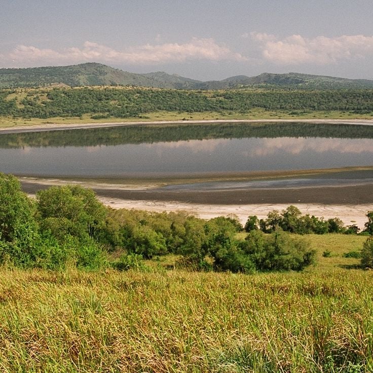
Uganda sits at the heart of East Africa, where dense tropical forests meet open savanna and the Nile River begins its long journey north. The landscape rises from the shores of Lake Victoria through rolling green hills to mountain ranges that touch over 5,000 meters, high enough to hold glaciers just kilometers from the equator. National parks protect rare mountain gorillas in the mist-covered highlands of Bwindi and Mgahinga, while chimpanzees move through the canopy of Kibale Forest. The Murchison Falls compress the full force of the Nile into a narrow gorge, and Lake Bunyonyi spreads across dozens of small islands where villages perch on terraced hillsides.
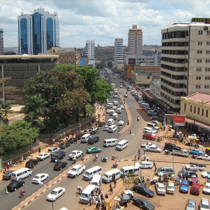
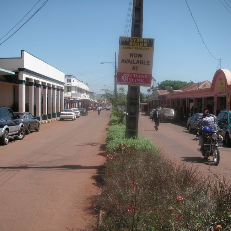
Kampala, the capital, climbs across seven hills in the center of the country, where markets, temples, and modern buildings share space in a city of one and a half million people. To the east, Jinja marks the place where the White Nile leaves Lake Victoria, now a base for rafting and boat trips. Entebbe rests on a peninsula jutting into the lake, quieter than the capital, with old botanical gardens and tree-lined streets. Between these cities and the parks, travelers find royal tombs, ancient rock art, and small trading towns that connect the country from the wetlands of the west to the drier plains near Kenya.
Uganda sits at the heart of East Africa, where dense tropical forests meet open savanna and the Nile River begins its long journey north. The landscape rises from the shores of Lake Victoria through rolling green hills to mountain ranges that touch over 5,000 meters, high enough to hold glaciers just kilometers from the equator. National parks protect rare mountain gorillas in the mist-covered highlands of Bwindi and Mgahinga, while chimpanzees move through the canopy of Kibale Forest. The Murchison Falls compress the full force of the Nile into a narrow gorge, and Lake Bunyonyi spreads across dozens of small islands where villages perch on terraced hillsides.
Kampala, the capital, climbs across seven hills in the center of the country, where markets, temples, and modern buildings share space in a city of one and a half million people. To the east, Jinja marks the place where the White Nile leaves Lake Victoria, now a base for rafting and boat trips. Entebbe rests on a peninsula jutting into the lake, quieter than the capital, with old botanical gardens and tree-lined streets. Between these cities and the parks, travelers find royal tombs, ancient rock art, and small trading towns that connect the country from the wetlands of the west to the drier plains near Kenya.
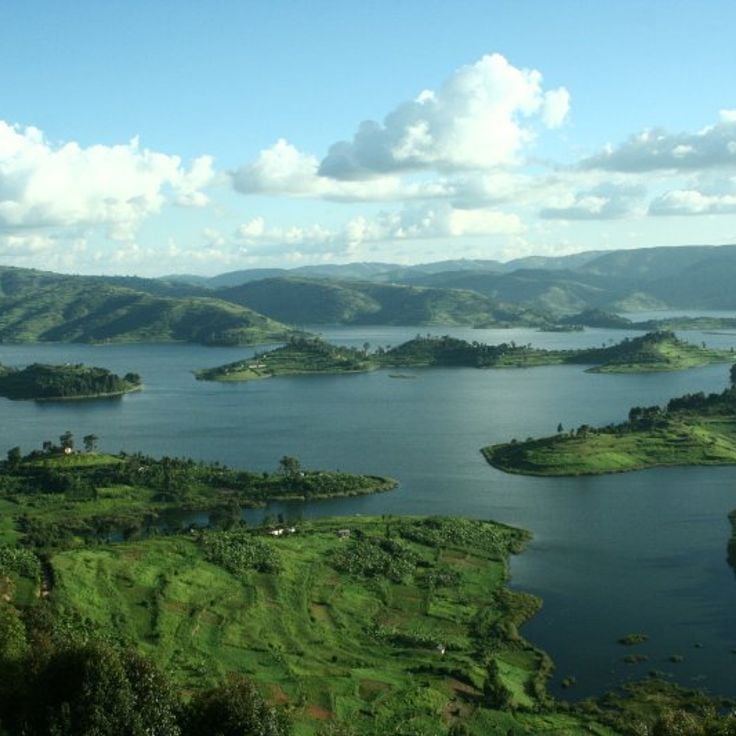
This lake lies in the hills of Southwest Uganda, nearly 6,200 feet (1,900 meters) above sea level, surrounded by slopes covered in terraced farms that climb toward the ridges. The water of Lake Bunyonyi spreads across twenty-nine islands of different sizes, some inhabited, others thick with trees and reeds. Villages sit along the shores and on the larger islands, where people grow vegetables and grains on narrow plots that follow the steep hillsides. Small wooden boats and dugout canoes connect the settlements, and fishermen paddle out in the early morning when the surface is calm. Many bird species nest in the vegetation near the water and call from the trees at sunrise. The lake itself is deep and clear, held in a landscape shaped by farming over many generations.
This national park sits at the far southwest corner of the country, where Uganda meets Rwanda and the Democratic Republic of Congo. The landscape climbs steeply from valleys to the slopes of three volcanoes, their summits rising through cloud forest and alpine moorland. Mountain gorillas move through the dense forest, and golden monkeys travel in the branches of the higher slopes. Trails lead upward to craters and rocky ridges that look out over three countries at once. The Batwa people, who once lived in these mountains, guide visitors along their former paths, showing caves and gathering places from earlier times.
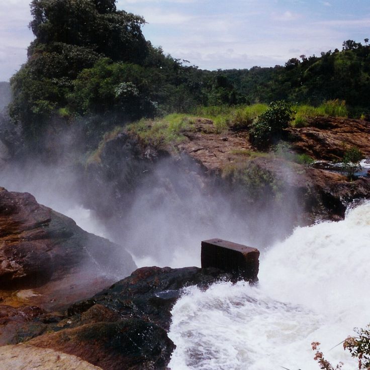
This waterfall sits in northwestern Uganda, where the Nile forces itself through a narrow gorge and drops into the depths below. The water thunders through a tight opening barely seven meters (23 feet) wide, falling more than 40 meters (130 feet). The river, which flows broad and calm upstream, gets compressed here with enormous force. From lookout points visitors can watch the water shoot through the rock gap, throwing up spray and filling the air with constant noise. The surrounding national park protects elephants, giraffes, and hippos that gather along the riverbanks.
This national park lies in western Uganda between two large lakes and spreads across open grassland, acacia woodland, and papyrus swamps. Lions occasionally climb into fig trees, elephants move in herds across the wide plains, and along the shores of the Kazinga Channel hippos and crocodiles gather in large numbers. The park slopes down to the water, where pelicans and other water birds fish at the shallow edges. Morning game drives pass through the grassland where antelopes and buffalo graze, while boat trips on the channel bring views of elephants drinking and hippos bathing.
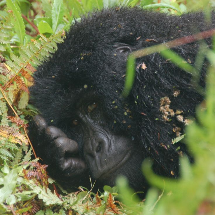
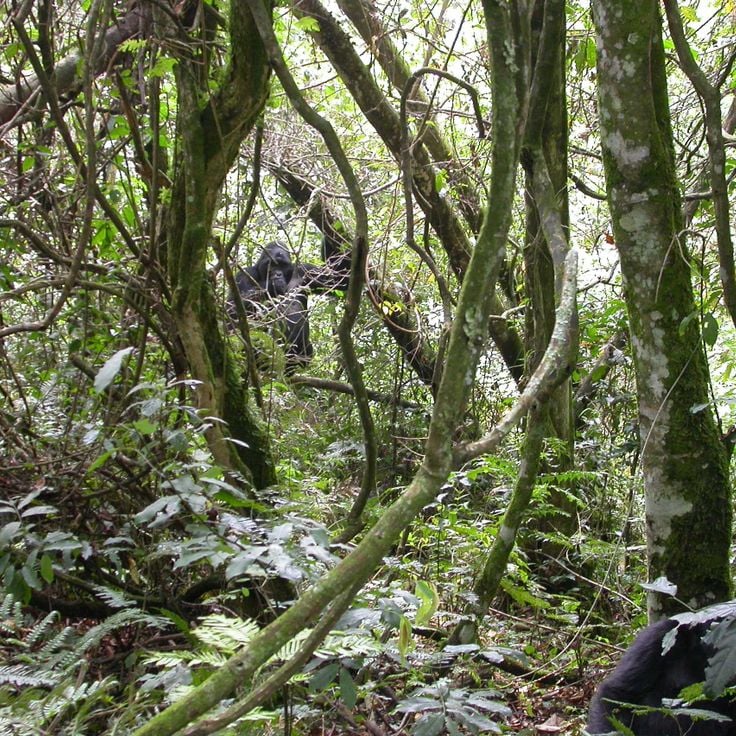
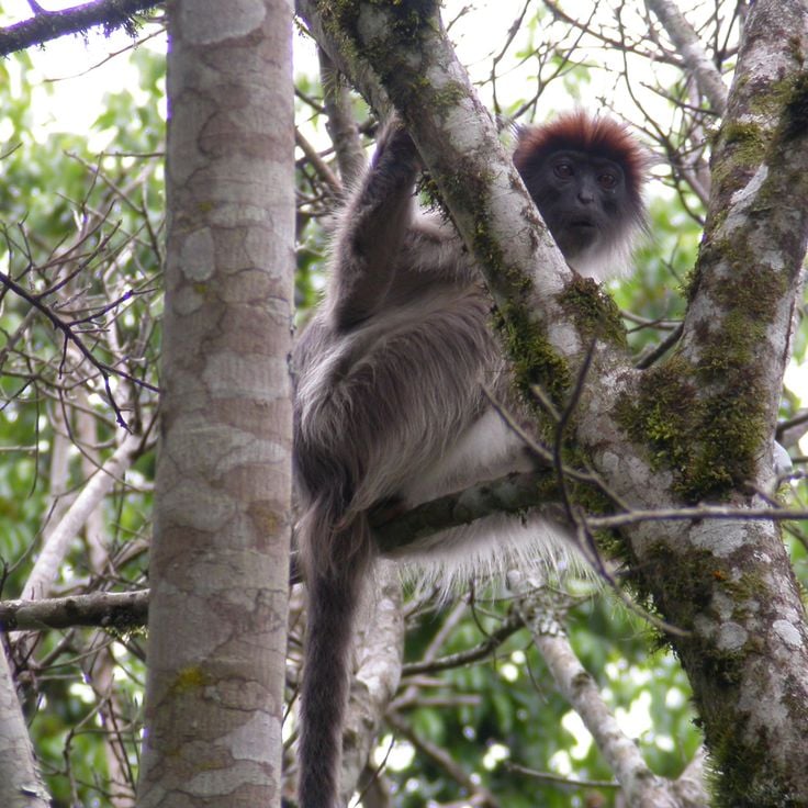
This national park protects dense mountain rainforest in the southwest, home to nearly half of all living mountain gorillas. The mist-covered slopes rise between 3,800 and 8,500 feet (1,160 and 2,600 meters), covered in old-growth forest where ferns, mosses, and tall trees grow. Narrow trails lead through the undergrowth to spots where gorilla families feed and rest. Mornings start early, treks often last several hours before trackers locate the animals. The forest also shelters chimpanzees, forest elephants, and colobus monkeys. Over 350 bird species live here, many found only in these mountains. The terrain is steep and slippery, the air damp and cool. Villages sit at the park edge, where people farm the land and work as guides.
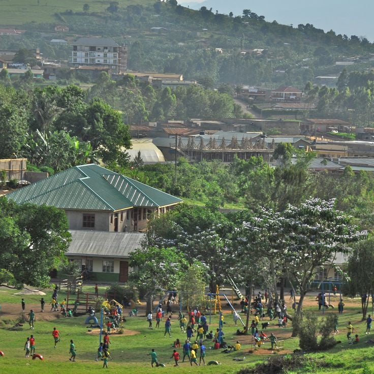
This city spreads across several hills at the heart of Uganda, forming the country's busy center. Street markets fill the steep lanes between modern buildings, while motorcycle taxis weave through dense traffic. Mosques and cathedrals mark different neighborhoods in this city of one and a half million people, where traders sell fruit and cloth under colorful tarps. From the hilltops you can see the red tile roofs and corrugated houses running to the horizon, with Lake Victoria glinting in the distance.
This national park covers dense rainforest in western Uganda and protects thirteen primate species. Chimpanzees live here in large numbers among tall trees and thick undergrowth. Walking trails lead through the forest, where groups of monkeys move through the canopy and calls echo between the trunks. Light filters down through the closed leaf cover, and the ground stays damp under moss and ferns. Butterflies hover over small clearings, and birds nest in the upper stories of the forest. The park connects highland and lowland terrain, showing the variety of tropical ecosystems between the lakes and mountains of the region.
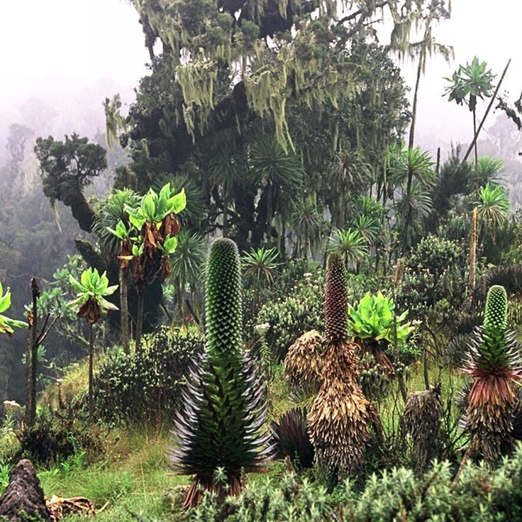
This mountain range rises along the border with Congo, where forested slopes climb through bamboo groves and alpine meadows to peaks that carry snow and glaciers. The highest point, Margherita Peak, reaches 5,109 meters (16,763 feet). Trails lead through several climate zones, from wet rainforest to heath and bog, then to bare rock near the summits. Mist and rain wrap the slopes almost daily, and streams pour from the rock into steep valleys. The Rwenzori Mountains remain one of the wettest high ranges in Africa, and a national park protects rare plants and animals on these slopes.
Jinja sits where the White Nile leaves Lake Victoria and begins its long journey north. This river town serves as the starting point for rafting trips through rapids and boat excursions upstream to the place where the water leaves the lake. The waterfront shows old colonial buildings beside newer hotels, and local markets extend through streets back from the river. Fishermen land their catches here, and small workshops repair boats along the shore. The surrounding area connects the river to green hills and villages that line the roads leading to Kampala and the lake.
Entebbe sits on a peninsula reaching into Lake Victoria, about forty kilometers southwest of Kampala. This town served as the administrative seat during British colonial rule and today keeps a quieter rhythm than the capital. Wide streets run through residential neighborhoods lined with old trees that give shade and soften the heat. The international airport connects the country to the rest of Africa and beyond. Along the lakeshore, the botanical gardens stretch out, planted in the late nineteenth century, where visitors walk among tropical plants and watch monkeys move through the canopy above. The nearness to water shapes daily life, and small fishing boats return each morning with their catch. Entebbe often serves as the first or last stop for travelers heading to Uganda's national parks and natural areas, offering a gentle shift between the bustle of the city and the quieter landscapes further inland.
This island group in Lake Victoria includes 84 separate islands scattered across the northwestern shore of the lake. Palms grow at the edge of sandy beaches, while inland dense rainforest covers the hills. Fishing boats pull up to small jetties where villages sit along the shorelines. Paths lead through the green to quiet coves, and waterbirds gather where shallow waters meet the land. The islands lie about two hours by ferry from Entebbe and keep a rhythm shaped by the water and the seasons.
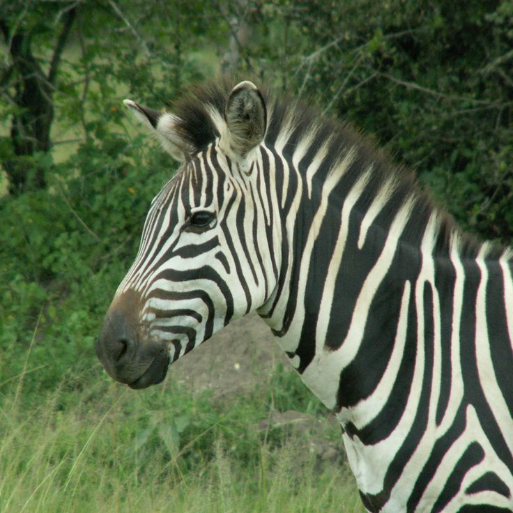
This national park spreads across rolling grassland, acacia woodland, and shallow lakes where hippos and crocodiles rest in the water. Zebras graze on open plains while impalas and topis move in herds. Warthogs root through the soil, and leopards prowl the bush after dark. Over 300 bird species live among the papyrus and shoreline vegetation. Walking trails lead through scrubland, and boat trips bring visitors close to the banks where herons and kingfishers perch on branches, waiting for fish.
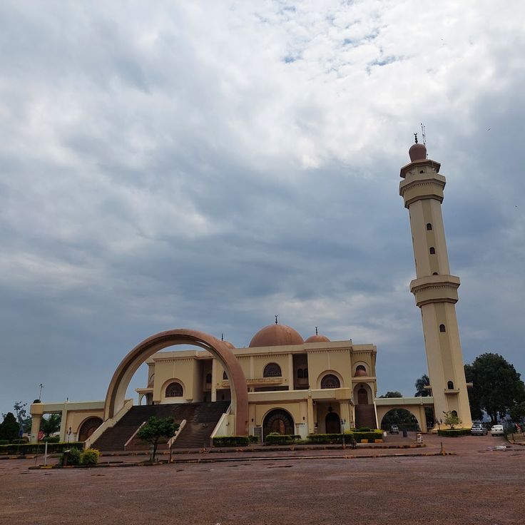
This mosque stands on a hill northeast of central Kampala, combining architectural elements from the Arab world with African building traditions. The main prayer hall holds thousands of worshipers, and the minaret rises about 200 feet (60 meters) above the surrounding residential neighborhoods. From the upper viewing platform, you see the rooftops of the city, the green hills that encircle it, and on clear days the expanse of Lake Victoria in the distance. The dome and white walls stand out against the trees, and the courtyard is lined with arcades. The mosque was completed in the early 2000s and is one of the largest in East Africa.
These botanical gardens spread across forty hectares along the shore of Lake Victoria and were laid out at the beginning of the twentieth century. Tall trees shelter more than three hundred plant species from tropical regions, while monkeys move through the branches and birds call from the canopy. Wide paths lead through forest sections and open lawns down to the water, where fishermen moor their boats. The gardens lie just a few kilometers from the center of Entebbe and serve as a quiet place to walk among the old trees.
This center offers the chance to see lions, leopards, giraffes, and other animals from Uganda in a natural setting while working on research and education programs for wildlife protection.
Ngamba Island sits in Lake Victoria, roughly 14 miles southeast of Entebbe, and provides a home to more than 50 chimpanzees rescued from illegal trade or after injury. The island extends across wooded terrain where the animals live in a protected area that allows access to trees, open patches, and natural vegetation. Twice daily, visitors arrive for feedings when chimpanzees gather at the forest edge and caretakers distribute fruit and vegetables. From a raised viewing area, you watch the animals climb, play, and interact while staff share information on the life story of each chimpanzee and on conservation efforts across Uganda. Most guests reach the island by boat from Entebbe, a journey of about 45 minutes across the open water of the lake. The island functions both as a sanctuary and an education center, communicating the importance of primate research and the problems of wildlife trafficking.
This town sits at 1,500 meters (4,900 feet) elevation in the western region, surrounded by tea plantations that stretch across the gentle slopes. Fort Portal serves as a starting point for trips to the volcanic crater lakes and the snow-capped peaks of the Rwenzori Mountains rising to the west. The streets pass through an area where tea is harvested, and the air is cooler than in the lower-lying cities. Travelers stop here before continuing to the national parks or exploring the lakes scattered around the surrounding countryside.
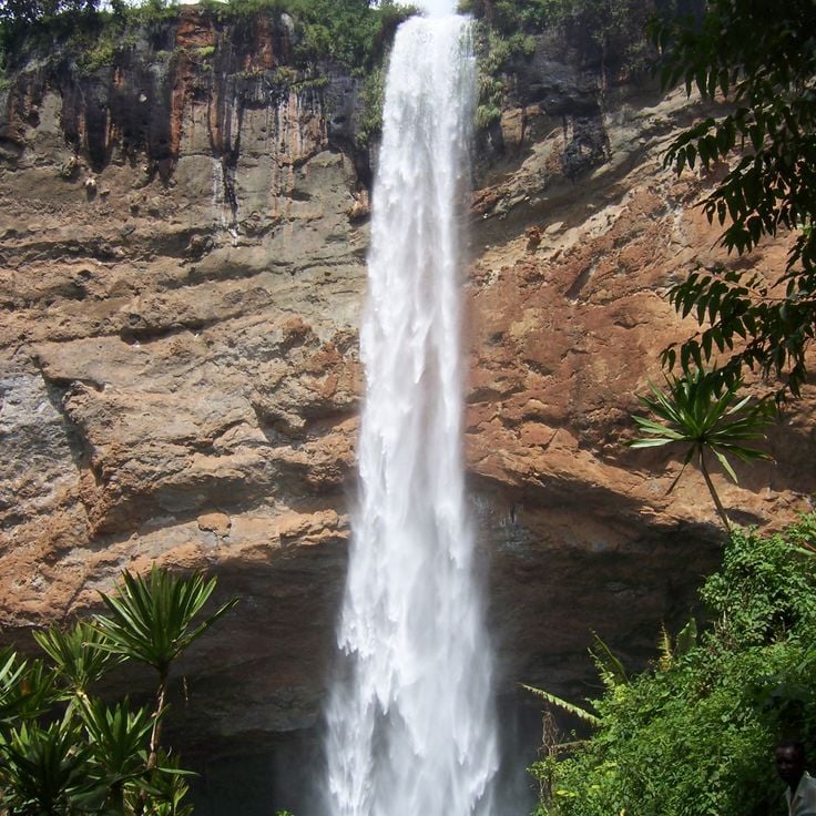
These falls lie on the slopes of Mount Elgon, where three stages drop one after another over rock walls. The highest fall slides about one hundred meters (three hundred feet) down, surrounded by coffee fields that stretch across the green hills. Walking trails lead from one stage to the next through thick vegetation, past banana plants and wild flowers. The water comes from the upper reaches of the mountain and tumbles into clear pools carved into the rock. Sabiny villages sit scattered across the slopes, where families grow coffee and use the cool climate of the higher ground. Morning mist often hangs between the trees before the sun breaks through and reveals rainbows in the spray.
This national park sits in the far northeast of the country, enclosed by mountain ranges along the borders with South Sudan and Kenya. The plains spread between the hills, covered in dry grassland and scattered thorn trees that provide shade for antelope and buffalo. Lions rest in the tall grass while elephants move toward the few water sources. Zebras travel in herds across the open ground. The landscape changes with the seasons: after the rains the valleys turn green, and in the dry months they fade to gold and brown. This park is among the most remote protected areas in Uganda and sees fewer visitors than the forests in the west.
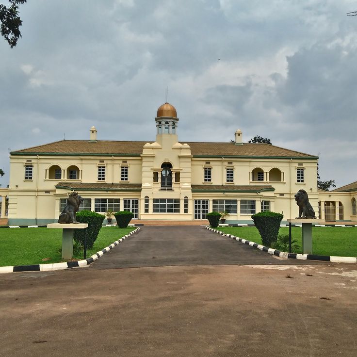
This palace on Mengo Hill served as the residence of the Kabaka, the traditional ruler of the Kingdom of Buganda, since 1922. The compound blends colonial architecture with local building traditions and displays ceremonial rooms where royal receptions and councils took place. Wide gardens and courtyards surround the main structure, now accessible as a museum that offers insight into Buganda monarchy history. Visitors see thrones, robes, and photographs tracing centuries of royal rule. From the hill, views open over Kampala and the surrounding hills of the capital.
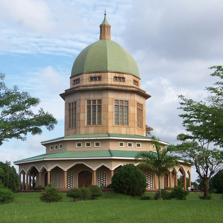
This temple stands on Kikaya Hill in Kampala, marked by its white dome that rises above the surrounding city. From up here you can look in all directions and see the rooftops, roads, and green spaces of Uganda's capital spread out below. The building serves as a place for prayer and reflection in the Bahá'í community.
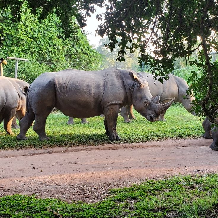
This sanctuary was established in 2005 to breed and protect white rhinos after they had disappeared from Uganda. The area covers woodland slopes and open grassland where small herds graze and rest in the shade. Visitors walk on foot with rangers through the vegetation, approaching the animals slowly and observing their behavior and movements. Alongside the rhinos, antelopes, monkeys, and many bird species live in the restored savanna landscape between Kampala and the northern parks.
This wetland reserve in western Uganda runs for eight kilometers through low-lying ground where papyrus and reeds grow over slow-moving water. Black-and-white colobus monkeys and mangabeys move through the canopy, while more than two hundred bird species live among the marsh vegetation. Wooden walkways lead visitors through the sanctuary, where water pools between the roots and the greenery presses close to the path. The reserve sits near Kibale Forest and is managed by local communities who offer guided walks through the landscape.
These rock shelters sit in the eastern region of the country, not far from the town of Kumi. Six rock faces carry geometric figures in red and white, painted between 1000 and 1500 BC. The motifs show circles, lines, and concentric forms whose exact meaning remains unknown. Archaeologists connect them to early inhabitants of the region, long before the present communities. The site lies quietly, surrounded by low scrub and rocks that provide shade. Visitors walk between the overhangs and view the paintings up close, protected by natural ledges that have preserved them over thousands of years.
This gorge cuts one hundred meters (330 feet) deep into the landscape of Queen Elizabeth National Park, its steep walls covered with rainforest. Chimpanzees live in the trees and on the ground, and guided walks follow the calls and movements of these animals through the undergrowth. Light falls in strips through the canopy, and ferns grow along the damp slopes. Paths lead down into the gorge where the air becomes cooler and streams flow between the roots. Kyambura Gorge shows a different side of the park, which is otherwise known for open savanna.
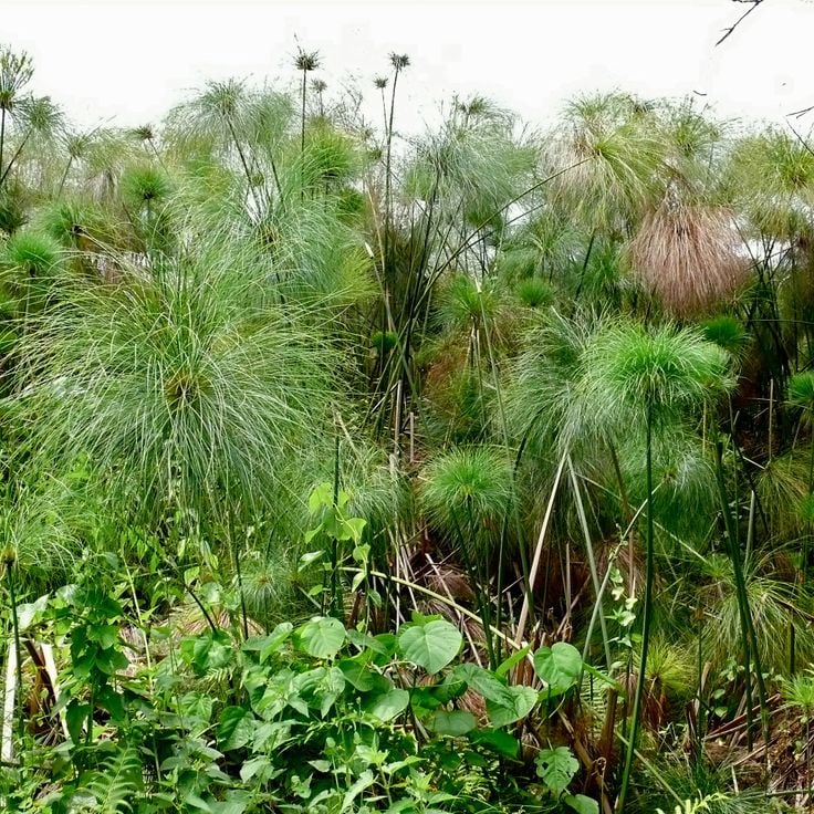
This swamp spreads across the western shore of Lake Victoria, where shallow water flows between tall stands of papyrus. The area is known as one of the best places to see the shoebill, a large gray bird that stands motionless among the reeds. Kingfishers and fish eagles also live here. Local fishermen guide visitors in wooden canoes through narrow channels that wind through the dense vegetation. Boat trips start early in the morning when the birds are most active and the light falls softly across the still water.
This district spreads south of the center and draws students, young professionals, and people from other countries when evening arrives. Restaurants serve food from India, China, Italy, and other regions, while bars and clubs open after dark and play music late into the night. During the day the streets run quieter, with small shops, hair salons, and food stalls along the main roads. Kabalagala sits just a few kilometers from the busy heart of Kampala and turns into a meeting point after sunset for anyone looking to eat, drink, or dance.
This lake lies in the hills of Southwest Uganda, nearly 6,200 feet (1,900 meters) above sea level, surrounded by slopes covered in terraced farms that climb toward the ridges. The water of Lake Bunyonyi spreads across twenty-nine islands of different sizes, some inhabited, others thick with trees and reeds. Villages sit along the shores and on the larger islands, where people grow vegetables and grains on narrow plots that follow the steep hillsides. Small wooden boats and dugout canoes connect the settlements, and fishermen paddle out in the early morning when the surface is calm. Many bird species nest in the vegetation near the water and call from the trees at sunrise. The lake itself is deep and clear, held in a landscape shaped by farming over many generations.
This national park sits at the far southwest corner of the country, where Uganda meets Rwanda and the Democratic Republic of Congo. The landscape climbs steeply from valleys to the slopes of three volcanoes, their summits rising through cloud forest and alpine moorland. Mountain gorillas move through the dense forest, and golden monkeys travel in the branches of the higher slopes. Trails lead upward to craters and rocky ridges that look out over three countries at once. The Batwa people, who once lived in these mountains, guide visitors along their former paths, showing caves and gathering places from earlier times.
This waterfall sits in northwestern Uganda, where the Nile forces itself through a narrow gorge and drops into the depths below. The water thunders through a tight opening barely seven meters (23 feet) wide, falling more than 40 meters (130 feet). The river, which flows broad and calm upstream, gets compressed here with enormous force. From lookout points visitors can watch the water shoot through the rock gap, throwing up spray and filling the air with constant noise. The surrounding national park protects elephants, giraffes, and hippos that gather along the riverbanks.
This national park lies in western Uganda between two large lakes and spreads across open grassland, acacia woodland, and papyrus swamps. Lions occasionally climb into fig trees, elephants move in herds across the wide plains, and along the shores of the Kazinga Channel hippos and crocodiles gather in large numbers. The park slopes down to the water, where pelicans and other water birds fish at the shallow edges. Morning game drives pass through the grassland where antelopes and buffalo graze, while boat trips on the channel bring views of elephants drinking and hippos bathing.
This national park protects dense mountain rainforest in the southwest, home to nearly half of all living mountain gorillas. The mist-covered slopes rise between 3,800 and 8,500 feet (1,160 and 2,600 meters), covered in old-growth forest where ferns, mosses, and tall trees grow. Narrow trails lead through the undergrowth to spots where gorilla families feed and rest. Mornings start early, treks often last several hours before trackers locate the animals. The forest also shelters chimpanzees, forest elephants, and colobus monkeys. Over 350 bird species live here, many found only in these mountains. The terrain is steep and slippery, the air damp and cool. Villages sit at the park edge, where people farm the land and work as guides.
This city spreads across several hills at the heart of Uganda, forming the country's busy center. Street markets fill the steep lanes between modern buildings, while motorcycle taxis weave through dense traffic. Mosques and cathedrals mark different neighborhoods in this city of one and a half million people, where traders sell fruit and cloth under colorful tarps. From the hilltops you can see the red tile roofs and corrugated houses running to the horizon, with Lake Victoria glinting in the distance.
This national park covers dense rainforest in western Uganda and protects thirteen primate species. Chimpanzees live here in large numbers among tall trees and thick undergrowth. Walking trails lead through the forest, where groups of monkeys move through the canopy and calls echo between the trunks. Light filters down through the closed leaf cover, and the ground stays damp under moss and ferns. Butterflies hover over small clearings, and birds nest in the upper stories of the forest. The park connects highland and lowland terrain, showing the variety of tropical ecosystems between the lakes and mountains of the region.
This mountain range rises along the border with Congo, where forested slopes climb through bamboo groves and alpine meadows to peaks that carry snow and glaciers. The highest point, Margherita Peak, reaches 5,109 meters (16,763 feet). Trails lead through several climate zones, from wet rainforest to heath and bog, then to bare rock near the summits. Mist and rain wrap the slopes almost daily, and streams pour from the rock into steep valleys. The Rwenzori Mountains remain one of the wettest high ranges in Africa, and a national park protects rare plants and animals on these slopes.
Jinja sits where the White Nile leaves Lake Victoria and begins its long journey north. This river town serves as the starting point for rafting trips through rapids and boat excursions upstream to the place where the water leaves the lake. The waterfront shows old colonial buildings beside newer hotels, and local markets extend through streets back from the river. Fishermen land their catches here, and small workshops repair boats along the shore. The surrounding area connects the river to green hills and villages that line the roads leading to Kampala and the lake.
Entebbe sits on a peninsula reaching into Lake Victoria, about forty kilometers southwest of Kampala. This town served as the administrative seat during British colonial rule and today keeps a quieter rhythm than the capital. Wide streets run through residential neighborhoods lined with old trees that give shade and soften the heat. The international airport connects the country to the rest of Africa and beyond. Along the lakeshore, the botanical gardens stretch out, planted in the late nineteenth century, where visitors walk among tropical plants and watch monkeys move through the canopy above. The nearness to water shapes daily life, and small fishing boats return each morning with their catch. Entebbe often serves as the first or last stop for travelers heading to Uganda's national parks and natural areas, offering a gentle shift between the bustle of the city and the quieter landscapes further inland.
This island group in Lake Victoria includes 84 separate islands scattered across the northwestern shore of the lake. Palms grow at the edge of sandy beaches, while inland dense rainforest covers the hills. Fishing boats pull up to small jetties where villages sit along the shorelines. Paths lead through the green to quiet coves, and waterbirds gather where shallow waters meet the land. The islands lie about two hours by ferry from Entebbe and keep a rhythm shaped by the water and the seasons.
This national park spreads across rolling grassland, acacia woodland, and shallow lakes where hippos and crocodiles rest in the water. Zebras graze on open plains while impalas and topis move in herds. Warthogs root through the soil, and leopards prowl the bush after dark. Over 300 bird species live among the papyrus and shoreline vegetation. Walking trails lead through scrubland, and boat trips bring visitors close to the banks where herons and kingfishers perch on branches, waiting for fish.
This mosque stands on a hill northeast of central Kampala, combining architectural elements from the Arab world with African building traditions. The main prayer hall holds thousands of worshipers, and the minaret rises about 200 feet (60 meters) above the surrounding residential neighborhoods. From the upper viewing platform, you see the rooftops of the city, the green hills that encircle it, and on clear days the expanse of Lake Victoria in the distance. The dome and white walls stand out against the trees, and the courtyard is lined with arcades. The mosque was completed in the early 2000s and is one of the largest in East Africa.
These botanical gardens spread across forty hectares along the shore of Lake Victoria and were laid out at the beginning of the twentieth century. Tall trees shelter more than three hundred plant species from tropical regions, while monkeys move through the branches and birds call from the canopy. Wide paths lead through forest sections and open lawns down to the water, where fishermen moor their boats. The gardens lie just a few kilometers from the center of Entebbe and serve as a quiet place to walk among the old trees.
This center offers the chance to see lions, leopards, giraffes, and other animals from Uganda in a natural setting while working on research and education programs for wildlife protection.
Ngamba Island sits in Lake Victoria, roughly 14 miles southeast of Entebbe, and provides a home to more than 50 chimpanzees rescued from illegal trade or after injury. The island extends across wooded terrain where the animals live in a protected area that allows access to trees, open patches, and natural vegetation. Twice daily, visitors arrive for feedings when chimpanzees gather at the forest edge and caretakers distribute fruit and vegetables. From a raised viewing area, you watch the animals climb, play, and interact while staff share information on the life story of each chimpanzee and on conservation efforts across Uganda. Most guests reach the island by boat from Entebbe, a journey of about 45 minutes across the open water of the lake. The island functions both as a sanctuary and an education center, communicating the importance of primate research and the problems of wildlife trafficking.
This town sits at 1,500 meters (4,900 feet) elevation in the western region, surrounded by tea plantations that stretch across the gentle slopes. Fort Portal serves as a starting point for trips to the volcanic crater lakes and the snow-capped peaks of the Rwenzori Mountains rising to the west. The streets pass through an area where tea is harvested, and the air is cooler than in the lower-lying cities. Travelers stop here before continuing to the national parks or exploring the lakes scattered around the surrounding countryside.
These falls lie on the slopes of Mount Elgon, where three stages drop one after another over rock walls. The highest fall slides about one hundred meters (three hundred feet) down, surrounded by coffee fields that stretch across the green hills. Walking trails lead from one stage to the next through thick vegetation, past banana plants and wild flowers. The water comes from the upper reaches of the mountain and tumbles into clear pools carved into the rock. Sabiny villages sit scattered across the slopes, where families grow coffee and use the cool climate of the higher ground. Morning mist often hangs between the trees before the sun breaks through and reveals rainbows in the spray.
This national park sits in the far northeast of the country, enclosed by mountain ranges along the borders with South Sudan and Kenya. The plains spread between the hills, covered in dry grassland and scattered thorn trees that provide shade for antelope and buffalo. Lions rest in the tall grass while elephants move toward the few water sources. Zebras travel in herds across the open ground. The landscape changes with the seasons: after the rains the valleys turn green, and in the dry months they fade to gold and brown. This park is among the most remote protected areas in Uganda and sees fewer visitors than the forests in the west.
This palace on Mengo Hill served as the residence of the Kabaka, the traditional ruler of the Kingdom of Buganda, since 1922. The compound blends colonial architecture with local building traditions and displays ceremonial rooms where royal receptions and councils took place. Wide gardens and courtyards surround the main structure, now accessible as a museum that offers insight into Buganda monarchy history. Visitors see thrones, robes, and photographs tracing centuries of royal rule. From the hill, views open over Kampala and the surrounding hills of the capital.
This temple stands on Kikaya Hill in Kampala, marked by its white dome that rises above the surrounding city. From up here you can look in all directions and see the rooftops, roads, and green spaces of Uganda's capital spread out below. The building serves as a place for prayer and reflection in the Bahá'í community.
This sanctuary was established in 2005 to breed and protect white rhinos after they had disappeared from Uganda. The area covers woodland slopes and open grassland where small herds graze and rest in the shade. Visitors walk on foot with rangers through the vegetation, approaching the animals slowly and observing their behavior and movements. Alongside the rhinos, antelopes, monkeys, and many bird species live in the restored savanna landscape between Kampala and the northern parks.
This wetland reserve in western Uganda runs for eight kilometers through low-lying ground where papyrus and reeds grow over slow-moving water. Black-and-white colobus monkeys and mangabeys move through the canopy, while more than two hundred bird species live among the marsh vegetation. Wooden walkways lead visitors through the sanctuary, where water pools between the roots and the greenery presses close to the path. The reserve sits near Kibale Forest and is managed by local communities who offer guided walks through the landscape.
These rock shelters sit in the eastern region of the country, not far from the town of Kumi. Six rock faces carry geometric figures in red and white, painted between 1000 and 1500 BC. The motifs show circles, lines, and concentric forms whose exact meaning remains unknown. Archaeologists connect them to early inhabitants of the region, long before the present communities. The site lies quietly, surrounded by low scrub and rocks that provide shade. Visitors walk between the overhangs and view the paintings up close, protected by natural ledges that have preserved them over thousands of years.
This gorge cuts one hundred meters (330 feet) deep into the landscape of Queen Elizabeth National Park, its steep walls covered with rainforest. Chimpanzees live in the trees and on the ground, and guided walks follow the calls and movements of these animals through the undergrowth. Light falls in strips through the canopy, and ferns grow along the damp slopes. Paths lead down into the gorge where the air becomes cooler and streams flow between the roots. Kyambura Gorge shows a different side of the park, which is otherwise known for open savanna.
This swamp spreads across the western shore of Lake Victoria, where shallow water flows between tall stands of papyrus. The area is known as one of the best places to see the shoebill, a large gray bird that stands motionless among the reeds. Kingfishers and fish eagles also live here. Local fishermen guide visitors in wooden canoes through narrow channels that wind through the dense vegetation. Boat trips start early in the morning when the birds are most active and the light falls softly across the still water.
This district spreads south of the center and draws students, young professionals, and people from other countries when evening arrives. Restaurants serve food from India, China, Italy, and other regions, while bars and clubs open after dark and play music late into the night. During the day the streets run quieter, with small shops, hair salons, and food stalls along the main roads. Kabalagala sits just a few kilometers from the busy heart of Kampala and turns into a meeting point after sunset for anyone looking to eat, drink, or dance.