Yukon gathers rare geological formations and places full of history. You can reach it by roads that go through mountain landscapes.
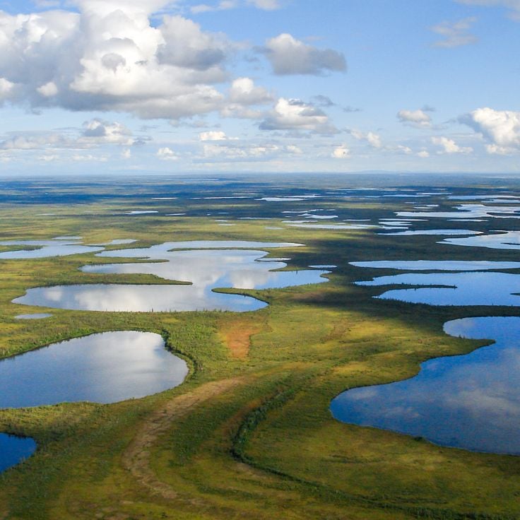
The Yukon Territory in northern Canada holds a collection of natural areas and historical sites located away from main highways. Visitors discover sand dunes, canyons, glacier landscapes, and natural features like Emerald Lake and hot springs. The region shaped its identity through the gold rush era, which is reflected in towns like Dawson City and in museums that tell these stories of discovery and settlement.
The collection includes national parks such as Ivvavik and Kluane that reveal wilderness and mountains, as well as river landscapes with rapids and narrows. Historic sites like Fort Selkirk, the SS Keno river steamer, and the Old Log Church document how indigenous peoples, gold seekers, and early settlers lived in this remote region. Museums in Whitehorse and Dawson City show the history of these communities, from ancient times through the gold rush to modern days.
The landscape also offers unusual natural formations such as the sand dunes near Carcross, the pingos around Tuktoyaktuk, and the mountains of Tombstone Park. Roads like the Klondike Highway and Top of the World Highway connect these scattered places and small villages. Each site reveals something about how people lived and worked in this northern corner of Canada.
Yukon gathers rare geological formations and places full of history. You can reach it by roads that go through mountain landscapes.
The Yukon Territory in northern Canada holds a collection of natural areas and historical sites located away from main highways. Visitors discover sand dunes, canyons, glacier landscapes, and natural features like Emerald Lake and hot springs. The region shaped its identity through the gold rush era, which is reflected in towns like Dawson City and in museums that tell these stories of discovery and settlement.
The collection includes national parks such as Ivvavik and Kluane that reveal wilderness and mountains, as well as river landscapes with rapids and narrows. Historic sites like Fort Selkirk, the SS Keno river steamer, and the Old Log Church document how indigenous peoples, gold seekers, and early settlers lived in this remote region. Museums in Whitehorse and Dawson City show the history of these communities, from ancient times through the gold rush to modern days.
The landscape also offers unusual natural formations such as the sand dunes near Carcross, the pingos around Tuktoyaktuk, and the mountains of Tombstone Park. Roads like the Klondike Highway and Top of the World Highway connect these scattered places and small villages. Each site reveals something about how people lived and worked in this northern corner of Canada.
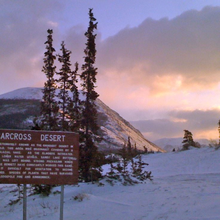
This former glacial sand deposit in Carcross is a natural area within the Yukon's collection of remote sites and historic locations. Formed by glacial sediments during the last ice age, the deposit features sand dunes scattered among pine forests. This unusual landscape offers insight into the geological history of northern Canada.
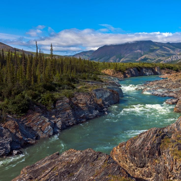
Miles Canyon is a natural gorge in this remote area of the Yukon, where the Yukon River has carved through basalt rock walls. The cliff faces rise about 50 meters above the water and are surrounded by pine forests. The canyon reveals the geological history of northern Canada and offers visitors a place to explore the natural landscapes of the territory.
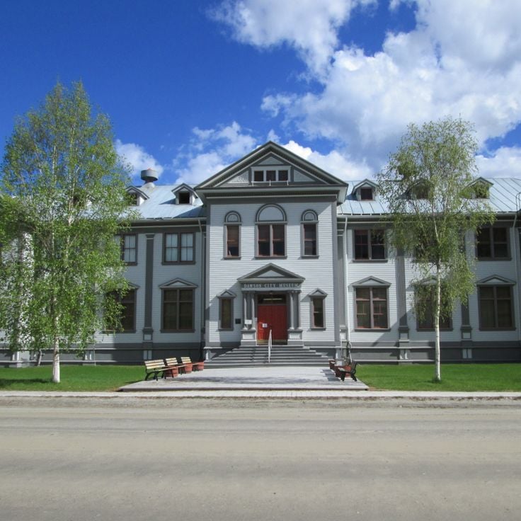
The Dawson City Museum displays mining equipment, photographs and artifacts from the 1898 Klondike Gold Rush. Located in a former territorial administration building, it preserves the story of this pivotal period in northern Canada. This museum connects visitors to the remote historical sites of the Yukon and the prospectors who shaped the region.
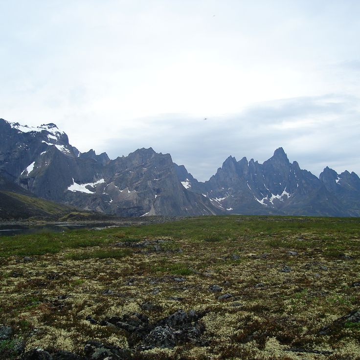
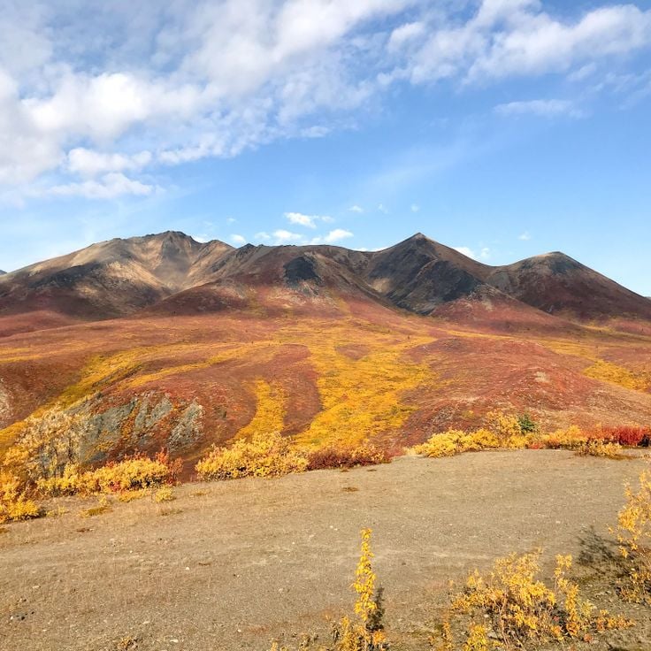
Tombstone Territorial Park is a protected area in the Tombstone Mountains and represents one of the remote natural areas of the Yukon found away from main routes. The park showcases the wild landscapes of northern Canada with mountains, permafrost formations, and valleys. Here grow arctic and subarctic plant species adapted to the harsh climate. The park offers visitors the opportunity to experience the raw natural environment of the north.
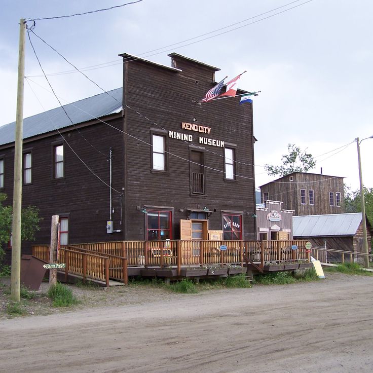
The Keno City Mining Museum tells the story of silver mining in this remote part of the Yukon. The museum holds artifacts, equipment, photographs and documents from the silver mines that operated in this region between 1919 and 1989. It preserves an important chapter of mining history in northern Canada.
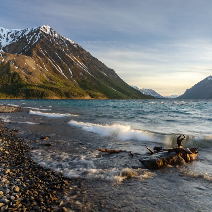
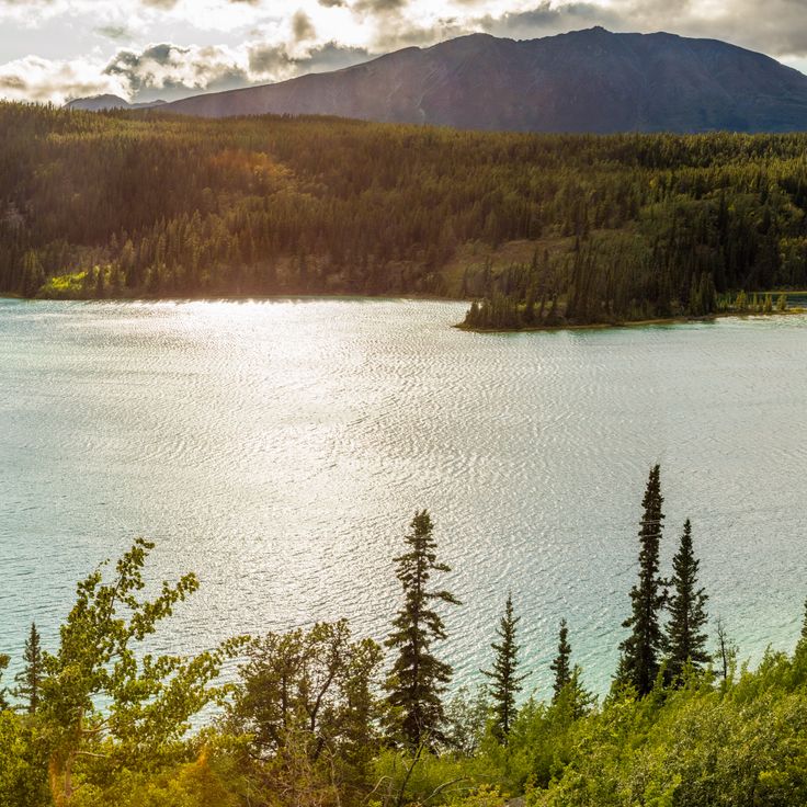
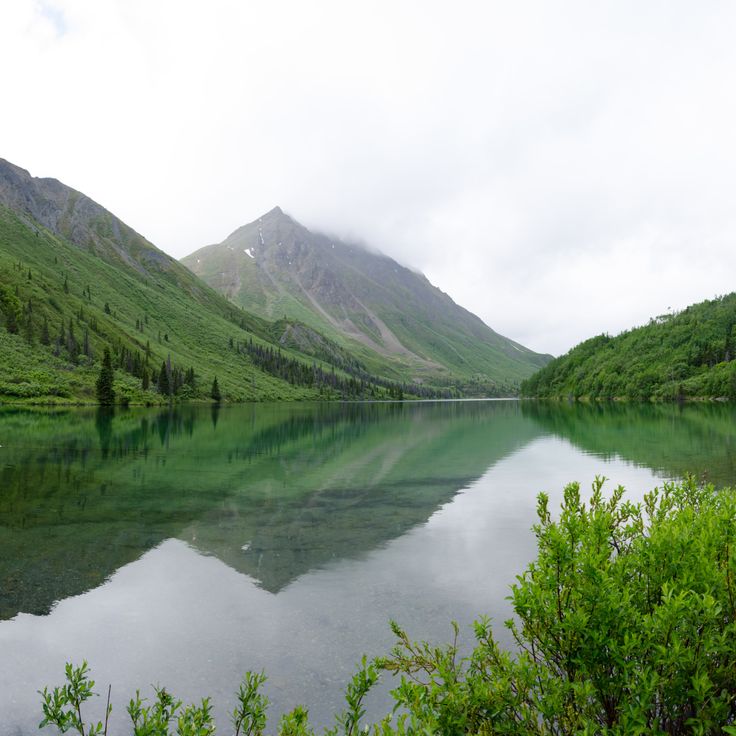
Emerald Lake is located in Southern Lakes and represents one of the remote natural areas found throughout Yukon Territory. The lake's distinctive green color comes from light reflecting off white calcium carbonate deposits on the bottom, which form from limestone erosion. This natural phenomenon makes it a notable feature among Yukon's varied landscapes.
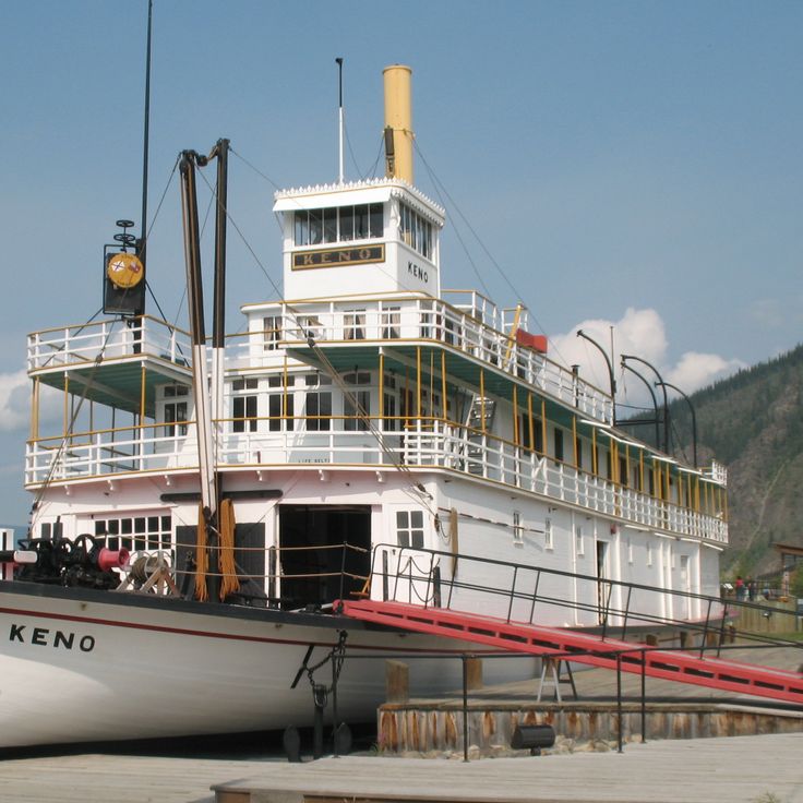
The SS Keno is a preserved steamboat that transported silver, lead and zinc ore on the Stewart and Yukon Rivers between 1922 and 1951. As part of Yukon's remote natural areas and historical sites, this vessel shows how mining and river transport shaped life in northern Canada during the post-gold rush era.
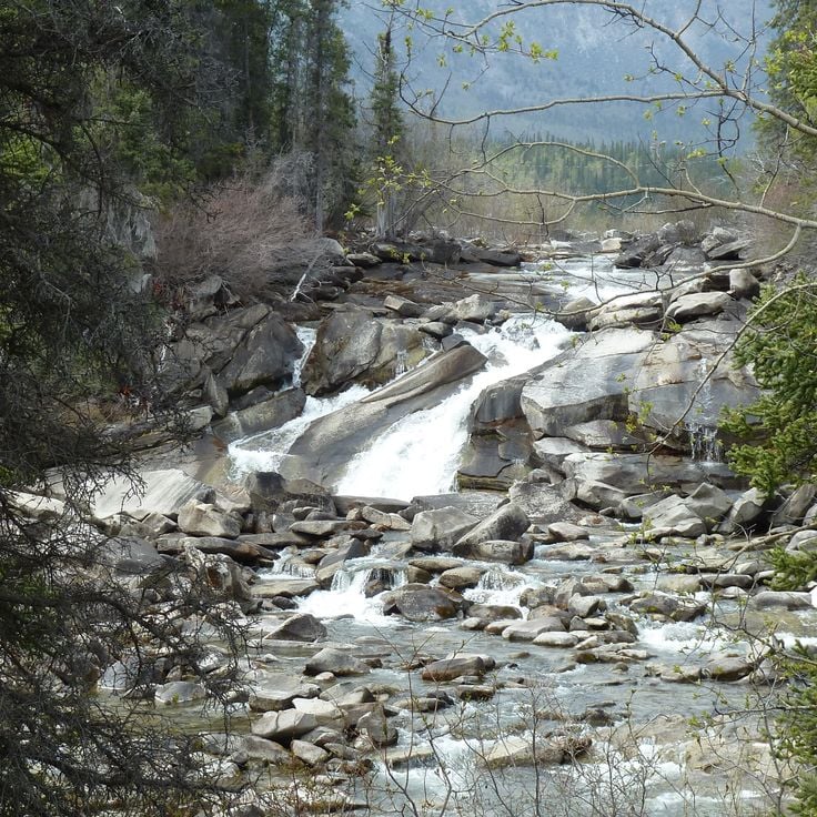
Five Finger Rapids is a natural formation on the Yukon River near Minto. Four rock pillars rise from the riverbed and split the water into five separate channels. The current flows forcefully around these obstacles, creating complex and swirling patterns that made river travel difficult for early explorers and gold rush travelers who navigated these waters.
Ivvavik National Park is Canada's northernmost national park, showcasing the raw tundra landscapes of the Yukon's remote reaches. The park provides habitat for grizzly bears, wolves, and large caribou herds that move across the vast terrain. As part of the Yukon's collection of remote natural areas, this park represents the untamed wilderness that visitors seek when traveling far from main routes in northern Canada.
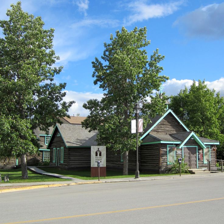
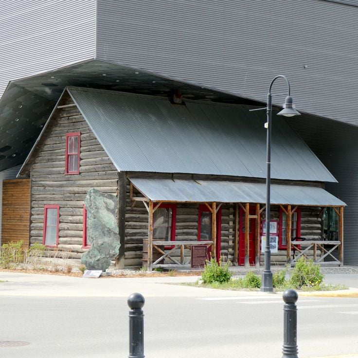
Built in 1900, the Old Log Church Museum displays religious objects and documents from the first Anglican missionaries in Yukon. As part of the collection of natural areas and historical sites in Yukon away from main routes, this museum offers insight into the religious and settlement history of the region.
The Yukon Beringia Interpretive Centre is a museum in Whitehorse that documents the region during the last ice age. It displays fossils, artifacts, and replicas of prehistoric animals that once roamed this northern landscape. This centre helps visitors understand the deep history of Yukon and how the land changed over thousands of years.
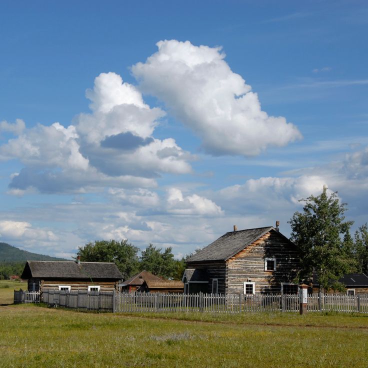
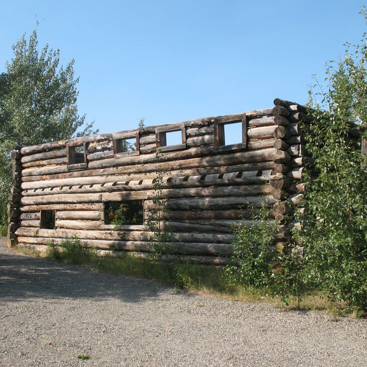
Fort Selkirk Historic Site is a 19th-century trading post along the Yukon River. The site contains restored buildings that tell the story of cooperation between traders and indigenous peoples. As part of Yukon's remote natural areas and historic sites, this location offers insight into fur trade life and the relationships that shaped the region.
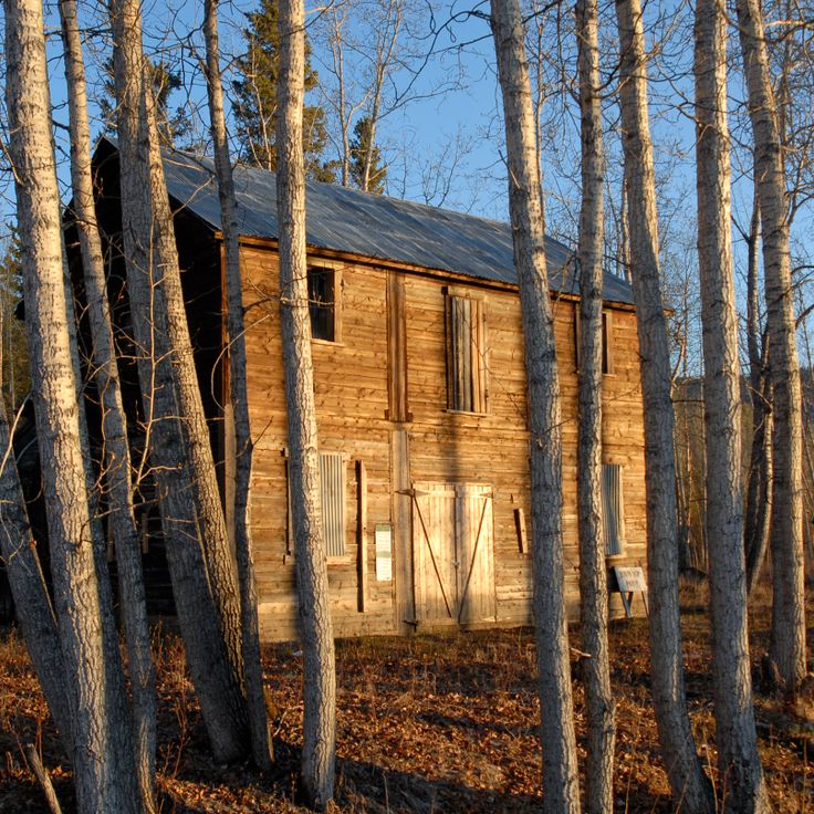
The Montague Roadhouse Site is an early 1900s rest station in Yukon where original structures remain from the gold rush era. Travelers heading between Dawson City and Whitehorse would stop here to rest and resupply. This site shows how the roadhouse network supported journeys through remote northern territory during the rush for gold.
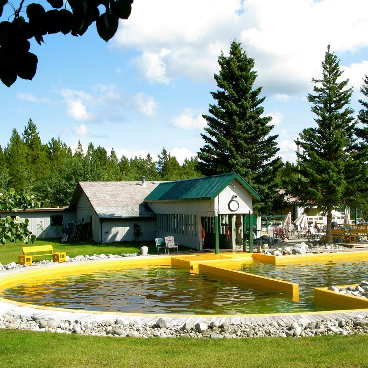
Takhini Mineral Springs are natural warm springs near Whitehorse in the Yukon that maintain a temperature of 36 degrees Celsius year-round. The water contains high concentrations of calcium, magnesium and iron. These springs are part of the remote natural areas and historic sites of the Yukon, located away from main routes and offering visitors access to natural phenomena like glacier landscapes and hot springs throughout the territory.
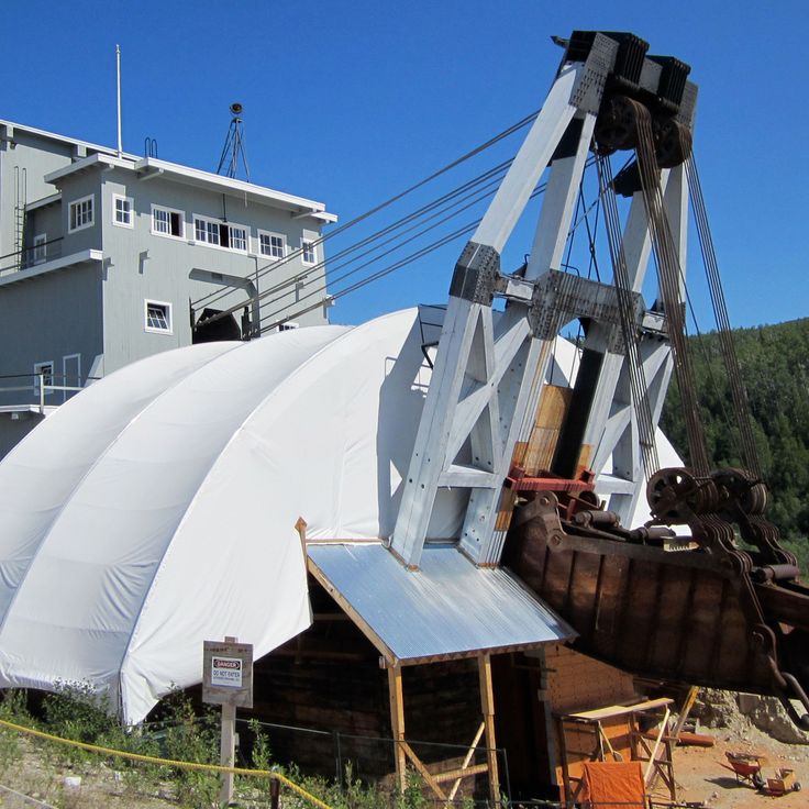
The Dredge No. 4 stands in Dawson City as a testament to the engineering feats that powered gold mining in the Yukon. This massive wooden-hulled vessel was once among the largest of its kind in North America and demonstrates the industrial heritage of the gold rush era. At this site, visitors can see how miners during the gold rush moved enormous quantities of material in search of gold. The location connects the Yukon's natural landscape with its past as a center of gold extraction.
Old Crow Village is a remote Vuntut Gwitchin community situated along the Porcupine River in northern Yukon. As part of this collection of natural areas and historic sites, the village offers a window into life in one of Canada's most northern settlements. Visitors can experience the traditions and stories of the people who have lived on this land for generations.
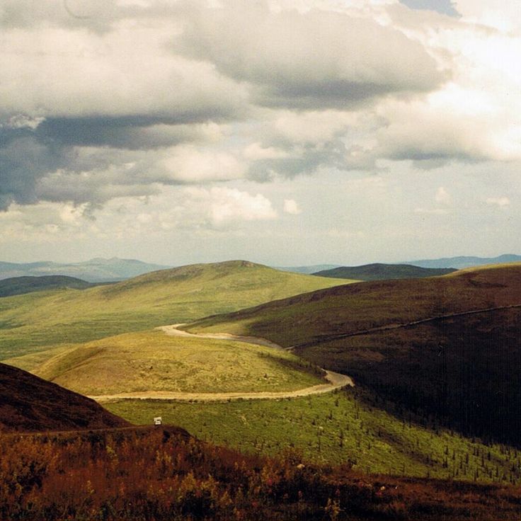
This viewpoint sits along the Dempster Highway and lets you see the peaks and valleys that shape the Yukon landscape. The observation point overlooks the region from all angles, showing the mountainous terrain that characterizes this remote part of northern Canada. It fits naturally among the less-traveled natural areas and historic sites that define the territory.
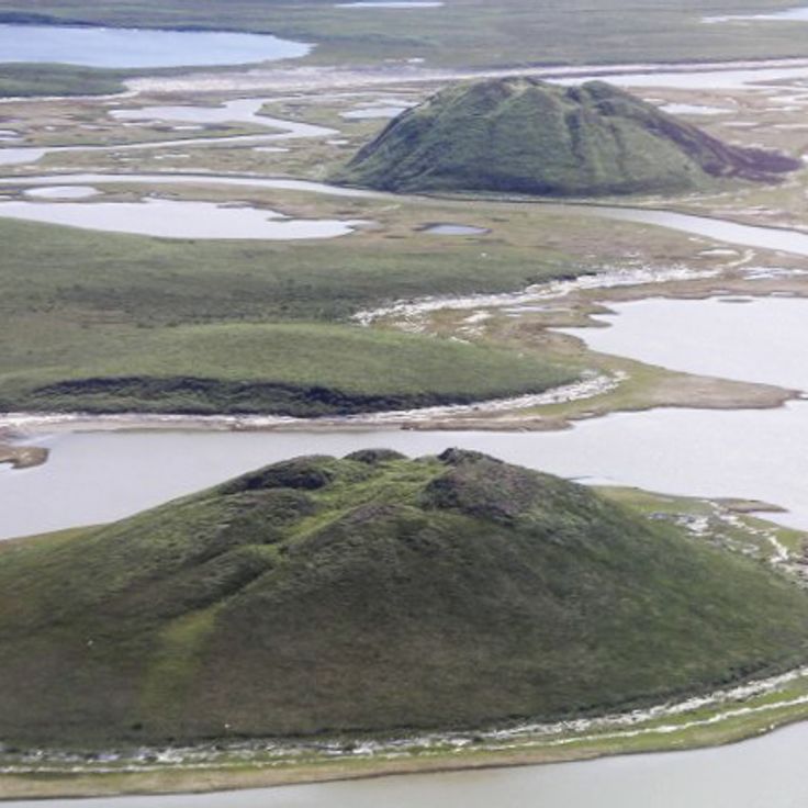
Pingo Canadian Landmark features roughly 1350 frozen earth mounds that rise from the permafrost. These geological formations grow slowly over time as ice expands beneath the ground surface. Located away from main routes in the Yukon, this site shows visitors the natural phenomena found in remote northern Canada, where the land shapes itself through freeze and thaw cycles.
Kluane National Park and Reserve is a vast protected area in the Yukon that encompasses high mountain landscapes. The park is home to Mount Logan, Canada's highest peak, and the Saint Elias Mountains with their snow-covered summits and glaciers. This site represents one of the remote natural areas in the Yukon, offering visitors a chance to experience alpine terrain and pristine wilderness away from main routes.
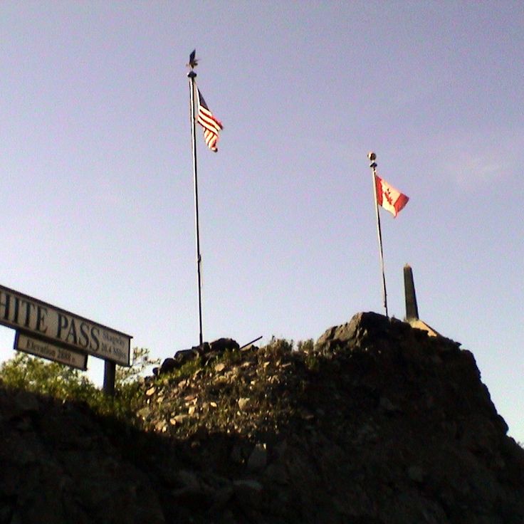
The White Pass & Yukon Route Railway is a historic railroad built in 1898 that carries travelers through remote northern landscapes. This railway connects Whitehorse to distant locations and traces routes once used during the gold rush era. The line winds through mountainous terrain and provides access to historical sites and natural areas far from main roads. Passengers experience the region's frontier history while traveling through valleys and over elevated terrain that shaped the area's development.
The Klondike Highway is a 550-kilometer road connecting Alaska to Yukon, following the historical route that gold miners traveled to reach Dawson City during the gold rush. This road passes through remote areas of northern Canada and allows visitors to experience the same journey as early prospectors did over a century ago.
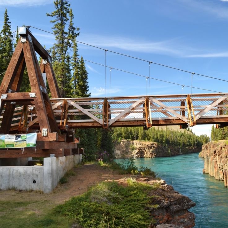
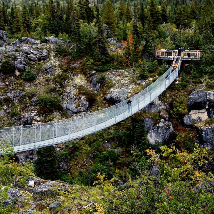
This suspension bridge is part of the remote natural areas and historical sites found throughout the Yukon Territory. The 200-meter structure spans the Tutshi River at a height of 17 meters and features observation platforms above the canyon. It provides visitors with a unique way to experience the northern Canadian landscape.
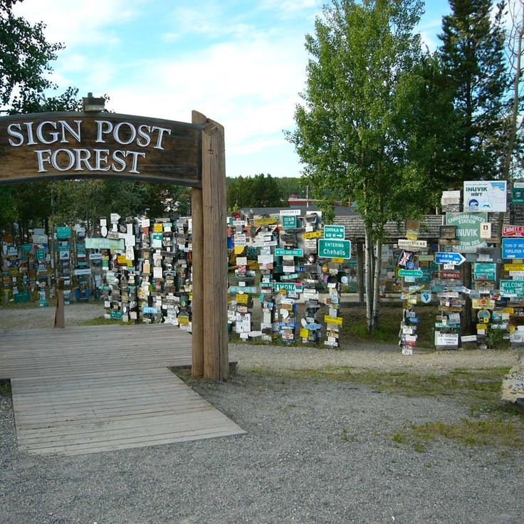
The Sign Post Forest in Watson Lake is a remarkable place where over 80,000 signs from different countries around the world hang among the trees and posts. Founded in 1942 by Carl K. Lindley, this collection has grown as visitors from everywhere bring their own signs to add to the site. The place tells stories of travelers passing through remote Yukon landscapes, with each sign carrying the name of a hometown, a personal message, or a memory from people who journeyed through this northern region.
The MacBride Museum of Yukon History fits into this collection of remote natural areas and historic sites across the Yukon Territory. This museum displays objects that tell the story of the region's gold rush period and how Whitehorse grew into the territory's capital. Through its collections, visitors can trace the path that shaped northern Canada during the late 1800s and beyond.
Vuntut National Park protects arctic tundra landscapes in northern Yukon and serves as a migration corridor for caribou herds. This park represents one of the remote natural areas in the Yukon Territory, situated away from main routes and showcasing the region's diverse natural features alongside its northern landscapes.
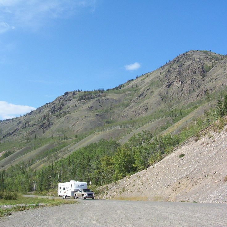
The Top of the World Highway is a mountain road that runs along ridges between Yukon and Alaska, offering views across both regions. This route connects remote areas in northern Canada, where travelers can experience the rugged landscape and natural beauty of the territory. The road winds through unspoiled land, providing a sense of isolation and wonder as it traverses high-altitude terrain.
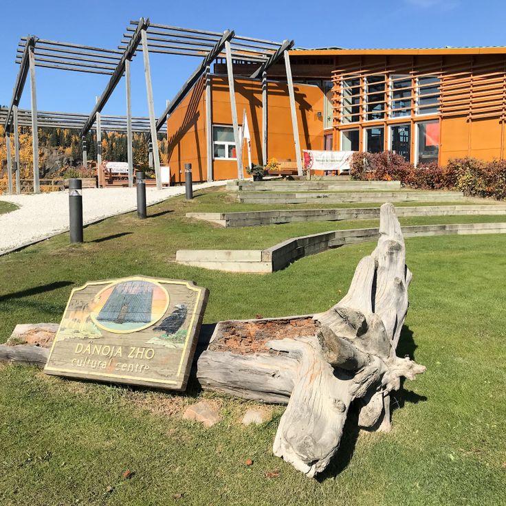
The Dänojà Zho Cultural Centre in Dawson City tells the story of Tr'ondëk Hwëch'in history and traditions through exhibitions and cultural programs. This center sits in the Yukon Territory, a region featuring natural areas and historical sites off the main routes, from sand dunes and canyons to gold rush towns and national parks in northern Canada.
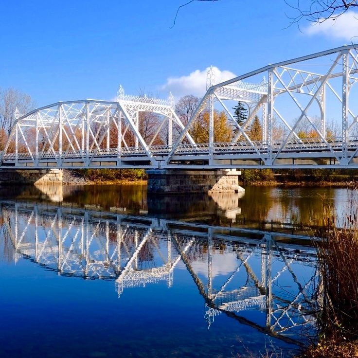
The Minto Bridges are among the few remaining suspension bridges in Yukon, showing the history of infrastructure in this remote region of northern Canada. They span across the Stewart River and offer views of the landscape that is typical of the Yukon's remote natural areas and historical sites.
The Forty Mile Site is a historical location in this remote part of the Yukon that reflects the gold rush era. Located at the confluence of the Yukon and Fortymile Rivers, it reveals how people lived here when gold was discovered. The remains show what a small bustling town was like during that period and offer a window into the daily lives of those who came seeking fortune in northern Canada.
Aishihik Lake is a subarctic mountain lake in the remote Yukon region that exemplifies the wild landscapes found throughout this northern territory. The lake sits surrounded by mountains in a harsh climate and provides habitat for various wildlife species. For local First Nations communities, this place has long served as a traditional hunting ground, reflecting the deep connection between people and the land in northern Canada.
The Yukon Arts Centre in Whitehorse showcases the artistic creativity of the Yukon region. It features performances, exhibitions, and community programs that celebrate local and regional artists. This cultural hub offers a gathering place for people to experience and share art in this remote corner of northern Canada.
Kathleen Lake sits within Kluane National Park and represents one of the remote natural areas found throughout the Yukon Territory. The lake is surrounded by mountains and offers opportunities for hiking and paddling. It showcases the diverse landscape of the region, from glacier formations to mountain scenery.
This former glacial sand deposit in Carcross is a natural area within the Yukon's collection of remote sites and historic locations. Formed by glacial sediments during the last ice age, the deposit features sand dunes scattered among pine forests. This unusual landscape offers insight into the geological history of northern Canada.
Miles Canyon is a natural gorge in this remote area of the Yukon, where the Yukon River has carved through basalt rock walls. The cliff faces rise about 50 meters above the water and are surrounded by pine forests. The canyon reveals the geological history of northern Canada and offers visitors a place to explore the natural landscapes of the territory.
The Dawson City Museum displays mining equipment, photographs and artifacts from the 1898 Klondike Gold Rush. Located in a former territorial administration building, it preserves the story of this pivotal period in northern Canada. This museum connects visitors to the remote historical sites of the Yukon and the prospectors who shaped the region.
Tombstone Territorial Park is a protected area in the Tombstone Mountains and represents one of the remote natural areas of the Yukon found away from main routes. The park showcases the wild landscapes of northern Canada with mountains, permafrost formations, and valleys. Here grow arctic and subarctic plant species adapted to the harsh climate. The park offers visitors the opportunity to experience the raw natural environment of the north.
The Keno City Mining Museum tells the story of silver mining in this remote part of the Yukon. The museum holds artifacts, equipment, photographs and documents from the silver mines that operated in this region between 1919 and 1989. It preserves an important chapter of mining history in northern Canada.
Emerald Lake is located in Southern Lakes and represents one of the remote natural areas found throughout Yukon Territory. The lake's distinctive green color comes from light reflecting off white calcium carbonate deposits on the bottom, which form from limestone erosion. This natural phenomenon makes it a notable feature among Yukon's varied landscapes.
The SS Keno is a preserved steamboat that transported silver, lead and zinc ore on the Stewart and Yukon Rivers between 1922 and 1951. As part of Yukon's remote natural areas and historical sites, this vessel shows how mining and river transport shaped life in northern Canada during the post-gold rush era.
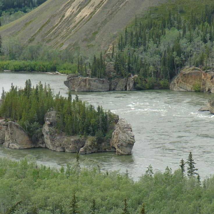
Five Finger Rapids is a natural formation on the Yukon River near Minto. Four rock pillars rise from the riverbed and split the water into five separate channels. The current flows forcefully around these obstacles, creating complex and swirling patterns that made river travel difficult for early explorers and gold rush travelers who navigated these waters.
Ivvavik National Park is Canada's northernmost national park, showcasing the raw tundra landscapes of the Yukon's remote reaches. The park provides habitat for grizzly bears, wolves, and large caribou herds that move across the vast terrain. As part of the Yukon's collection of remote natural areas, this park represents the untamed wilderness that visitors seek when traveling far from main routes in northern Canada.
Built in 1900, the Old Log Church Museum displays religious objects and documents from the first Anglican missionaries in Yukon. As part of the collection of natural areas and historical sites in Yukon away from main routes, this museum offers insight into the religious and settlement history of the region.
The Yukon Beringia Interpretive Centre is a museum in Whitehorse that documents the region during the last ice age. It displays fossils, artifacts, and replicas of prehistoric animals that once roamed this northern landscape. This centre helps visitors understand the deep history of Yukon and how the land changed over thousands of years.
Fort Selkirk Historic Site is a 19th-century trading post along the Yukon River. The site contains restored buildings that tell the story of cooperation between traders and indigenous peoples. As part of Yukon's remote natural areas and historic sites, this location offers insight into fur trade life and the relationships that shaped the region.
The Montague Roadhouse Site is an early 1900s rest station in Yukon where original structures remain from the gold rush era. Travelers heading between Dawson City and Whitehorse would stop here to rest and resupply. This site shows how the roadhouse network supported journeys through remote northern territory during the rush for gold.
Takhini Mineral Springs are natural warm springs near Whitehorse in the Yukon that maintain a temperature of 36 degrees Celsius year-round. The water contains high concentrations of calcium, magnesium and iron. These springs are part of the remote natural areas and historic sites of the Yukon, located away from main routes and offering visitors access to natural phenomena like glacier landscapes and hot springs throughout the territory.
The Dredge No. 4 stands in Dawson City as a testament to the engineering feats that powered gold mining in the Yukon. This massive wooden-hulled vessel was once among the largest of its kind in North America and demonstrates the industrial heritage of the gold rush era. At this site, visitors can see how miners during the gold rush moved enormous quantities of material in search of gold. The location connects the Yukon's natural landscape with its past as a center of gold extraction.
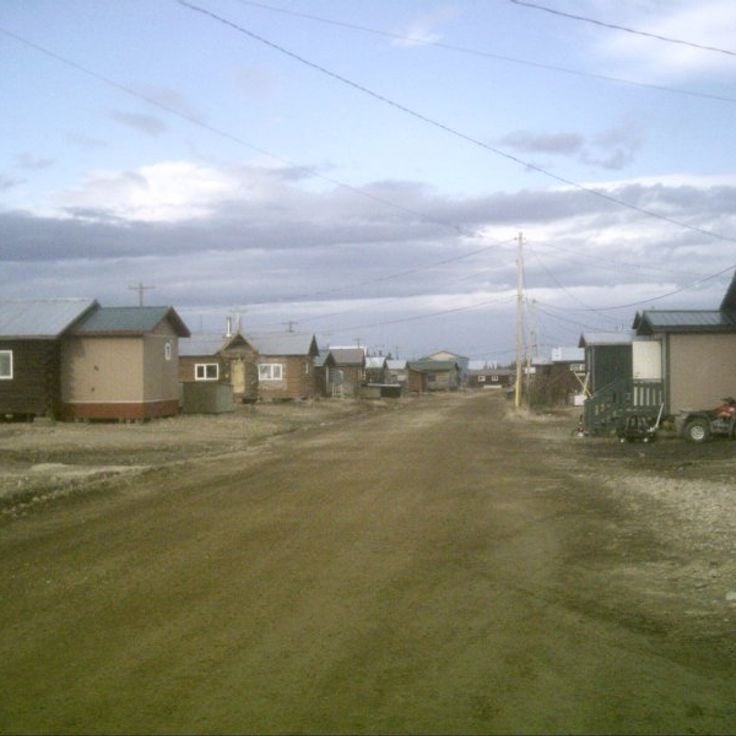
Old Crow Village is a remote Vuntut Gwitchin community situated along the Porcupine River in northern Yukon. As part of this collection of natural areas and historic sites, the village offers a window into life in one of Canada's most northern settlements. Visitors can experience the traditions and stories of the people who have lived on this land for generations.
This viewpoint sits along the Dempster Highway and lets you see the peaks and valleys that shape the Yukon landscape. The observation point overlooks the region from all angles, showing the mountainous terrain that characterizes this remote part of northern Canada. It fits naturally among the less-traveled natural areas and historic sites that define the territory.
Pingo Canadian Landmark features roughly 1350 frozen earth mounds that rise from the permafrost. These geological formations grow slowly over time as ice expands beneath the ground surface. Located away from main routes in the Yukon, this site shows visitors the natural phenomena found in remote northern Canada, where the land shapes itself through freeze and thaw cycles.
Kluane National Park and Reserve is a vast protected area in the Yukon that encompasses high mountain landscapes. The park is home to Mount Logan, Canada's highest peak, and the Saint Elias Mountains with their snow-covered summits and glaciers. This site represents one of the remote natural areas in the Yukon, offering visitors a chance to experience alpine terrain and pristine wilderness away from main routes.
The White Pass & Yukon Route Railway is a historic railroad built in 1898 that carries travelers through remote northern landscapes. This railway connects Whitehorse to distant locations and traces routes once used during the gold rush era. The line winds through mountainous terrain and provides access to historical sites and natural areas far from main roads. Passengers experience the region's frontier history while traveling through valleys and over elevated terrain that shaped the area's development.
The Klondike Highway is a 550-kilometer road connecting Alaska to Yukon, following the historical route that gold miners traveled to reach Dawson City during the gold rush. This road passes through remote areas of northern Canada and allows visitors to experience the same journey as early prospectors did over a century ago.
This suspension bridge is part of the remote natural areas and historical sites found throughout the Yukon Territory. The 200-meter structure spans the Tutshi River at a height of 17 meters and features observation platforms above the canyon. It provides visitors with a unique way to experience the northern Canadian landscape.
The Sign Post Forest in Watson Lake is a remarkable place where over 80,000 signs from different countries around the world hang among the trees and posts. Founded in 1942 by Carl K. Lindley, this collection has grown as visitors from everywhere bring their own signs to add to the site. The place tells stories of travelers passing through remote Yukon landscapes, with each sign carrying the name of a hometown, a personal message, or a memory from people who journeyed through this northern region.
The MacBride Museum of Yukon History fits into this collection of remote natural areas and historic sites across the Yukon Territory. This museum displays objects that tell the story of the region's gold rush period and how Whitehorse grew into the territory's capital. Through its collections, visitors can trace the path that shaped northern Canada during the late 1800s and beyond.
Vuntut National Park protects arctic tundra landscapes in northern Yukon and serves as a migration corridor for caribou herds. This park represents one of the remote natural areas in the Yukon Territory, situated away from main routes and showcasing the region's diverse natural features alongside its northern landscapes.
The Top of the World Highway is a mountain road that runs along ridges between Yukon and Alaska, offering views across both regions. This route connects remote areas in northern Canada, where travelers can experience the rugged landscape and natural beauty of the territory. The road winds through unspoiled land, providing a sense of isolation and wonder as it traverses high-altitude terrain.
The Dänojà Zho Cultural Centre in Dawson City tells the story of Tr'ondëk Hwëch'in history and traditions through exhibitions and cultural programs. This center sits in the Yukon Territory, a region featuring natural areas and historical sites off the main routes, from sand dunes and canyons to gold rush towns and national parks in northern Canada.
The Minto Bridges are among the few remaining suspension bridges in Yukon, showing the history of infrastructure in this remote region of northern Canada. They span across the Stewart River and offer views of the landscape that is typical of the Yukon's remote natural areas and historical sites.
The Forty Mile Site is a historical location in this remote part of the Yukon that reflects the gold rush era. Located at the confluence of the Yukon and Fortymile Rivers, it reveals how people lived here when gold was discovered. The remains show what a small bustling town was like during that period and offer a window into the daily lives of those who came seeking fortune in northern Canada.
Aishihik Lake is a subarctic mountain lake in the remote Yukon region that exemplifies the wild landscapes found throughout this northern territory. The lake sits surrounded by mountains in a harsh climate and provides habitat for various wildlife species. For local First Nations communities, this place has long served as a traditional hunting ground, reflecting the deep connection between people and the land in northern Canada.
The Yukon Arts Centre in Whitehorse showcases the artistic creativity of the Yukon region. It features performances, exhibitions, and community programs that celebrate local and regional artists. This cultural hub offers a gathering place for people to experience and share art in this remote corner of northern Canada.
Kathleen Lake sits within Kluane National Park and represents one of the remote natural areas found throughout the Yukon Territory. The lake is surrounded by mountains and offers opportunities for hiking and paddling. It showcases the diverse landscape of the region, from glacier formations to mountain scenery.
This former glacial sand deposit in Carcross is a natural area within the Yukon's collection of remote sites and historic locations. Formed by glacial sediments during the last ice age, the deposit features sand dunes scattered among pine forests. This unusual landscape offers insight into the geological history of northern Canada.
Miles Canyon is a natural gorge in this remote area of the Yukon, where the Yukon River has carved through basalt rock walls. The cliff faces rise about 50 meters above the water and are surrounded by pine forests. The canyon reveals the geological history of northern Canada and offers visitors a place to explore the natural landscapes of the territory.
The Dawson City Museum displays mining equipment, photographs and artifacts from the 1898 Klondike Gold Rush. Located in a former territorial administration building, it preserves the story of this pivotal period in northern Canada. This museum connects visitors to the remote historical sites of the Yukon and the prospectors who shaped the region.
Tombstone Territorial Park is a protected area in the Tombstone Mountains and represents one of the remote natural areas of the Yukon found away from main routes. The park showcases the wild landscapes of northern Canada with mountains, permafrost formations, and valleys. Here grow arctic and subarctic plant species adapted to the harsh climate. The park offers visitors the opportunity to experience the raw natural environment of the north.
The Keno City Mining Museum tells the story of silver mining in this remote part of the Yukon. The museum holds artifacts, equipment, photographs and documents from the silver mines that operated in this region between 1919 and 1989. It preserves an important chapter of mining history in northern Canada.
Emerald Lake is located in Southern Lakes and represents one of the remote natural areas found throughout Yukon Territory. The lake's distinctive green color comes from light reflecting off white calcium carbonate deposits on the bottom, which form from limestone erosion. This natural phenomenon makes it a notable feature among Yukon's varied landscapes.
The SS Keno is a preserved steamboat that transported silver, lead and zinc ore on the Stewart and Yukon Rivers between 1922 and 1951. As part of Yukon's remote natural areas and historical sites, this vessel shows how mining and river transport shaped life in northern Canada during the post-gold rush era.
Five Finger Rapids is a natural formation on the Yukon River near Minto. Four rock pillars rise from the riverbed and split the water into five separate channels. The current flows forcefully around these obstacles, creating complex and swirling patterns that made river travel difficult for early explorers and gold rush travelers who navigated these waters.
Ivvavik National Park is Canada's northernmost national park, showcasing the raw tundra landscapes of the Yukon's remote reaches. The park provides habitat for grizzly bears, wolves, and large caribou herds that move across the vast terrain. As part of the Yukon's collection of remote natural areas, this park represents the untamed wilderness that visitors seek when traveling far from main routes in northern Canada.
Built in 1900, the Old Log Church Museum displays religious objects and documents from the first Anglican missionaries in Yukon. As part of the collection of natural areas and historical sites in Yukon away from main routes, this museum offers insight into the religious and settlement history of the region.
The Yukon Beringia Interpretive Centre is a museum in Whitehorse that documents the region during the last ice age. It displays fossils, artifacts, and replicas of prehistoric animals that once roamed this northern landscape. This centre helps visitors understand the deep history of Yukon and how the land changed over thousands of years.
Fort Selkirk Historic Site is a 19th-century trading post along the Yukon River. The site contains restored buildings that tell the story of cooperation between traders and indigenous peoples. As part of Yukon's remote natural areas and historic sites, this location offers insight into fur trade life and the relationships that shaped the region.
The Montague Roadhouse Site is an early 1900s rest station in Yukon where original structures remain from the gold rush era. Travelers heading between Dawson City and Whitehorse would stop here to rest and resupply. This site shows how the roadhouse network supported journeys through remote northern territory during the rush for gold.
Takhini Mineral Springs are natural warm springs near Whitehorse in the Yukon that maintain a temperature of 36 degrees Celsius year-round. The water contains high concentrations of calcium, magnesium and iron. These springs are part of the remote natural areas and historic sites of the Yukon, located away from main routes and offering visitors access to natural phenomena like glacier landscapes and hot springs throughout the territory.
The Dredge No. 4 stands in Dawson City as a testament to the engineering feats that powered gold mining in the Yukon. This massive wooden-hulled vessel was once among the largest of its kind in North America and demonstrates the industrial heritage of the gold rush era. At this site, visitors can see how miners during the gold rush moved enormous quantities of material in search of gold. The location connects the Yukon's natural landscape with its past as a center of gold extraction.
Old Crow Village is a remote Vuntut Gwitchin community situated along the Porcupine River in northern Yukon. As part of this collection of natural areas and historic sites, the village offers a window into life in one of Canada's most northern settlements. Visitors can experience the traditions and stories of the people who have lived on this land for generations.
This viewpoint sits along the Dempster Highway and lets you see the peaks and valleys that shape the Yukon landscape. The observation point overlooks the region from all angles, showing the mountainous terrain that characterizes this remote part of northern Canada. It fits naturally among the less-traveled natural areas and historic sites that define the territory.
Pingo Canadian Landmark features roughly 1350 frozen earth mounds that rise from the permafrost. These geological formations grow slowly over time as ice expands beneath the ground surface. Located away from main routes in the Yukon, this site shows visitors the natural phenomena found in remote northern Canada, where the land shapes itself through freeze and thaw cycles.
Kluane National Park and Reserve is a vast protected area in the Yukon that encompasses high mountain landscapes. The park is home to Mount Logan, Canada's highest peak, and the Saint Elias Mountains with their snow-covered summits and glaciers. This site represents one of the remote natural areas in the Yukon, offering visitors a chance to experience alpine terrain and pristine wilderness away from main routes.
The White Pass & Yukon Route Railway is a historic railroad built in 1898 that carries travelers through remote northern landscapes. This railway connects Whitehorse to distant locations and traces routes once used during the gold rush era. The line winds through mountainous terrain and provides access to historical sites and natural areas far from main roads. Passengers experience the region's frontier history while traveling through valleys and over elevated terrain that shaped the area's development.
The Klondike Highway is a 550-kilometer road connecting Alaska to Yukon, following the historical route that gold miners traveled to reach Dawson City during the gold rush. This road passes through remote areas of northern Canada and allows visitors to experience the same journey as early prospectors did over a century ago.
This suspension bridge is part of the remote natural areas and historical sites found throughout the Yukon Territory. The 200-meter structure spans the Tutshi River at a height of 17 meters and features observation platforms above the canyon. It provides visitors with a unique way to experience the northern Canadian landscape.
The Sign Post Forest in Watson Lake is a remarkable place where over 80,000 signs from different countries around the world hang among the trees and posts. Founded in 1942 by Carl K. Lindley, this collection has grown as visitors from everywhere bring their own signs to add to the site. The place tells stories of travelers passing through remote Yukon landscapes, with each sign carrying the name of a hometown, a personal message, or a memory from people who journeyed through this northern region.
The MacBride Museum of Yukon History fits into this collection of remote natural areas and historic sites across the Yukon Territory. This museum displays objects that tell the story of the region's gold rush period and how Whitehorse grew into the territory's capital. Through its collections, visitors can trace the path that shaped northern Canada during the late 1800s and beyond.
Vuntut National Park protects arctic tundra landscapes in northern Yukon and serves as a migration corridor for caribou herds. This park represents one of the remote natural areas in the Yukon Territory, situated away from main routes and showcasing the region's diverse natural features alongside its northern landscapes.
The Top of the World Highway is a mountain road that runs along ridges between Yukon and Alaska, offering views across both regions. This route connects remote areas in northern Canada, where travelers can experience the rugged landscape and natural beauty of the territory. The road winds through unspoiled land, providing a sense of isolation and wonder as it traverses high-altitude terrain.
The Dänojà Zho Cultural Centre in Dawson City tells the story of Tr'ondëk Hwëch'in history and traditions through exhibitions and cultural programs. This center sits in the Yukon Territory, a region featuring natural areas and historical sites off the main routes, from sand dunes and canyons to gold rush towns and national parks in northern Canada.
The Minto Bridges are among the few remaining suspension bridges in Yukon, showing the history of infrastructure in this remote region of northern Canada. They span across the Stewart River and offer views of the landscape that is typical of the Yukon's remote natural areas and historical sites.
The Forty Mile Site is a historical location in this remote part of the Yukon that reflects the gold rush era. Located at the confluence of the Yukon and Fortymile Rivers, it reveals how people lived here when gold was discovered. The remains show what a small bustling town was like during that period and offer a window into the daily lives of those who came seeking fortune in northern Canada.
Aishihik Lake is a subarctic mountain lake in the remote Yukon region that exemplifies the wild landscapes found throughout this northern territory. The lake sits surrounded by mountains in a harsh climate and provides habitat for various wildlife species. For local First Nations communities, this place has long served as a traditional hunting ground, reflecting the deep connection between people and the land in northern Canada.
The Yukon Arts Centre in Whitehorse showcases the artistic creativity of the Yukon region. It features performances, exhibitions, and community programs that celebrate local and regional artists. This cultural hub offers a gathering place for people to experience and share art in this remote corner of northern Canada.
Kathleen Lake sits within Kluane National Park and represents one of the remote natural areas found throughout the Yukon Territory. The lake is surrounded by mountains and offers opportunities for hiking and paddling. It showcases the diverse landscape of the region, from glacier formations to mountain scenery.
Yukon awaits you for a meeting with natural surroundings. Before you leave, check the road conditions because the seasons change quickly and some paths become inaccessible in winter. This region will teach you that real wealth was not gold, but the ability to survive and adapt in a tough environment.