See the monuments around you in AROpen chests in the app
Around Us is built for your phone — point your camera at the streets and discover the monuments and places around you in augmented reality.Around Us is built for your phone — chests unlock when you walk, explore and capture nearby places.
Switzerland offers much more than its famous destinations. This collection features places where nature and history are discovered at a gentle pace, far from crowds. You will find mountain refuges perched on rocks like Berggasthaus Aescher-Wildkirchli, wild valleys where ibex and chamois live, like Creux du Van, or medieval monasteries preserved in mountain villages such as Santa Maria.
Each place tells a different story. Mount San Giorgio reveals fossils that are 240 million years old. Lauterbrunnen Valley has 72 waterfalls cascading down limestone cliffs. Binntal offers the chance to explore old mining tunnels in the heart of the Alps. These spots invite you to take your time, walk, observe, and feel the diversity of landscapes and traditions that make up Switzerland.
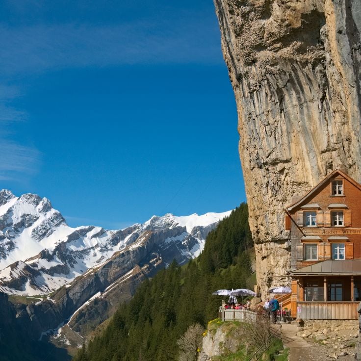
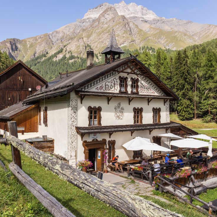
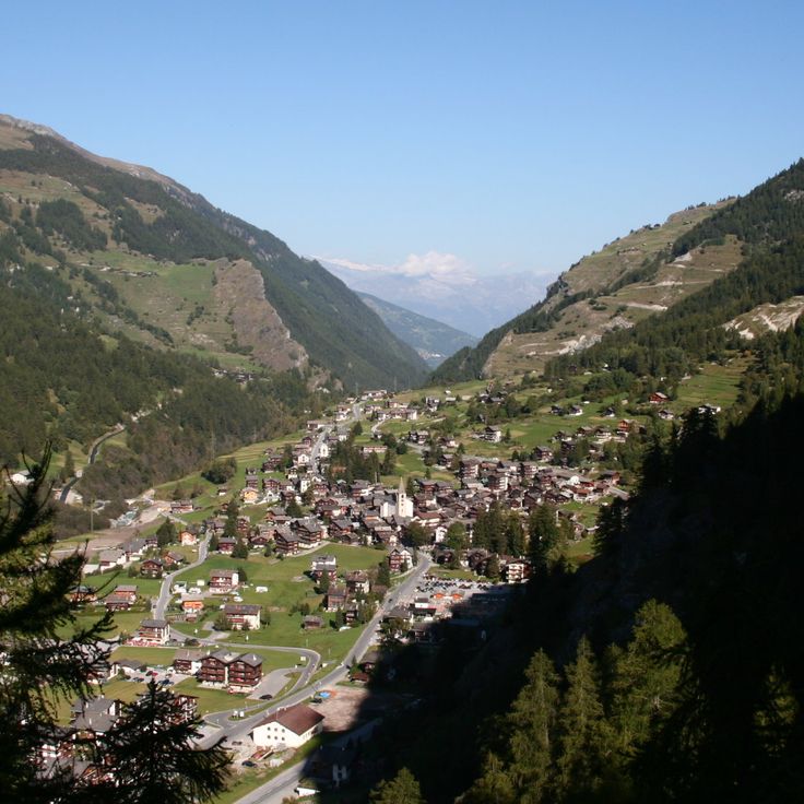
The Berggasthaus Aescher-Wildkirchli is a mountain guesthouse built directly into a rock face at 4770 feet (1454 meters) above sea level. The house is more than 170 years old and provides shelter for hikers and visitors in the Appenzell Alps. From here you can see the valleys and mountains of the region, and the building itself looks like part of the cliff. The location is remote, and you can only reach the guesthouse on foot. There is a terrace where you can enjoy the view, and inside everything is simple, as is typical for a mountain guesthouse.
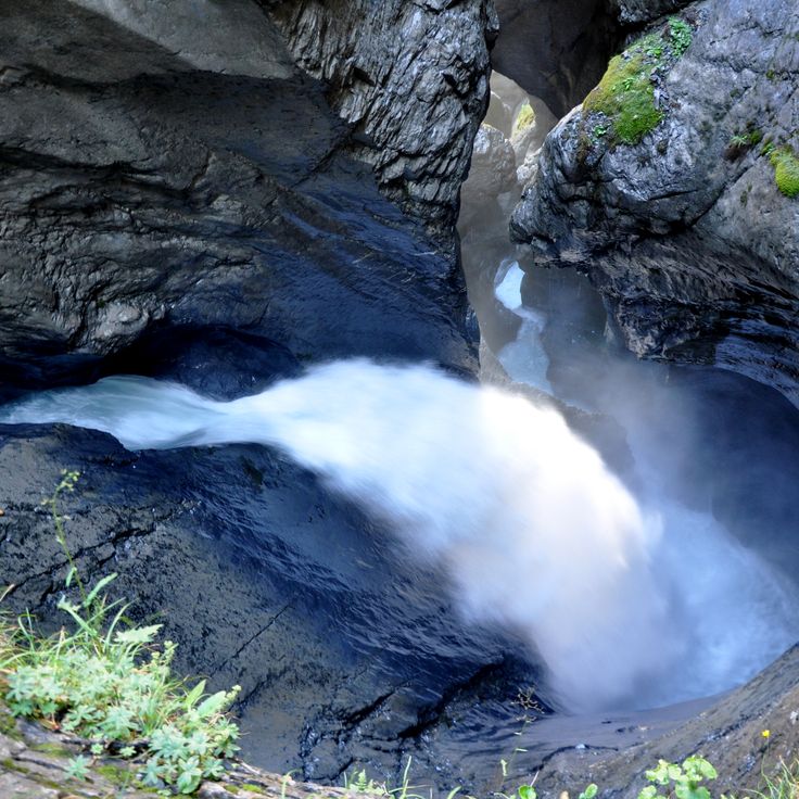
The waterfalls in the Lauterbrunnen Valley are among the landmarks of the Swiss Alps. A total of 72 cascades drop from limestone walls that rise 300 meters (984 feet) into the air. The most famous are Staubbach Falls and Trümmelbach Falls, which flow inside the mountain through rock gorges. The valley is bordered by steep walls, between which meadows and small villages stretch out. You can hear the sound of water from almost anywhere. The falls are accessible on foot or by train, and several hiking trails run through the landscape. In summer, the meltwater flows particularly strong, while in winter icicles form on the rocks. This place shows the power of nature in one of the deepest valleys in the Alps.
Monte San Giorgio holds one of the most complete fossil collections from the Middle Triassic period ever discovered. On the slopes of this mountain in Ticino, fossilized remains of marine life that existed 240 million years ago in a subtropical sea are preserved in layers of rock. The site contains remains of marine reptiles, fish, and invertebrates whose exceptional preservation allows for scientific research at the highest level. Access to these geological layers is now possible through educational trails that explain the formations and offer a view into a vanished world. The fossil sites lie among forests and alpine meadows that attract hikers and fossil enthusiasts during the summer months.
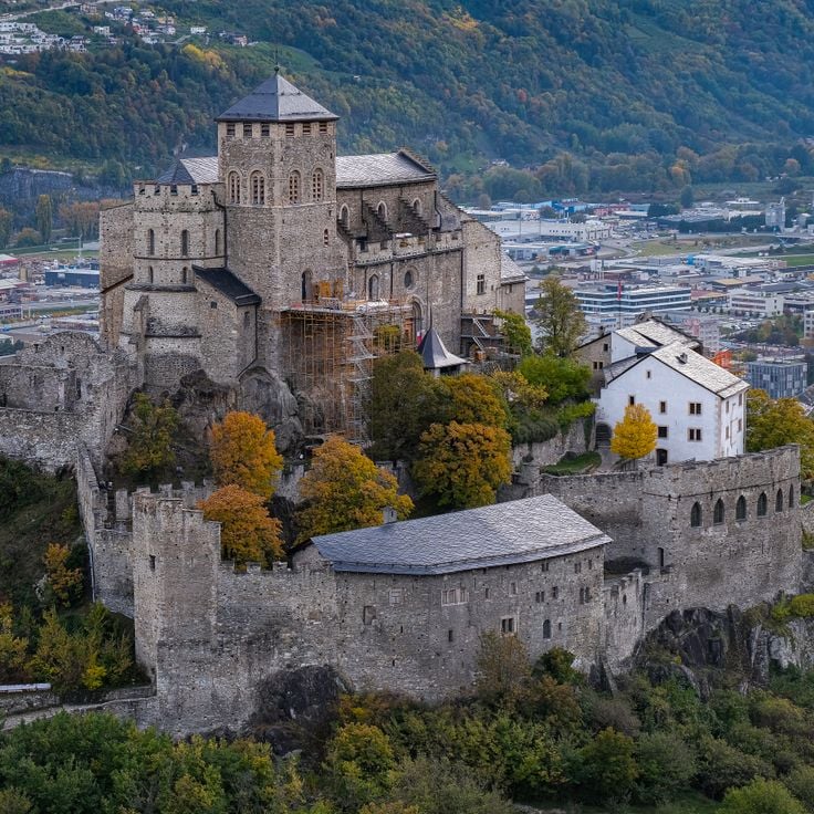
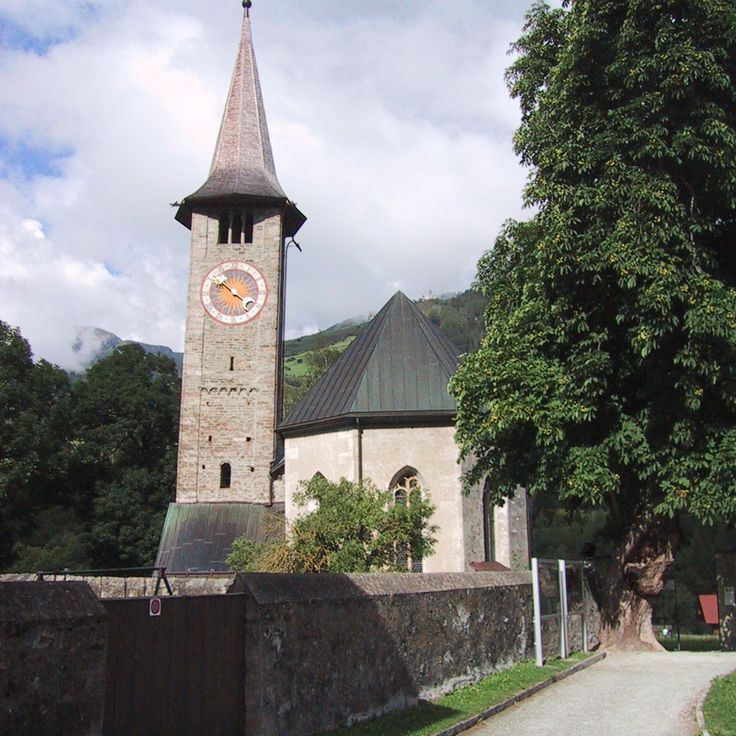
The Basilica of Valère is a Romanesque church from the 11th century standing on a hill above the town of Sion. It was built as a fortified church, surrounded by defensive walls that remain visible today. Inside, one of the oldest playable organs in the world dates from the 15th century and is used for concerts. The church displays frescoes on the walls and a wooden ceiling preserved over the centuries. From the terrace, the Rhone Valley and surrounding mountains come into view. The climb to the basilica follows a paved path winding through the old town.
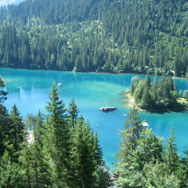
Caumasee sits in a hollow at 3,300 feet (1,000 meters) elevation, surrounded by fir forest. The water is mineralized and the lake reaches a depth of 50 feet (15 meters). In summer the water warms thanks to the sheltered position, and families come to swim and picnic. A path runs through the forest around the shore, and several wooden piers extend into the water. The atmosphere is quiet, with light filtering through the trees onto the surface, which shimmers turquoise. In winter the lake sometimes freezes over completely.
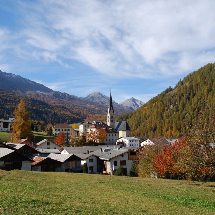
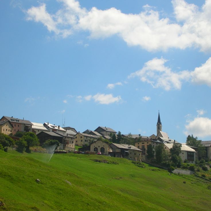
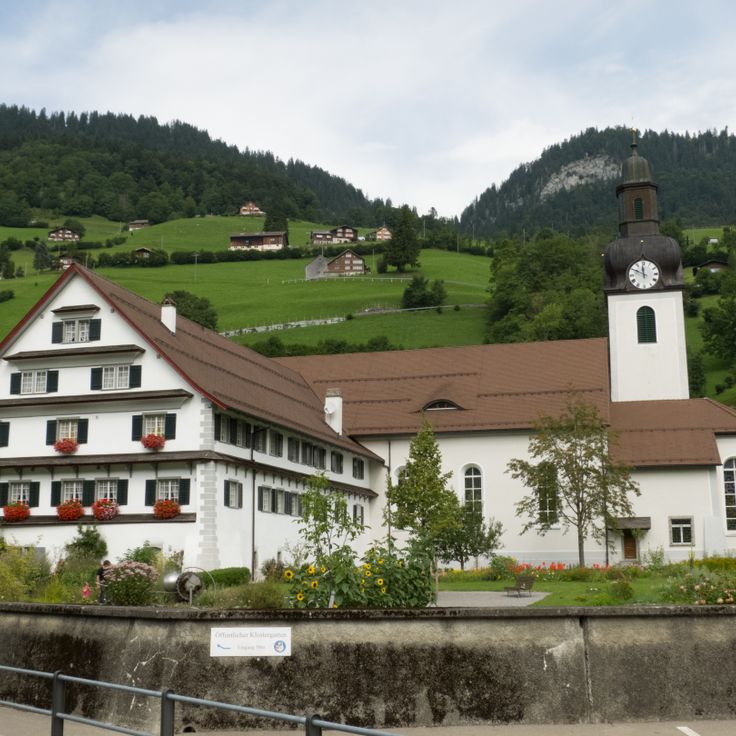
The village sits at 4510 feet (1375 meters) in the Müstair valley, near the Italian border, where Romansh is still spoken today. Santa Maria preserves a Romanesque monastery from the 8th century, its church decorated with medieval wall paintings. The frescoes have been reworked over centuries and depict biblical scenes in bright colors. The monastery was founded by Charlemagne and attracted pilgrims traveling over the Ofen Pass. The surroundings consist of meadows, forests, and mountain slopes that carry snow in winter and are crossed by hiking trails in summer.
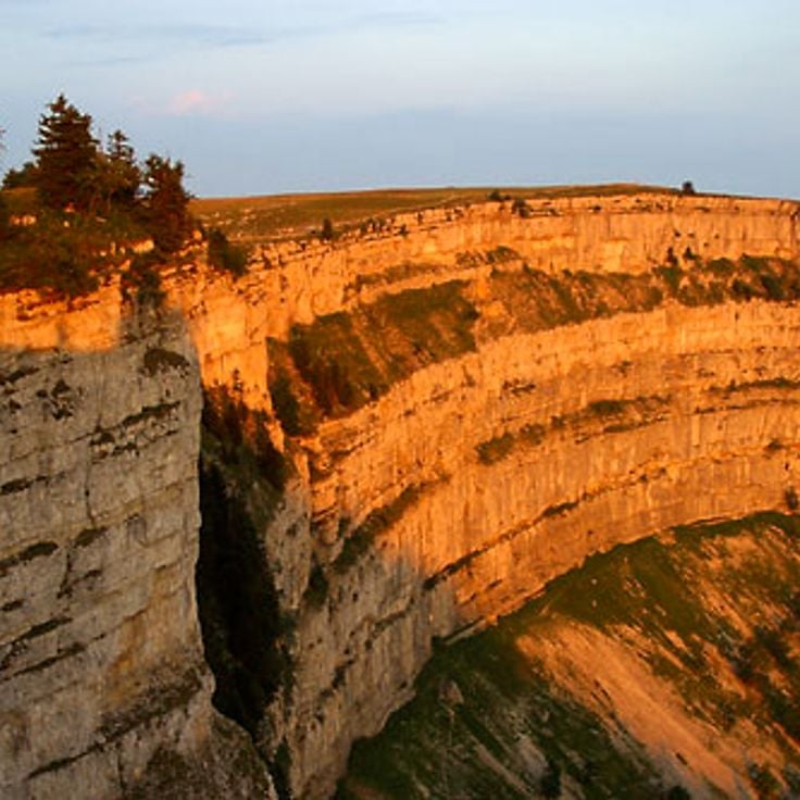
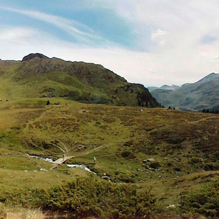
This rock basin in the Neuchâtel Jura has walls that rise up to 525 feet (160 meters) and stretches over a kilometer wide. Ibex and chamois move freely here in a protected area that belongs to the region's nature reserves. Hiking trails lead to the upper rim of the walls, where you can look down into the depth and often observe wildlife climbing steep slopes or resting on the rocks.
Binntal is a high mountain valley in Valais Canton, known for its mineral deposits. Over 300 different mineral species occur in this region. Along the hiking trails, old tunnels and mine shafts recall the area's mining past. The landscape consists of steep rock walls, scree slopes, and mountain streams. Marked paths allow visitors to explore the geological history of the Alps and follow traces of human mining activity from past centuries.
This mountain farm sits at 5610 feet (1711 meters) in the Engadine region. It combines overnight accommodation with traditional alpine farming, showing how mountain agriculture still works in the Alps. Guests can stay in simple rooms while the farmers tend their animals, harvest hay, and make cheese. The location provides access to walking paths in the area, where grazing fields reach up to the rock faces.
Vallon de Réchy is an alpine valley in Valais that has remained without trails, huts, or tourism facilities. A meandering stream runs through the valley floor, surrounded by meadows and pastures where rare plant species grow. The area is reached on foot from surrounding villages and is protected as a nature reserve. Vegetation follows the seasons without human interference, and the water maintains its natural course. Hikers find here a valley that has changed little over time, offering quiet for extended observation.
Iseltwald sits on the southern shore of Lake Brienz. The village developed through fishing and timber trade. Old wooden houses and narrow lanes still shape its appearance. A medieval castle stands by the water. You can walk along the lake, explore quiet coves and see forested slopes dropping straight into the turquoise water. In summer, boats dock at the small harbor. The atmosphere is calm, with few visitors. Iseltwald feels like a village that has kept its rhythm, away from the busier places around Interlaken. The light on the water shifts throughout the day, and the sound of the lake is often the only thing you hear.
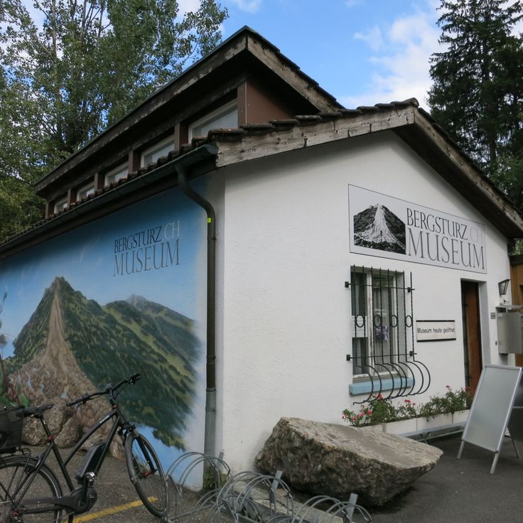
Art Goldau combines a zoo with a sculpture trail on land shaped by a landslide in 1806. Contemporary artworks stand among trees, rocks, and paths where visitors encounter deer, wolves, and wild boar. The connection between nature, animals, and art defines this place, which covers several acres and invites walking. Some sculptures are made of wood, others of metal or stone. You follow a trail that winds through forest and open areas, past enclosures and installations. The site preserves traces of the natural disaster and shows how landscape and life have evolved since then.
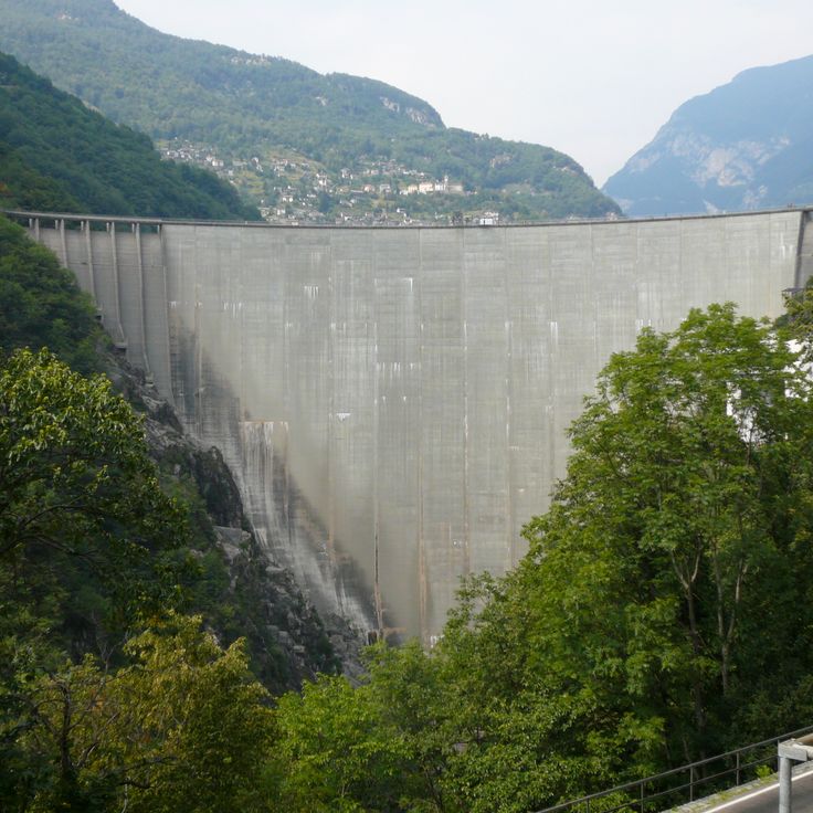
This concrete wall was built in the 1960s to generate electricity for the Ticino region. From the top, you fall 220 meters (722 feet) into the void: the structure serves as a base for bungee jumping, an activity that grew after the GoldenEye film. The dam sits between steep slopes, and the turquoise lake behind it attracts visitors walking through the valley. From the crest, you see the entire Verzasca Valley, its water pooling far below. The contrast between the gray wall and the clear water is impressive, especially when you approach the dam from below.
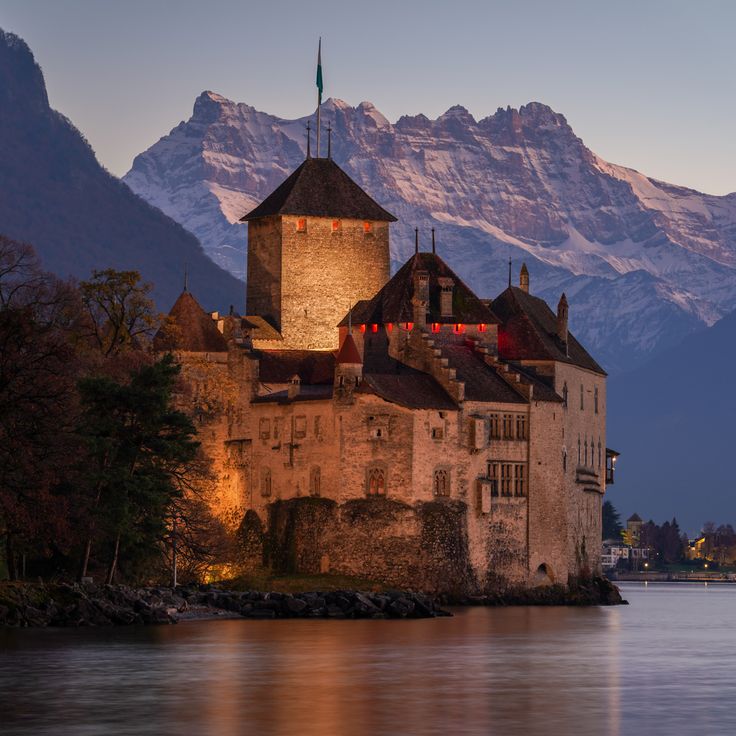
Château de Chillon stands on a rocky island in Lake Geneva, linked to the shore by a wooden bridge. The first mention of the castle dates to the 12th century. From a distance, you can see the defense towers, thick stone walls, and roofs covered with dark slate. Inside, you pass through courtyards, vaulted cellars, and halls with carved wooden ceilings. Lord Byron visited in the 19th century and left his signature on a pillar in the dungeon. From the lakeshore, the Vaud Alps rise in the background. The castle has kept its medieval layout and fortifications. It shows how a border stronghold worked on the water.
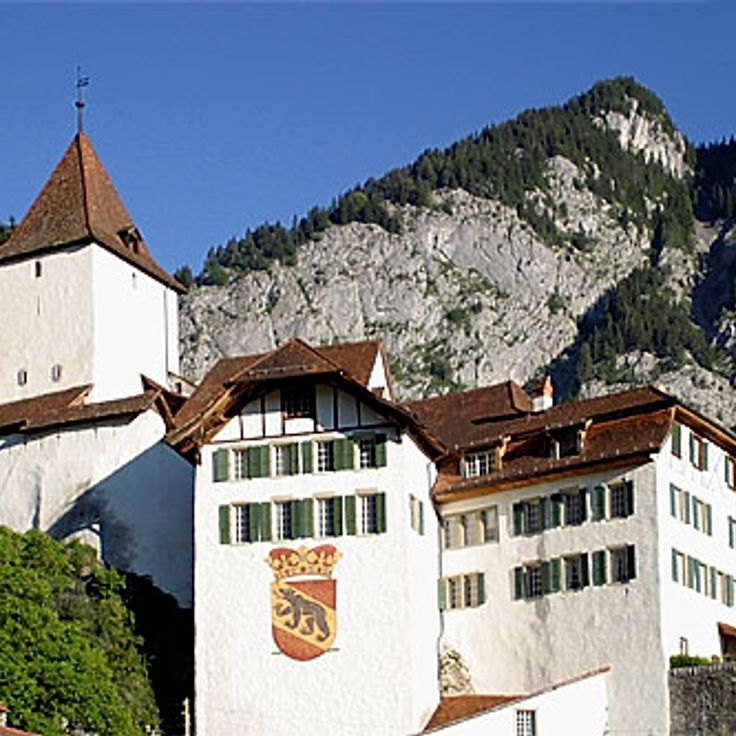
The Château de Wimmis stands on a hill above the village since the 13th century and forms a lookout post over the Simmental and Lower Simmental. The castle still shows its medieval tower and defensive walls. From its elevated position, the view opens across meadows, forests and the surrounding Alpine ranges. Hiking trails lead up to the complex, where you can observe the architecture of stone and timber. This place connects history with the landscape of the Bern region, in an area shaped by the rhythm of the Alps.
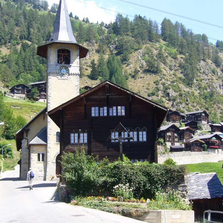
The mountain village of Evolène sits at 4500 feet (1370 m) in the Val d'Hérens valley and features wooden houses, some dating from the 17th century. Narrow lanes wind between darkened facades built from larch and weighted with stone. Locals speak a distinct dialect, and on festival days, especially during the February carnival, some still wear traditional dress. The atmosphere remains quiet, and the surrounding valleys offer access to trails leading toward Arolla and the Ferpècle Glacier.
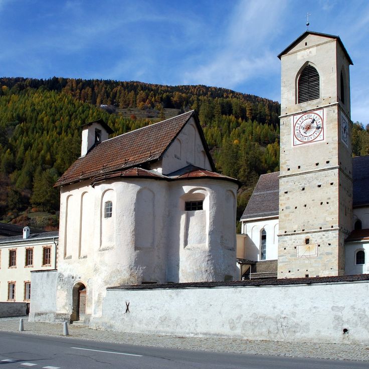
The Benedictine monastery of Saint John in Müstair was founded in the 8th century and still preserves Romanesque wall paintings from the early Middle Ages. The monastery church has three naves with rounded arches and narrow windows typical of medieval construction. Inside the crypt and the church, fragments of frescoes show biblical scenes and figures of saints painted over a thousand years ago. The monastery stands in Val Müstair, a remote valley near the Italian border. Few tourists make their way here, and the silence of the mountains surrounds the old walls. The monastery was never completely destroyed, and some of the original structures from the Carolingian period remain. Today, Benedictine sisters still live in the monastery, which also serves as a museum and place of retreat.
Guarda is a mountain village in the Lower Engadine where old houses show the traditional building style of the region. The facades carry sgraffito decorations, a technique where motifs are scratched into the plaster. The village sits on a plateau above the Inn River and served as the setting for the story of Schellen-Ursli, a well-known Swiss children's book. Narrow lanes run between stone walls and fountains, the houses have thick walls and small windows.
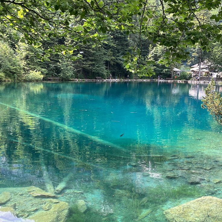
The blue lake near Bern formed after a landslide in 1947, which created a natural dam. The water appears turquoise because of fine mineral particles that reflect sunlight. Spruce trees grow around it on uneven terrain shaped by the movement of rock masses. You can reach it on foot from Kandersteg in about twenty minutes. In summer the water is cold, in winter the surface sometimes freezes. The place draws walkers who prefer short routes.
Alp Flix is a high plateau at around 6500 feet (2000 meters) above sea level, shaped by open alpine meadows, bogs and a diverse range of plants and animals. The landscape results from years of alpine farming and offers a quiet place for walking and observing.
The Twannbachschlucht guides walkers along a narrow stream that cuts through pale limestone walls. Wooden walkways follow the creek while small waterfalls spill over mossy rocks. The path winds between steep cliffs where the sound of water echoes in the tight space. Ferns grow in damp crevices, and light filters down through the tree canopy above. This natural passage connects two mountain slopes and offers a quiet way through the folded geology of the region.
This museum preserves glass artworks from the Middle Ages to the present day, including church windows and painted glass. The collection features liturgical stained glass from different centuries, displayed in the rooms of a historic building. Visitors discover techniques such as glass painting and glass cutting that have been used over time. The exhibited pieces show how religious and secular motifs were transferred onto glass. The permanent exhibition is complemented by temporary exhibitions focusing on contemporary glass design.
This former course of the Aare River now forms a lake surrounded by reed beds and a riparian forest. Waterfowl such as ducks, herons, and kingfishers use the area for nesting and resting. The wet shores attract amphibians and dragonflies, while trees cast shade over the calm water and provide coolness in summer.
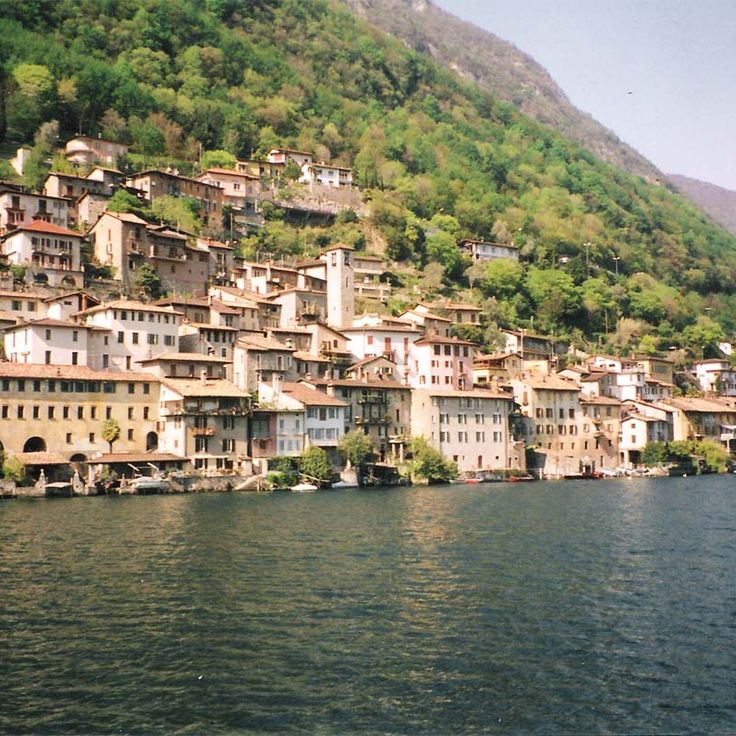
This Ticino village sits on the eastern shore of Lake Lugano. Old stone houses with colored shutters cling to the slope and form narrow lanes that wind down to the waterline. Laundry lines stretch between the walls, and small boats moor along the shore. The quiet here is broken by lakeside bird calls and the soft lapping of water. Some residents maintain small gardens on terraced steps, and you often see cats dozing in the sun. In summer, hikers eat on stone benches along the lakeside path that connects Gandria to Lugano.
Bettmeralp sits at 6,500 feet (2,000 meters) above sea level in Valais and remains car-free all year. The only way in is by cable car from the valley. Mountain scenery from the Aletsch region surrounds the village, and the trails wind through forests of Swiss stone pine and larch. Hikers follow routes that lead toward the glacier or along the southern slopes. The air is dry, the light is sharp, and quietness shapes the mood. A few wooden houses stand beside newer chalets. This mountain village shows how people live at high altitude, without any road connecting it to the outside.
This meadow on the shore of Lake Lucerne is considered the founding site of the Swiss Confederation. In August 1291, representatives from Uri, Schwyz, and Unterwalden met here to form an alliance. The meadow remains a symbol of the beginnings of Switzerland and lies in a quiet stretch of the lake, accessible only on foot or by boat. A memorial stone recalls the event. Trees and grass surround the Rütli, and walking paths run along the shore.
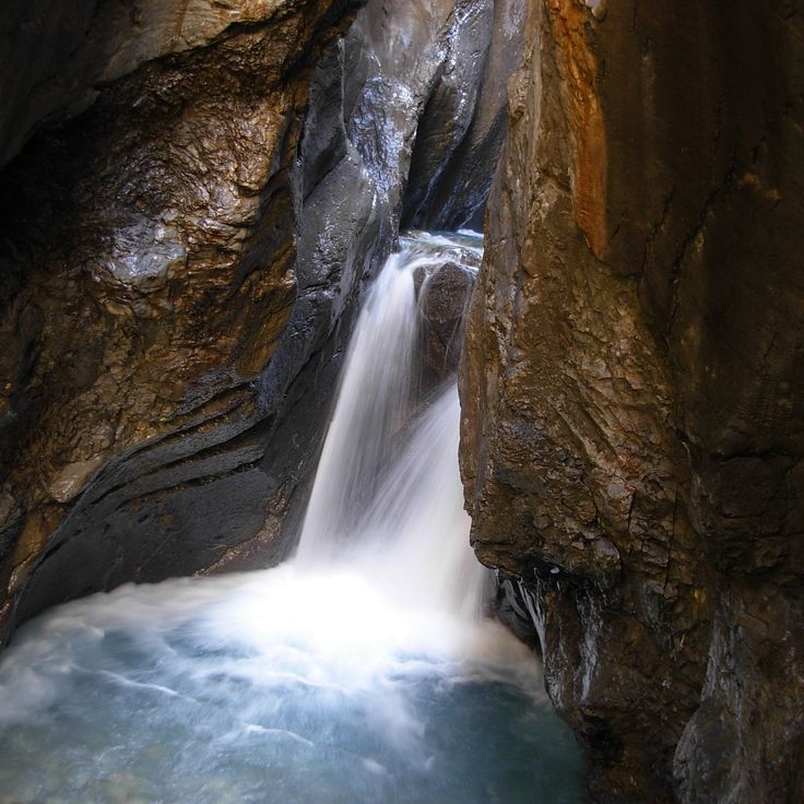
The gorge at Rosenlaui was carved by a glacier over thousands of years, as ice and water wore away limestone and rock. You walk here between tall, smooth walls while water rushes below. Metal walkways and short tunnels guide you through the narrow passages, where light falls from above and makes the wet stone glow. The air is cool, and the sound of water echoes everywhere. In some places the gorge is so tight you could almost touch both walls. This place shows how glaciers shape the land over time.
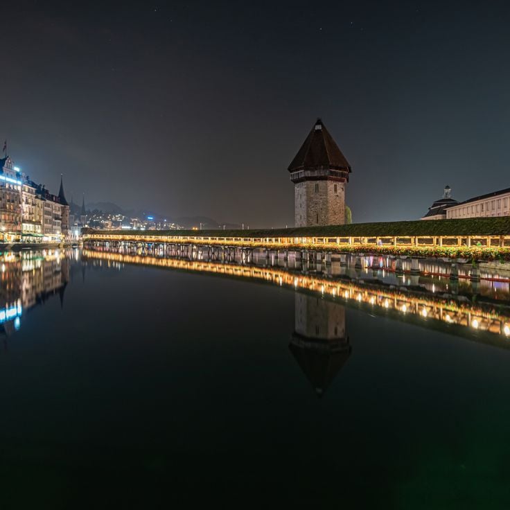
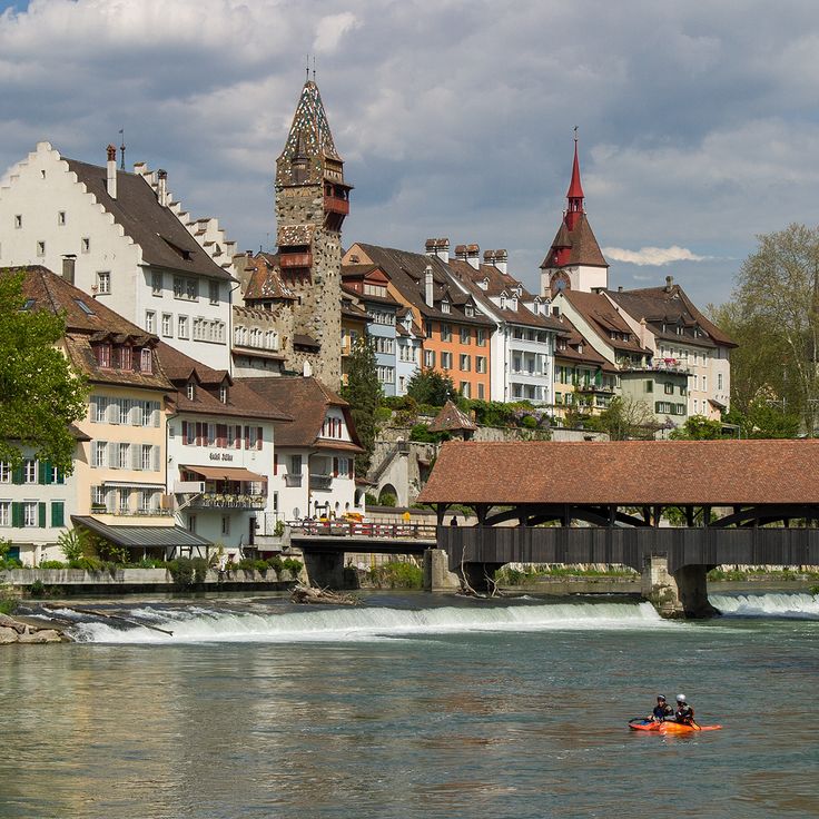
This 204-meter wooden bridge from 1333 crosses the Reuss. Inside hang paintings from the 17th century showing scenes from Swiss history. The bridge connects the old town with the new town and is part of daily life in the city. You walk under a roof, past the old painted panels, while the water moves below. The octagonal water tower stands in the middle of the river and once belonged to the city fortifications. The bridge was partly destroyed by fire in 1993 and rebuilt afterward. Today locals and travelers use it to cross the river and take in views of the city and the mountains behind it.
The church of Saint Martin in Zillis has a painted wooden ceiling from the 12th century, made up of 153 panels. They show scenes from the Bible alongside medieval figures such as saints, monsters, and people from everyday life. The wood was painted directly without a primer. Looking up, a visitor sees a checkerboard sky forming one of the oldest surviving painted ceilings in Europe. Light enters softly through narrow windows, warming the faded colors. The room feels quiet and small, with rows of wooden benches close together. The church sits in a mountain village in the Surselva valley, surrounded by meadows and forests, and has drawn pilgrims and art lovers for centuries.
The town of Brunnen sits on a bay of Lake Lucerne, where the water narrows into the Urnersee. From the promenade you can see the Rütli meadow on the opposite shore, the place where representatives of the three founding cantons are said to have met in 1291. Trails lead along the lake, into the surrounding hills, and to places tied to the founding legend of Switzerland. The water is clear, mountains rise steeply on both sides, and steamboats dock regularly at the pier.
The center of Bremgarten retains its medieval layout. The old town is enclosed by defensive walls and towers built from the 13th century onward. Five gates still lead into the narrow streets today. Inside, houses from different centuries stand side by side, some with bay windows and painted facades. Two churches mark the townscape. The Reuss River flows directly along the edge of the old town, and a historic wooden bridge connects both banks.
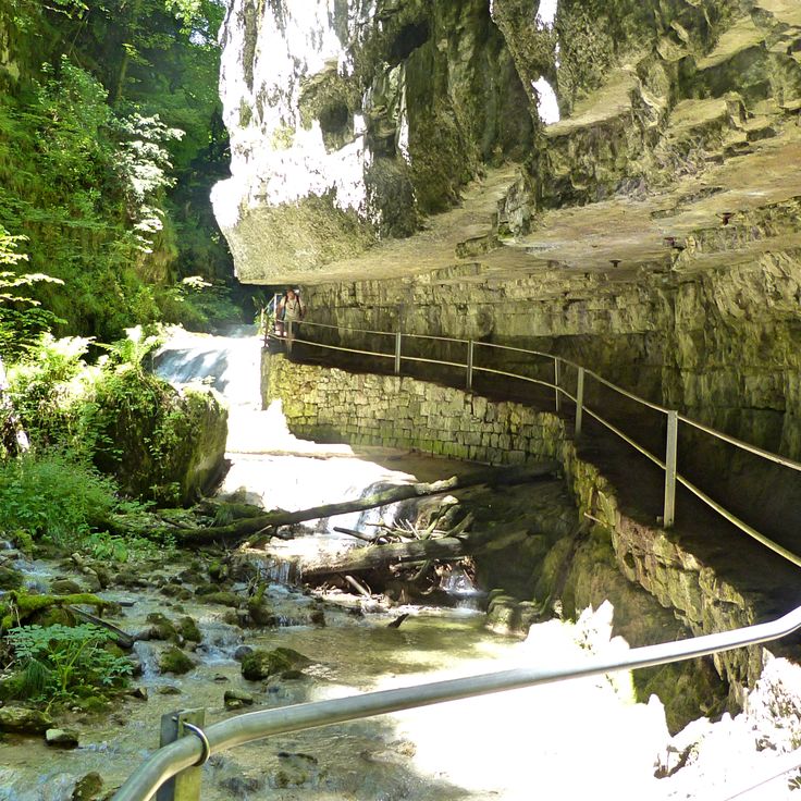
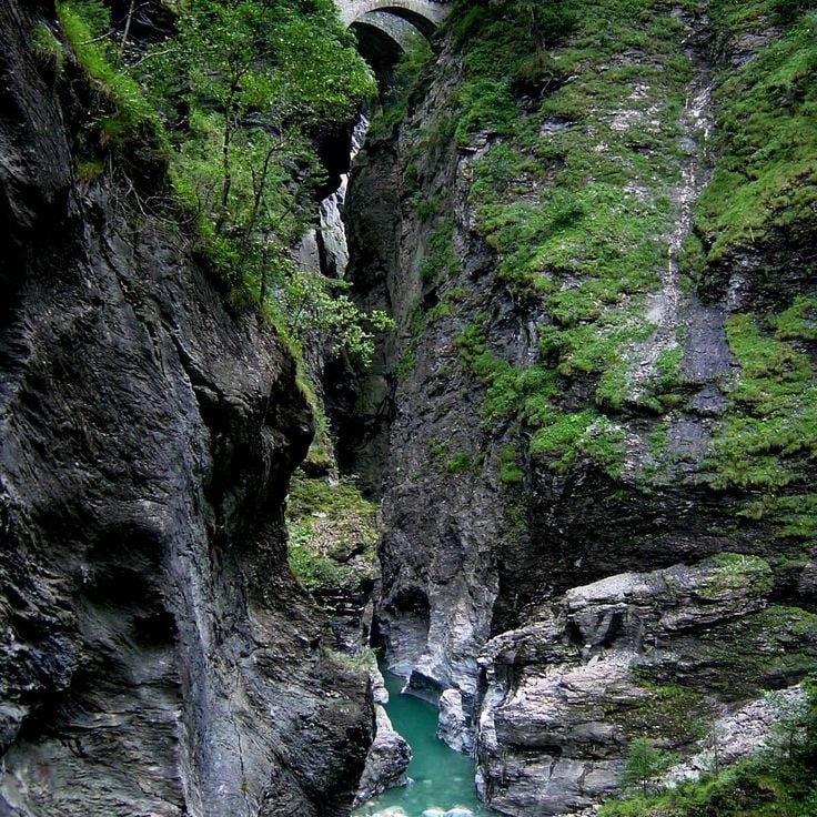
The Viamala gorge cuts 300 meters deep into the rock and follows the course of the Hinterrhein river. For centuries a trade route through the Alps ran here, connecting merchants and travelers between north and south. Today visitors walk along footbridges and stairs that cling to the cliff walls, passing narrow passages and flowing waterfalls. Light reaches the bottom only in a few places, and the air is cool and damp. The trail descends deep into the gorge, where the water roars loudly and the steep gray rock walls shape the landscape. Old bridges recall the long history of this route as a link between regions.
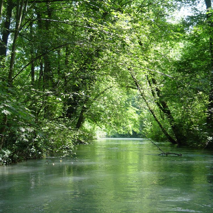
The Thur flows through this valley from the Säntis massif to the Rhine. The river runs largely without dams and follows its natural meanders. Walking paths trace the banks, farm roads cross meadows and small villages. You see gravel beds, shallow spots for wading, and shady stretches under trees. The landscape shifts between open fields and forested slopes. On warm days locals come to swim or picnic by the water.
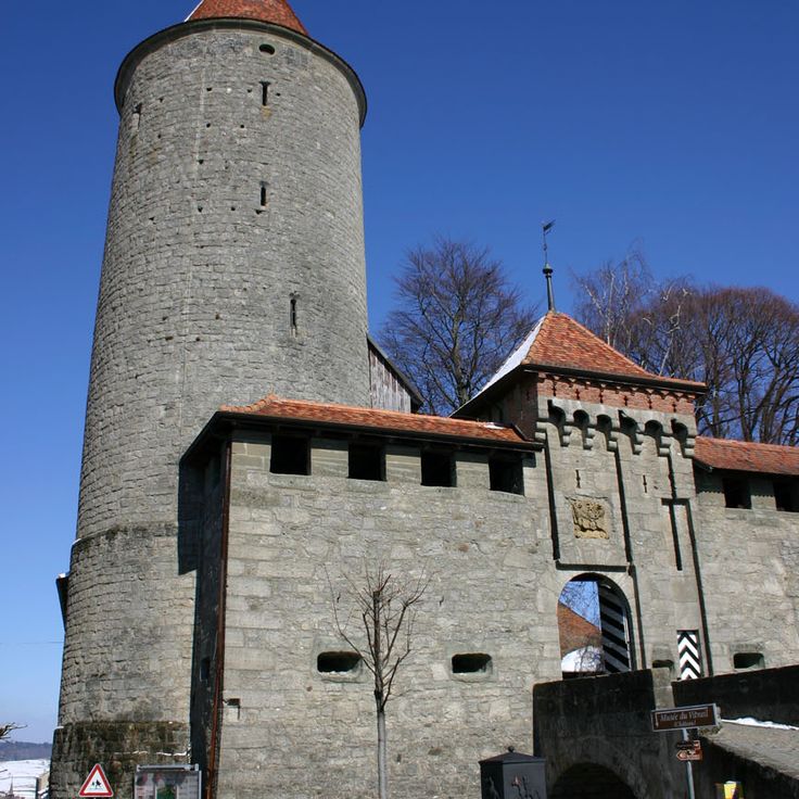
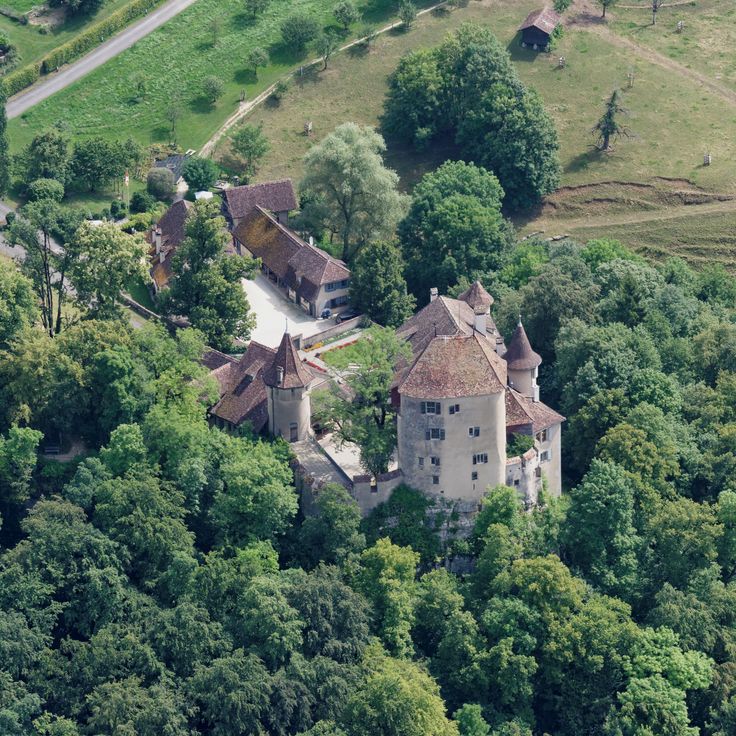
Wildenstein Castle has stood on a steep limestone cliff since the 13th century, overlooking the Delsberger basin. A hiking trail through wooded slopes leads to the top. Once there, you find a residential tower, remnants of walls, and viewing platforms. The view stretches far across the surrounding valleys and Jura heights. The castle is uninhabited but freely accessible. It sits quietly, without tourist facilities. Most visitors hike from Bubendorf or Hölstein and combine the castle visit with a longer loop. The site is small, but the walk and the view are worthwhile.
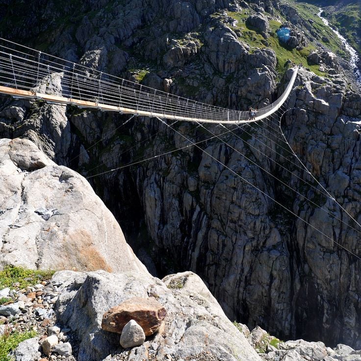
The Trift suspension bridge connects two rocky slopes above a glacial stream that flows from the retreating Trift Glacier. The structure hangs on steel cables about 330 feet (100 meters) above the ground, and the walkway sways slightly in the wind as people cross. From the bridge, you can see waterfalls running down bare rock and hear the sound of meltwater rushing far below. Hikers use the bridge as part of a loop trail that leads to the Trift mountain hut, which sits above the gorge. Access is either on foot or by gondola lift from Trift. In summer, the bridge is busy during the day, though mornings and late afternoons see fewer visitors. The surrounding landscape is made of gray stone, loose rubble, and ice, still adjusting to the glacier's retreat.
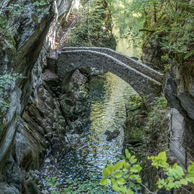
This 19th-century stone bridge connects two rock faces over the Areuse River. It was built 20 meters (65 feet) above the water in the gorge where the river flows between tall limestone walls. The construction made it possible to cross the valley, which was previously difficult to reach. Today the bridge is part of a hiking trail that passes through the narrow sections of the gorge. The water rushes loudly through the tight riverbed, and the rock walls let little daylight through. The surroundings are damp and cool, with moss covering the stones and thick vegetation along the banks.
The Berggasthaus Aescher-Wildkirchli is a mountain guesthouse built directly into a rock face at 4770 feet (1454 meters) above sea level. The house is more than 170 years old and provides shelter for hikers and visitors in the Appenzell Alps. From here you can see the valleys and mountains of the region, and the building itself looks like part of the cliff. The location is remote, and you can only reach the guesthouse on foot. There is a terrace where you can enjoy the view, and inside everything is simple, as is typical for a mountain guesthouse.
The waterfalls in the Lauterbrunnen Valley are among the landmarks of the Swiss Alps. A total of 72 cascades drop from limestone walls that rise 300 meters (984 feet) into the air. The most famous are Staubbach Falls and Trümmelbach Falls, which flow inside the mountain through rock gorges. The valley is bordered by steep walls, between which meadows and small villages stretch out. You can hear the sound of water from almost anywhere. The falls are accessible on foot or by train, and several hiking trails run through the landscape. In summer, the meltwater flows particularly strong, while in winter icicles form on the rocks. This place shows the power of nature in one of the deepest valleys in the Alps.
Monte San Giorgio holds one of the most complete fossil collections from the Middle Triassic period ever discovered. On the slopes of this mountain in Ticino, fossilized remains of marine life that existed 240 million years ago in a subtropical sea are preserved in layers of rock. The site contains remains of marine reptiles, fish, and invertebrates whose exceptional preservation allows for scientific research at the highest level. Access to these geological layers is now possible through educational trails that explain the formations and offer a view into a vanished world. The fossil sites lie among forests and alpine meadows that attract hikers and fossil enthusiasts during the summer months.
The Basilica of Valère is a Romanesque church from the 11th century standing on a hill above the town of Sion. It was built as a fortified church, surrounded by defensive walls that remain visible today. Inside, one of the oldest playable organs in the world dates from the 15th century and is used for concerts. The church displays frescoes on the walls and a wooden ceiling preserved over the centuries. From the terrace, the Rhone Valley and surrounding mountains come into view. The climb to the basilica follows a paved path winding through the old town.
Caumasee sits in a hollow at 3,300 feet (1,000 meters) elevation, surrounded by fir forest. The water is mineralized and the lake reaches a depth of 50 feet (15 meters). In summer the water warms thanks to the sheltered position, and families come to swim and picnic. A path runs through the forest around the shore, and several wooden piers extend into the water. The atmosphere is quiet, with light filtering through the trees onto the surface, which shimmers turquoise. In winter the lake sometimes freezes over completely.
The village sits at 4510 feet (1375 meters) in the Müstair valley, near the Italian border, where Romansh is still spoken today. Santa Maria preserves a Romanesque monastery from the 8th century, its church decorated with medieval wall paintings. The frescoes have been reworked over centuries and depict biblical scenes in bright colors. The monastery was founded by Charlemagne and attracted pilgrims traveling over the Ofen Pass. The surroundings consist of meadows, forests, and mountain slopes that carry snow in winter and are crossed by hiking trails in summer.
This rock basin in the Neuchâtel Jura has walls that rise up to 525 feet (160 meters) and stretches over a kilometer wide. Ibex and chamois move freely here in a protected area that belongs to the region's nature reserves. Hiking trails lead to the upper rim of the walls, where you can look down into the depth and often observe wildlife climbing steep slopes or resting on the rocks.
Binntal is a high mountain valley in Valais Canton, known for its mineral deposits. Over 300 different mineral species occur in this region. Along the hiking trails, old tunnels and mine shafts recall the area's mining past. The landscape consists of steep rock walls, scree slopes, and mountain streams. Marked paths allow visitors to explore the geological history of the Alps and follow traces of human mining activity from past centuries.
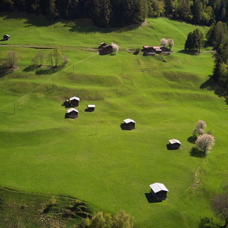
This mountain farm sits at 5610 feet (1711 meters) in the Engadine region. It combines overnight accommodation with traditional alpine farming, showing how mountain agriculture still works in the Alps. Guests can stay in simple rooms while the farmers tend their animals, harvest hay, and make cheese. The location provides access to walking paths in the area, where grazing fields reach up to the rock faces.
Vallon de Réchy is an alpine valley in Valais that has remained without trails, huts, or tourism facilities. A meandering stream runs through the valley floor, surrounded by meadows and pastures where rare plant species grow. The area is reached on foot from surrounding villages and is protected as a nature reserve. Vegetation follows the seasons without human interference, and the water maintains its natural course. Hikers find here a valley that has changed little over time, offering quiet for extended observation.
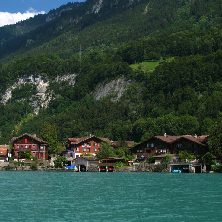
Iseltwald sits on the southern shore of Lake Brienz. The village developed through fishing and timber trade. Old wooden houses and narrow lanes still shape its appearance. A medieval castle stands by the water. You can walk along the lake, explore quiet coves and see forested slopes dropping straight into the turquoise water. In summer, boats dock at the small harbor. The atmosphere is calm, with few visitors. Iseltwald feels like a village that has kept its rhythm, away from the busier places around Interlaken. The light on the water shifts throughout the day, and the sound of the lake is often the only thing you hear.
Art Goldau combines a zoo with a sculpture trail on land shaped by a landslide in 1806. Contemporary artworks stand among trees, rocks, and paths where visitors encounter deer, wolves, and wild boar. The connection between nature, animals, and art defines this place, which covers several acres and invites walking. Some sculptures are made of wood, others of metal or stone. You follow a trail that winds through forest and open areas, past enclosures and installations. The site preserves traces of the natural disaster and shows how landscape and life have evolved since then.
This concrete wall was built in the 1960s to generate electricity for the Ticino region. From the top, you fall 220 meters (722 feet) into the void: the structure serves as a base for bungee jumping, an activity that grew after the GoldenEye film. The dam sits between steep slopes, and the turquoise lake behind it attracts visitors walking through the valley. From the crest, you see the entire Verzasca Valley, its water pooling far below. The contrast between the gray wall and the clear water is impressive, especially when you approach the dam from below.
Château de Chillon stands on a rocky island in Lake Geneva, linked to the shore by a wooden bridge. The first mention of the castle dates to the 12th century. From a distance, you can see the defense towers, thick stone walls, and roofs covered with dark slate. Inside, you pass through courtyards, vaulted cellars, and halls with carved wooden ceilings. Lord Byron visited in the 19th century and left his signature on a pillar in the dungeon. From the lakeshore, the Vaud Alps rise in the background. The castle has kept its medieval layout and fortifications. It shows how a border stronghold worked on the water.
The Château de Wimmis stands on a hill above the village since the 13th century and forms a lookout post over the Simmental and Lower Simmental. The castle still shows its medieval tower and defensive walls. From its elevated position, the view opens across meadows, forests and the surrounding Alpine ranges. Hiking trails lead up to the complex, where you can observe the architecture of stone and timber. This place connects history with the landscape of the Bern region, in an area shaped by the rhythm of the Alps.
The mountain village of Evolène sits at 4500 feet (1370 m) in the Val d'Hérens valley and features wooden houses, some dating from the 17th century. Narrow lanes wind between darkened facades built from larch and weighted with stone. Locals speak a distinct dialect, and on festival days, especially during the February carnival, some still wear traditional dress. The atmosphere remains quiet, and the surrounding valleys offer access to trails leading toward Arolla and the Ferpècle Glacier.
The Benedictine monastery of Saint John in Müstair was founded in the 8th century and still preserves Romanesque wall paintings from the early Middle Ages. The monastery church has three naves with rounded arches and narrow windows typical of medieval construction. Inside the crypt and the church, fragments of frescoes show biblical scenes and figures of saints painted over a thousand years ago. The monastery stands in Val Müstair, a remote valley near the Italian border. Few tourists make their way here, and the silence of the mountains surrounds the old walls. The monastery was never completely destroyed, and some of the original structures from the Carolingian period remain. Today, Benedictine sisters still live in the monastery, which also serves as a museum and place of retreat.
Guarda is a mountain village in the Lower Engadine where old houses show the traditional building style of the region. The facades carry sgraffito decorations, a technique where motifs are scratched into the plaster. The village sits on a plateau above the Inn River and served as the setting for the story of Schellen-Ursli, a well-known Swiss children's book. Narrow lanes run between stone walls and fountains, the houses have thick walls and small windows.
The blue lake near Bern formed after a landslide in 1947, which created a natural dam. The water appears turquoise because of fine mineral particles that reflect sunlight. Spruce trees grow around it on uneven terrain shaped by the movement of rock masses. You can reach it on foot from Kandersteg in about twenty minutes. In summer the water is cold, in winter the surface sometimes freezes. The place draws walkers who prefer short routes.
Alp Flix is a high plateau at around 6500 feet (2000 meters) above sea level, shaped by open alpine meadows, bogs and a diverse range of plants and animals. The landscape results from years of alpine farming and offers a quiet place for walking and observing.
The Twannbachschlucht guides walkers along a narrow stream that cuts through pale limestone walls. Wooden walkways follow the creek while small waterfalls spill over mossy rocks. The path winds between steep cliffs where the sound of water echoes in the tight space. Ferns grow in damp crevices, and light filters down through the tree canopy above. This natural passage connects two mountain slopes and offers a quiet way through the folded geology of the region.
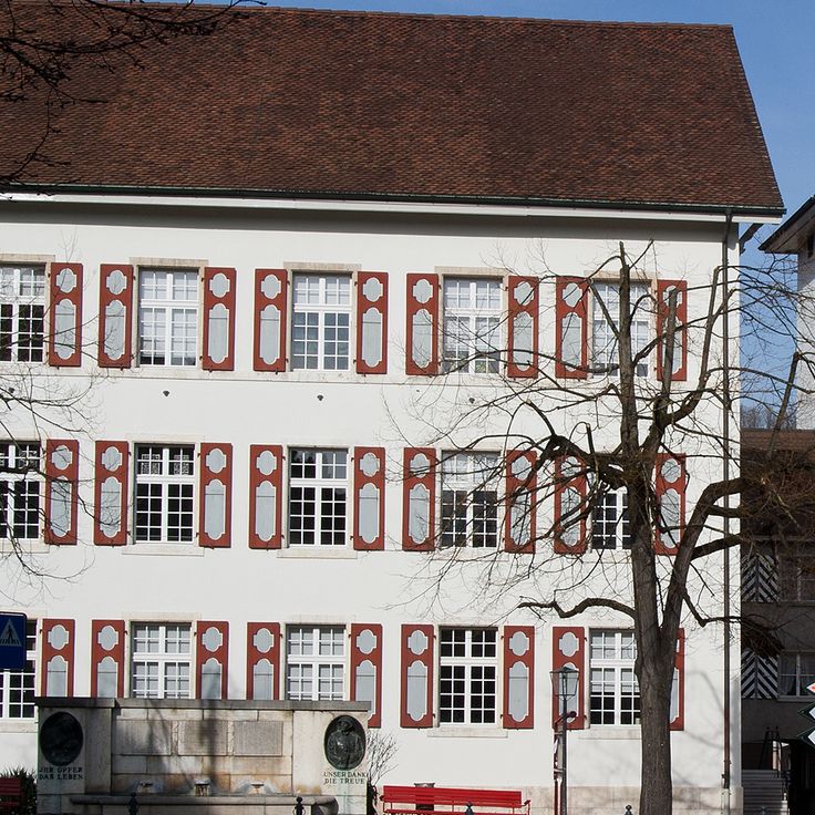
This museum preserves glass artworks from the Middle Ages to the present day, including church windows and painted glass. The collection features liturgical stained glass from different centuries, displayed in the rooms of a historic building. Visitors discover techniques such as glass painting and glass cutting that have been used over time. The exhibited pieces show how religious and secular motifs were transferred onto glass. The permanent exhibition is complemented by temporary exhibitions focusing on contemporary glass design.
This former course of the Aare River now forms a lake surrounded by reed beds and a riparian forest. Waterfowl such as ducks, herons, and kingfishers use the area for nesting and resting. The wet shores attract amphibians and dragonflies, while trees cast shade over the calm water and provide coolness in summer.
This Ticino village sits on the eastern shore of Lake Lugano. Old stone houses with colored shutters cling to the slope and form narrow lanes that wind down to the waterline. Laundry lines stretch between the walls, and small boats moor along the shore. The quiet here is broken by lakeside bird calls and the soft lapping of water. Some residents maintain small gardens on terraced steps, and you often see cats dozing in the sun. In summer, hikers eat on stone benches along the lakeside path that connects Gandria to Lugano.
Bettmeralp sits at 6,500 feet (2,000 meters) above sea level in Valais and remains car-free all year. The only way in is by cable car from the valley. Mountain scenery from the Aletsch region surrounds the village, and the trails wind through forests of Swiss stone pine and larch. Hikers follow routes that lead toward the glacier or along the southern slopes. The air is dry, the light is sharp, and quietness shapes the mood. A few wooden houses stand beside newer chalets. This mountain village shows how people live at high altitude, without any road connecting it to the outside.
This meadow on the shore of Lake Lucerne is considered the founding site of the Swiss Confederation. In August 1291, representatives from Uri, Schwyz, and Unterwalden met here to form an alliance. The meadow remains a symbol of the beginnings of Switzerland and lies in a quiet stretch of the lake, accessible only on foot or by boat. A memorial stone recalls the event. Trees and grass surround the Rütli, and walking paths run along the shore.
The gorge at Rosenlaui was carved by a glacier over thousands of years, as ice and water wore away limestone and rock. You walk here between tall, smooth walls while water rushes below. Metal walkways and short tunnels guide you through the narrow passages, where light falls from above and makes the wet stone glow. The air is cool, and the sound of water echoes everywhere. In some places the gorge is so tight you could almost touch both walls. This place shows how glaciers shape the land over time.
This 204-meter wooden bridge from 1333 crosses the Reuss. Inside hang paintings from the 17th century showing scenes from Swiss history. The bridge connects the old town with the new town and is part of daily life in the city. You walk under a roof, past the old painted panels, while the water moves below. The octagonal water tower stands in the middle of the river and once belonged to the city fortifications. The bridge was partly destroyed by fire in 1993 and rebuilt afterward. Today locals and travelers use it to cross the river and take in views of the city and the mountains behind it.
The church of Saint Martin in Zillis has a painted wooden ceiling from the 12th century, made up of 153 panels. They show scenes from the Bible alongside medieval figures such as saints, monsters, and people from everyday life. The wood was painted directly without a primer. Looking up, a visitor sees a checkerboard sky forming one of the oldest surviving painted ceilings in Europe. Light enters softly through narrow windows, warming the faded colors. The room feels quiet and small, with rows of wooden benches close together. The church sits in a mountain village in the Surselva valley, surrounded by meadows and forests, and has drawn pilgrims and art lovers for centuries.
The town of Brunnen sits on a bay of Lake Lucerne, where the water narrows into the Urnersee. From the promenade you can see the Rütli meadow on the opposite shore, the place where representatives of the three founding cantons are said to have met in 1291. Trails lead along the lake, into the surrounding hills, and to places tied to the founding legend of Switzerland. The water is clear, mountains rise steeply on both sides, and steamboats dock regularly at the pier.
The center of Bremgarten retains its medieval layout. The old town is enclosed by defensive walls and towers built from the 13th century onward. Five gates still lead into the narrow streets today. Inside, houses from different centuries stand side by side, some with bay windows and painted facades. Two churches mark the townscape. The Reuss River flows directly along the edge of the old town, and a historic wooden bridge connects both banks.
The Viamala gorge cuts 300 meters deep into the rock and follows the course of the Hinterrhein river. For centuries a trade route through the Alps ran here, connecting merchants and travelers between north and south. Today visitors walk along footbridges and stairs that cling to the cliff walls, passing narrow passages and flowing waterfalls. Light reaches the bottom only in a few places, and the air is cool and damp. The trail descends deep into the gorge, where the water roars loudly and the steep gray rock walls shape the landscape. Old bridges recall the long history of this route as a link between regions.
The Thur flows through this valley from the Säntis massif to the Rhine. The river runs largely without dams and follows its natural meanders. Walking paths trace the banks, farm roads cross meadows and small villages. You see gravel beds, shallow spots for wading, and shady stretches under trees. The landscape shifts between open fields and forested slopes. On warm days locals come to swim or picnic by the water.
Wildenstein Castle has stood on a steep limestone cliff since the 13th century, overlooking the Delsberger basin. A hiking trail through wooded slopes leads to the top. Once there, you find a residential tower, remnants of walls, and viewing platforms. The view stretches far across the surrounding valleys and Jura heights. The castle is uninhabited but freely accessible. It sits quietly, without tourist facilities. Most visitors hike from Bubendorf or Hölstein and combine the castle visit with a longer loop. The site is small, but the walk and the view are worthwhile.
The Trift suspension bridge connects two rocky slopes above a glacial stream that flows from the retreating Trift Glacier. The structure hangs on steel cables about 330 feet (100 meters) above the ground, and the walkway sways slightly in the wind as people cross. From the bridge, you can see waterfalls running down bare rock and hear the sound of meltwater rushing far below. Hikers use the bridge as part of a loop trail that leads to the Trift mountain hut, which sits above the gorge. Access is either on foot or by gondola lift from Trift. In summer, the bridge is busy during the day, though mornings and late afternoons see fewer visitors. The surrounding landscape is made of gray stone, loose rubble, and ice, still adjusting to the glacier's retreat.
This 19th-century stone bridge connects two rock faces over the Areuse River. It was built 20 meters (65 feet) above the water in the gorge where the river flows between tall limestone walls. The construction made it possible to cross the valley, which was previously difficult to reach. Today the bridge is part of a hiking trail that passes through the narrow sections of the gorge. The water rushes loudly through the tight riverbed, and the rock walls let little daylight through. The surroundings are damp and cool, with moss covering the stones and thick vegetation along the banks.
The Berggasthaus Aescher-Wildkirchli is a mountain guesthouse built directly into a rock face at 4770 feet (1454 meters) above sea level. The house is more than 170 years old and provides shelter for hikers and visitors in the Appenzell Alps. From here you can see the valleys and mountains of the region, and the building itself looks like part of the cliff. The location is remote, and you can only reach the guesthouse on foot. There is a terrace where you can enjoy the view, and inside everything is simple, as is typical for a mountain guesthouse.
The waterfalls in the Lauterbrunnen Valley are among the landmarks of the Swiss Alps. A total of 72 cascades drop from limestone walls that rise 300 meters (984 feet) into the air. The most famous are Staubbach Falls and Trümmelbach Falls, which flow inside the mountain through rock gorges. The valley is bordered by steep walls, between which meadows and small villages stretch out. You can hear the sound of water from almost anywhere. The falls are accessible on foot or by train, and several hiking trails run through the landscape. In summer, the meltwater flows particularly strong, while in winter icicles form on the rocks. This place shows the power of nature in one of the deepest valleys in the Alps.
Monte San Giorgio holds one of the most complete fossil collections from the Middle Triassic period ever discovered. On the slopes of this mountain in Ticino, fossilized remains of marine life that existed 240 million years ago in a subtropical sea are preserved in layers of rock. The site contains remains of marine reptiles, fish, and invertebrates whose exceptional preservation allows for scientific research at the highest level. Access to these geological layers is now possible through educational trails that explain the formations and offer a view into a vanished world. The fossil sites lie among forests and alpine meadows that attract hikers and fossil enthusiasts during the summer months.
The Basilica of Valère is a Romanesque church from the 11th century standing on a hill above the town of Sion. It was built as a fortified church, surrounded by defensive walls that remain visible today. Inside, one of the oldest playable organs in the world dates from the 15th century and is used for concerts. The church displays frescoes on the walls and a wooden ceiling preserved over the centuries. From the terrace, the Rhone Valley and surrounding mountains come into view. The climb to the basilica follows a paved path winding through the old town.
Caumasee sits in a hollow at 3,300 feet (1,000 meters) elevation, surrounded by fir forest. The water is mineralized and the lake reaches a depth of 50 feet (15 meters). In summer the water warms thanks to the sheltered position, and families come to swim and picnic. A path runs through the forest around the shore, and several wooden piers extend into the water. The atmosphere is quiet, with light filtering through the trees onto the surface, which shimmers turquoise. In winter the lake sometimes freezes over completely.
The village sits at 4510 feet (1375 meters) in the Müstair valley, near the Italian border, where Romansh is still spoken today. Santa Maria preserves a Romanesque monastery from the 8th century, its church decorated with medieval wall paintings. The frescoes have been reworked over centuries and depict biblical scenes in bright colors. The monastery was founded by Charlemagne and attracted pilgrims traveling over the Ofen Pass. The surroundings consist of meadows, forests, and mountain slopes that carry snow in winter and are crossed by hiking trails in summer.
This rock basin in the Neuchâtel Jura has walls that rise up to 525 feet (160 meters) and stretches over a kilometer wide. Ibex and chamois move freely here in a protected area that belongs to the region's nature reserves. Hiking trails lead to the upper rim of the walls, where you can look down into the depth and often observe wildlife climbing steep slopes or resting on the rocks.
Binntal is a high mountain valley in Valais Canton, known for its mineral deposits. Over 300 different mineral species occur in this region. Along the hiking trails, old tunnels and mine shafts recall the area's mining past. The landscape consists of steep rock walls, scree slopes, and mountain streams. Marked paths allow visitors to explore the geological history of the Alps and follow traces of human mining activity from past centuries.
This mountain farm sits at 5610 feet (1711 meters) in the Engadine region. It combines overnight accommodation with traditional alpine farming, showing how mountain agriculture still works in the Alps. Guests can stay in simple rooms while the farmers tend their animals, harvest hay, and make cheese. The location provides access to walking paths in the area, where grazing fields reach up to the rock faces.
Vallon de Réchy is an alpine valley in Valais that has remained without trails, huts, or tourism facilities. A meandering stream runs through the valley floor, surrounded by meadows and pastures where rare plant species grow. The area is reached on foot from surrounding villages and is protected as a nature reserve. Vegetation follows the seasons without human interference, and the water maintains its natural course. Hikers find here a valley that has changed little over time, offering quiet for extended observation.
Iseltwald sits on the southern shore of Lake Brienz. The village developed through fishing and timber trade. Old wooden houses and narrow lanes still shape its appearance. A medieval castle stands by the water. You can walk along the lake, explore quiet coves and see forested slopes dropping straight into the turquoise water. In summer, boats dock at the small harbor. The atmosphere is calm, with few visitors. Iseltwald feels like a village that has kept its rhythm, away from the busier places around Interlaken. The light on the water shifts throughout the day, and the sound of the lake is often the only thing you hear.
Art Goldau combines a zoo with a sculpture trail on land shaped by a landslide in 1806. Contemporary artworks stand among trees, rocks, and paths where visitors encounter deer, wolves, and wild boar. The connection between nature, animals, and art defines this place, which covers several acres and invites walking. Some sculptures are made of wood, others of metal or stone. You follow a trail that winds through forest and open areas, past enclosures and installations. The site preserves traces of the natural disaster and shows how landscape and life have evolved since then.
This concrete wall was built in the 1960s to generate electricity for the Ticino region. From the top, you fall 220 meters (722 feet) into the void: the structure serves as a base for bungee jumping, an activity that grew after the GoldenEye film. The dam sits between steep slopes, and the turquoise lake behind it attracts visitors walking through the valley. From the crest, you see the entire Verzasca Valley, its water pooling far below. The contrast between the gray wall and the clear water is impressive, especially when you approach the dam from below.
Château de Chillon stands on a rocky island in Lake Geneva, linked to the shore by a wooden bridge. The first mention of the castle dates to the 12th century. From a distance, you can see the defense towers, thick stone walls, and roofs covered with dark slate. Inside, you pass through courtyards, vaulted cellars, and halls with carved wooden ceilings. Lord Byron visited in the 19th century and left his signature on a pillar in the dungeon. From the lakeshore, the Vaud Alps rise in the background. The castle has kept its medieval layout and fortifications. It shows how a border stronghold worked on the water.
The Château de Wimmis stands on a hill above the village since the 13th century and forms a lookout post over the Simmental and Lower Simmental. The castle still shows its medieval tower and defensive walls. From its elevated position, the view opens across meadows, forests and the surrounding Alpine ranges. Hiking trails lead up to the complex, where you can observe the architecture of stone and timber. This place connects history with the landscape of the Bern region, in an area shaped by the rhythm of the Alps.
The mountain village of Evolène sits at 4500 feet (1370 m) in the Val d'Hérens valley and features wooden houses, some dating from the 17th century. Narrow lanes wind between darkened facades built from larch and weighted with stone. Locals speak a distinct dialect, and on festival days, especially during the February carnival, some still wear traditional dress. The atmosphere remains quiet, and the surrounding valleys offer access to trails leading toward Arolla and the Ferpècle Glacier.
The Benedictine monastery of Saint John in Müstair was founded in the 8th century and still preserves Romanesque wall paintings from the early Middle Ages. The monastery church has three naves with rounded arches and narrow windows typical of medieval construction. Inside the crypt and the church, fragments of frescoes show biblical scenes and figures of saints painted over a thousand years ago. The monastery stands in Val Müstair, a remote valley near the Italian border. Few tourists make their way here, and the silence of the mountains surrounds the old walls. The monastery was never completely destroyed, and some of the original structures from the Carolingian period remain. Today, Benedictine sisters still live in the monastery, which also serves as a museum and place of retreat.
Guarda is a mountain village in the Lower Engadine where old houses show the traditional building style of the region. The facades carry sgraffito decorations, a technique where motifs are scratched into the plaster. The village sits on a plateau above the Inn River and served as the setting for the story of Schellen-Ursli, a well-known Swiss children's book. Narrow lanes run between stone walls and fountains, the houses have thick walls and small windows.
The blue lake near Bern formed after a landslide in 1947, which created a natural dam. The water appears turquoise because of fine mineral particles that reflect sunlight. Spruce trees grow around it on uneven terrain shaped by the movement of rock masses. You can reach it on foot from Kandersteg in about twenty minutes. In summer the water is cold, in winter the surface sometimes freezes. The place draws walkers who prefer short routes.
Alp Flix is a high plateau at around 6500 feet (2000 meters) above sea level, shaped by open alpine meadows, bogs and a diverse range of plants and animals. The landscape results from years of alpine farming and offers a quiet place for walking and observing.
The Twannbachschlucht guides walkers along a narrow stream that cuts through pale limestone walls. Wooden walkways follow the creek while small waterfalls spill over mossy rocks. The path winds between steep cliffs where the sound of water echoes in the tight space. Ferns grow in damp crevices, and light filters down through the tree canopy above. This natural passage connects two mountain slopes and offers a quiet way through the folded geology of the region.
This museum preserves glass artworks from the Middle Ages to the present day, including church windows and painted glass. The collection features liturgical stained glass from different centuries, displayed in the rooms of a historic building. Visitors discover techniques such as glass painting and glass cutting that have been used over time. The exhibited pieces show how religious and secular motifs were transferred onto glass. The permanent exhibition is complemented by temporary exhibitions focusing on contemporary glass design.
This former course of the Aare River now forms a lake surrounded by reed beds and a riparian forest. Waterfowl such as ducks, herons, and kingfishers use the area for nesting and resting. The wet shores attract amphibians and dragonflies, while trees cast shade over the calm water and provide coolness in summer.
This Ticino village sits on the eastern shore of Lake Lugano. Old stone houses with colored shutters cling to the slope and form narrow lanes that wind down to the waterline. Laundry lines stretch between the walls, and small boats moor along the shore. The quiet here is broken by lakeside bird calls and the soft lapping of water. Some residents maintain small gardens on terraced steps, and you often see cats dozing in the sun. In summer, hikers eat on stone benches along the lakeside path that connects Gandria to Lugano.
Bettmeralp sits at 6,500 feet (2,000 meters) above sea level in Valais and remains car-free all year. The only way in is by cable car from the valley. Mountain scenery from the Aletsch region surrounds the village, and the trails wind through forests of Swiss stone pine and larch. Hikers follow routes that lead toward the glacier or along the southern slopes. The air is dry, the light is sharp, and quietness shapes the mood. A few wooden houses stand beside newer chalets. This mountain village shows how people live at high altitude, without any road connecting it to the outside.
This meadow on the shore of Lake Lucerne is considered the founding site of the Swiss Confederation. In August 1291, representatives from Uri, Schwyz, and Unterwalden met here to form an alliance. The meadow remains a symbol of the beginnings of Switzerland and lies in a quiet stretch of the lake, accessible only on foot or by boat. A memorial stone recalls the event. Trees and grass surround the Rütli, and walking paths run along the shore.
The gorge at Rosenlaui was carved by a glacier over thousands of years, as ice and water wore away limestone and rock. You walk here between tall, smooth walls while water rushes below. Metal walkways and short tunnels guide you through the narrow passages, where light falls from above and makes the wet stone glow. The air is cool, and the sound of water echoes everywhere. In some places the gorge is so tight you could almost touch both walls. This place shows how glaciers shape the land over time.
This 204-meter wooden bridge from 1333 crosses the Reuss. Inside hang paintings from the 17th century showing scenes from Swiss history. The bridge connects the old town with the new town and is part of daily life in the city. You walk under a roof, past the old painted panels, while the water moves below. The octagonal water tower stands in the middle of the river and once belonged to the city fortifications. The bridge was partly destroyed by fire in 1993 and rebuilt afterward. Today locals and travelers use it to cross the river and take in views of the city and the mountains behind it.
The church of Saint Martin in Zillis has a painted wooden ceiling from the 12th century, made up of 153 panels. They show scenes from the Bible alongside medieval figures such as saints, monsters, and people from everyday life. The wood was painted directly without a primer. Looking up, a visitor sees a checkerboard sky forming one of the oldest surviving painted ceilings in Europe. Light enters softly through narrow windows, warming the faded colors. The room feels quiet and small, with rows of wooden benches close together. The church sits in a mountain village in the Surselva valley, surrounded by meadows and forests, and has drawn pilgrims and art lovers for centuries.
The town of Brunnen sits on a bay of Lake Lucerne, where the water narrows into the Urnersee. From the promenade you can see the Rütli meadow on the opposite shore, the place where representatives of the three founding cantons are said to have met in 1291. Trails lead along the lake, into the surrounding hills, and to places tied to the founding legend of Switzerland. The water is clear, mountains rise steeply on both sides, and steamboats dock regularly at the pier.
The center of Bremgarten retains its medieval layout. The old town is enclosed by defensive walls and towers built from the 13th century onward. Five gates still lead into the narrow streets today. Inside, houses from different centuries stand side by side, some with bay windows and painted facades. Two churches mark the townscape. The Reuss River flows directly along the edge of the old town, and a historic wooden bridge connects both banks.
The Viamala gorge cuts 300 meters deep into the rock and follows the course of the Hinterrhein river. For centuries a trade route through the Alps ran here, connecting merchants and travelers between north and south. Today visitors walk along footbridges and stairs that cling to the cliff walls, passing narrow passages and flowing waterfalls. Light reaches the bottom only in a few places, and the air is cool and damp. The trail descends deep into the gorge, where the water roars loudly and the steep gray rock walls shape the landscape. Old bridges recall the long history of this route as a link between regions.
The Thur flows through this valley from the Säntis massif to the Rhine. The river runs largely without dams and follows its natural meanders. Walking paths trace the banks, farm roads cross meadows and small villages. You see gravel beds, shallow spots for wading, and shady stretches under trees. The landscape shifts between open fields and forested slopes. On warm days locals come to swim or picnic by the water.
Wildenstein Castle has stood on a steep limestone cliff since the 13th century, overlooking the Delsberger basin. A hiking trail through wooded slopes leads to the top. Once there, you find a residential tower, remnants of walls, and viewing platforms. The view stretches far across the surrounding valleys and Jura heights. The castle is uninhabited but freely accessible. It sits quietly, without tourist facilities. Most visitors hike from Bubendorf or Hölstein and combine the castle visit with a longer loop. The site is small, but the walk and the view are worthwhile.
The Trift suspension bridge connects two rocky slopes above a glacial stream that flows from the retreating Trift Glacier. The structure hangs on steel cables about 330 feet (100 meters) above the ground, and the walkway sways slightly in the wind as people cross. From the bridge, you can see waterfalls running down bare rock and hear the sound of meltwater rushing far below. Hikers use the bridge as part of a loop trail that leads to the Trift mountain hut, which sits above the gorge. Access is either on foot or by gondola lift from Trift. In summer, the bridge is busy during the day, though mornings and late afternoons see fewer visitors. The surrounding landscape is made of gray stone, loose rubble, and ice, still adjusting to the glacier's retreat.
This 19th-century stone bridge connects two rock faces over the Areuse River. It was built 20 meters (65 feet) above the water in the gorge where the river flows between tall limestone walls. The construction made it possible to cross the valley, which was previously difficult to reach. Today the bridge is part of a hiking trail that passes through the narrow sections of the gorge. The water rushes loudly through the tight riverbed, and the rock walls let little daylight through. The surroundings are damp and cool, with moss covering the stones and thick vegetation along the banks.