See the monuments around you in AROpen chests in the app
Around Us is built for your phone — point your camera at the streets and discover the monuments and places around you in augmented reality.Around Us is built for your phone — chests unlock when you walk, explore and capture nearby places.
Malta contains numerous historical sites and natural landscapes away from the main tourist areas. The islands hold prehistoric temple complexes such as Skorba and Ta' Ħaġrat near Mġarr, Roman remains including the Roman Villa at Żejtun and ancient bath sites, and Ghar Dalam, a cave with Ice Age fossil deposits. The geological diversity appears at locations like Il-Maqluba, a natural sinkhole crater, and the Blue Grotto near Żurrieq, while coastal fortifications such as Mistra Battery and the Red Tower document the island's defensive heritage.
Religious sites mark the rural areas, including the Chapel of Santa Marija Tal-Virtu in Rabat and the chapels of Qrendi. The Buskett Gardens and San Anton Gardens provide green spaces with historical significance, while Il-Majjistral Nature and History Park protects coastal habitats. Archaeological complexes like Tas-Silġ show layers of Phoenician, Roman and Byzantine settlement. The Victoria Lines near Rabat, an 18th-century defensive wall, and Fort Binġemma demonstrate military architecture from different periods. Gozo adds locations such as Mgarr ix-Xini, a sheltered inlet, and Il-Qolla l-Bajda Battery.
This crater reaches a depth of 98 feet (30 meters) and formed due to a ground collapse. Historical records indicate that a village occupied this site until 1343. Il-Maqluba is located in a remote area of Malta and provides an example of geological processes that shaped the island's landscape. The circular depression is surrounded by natural vegetation and represents a notable feature in the Qrendi area.
These limestone cliffs rise approximately 656 feet (200 meters) above the Mediterranean Sea and represent some of the highest coastal formations in Malta. The pebble beach at the base of the cliffs can only be reached by a steep footpath that descends through the geological layers of the island. Fomm ir-Riħ lies away from the main tourist areas and showcases the rugged northwest coastline in its natural state. The formation developed through erosion of sedimentary rock over thousands of years.
Wied il-Għasel displays remnants of Roman beekeeping with hives carved into rock. The honey production structures are preserved in the walls of this remote Maltese valley, where Roman beekeepers cut their hives directly into the natural limestone. The site documents ancient agricultural techniques and provides insights into Roman apiculture practices in Malta.
The Xemxija Trail runs for 1.2 miles (2 kilometers) to Roman beehives, Punic tombs, and ancient granaries. Information panels explain the archaeological sites along the path. This trail provides access to various historical remains from multiple periods of Maltese history, connecting Roman, Punic, and prehistoric elements at a remote location.
The Santa Marija Tal-Virtu Chapel sits on a hill near Rabat and dates from the 17th century. This chapel lies away from tourist routes and offers views over northern Malta and the Mediterranean Sea. The architecture displays typical features of Maltese church buildings from this period, with a simple exterior and religious elements inside. Its elevated position makes it a landmark in Malta's rural landscape.
This valley near Żurrieq features limestone formations and Mediterranean vegetation. Wied Babu serves as an area for climbing and hiking, displaying the characteristic geological features of Malta's southern coastal region. The rock formations resulted from erosion and form walls used by climbers, while paths through the valley provide access to the natural landscape.
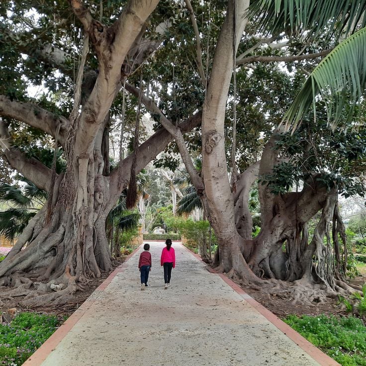
This woodland consists of native trees and orchards near Siġġiewi. The site provides habitat for birds and wildflowers and is among the few larger green spaces on Malta. The Buskett Gardens originated in the 16th century as hunting grounds for the Knights of Malta and now serve as a public park with shade trees including pines, oaks, and fruit trees. The area covers approximately 75 acres (30 hectares) and sits in a valley south of the former summer residence Verdala Palace.
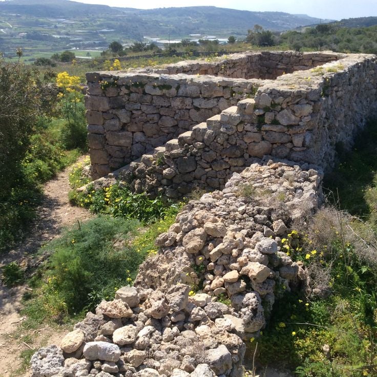
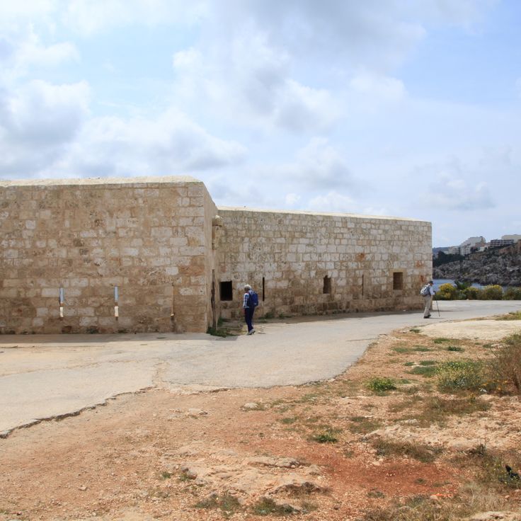
The Mistra Battery is a coastal defense structure built in 1761 on the northern coast of Malta. The stone walls of this fortification were constructed to protect Mistra Bay, which was considered a vulnerable coastal stretch during the rule of the Knights Hospitaller. The structure forms part of the extensive defense system established along the coast during the Order's governance to defend against seaborne attacks. The battery guards the approach to this coastal area and provides insight into 18th-century military architecture on Malta.
This archaeological site near the Mediterranean Sea preserves the remains of a Roman bathing complex from the second century. The excavated foundations reveal marble flooring, water channels, and heating ducts that illustrate the original thermal bathing system. The location provides insights into Roman engineering and public bathing culture in Malta during the ancient period. The complex forms part of the islands' collection of less visited archaeological remains and displays well preserved structural details of Roman bath architecture.
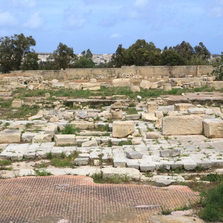
The archaeological complex of Tas-Silġ stands near Marsaxlokk and reveals building foundations from four distinct periods. Excavations document religious use spanning 4000 years, from the Neolithic era through the Bronze Age, Phoenician period, and Roman times. The remains demonstrate the cultural continuity of this sacred site across different civilizations that inhabited Malta. The grounds provide insight into the religious practices of prehistoric temple cultures as well as later Mediterranean peoples who worshipped their deities here.
This coastal watchtower from the 1600s on Marfa Ridge served the maritime defense of Malta's northwestern coast. The thick stone walls colored with red ocher and four corner turrets formed an observation post against Ottoman and North African raiders. The fortification stands as one of the isolated defensive structures that secured Malta's strategic coastal position.
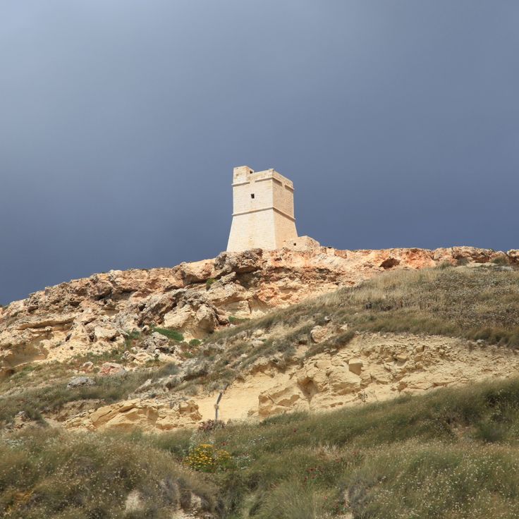
This stone tower built in 1637 stands on coastal cliffs and formed part of the Maltese defense network. The watch position provided direct views of approaching vessels from the island of Gozo and served as a strategic observation point for securing the northern coast against maritime threats.
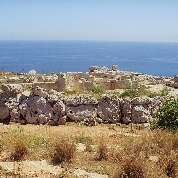
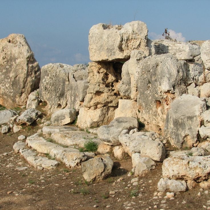
These temple ruins consist of stone structures built between 3600 and 2500 BCE with astronomical functions for observing the sun and stars. The prehistoric buildings rank among the oldest freestanding stone structures in the world and demonstrate the advanced knowledge of their builders in astronomy and architecture. The site forms part of Malta's network of prehistoric temples found across the islands.
These gardens date from the 16th century and serve as the official residence of Malta's president. The grounds cover several acres and feature water basins, sculptures, and plant collections from Mediterranean and tropical regions. Notable elements include mature trees, decorative fountains, and various garden sections with native and exotic species. The gardens are open to the public and offer walking paths through shaded avenues and maintained beds that provide insight into Malta's historical garden architecture.
The Crête de Marfa forms a 433-foot (132-meter) limestone elevation on Malta's northwestern coast, representing a geological structure of the region's sedimentary deposits. From this point, views extend across Gozo, Comino, and the surrounding Mediterranean waters. The terrain displays characteristic features of Maltese limestone formations, with terraced land and low-growing Mediterranean vegetation. This elevation stands away from tourist centers and marks the northern edge of the Marfa Peninsula, where the land drops in steep cliffs to the sea.
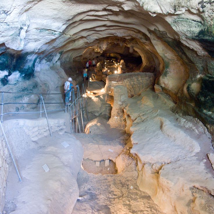
This cave near Birżebbuġa extends 472 feet (144 meters) and contains Ice Age deposits with fossils of extinct animal species. Ghar Dalam served as a refuge for dwarf elephants, hippopotami, and other fauna during the Pleistocene period, before Malta separated from the European mainland. The adjacent museum displays archaeological finds from different geological layers of the cave and documents the paleontological history of the Maltese islands.
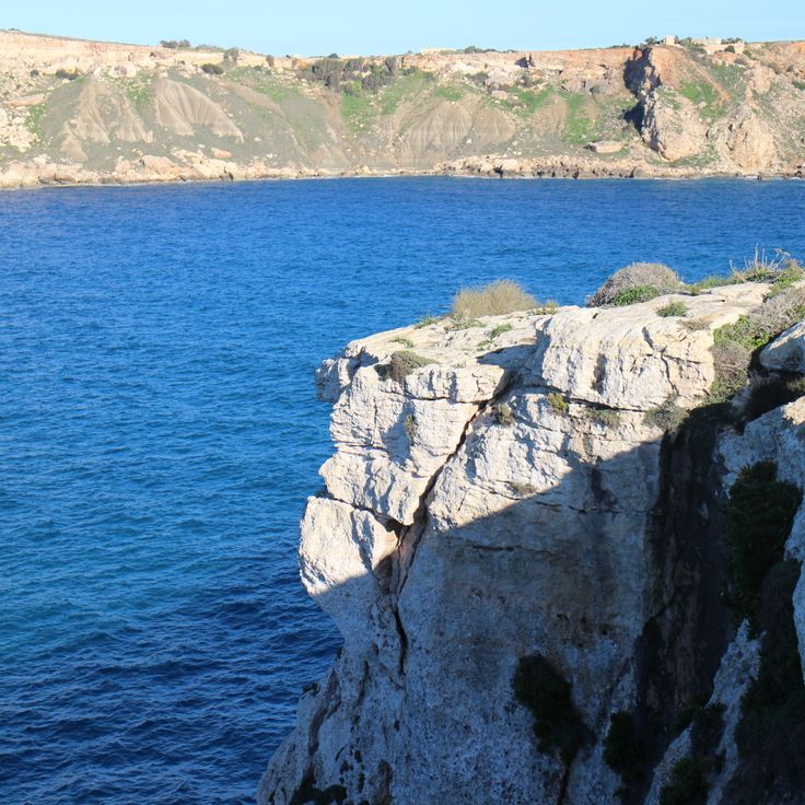
This protected area extends along 4 miles (6 kilometers) of Mediterranean coastline featuring limestone cliffs that provide views of the open sea. The region preserves World War II defense posts, traditional agricultural terraces, and stone walls documenting historical farming methods. Geological formations display limestone erosion patterns, while native flora represents Mediterranean ecosystems. Coastal paths connect the historical and natural elements of the landscape.
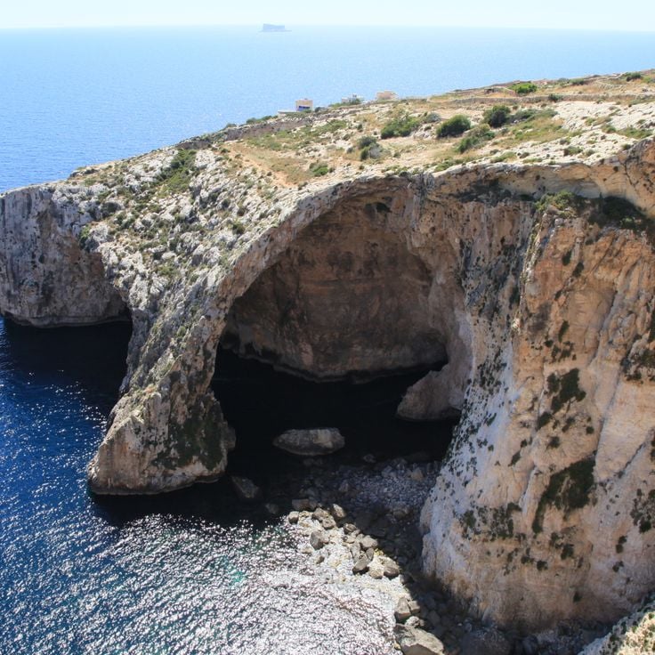
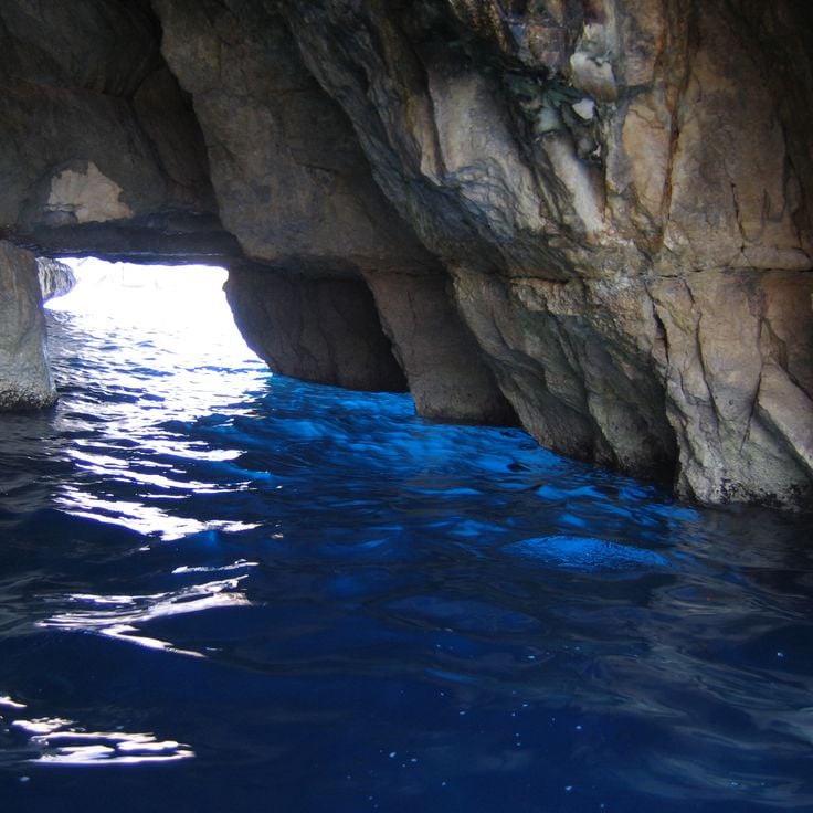
The Blue Grotto comprises a system of natural limestone caves on Malta's southern coast near Żurrieq, approximately 2 miles (3 kilometers) from the town center. These sea caverns reach heights up to 100 feet (30 meters) and have been shaped by marine currents and erosion over thousands of years. The clear Mediterranean waters reflect sunlight and create blue and green light effects on the rock walls, particularly during morning hours. This geological formation is part of Malta's remote natural sites and displays typical karst features of the island.
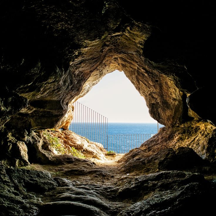
This natural cave in the cliff extends across several chambers and corridors located 230 feet (70 meters) above sea level with views over the Mediterranean. Għar Ħasan Cave belongs to the remote geological structures of Malta that lie outside the tourist zones. The cave displays the limestone formations of the island and is located near the southeastern coast, where other prehistoric sites and natural formations are found.
This underground burial complex contains 57 tombs dating from the 4th to 9th centuries, carved into limestone formations. The Ta' Bistra Catacombs are located away from tourist areas and demonstrate the development of early Christian burial practices in Malta. The burial chambers form a branching system of passages and niches that document various burial methods. This site complements the better known Roman and early Christian necropolises of the archipelago and provides insight into the religious history of the Maltese population during the Byzantine period.
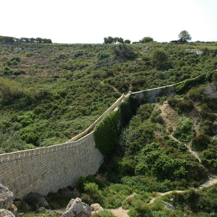
These defensive fortifications stretch 7.5 miles (12 kilometers) across Malta and were built between 1870 and 1899 by British forces. The Victoria Lines include fortification walls and watchtowers that formed a strategic barrier between the northern and southern parts of the island. Designed to protect the capital Valletta from potential invasions, the fortifications follow the natural geological fault line known as the Great Fault, using the terrain elevation for military advantage. Today the Victoria Lines serve as a historical monument and provide walking routes through the Maltese countryside.
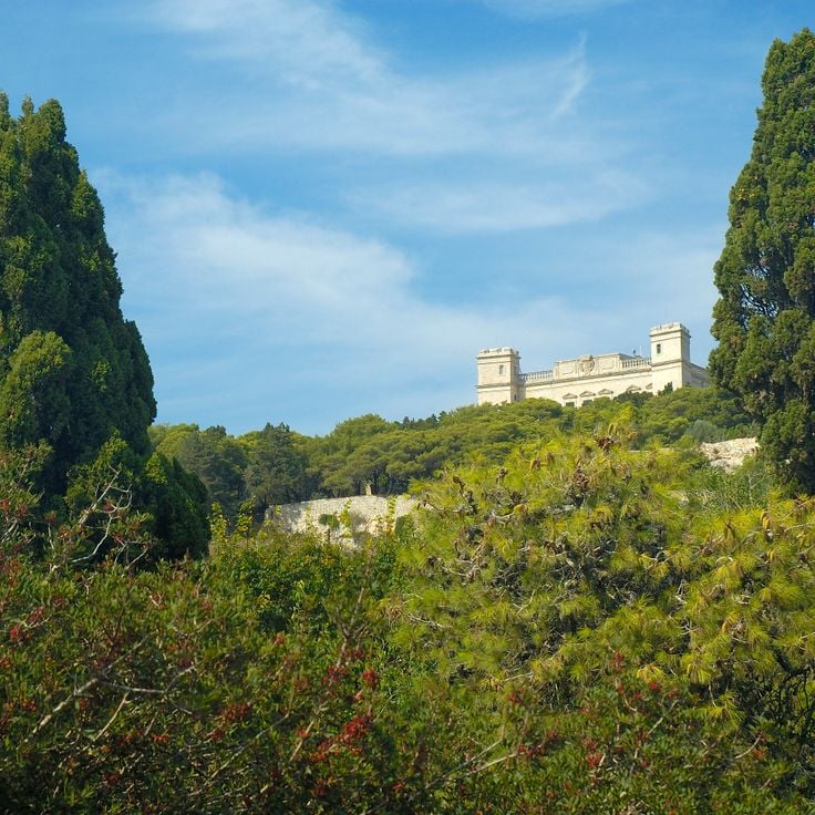
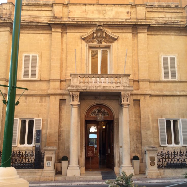
This 19th-century palace in Naxxar displays reception rooms with marble floors, mirrored walls and decorated ceilings. The surrounding gardens contain sculptures, water basins and geometrically arranged pathways. The building stands as an example of Maltese noble architecture outside urban centers and preserves elements of the original interior decoration.
Fort Binġemma is a military installation from 1878 with underground chambers and gun emplacements. The walls provide views of northern Malta and display British defense architecture from the late 19th century. This fort belongs to a series of coastal fortifications built to protect strategic points around the island.
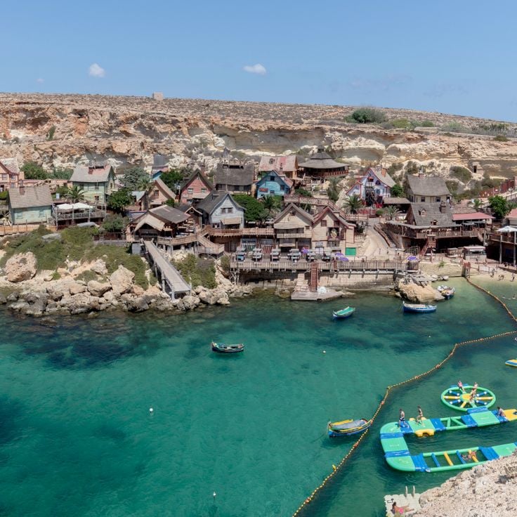
This wooden film set was built in 1979 for the production of the musical Popeye and stands near Anchor Bay. The site includes over 20 buildings styled as a harbor town, featuring residences, a post office, and a bakery. Visitors can explore the painted structures, participate in water activities, and watch live performances. The village provides insight into film production set design and is located away from Malta's main tourist areas.
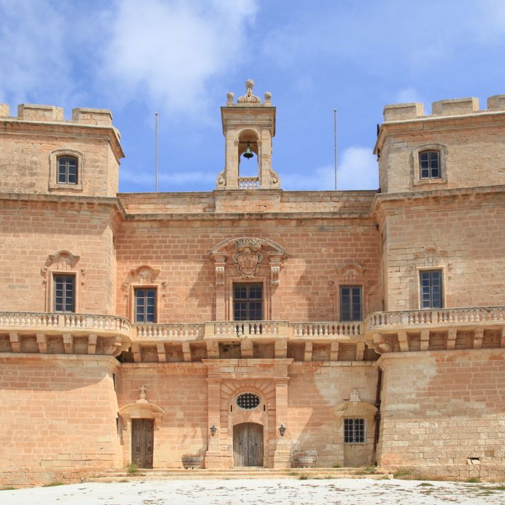
This palace was built in 1783 as a hilltop fortress featuring four towers. The structure originally served to defend the northern coastal region of Malta. From its elevated position, it provides views across the Mediterranean Sea and the nearby Saint Paul's Islands.
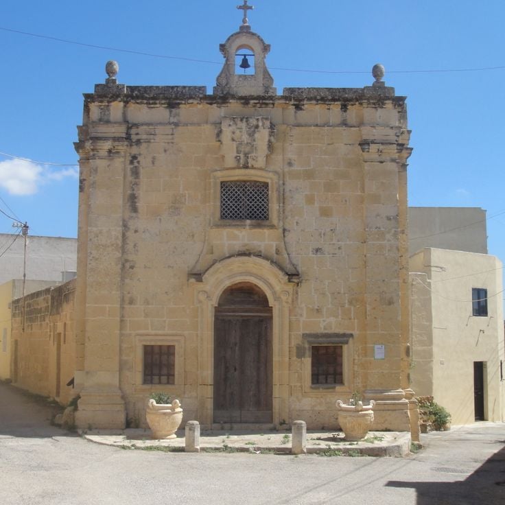
These stone chapels from the 16th and 17th centuries stand scattered across the fields surrounding Qrendi. The religious structures served local farmers as places of prayer and refuge during their work in the countryside. The simple stone buildings blend into the rural landscape and testify to the deeply rooted Catholic tradition of the Maltese population. Several of these small chapels remain standing today and offer insight into the religious practices of Malta's rural communities.
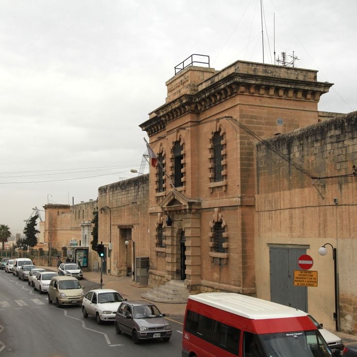
The Corradino Correctional Centre is a prison facility dating from 1850 with Victorian architecture. This structure with stone walls serves as the central prison of Malta and represents the historical development of the correctional system on the archipelago. The building combines 19th-century functional prison architecture with the characteristic construction materials of the Maltese islands.
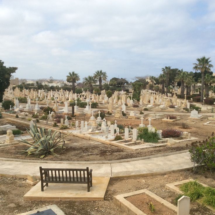
This cemetery in Kalkara contains graves of naval personnel from the British colonial period between 1800 and 1979. The burial site documents Malta's strategic role as a British naval base in the Mediterranean. The grounds provide insight into the island's military history during nearly two centuries of British presence and preserve the memory of sailors and naval officers who died during various conflicts and while serving at the station.
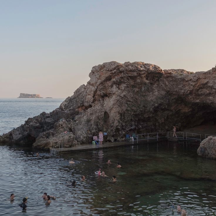
Għar Lapsi is a small natural cove with deep Mediterranean waters located in Siggiewi. This coastal formation provides divers access to underwater caves and rock structures where marine life can be observed. The remote bay is among Malta's less frequented coastal areas, situated away from tourist centers. The rocky coastline and clear waters make this location a destination for divers and snorkelers interested in exploring the region's geological formations and maritime fauna. The site represents one of Malta's natural coastal features that remains relatively undisturbed by commercial development.
This coastal fortification was built between 1715 and 1716 on the cliffs along the northern coast of Gozo to defend the island against pirate raids and enemy vessels. The battery forms part of a system of defensive structures constructed by the Knights Hospitaller during their rule over Malta. From this position, soldiers monitored the coastal waters and could detect approaching threats early. The structure displays typical features of 18th-century Maltese coastal fortifications, including gun emplacements and substantial masonry built from local limestone. Located in the rural municipality of Żebbuġ, the site provides insights into the military architecture of the Order's period.
This archaeological site preserves the foundations and floor mosaics of a Roman residential complex in Żejtun. The Villa Romaine de Żejtun documents Malta's Roman occupation through preserved structural elements and decorative floor work from antiquity. The remains provide insights into the construction methods and domestic life during the Roman period on the island.
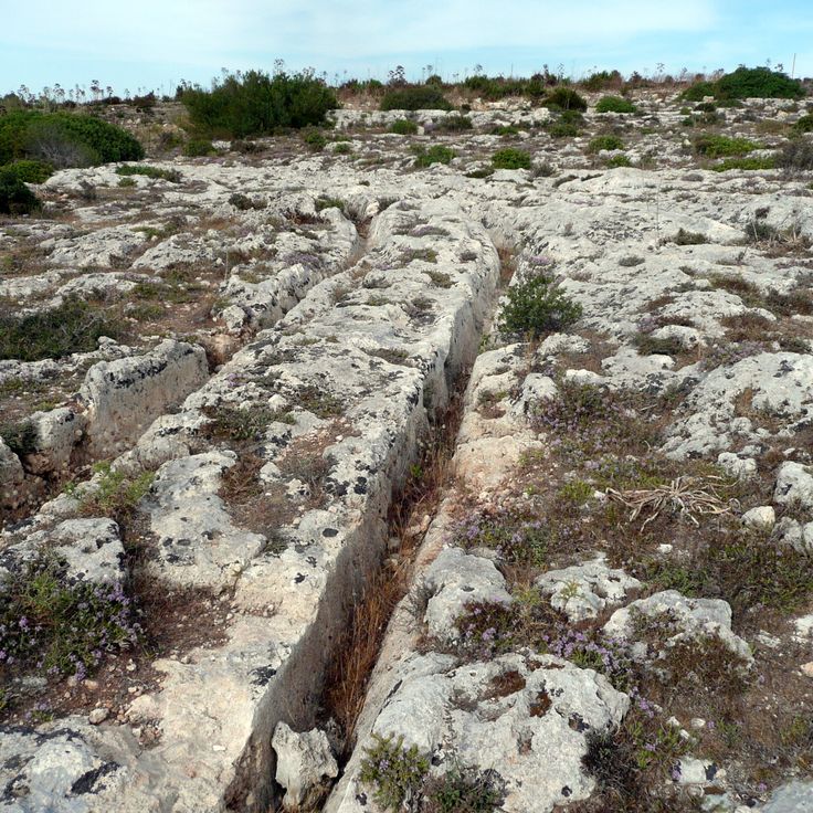
This prehistoric site displays parallel grooves carved into rock surfaces during the Bronze Age, remaining visible to this day. Misraħ Għar il-Kbir is situated away from major tourist areas and provides insights into early human activity on the island of Malta. The structures cut into the rock demonstrate the historical importance of this remote location in the southern part of the island.
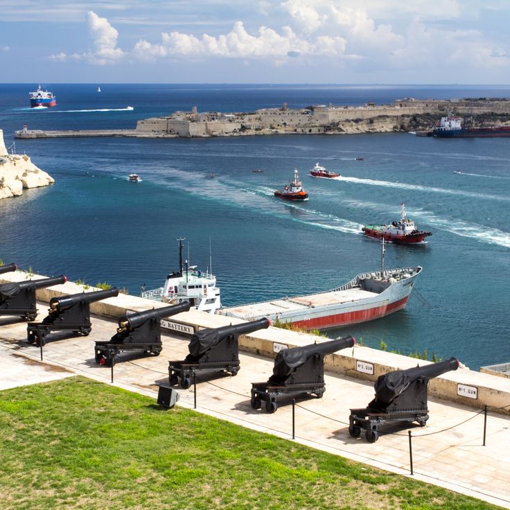
This historic defensive position in Valletta houses cannons used for maritime ceremonies. The saluting battery fires daily at noon and at 4 PM, commemorating Malta's military past as a strategic Mediterranean outpost. The installation is among the coastal defensive structures found across the Maltese islands, representing the fortification systems developed over centuries of maritime control.
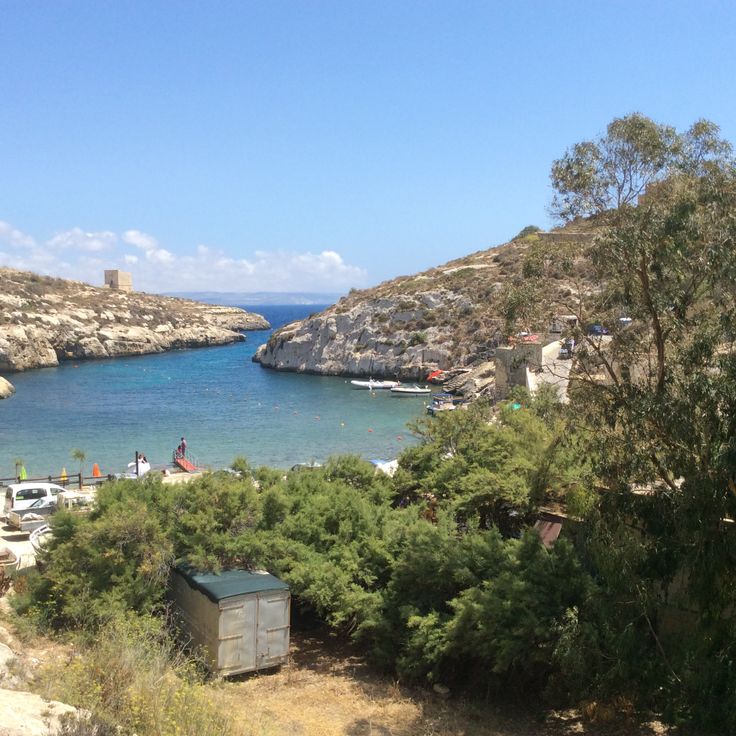
This coastal formation on Gozo is a narrow inlet surrounded by tall limestone cliffs. During the 16th century, Mgarr ix-Xini served as an anchorage for vessels of the Maltese fleet. The inlet lies away from tourist areas and provides access to the sea through a natural opening between the rocks. The geological formations display the characteristic layering of Maltese limestone.
The Skorba Temples are an archaeological site from the Neolithic period with structures dating back to 3600 BC. The excavations document early agricultural practices and represent some of the oldest settlement remains in Malta. The site encompasses several construction phases and provides insights into the prehistoric development of the island. The structures display characteristic features of Maltese temple culture and offer understanding of the Neolithic ways of life in the region.
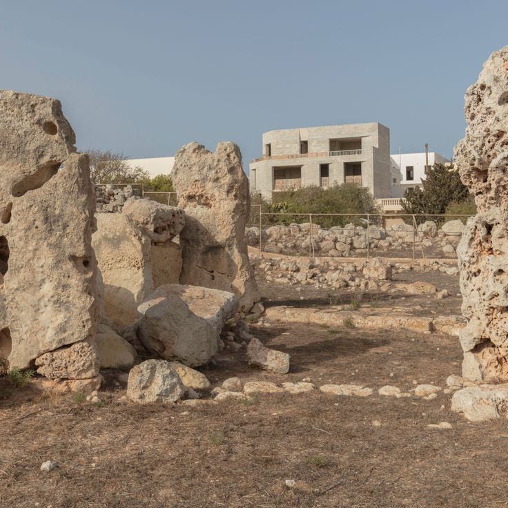
The Ta' Ħaġrat Temples form an archaeological complex of two Neolithic temples near Mġarr dating to approximately 3600 BC. The site documents the evolution of Maltese temple building through its different construction phases and techniques. The stone structures display characteristic features of Maltese megalithic culture with multiple apses and limestone blocks of varying sizes.
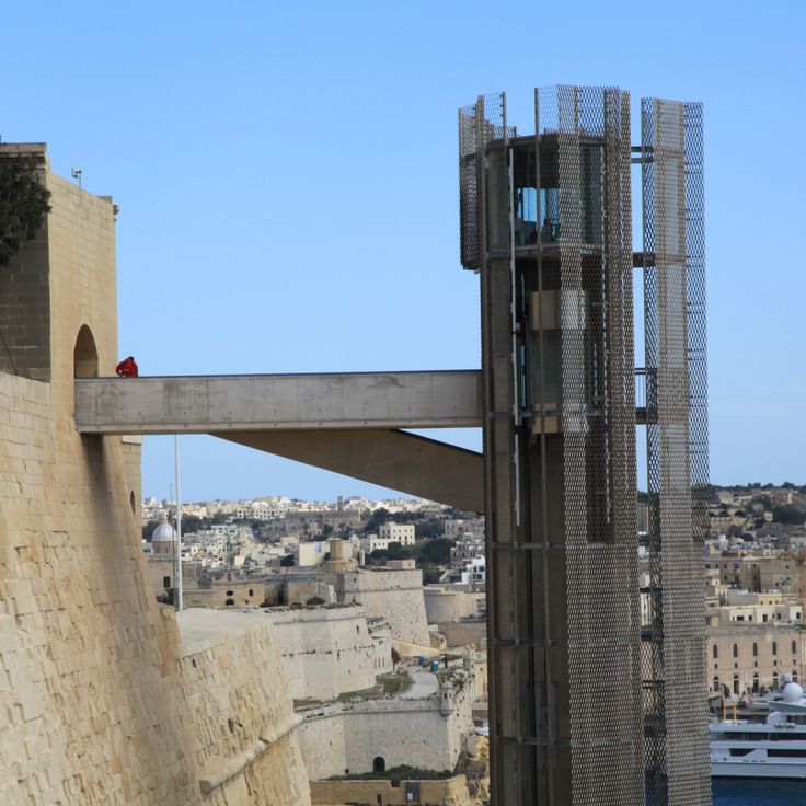
This glass and steel elevator has connected Valletta's harbor with the Upper Barrakka Gardens since 2012, covering a vertical distance of 190 feet (58 meters). The structure provides a practical alternative to the stairway routes and enables quick access between the harbor level and the upper city level. The Barrakka Lift serves as an important vertical link in the historic fortified city for both locals and visitors.
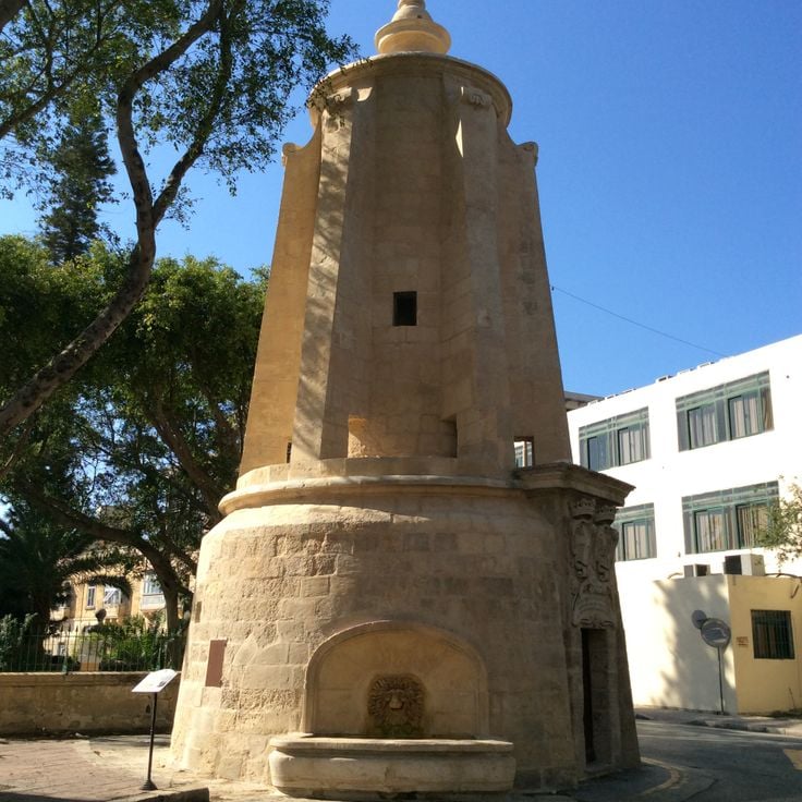
The Wignacourt Tower is a water distribution structure dating from 1615 and part of a historical aqueduct system that supplied water to the city of Valletta. This structure in Floriana represents engineering achievements from the Order's period and demonstrates 17th-century technical skill. The tower was an essential component of Malta's water infrastructure, built under Grand Master Alof de Wignacourt to provide fresh water to the growing population of the fortified capital.
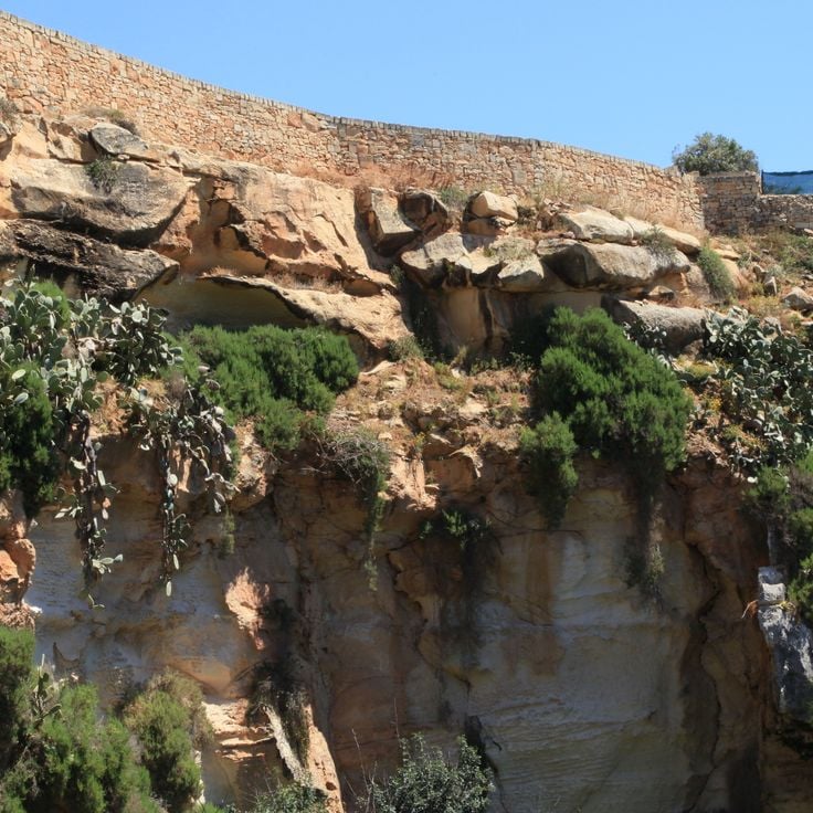
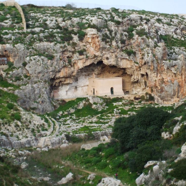
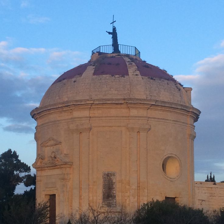
This 17th-century church was built near a geological sinkhole reaching a depth of 40 meters (131 feet). The religious structure was established as a pilgrimage site beside one of Malta's notable natural formations, created by a massive collapse of the limestone bedrock. The Maqluba depression formed a natural attraction for believers and led to the construction of this chapel at its edge. The small church connects religious tradition with the geological phenomenon and demonstrates the historical relationship between human spirituality and natural events on the island.
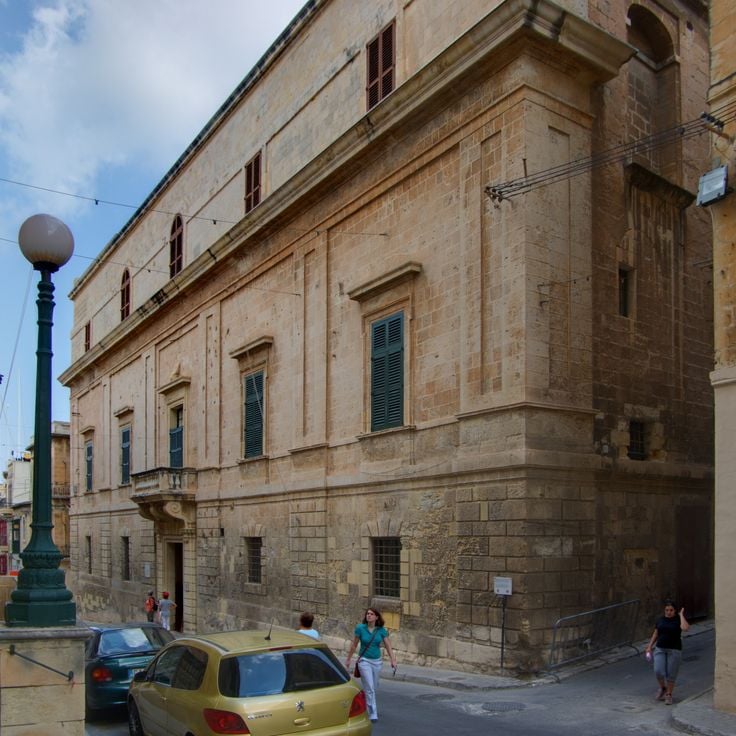
The Inquisitor's Palace in Birgu dates from 1530 and served as a court building during the rule of the Order of Malta. The structure includes courtrooms, living quarters for ecclesiastical officials, and underground cells where accused individuals were held during the Inquisition. The preserved rooms document the legal and administrative practices of this historical period. As part of the fortified city of Birgu, the palace demonstrates the institutional architecture of the 16th century and the role of the Catholic Church in Malta.
This crater reaches a depth of 98 feet (30 meters) and formed due to a ground collapse. Historical records indicate that a village occupied this site until 1343. Il-Maqluba is located in a remote area of Malta and provides an example of geological processes that shaped the island's landscape. The circular depression is surrounded by natural vegetation and represents a notable feature in the Qrendi area.
These limestone cliffs rise approximately 656 feet (200 meters) above the Mediterranean Sea and represent some of the highest coastal formations in Malta. The pebble beach at the base of the cliffs can only be reached by a steep footpath that descends through the geological layers of the island. Fomm ir-Riħ lies away from the main tourist areas and showcases the rugged northwest coastline in its natural state. The formation developed through erosion of sedimentary rock over thousands of years.
Wied il-Għasel displays remnants of Roman beekeeping with hives carved into rock. The honey production structures are preserved in the walls of this remote Maltese valley, where Roman beekeepers cut their hives directly into the natural limestone. The site documents ancient agricultural techniques and provides insights into Roman apiculture practices in Malta.
The Xemxija Trail runs for 1.2 miles (2 kilometers) to Roman beehives, Punic tombs, and ancient granaries. Information panels explain the archaeological sites along the path. This trail provides access to various historical remains from multiple periods of Maltese history, connecting Roman, Punic, and prehistoric elements at a remote location.
The Santa Marija Tal-Virtu Chapel sits on a hill near Rabat and dates from the 17th century. This chapel lies away from tourist routes and offers views over northern Malta and the Mediterranean Sea. The architecture displays typical features of Maltese church buildings from this period, with a simple exterior and religious elements inside. Its elevated position makes it a landmark in Malta's rural landscape.
This valley near Żurrieq features limestone formations and Mediterranean vegetation. Wied Babu serves as an area for climbing and hiking, displaying the characteristic geological features of Malta's southern coastal region. The rock formations resulted from erosion and form walls used by climbers, while paths through the valley provide access to the natural landscape.
This woodland consists of native trees and orchards near Siġġiewi. The site provides habitat for birds and wildflowers and is among the few larger green spaces on Malta. The Buskett Gardens originated in the 16th century as hunting grounds for the Knights of Malta and now serve as a public park with shade trees including pines, oaks, and fruit trees. The area covers approximately 75 acres (30 hectares) and sits in a valley south of the former summer residence Verdala Palace.
The Mistra Battery is a coastal defense structure built in 1761 on the northern coast of Malta. The stone walls of this fortification were constructed to protect Mistra Bay, which was considered a vulnerable coastal stretch during the rule of the Knights Hospitaller. The structure forms part of the extensive defense system established along the coast during the Order's governance to defend against seaborne attacks. The battery guards the approach to this coastal area and provides insight into 18th-century military architecture on Malta.
This archaeological site near the Mediterranean Sea preserves the remains of a Roman bathing complex from the second century. The excavated foundations reveal marble flooring, water channels, and heating ducts that illustrate the original thermal bathing system. The location provides insights into Roman engineering and public bathing culture in Malta during the ancient period. The complex forms part of the islands' collection of less visited archaeological remains and displays well preserved structural details of Roman bath architecture.
The archaeological complex of Tas-Silġ stands near Marsaxlokk and reveals building foundations from four distinct periods. Excavations document religious use spanning 4000 years, from the Neolithic era through the Bronze Age, Phoenician period, and Roman times. The remains demonstrate the cultural continuity of this sacred site across different civilizations that inhabited Malta. The grounds provide insight into the religious practices of prehistoric temple cultures as well as later Mediterranean peoples who worshipped their deities here.
This coastal watchtower from the 1600s on Marfa Ridge served the maritime defense of Malta's northwestern coast. The thick stone walls colored with red ocher and four corner turrets formed an observation post against Ottoman and North African raiders. The fortification stands as one of the isolated defensive structures that secured Malta's strategic coastal position.
This stone tower built in 1637 stands on coastal cliffs and formed part of the Maltese defense network. The watch position provided direct views of approaching vessels from the island of Gozo and served as a strategic observation point for securing the northern coast against maritime threats.
These temple ruins consist of stone structures built between 3600 and 2500 BCE with astronomical functions for observing the sun and stars. The prehistoric buildings rank among the oldest freestanding stone structures in the world and demonstrate the advanced knowledge of their builders in astronomy and architecture. The site forms part of Malta's network of prehistoric temples found across the islands.
These gardens date from the 16th century and serve as the official residence of Malta's president. The grounds cover several acres and feature water basins, sculptures, and plant collections from Mediterranean and tropical regions. Notable elements include mature trees, decorative fountains, and various garden sections with native and exotic species. The gardens are open to the public and offer walking paths through shaded avenues and maintained beds that provide insight into Malta's historical garden architecture.
The Crête de Marfa forms a 433-foot (132-meter) limestone elevation on Malta's northwestern coast, representing a geological structure of the region's sedimentary deposits. From this point, views extend across Gozo, Comino, and the surrounding Mediterranean waters. The terrain displays characteristic features of Maltese limestone formations, with terraced land and low-growing Mediterranean vegetation. This elevation stands away from tourist centers and marks the northern edge of the Marfa Peninsula, where the land drops in steep cliffs to the sea.
This cave near Birżebbuġa extends 472 feet (144 meters) and contains Ice Age deposits with fossils of extinct animal species. Ghar Dalam served as a refuge for dwarf elephants, hippopotami, and other fauna during the Pleistocene period, before Malta separated from the European mainland. The adjacent museum displays archaeological finds from different geological layers of the cave and documents the paleontological history of the Maltese islands.
This protected area extends along 4 miles (6 kilometers) of Mediterranean coastline featuring limestone cliffs that provide views of the open sea. The region preserves World War II defense posts, traditional agricultural terraces, and stone walls documenting historical farming methods. Geological formations display limestone erosion patterns, while native flora represents Mediterranean ecosystems. Coastal paths connect the historical and natural elements of the landscape.
The Blue Grotto comprises a system of natural limestone caves on Malta's southern coast near Żurrieq, approximately 2 miles (3 kilometers) from the town center. These sea caverns reach heights up to 100 feet (30 meters) and have been shaped by marine currents and erosion over thousands of years. The clear Mediterranean waters reflect sunlight and create blue and green light effects on the rock walls, particularly during morning hours. This geological formation is part of Malta's remote natural sites and displays typical karst features of the island.
This natural cave in the cliff extends across several chambers and corridors located 230 feet (70 meters) above sea level with views over the Mediterranean. Għar Ħasan Cave belongs to the remote geological structures of Malta that lie outside the tourist zones. The cave displays the limestone formations of the island and is located near the southeastern coast, where other prehistoric sites and natural formations are found.
This underground burial complex contains 57 tombs dating from the 4th to 9th centuries, carved into limestone formations. The Ta' Bistra Catacombs are located away from tourist areas and demonstrate the development of early Christian burial practices in Malta. The burial chambers form a branching system of passages and niches that document various burial methods. This site complements the better known Roman and early Christian necropolises of the archipelago and provides insight into the religious history of the Maltese population during the Byzantine period.
These defensive fortifications stretch 7.5 miles (12 kilometers) across Malta and were built between 1870 and 1899 by British forces. The Victoria Lines include fortification walls and watchtowers that formed a strategic barrier between the northern and southern parts of the island. Designed to protect the capital Valletta from potential invasions, the fortifications follow the natural geological fault line known as the Great Fault, using the terrain elevation for military advantage. Today the Victoria Lines serve as a historical monument and provide walking routes through the Maltese countryside.
This 19th-century palace in Naxxar displays reception rooms with marble floors, mirrored walls and decorated ceilings. The surrounding gardens contain sculptures, water basins and geometrically arranged pathways. The building stands as an example of Maltese noble architecture outside urban centers and preserves elements of the original interior decoration.
Fort Binġemma is a military installation from 1878 with underground chambers and gun emplacements. The walls provide views of northern Malta and display British defense architecture from the late 19th century. This fort belongs to a series of coastal fortifications built to protect strategic points around the island.
This wooden film set was built in 1979 for the production of the musical Popeye and stands near Anchor Bay. The site includes over 20 buildings styled as a harbor town, featuring residences, a post office, and a bakery. Visitors can explore the painted structures, participate in water activities, and watch live performances. The village provides insight into film production set design and is located away from Malta's main tourist areas.
This palace was built in 1783 as a hilltop fortress featuring four towers. The structure originally served to defend the northern coastal region of Malta. From its elevated position, it provides views across the Mediterranean Sea and the nearby Saint Paul's Islands.
These stone chapels from the 16th and 17th centuries stand scattered across the fields surrounding Qrendi. The religious structures served local farmers as places of prayer and refuge during their work in the countryside. The simple stone buildings blend into the rural landscape and testify to the deeply rooted Catholic tradition of the Maltese population. Several of these small chapels remain standing today and offer insight into the religious practices of Malta's rural communities.
The Corradino Correctional Centre is a prison facility dating from 1850 with Victorian architecture. This structure with stone walls serves as the central prison of Malta and represents the historical development of the correctional system on the archipelago. The building combines 19th-century functional prison architecture with the characteristic construction materials of the Maltese islands.
This cemetery in Kalkara contains graves of naval personnel from the British colonial period between 1800 and 1979. The burial site documents Malta's strategic role as a British naval base in the Mediterranean. The grounds provide insight into the island's military history during nearly two centuries of British presence and preserve the memory of sailors and naval officers who died during various conflicts and while serving at the station.
Għar Lapsi is a small natural cove with deep Mediterranean waters located in Siggiewi. This coastal formation provides divers access to underwater caves and rock structures where marine life can be observed. The remote bay is among Malta's less frequented coastal areas, situated away from tourist centers. The rocky coastline and clear waters make this location a destination for divers and snorkelers interested in exploring the region's geological formations and maritime fauna. The site represents one of Malta's natural coastal features that remains relatively undisturbed by commercial development.
This coastal fortification was built between 1715 and 1716 on the cliffs along the northern coast of Gozo to defend the island against pirate raids and enemy vessels. The battery forms part of a system of defensive structures constructed by the Knights Hospitaller during their rule over Malta. From this position, soldiers monitored the coastal waters and could detect approaching threats early. The structure displays typical features of 18th-century Maltese coastal fortifications, including gun emplacements and substantial masonry built from local limestone. Located in the rural municipality of Żebbuġ, the site provides insights into the military architecture of the Order's period.
This archaeological site preserves the foundations and floor mosaics of a Roman residential complex in Żejtun. The Villa Romaine de Żejtun documents Malta's Roman occupation through preserved structural elements and decorative floor work from antiquity. The remains provide insights into the construction methods and domestic life during the Roman period on the island.
This prehistoric site displays parallel grooves carved into rock surfaces during the Bronze Age, remaining visible to this day. Misraħ Għar il-Kbir is situated away from major tourist areas and provides insights into early human activity on the island of Malta. The structures cut into the rock demonstrate the historical importance of this remote location in the southern part of the island.
This historic defensive position in Valletta houses cannons used for maritime ceremonies. The saluting battery fires daily at noon and at 4 PM, commemorating Malta's military past as a strategic Mediterranean outpost. The installation is among the coastal defensive structures found across the Maltese islands, representing the fortification systems developed over centuries of maritime control.
This coastal formation on Gozo is a narrow inlet surrounded by tall limestone cliffs. During the 16th century, Mgarr ix-Xini served as an anchorage for vessels of the Maltese fleet. The inlet lies away from tourist areas and provides access to the sea through a natural opening between the rocks. The geological formations display the characteristic layering of Maltese limestone.
The Skorba Temples are an archaeological site from the Neolithic period with structures dating back to 3600 BC. The excavations document early agricultural practices and represent some of the oldest settlement remains in Malta. The site encompasses several construction phases and provides insights into the prehistoric development of the island. The structures display characteristic features of Maltese temple culture and offer understanding of the Neolithic ways of life in the region.
The Ta' Ħaġrat Temples form an archaeological complex of two Neolithic temples near Mġarr dating to approximately 3600 BC. The site documents the evolution of Maltese temple building through its different construction phases and techniques. The stone structures display characteristic features of Maltese megalithic culture with multiple apses and limestone blocks of varying sizes.
This glass and steel elevator has connected Valletta's harbor with the Upper Barrakka Gardens since 2012, covering a vertical distance of 190 feet (58 meters). The structure provides a practical alternative to the stairway routes and enables quick access between the harbor level and the upper city level. The Barrakka Lift serves as an important vertical link in the historic fortified city for both locals and visitors.
The Wignacourt Tower is a water distribution structure dating from 1615 and part of a historical aqueduct system that supplied water to the city of Valletta. This structure in Floriana represents engineering achievements from the Order's period and demonstrates 17th-century technical skill. The tower was an essential component of Malta's water infrastructure, built under Grand Master Alof de Wignacourt to provide fresh water to the growing population of the fortified capital.
This 17th-century church was built near a geological sinkhole reaching a depth of 40 meters (131 feet). The religious structure was established as a pilgrimage site beside one of Malta's notable natural formations, created by a massive collapse of the limestone bedrock. The Maqluba depression formed a natural attraction for believers and led to the construction of this chapel at its edge. The small church connects religious tradition with the geological phenomenon and demonstrates the historical relationship between human spirituality and natural events on the island.
The Inquisitor's Palace in Birgu dates from 1530 and served as a court building during the rule of the Order of Malta. The structure includes courtrooms, living quarters for ecclesiastical officials, and underground cells where accused individuals were held during the Inquisition. The preserved rooms document the legal and administrative practices of this historical period. As part of the fortified city of Birgu, the palace demonstrates the institutional architecture of the 16th century and the role of the Catholic Church in Malta.