See the monuments around you in AROpen chests in the app
Around Us is built for your phone — point your camera at the streets and discover the monuments and places around you in augmented reality.Around Us is built for your phone — chests unlock when you walk, explore and capture nearby places.
Photo locations in Quebec: Montmorency Falls, Old Quebec, Château Frontenac
Quebec provides varied photographic settings across a province that combines French colonial heritage with extensive natural landscapes. In Quebec City, the stone buildings of Old Quebec, Fairmont Le Château Frontenac, and Montmorency Falls with its 83-meter drop form key subjects. The historic Quartier Petit Champlain, Frontenac Staircase, and Grande-Allée display the city's European-influenced architecture, while the Plains of Abraham and Observatoire de la Capitale offer vantage points.
Montreal presents different photographic opportunities with Notre-Dame Basilica, Saint Joseph's Oratory on Mount Royal, and contemporary facilities like the Biosphère and Grande Roue. Lachine Canal and street art along Boulevard Saint-Laurent add to urban captures. The Gaspé Peninsula, Jacques-Cartier National Park, Laurentides Wildlife Reserve, and locations like Île d'Orléans and Mont-Tremblant show the province's natural terrain. The Saint Lawrence River connects many of these sites as the primary waterway, from its lower reaches near Rimouski to the riverbanks at Montreal and Quebec City.
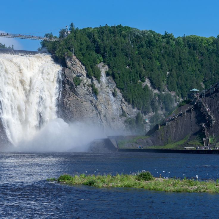
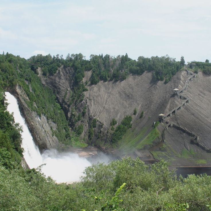
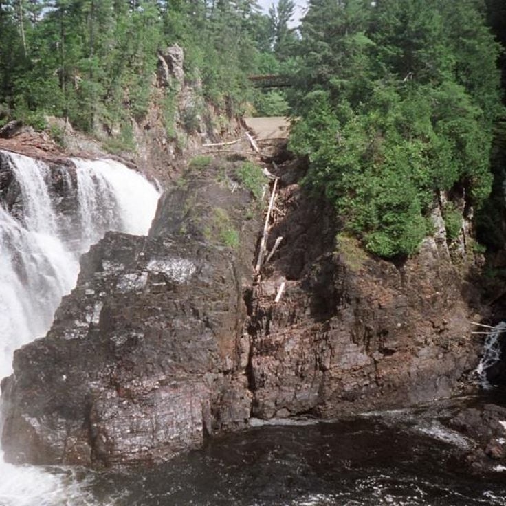
This 83-meter (270-foot) waterfall provides year-round photography subjects, from summer cascades to frozen ice formations in winter. Montmorency Falls sits a few miles northeast of Quebec City along the Saint Lawrence River and ranks among the province's notable natural sites. A suspension bridge at the top allows photographers to capture different perspectives, while staircases and a cable car system provide access to viewpoints at the base and summit. The falls drop over a cliff into the Montmorency River, creating constant spray that offers photographic opportunities under certain light conditions.
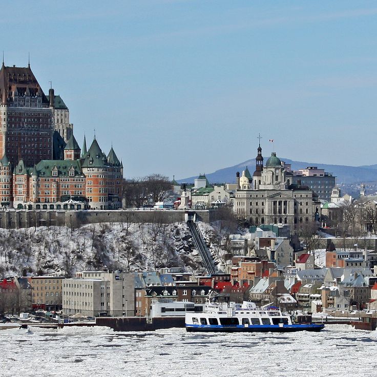
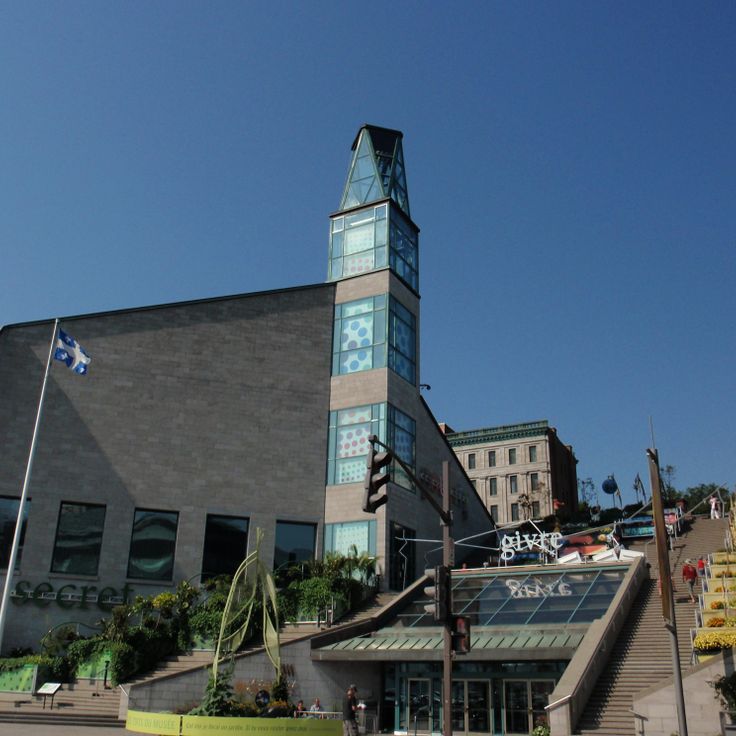
This UNESCO World Heritage site represents Quebec's French colonial architecture and forms a central location within the province's photography settings. Old Quebec displays 17th and 18th century buildings, including merchant houses with stone facades, the Citadel and preserved fortifications. The cobblestone streets run through neighborhoods where limestone structures document religious and administrative functions from the colonial period. This district provides subjects ranging from defensive walls to narrow lanes lined with historical facades, complementing the natural landmarks and urban locations that define photography opportunities across Quebec.
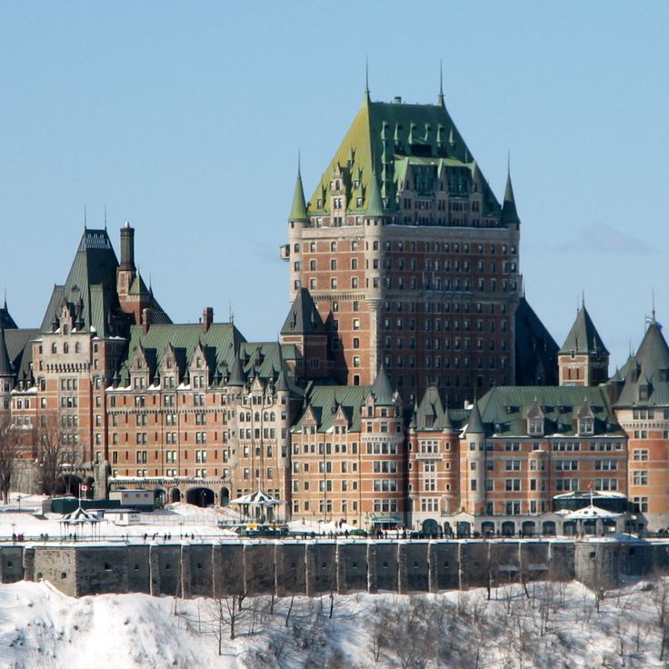
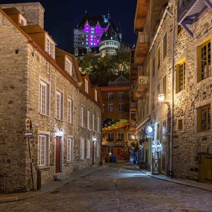
This luxury hotel, built in 1893 in French castle style, stands on Dufferin Terrace and offers views over the Saint Lawrence River. Fairmont Le Château Frontenac defines the skyline of Upper Town Quebec and ranks among Canada's most photographed structures. The building's towers and copper roofs combine European architectural elements with Canadian history, documenting the city's development as a trading and administrative center. For photographers, the hotel provides numerous perspectives, from the riverside promenade to the surrounding streets of the Old Town, capturing both its exterior grandeur and its place within the historic district.
This park north of Old Quebec contains an 83-meter waterfall on the Saint Lawrence River and provides multiple vantage points for photography. A cable car connects the lower and upper levels, and walking trails lead through the forested area surrounding Chute-Montmorency. The grounds include several platforms, among them a suspension bridge at the top of the falls that offers views of the river and surrounding landscape. The park operates year-round and winter months transform the falls into an ice sculpture, while spring and fall provide different lighting conditions for shooting.
This 98-hectare (240-acre) park occupies a plateau above the St. Lawrence River and was the site of a decisive 1759 battle between British and French forces. The Plains of Abraham now serve as Quebec City's central green space, hosting the National Museum of Fine Arts of Quebec along with regular concerts, sports events and cultural activities. The grounds include walking paths, open lawns and historical monuments that mark key moments from the battle. The park connects to the wider Battlefields Park system and provides views across the river valley.
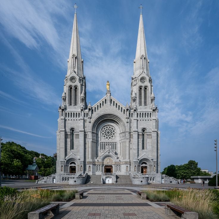
This neo-Romanesque church was built in 1926 and serves as a major pilgrimage site along the Saint Lawrence River. The Basilica of Sainte-Anne-de-Beaupré features religious scenes rendered in stained glass windows and mosaics, offering photographers opportunities to capture liturgical art and architectural details. The interior extends 328 feet (100 meters) in length and provides multiple perspectives for architectural photography. As part of Quebec's photo locations, this basilica complements the province's documentation of religious structures alongside its historic buildings and natural landmarks.
This island in the Saint Lawrence River comprises six historical villages connected by a 42-mile (67-kilometer) ring road. Île d'Orléans preserves French Canadian architecture from the 18th and 19th centuries, including stone churches, farmhouses, and manor homes. The agricultural tradition shows through orchards, vineyards, and family operations producing cider, maple products, and cheese. Photographers find rural landscapes along the river, traditional buildings, and seasonal harvest fields that characterize Quebec as a photography destination.
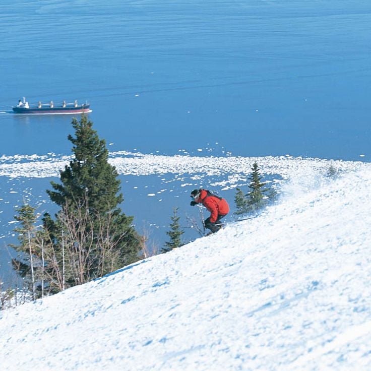
Le Massif de Charlevoix extends across 770 meters (2,526 feet) of vertical drop and provides views of the Saint Lawrence River. The ski resort contains 53 runs used for downhill skiing in winter, while trails serve hikers during summer months. The combination of alpine terrain and river proximity creates subjects that showcase both mountain sports and maritime elements within Quebec's Charlevoix region. This resort serves as a location for capturing winter activities against the river backdrop or for landscape photography documenting the geographic particularity of these coastal mountains.
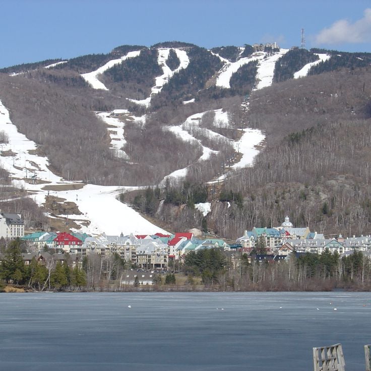
Mont-Tremblant is a winter sports area in the Laurentian Mountains with 96 ski trails across varying difficulty levels. The gondola reaches the 875-meter (2,871-foot) summit, providing views of the surrounding mountain terrain. The village at the base follows a French Alpine architectural style, housing restaurants, shops and lodging. This location offers photography subjects including ski slopes, mountain landscapes and the uniform village architecture. During summer, the trails convert to hiking paths while Lac Tremblant adds water-based compositions. Mont-Tremblant ranks among the notable photography sites in Quebec, combining athletic activities with mountainous natural settings and deliberate architectural planning.
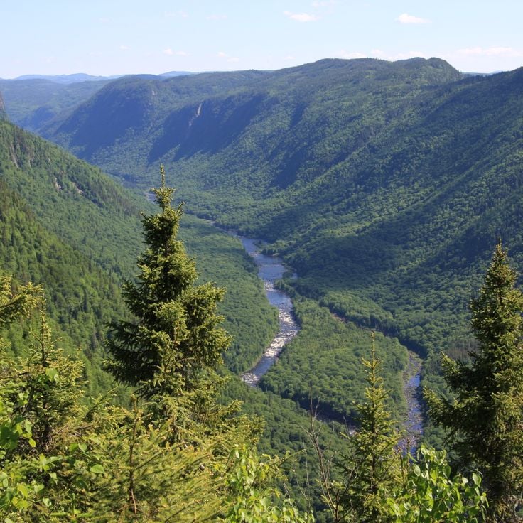
This 550-square-mile (1,400-square-kilometer) national park protects the deep valleys and river systems of the Jacques-Cartier River, about 25 miles (40 kilometers) north of Quebec City. The reserve provides habitat for moose and white-tailed deer that inhabit the forested slopes and river valleys. The park contains several hiking trails that access the cliffs and viewpoints along the river. The landscape works for nature photography of the Laurentian Mountains and the river bends that wind through the valley. In winter, the area transforms into a destination for snowshoeing and cross-country skiing.
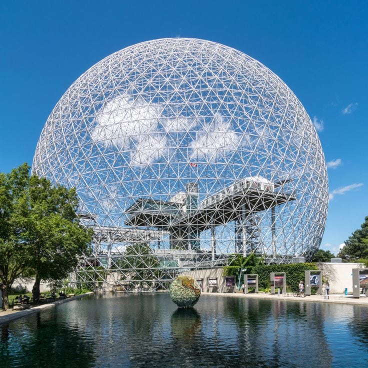
This geodesic structure on Île Sainte-Hélène was originally designed as the United States pavilion for Expo 67 and later converted into an environmental museum. The Biosphère now houses exhibits on water systems, climate change and sustainable development in the Saint Lawrence River ecosystem. The 200-foot steel and acrylic structure offers photographers geometric patterns and reflections against Montreal's skyline. Its island location in the river allows for shots of the dome with urban backdrop or natural riverbank vegetation. The structure serves as an architectural example of mid-century design and as a working educational center for environmental topics in Quebec.
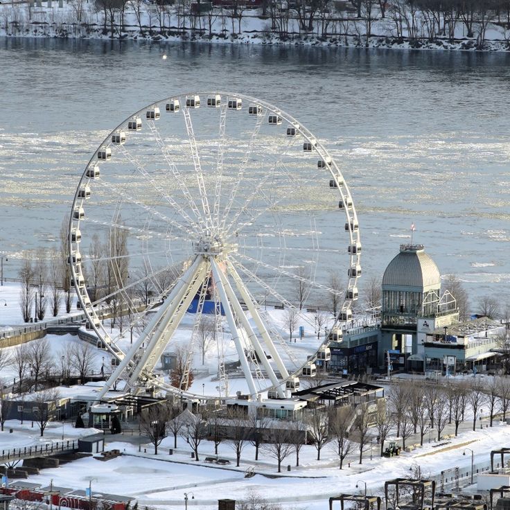
La Grande Roue de Montréal stands in the Old Port and serves as a modern landmark in the city. The climate-controlled cabins rise to 200 feet (61 meters) and offer views across the Saint Lawrence River, Old Montreal and the surrounding boroughs. Opened in 2017, this observation wheel operates year-round, allowing visitors to photograph the city from an elevated vantage point in any season. The wheel occupies a central position along the waterfront and provides a base for capturing urban panoramas and river landscapes.
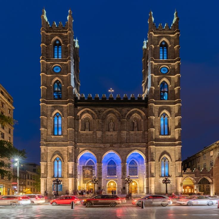
This basilica ranks among the most significant examples of Gothic Revival architecture in Quebec. Completed in 1829, the church presents an interior featuring carved wood elements created by craftsmen from Quebec and Europe. The stained glass windows depict scenes from Montreal's history rather than traditional biblical narratives. The altar received gold leaf treatment, while the blue ceiling displays golden stars. The church offers photographic subjects ranging from architectural details to liturgical objects and the interplay of natural and artificial light through the colored windows.
The Quartier Petit Champlain sits at the base of the cliff below the Château Frontenac, forming one of the oldest commercial districts in North America. This pedestrian zone spans several short cobblestone streets lined with two and three story buildings from the 17th and 18th centuries, now housing local boutiques, art galleries and restaurants. Multiple building facades display large scale murals depicting historical scenes from the city's past. The main thoroughfare, Rue du Petit-Champlain, connects the lower harbor area to the Breakneck Steps stairway that climbs to the upper town. This quarter documents French colonial architecture and provides photographic compositions with the steep rock face of Cap Diamant rising behind the streetscapes.
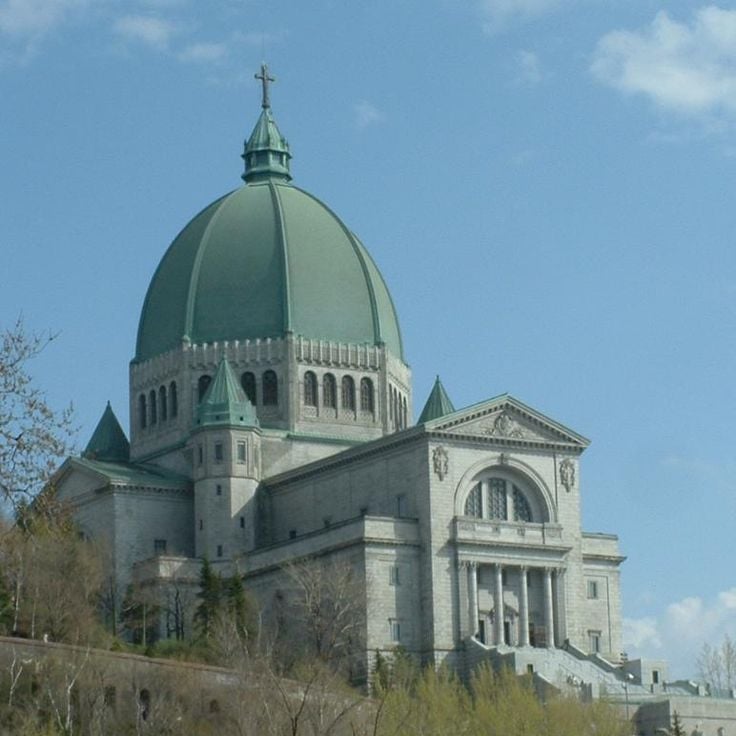
Saint Joseph's Oratory sits on the western slope of Mount Royal overlooking Montreal. Completed in 1967, this Roman Catholic minor basilica features a copper dome that rises 320 feet (97 meters) and ranks among the largest of its kind in the world. The site encompasses multiple levels with gardens, chapels and observation points that provide views across the city and surrounding mountain ranges. The complex attracts about two million visitors each year and serves as an important pilgrimage destination. Interior spaces display stained glass windows, mosaics and a crypt housing the tomb of Brother André, the founder. The elevated position on Mount Royal allows photographers to capture both architectural details of the dome and wide perspectives that frame the oratory within its urban context.
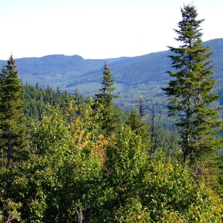
This protected area spans 7,861 square kilometers (3,036 square miles) in northern Quebec, providing photographers with access to boreal forests, more than 2,000 lakes, and diverse wildlife. The Laurentides Wildlife Reserve supports populations of moose, deer, and beaver within its natural habitat. The extensive coniferous forests and waterways create opportunities for wildlife and landscape photography. The reserve operates as a controlled recreation area with designated zones for animal observation.
This market spans several city blocks in the Little Italy neighborhood and has operated since 1933, offering regional products from Quebec farmers and vendors. Jean-Talon Market contains more than 150 stalls selling fruits, vegetables, cheeses, meats, baked goods and maple products that reflect the province's agricultural output. The 1930s architecture features covered walkways and open-air sections that provide photographic subjects including product displays, vendor-customer interactions and seasonal produce arrangements. As Montreal's largest public market, this location demonstrates Quebec's food traditions within a working commercial environment that serves both residents and visitors throughout the year.
The Morrin Centre was originally a Victorian prison that operated between 1808 and 1867. The building now houses an English-language library, a cultural center and a small museum documenting the history of Quebec's anglophone community. The former prison cells in the basement are accessible during guided tours and show the detention conditions of the 19th century. The library on the first floor contains historical collections and serves as a gathering place for cultural events. As a photography location in Quebec, the Morrin Centre offers a connection between Victorian architecture and institutional history in Old Quebec City.
This canyon near Beaupré cuts 74 meters (240 feet) into the bedrock, forming a gorge that displays the erosive power of water over geological time. Three fixed suspension bridges cross at different elevations, providing views of the waterfall that flows through the gorge. Paved pathways follow the canyon rim and descend partway into the chasm, while two zip lines span the width of the gorge above the water. The site demonstrates how the Sainte-Anne River has carved through Precambrian rock formations common to this part of Quebec.
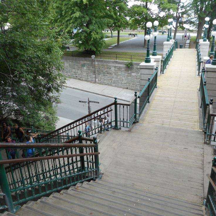
This historic stone staircase connects the Upper Town with the Lower Town in Quebec City, bridging several elevation levels between the Château Frontenac and the harbor district. The Frontenac Staircase comprises 59 steps flanked by flower beds, providing a direct pedestrian route through the fortified old town. The staircase serves as both a practical link between the two levels and a vantage point overlooking the Saint Lawrence River. Photographers find angles here capturing the French colonial architecture, stone fortifications, and layered structure of the historic city, particularly during early morning hours or at dusk.
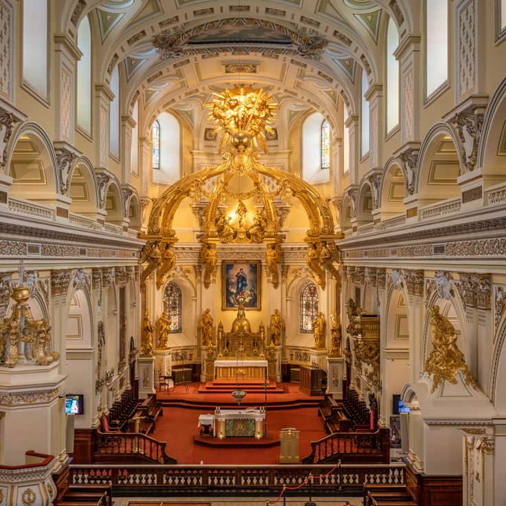
This cathedral basilica dates from the 17th century and displays French architecture with stained glass windows and a gold decorated ceiling. The interior contains religious artworks and offers photographers opportunities to capture details of colonial ecclesiastical architecture typical of Quebec City's historic district. The basilica serves as an example of French church tradition in North America and allows shots of liturgical elements and architectural details that document European influence on the province's religious building practices.
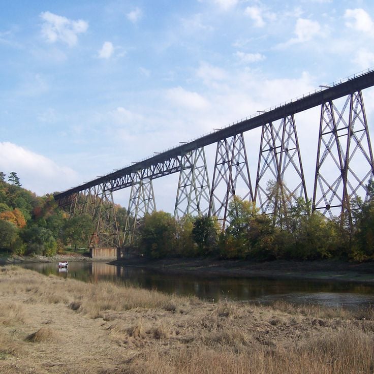
This railway bridge with its distinctive metal structure crosses the Cap-Rouge River at a height of 164 feet (50 meters) and has connected both banks since 1908. The Tracel Bridge stands among the historic infrastructure works in the Quebec region and offers photographers opportunities to capture industrial architecture alongside the natural river landscape. The structure displays typical early twentieth-century engineering elements and fits within the range of photography locations that span from the stone architecture of Old Quebec to natural landmarks such as Montmorency Falls.
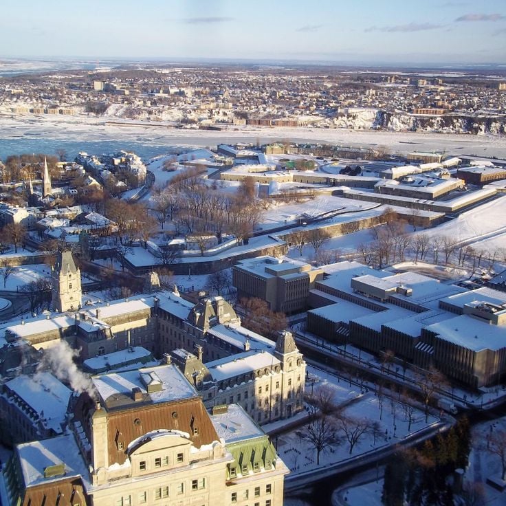
The Observatoire de la Capitale offers the highest public viewpoint in Quebec City. This observation deck on the 31st floor of the Marie-Guyart Building provides a 360-degree view over Old Quebec, the Saint Lawrence River, and the surrounding Laurentian Mountains. At 721 feet (221 meters) above sea level, the platform allows photographers to capture the entire city layout, including its historic quarters and modern districts. Floor-to-ceiling windows enable unobstructed shooting in all directions. This vantage point documents the city's geography at the confluence of the Saint Lawrence and Saint Charles rivers, as well as the extent of urban development spreading across both riverbanks.
This modern museum in Québec City presents interactive exhibitions on human history and regional traditions. The collections include archaeological findings, ethnographic objects and historical artifacts documenting the development of society in Québec. Visitors explore galleries on Indigenous cultures, French colonial history and contemporary life in the province. Rotating special exhibitions complement the permanent displays with themes from anthropology, social history and everyday culture.
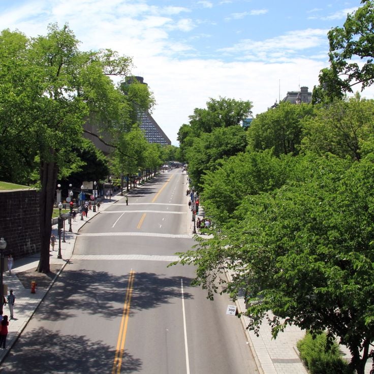
This main street connects the Parliament Building to the Plains of Abraham and runs through one of the city's busiest districts. Grande-Allée contains 19th-century mansions that now house restaurants, bars and boutiques. The wide avenue offers clear sightlines to architectural details along its length. Photographers find subjects ranging from Victorian architecture to contemporary urban life here. The street serves as a transition between government districts and the historic battlefields, with each section presenting different visual elements.
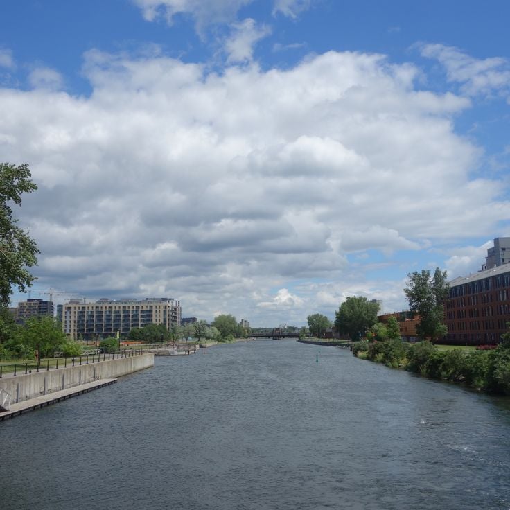
The Lachine Canal runs for 14.5 kilometers, linking the Saint Lawrence River to Montreal's harbor through a series of locks. Built in the 19th century for commercial shipping, the waterway was later decommissioned and reopened in the 1990s as a public recreation corridor. Former industrial buildings in brick and stone line the banks, now converted to residences, offices and galleries. Paved cycling and walking paths run along both sides of the canal, offering access to green spaces and resting areas. The five lock systems remain operational, allowing boat traffic during summer months. Anglers, kayakers and cyclists use the canal regularly, and several bridges cross the waterway, connecting adjacent Montreal neighborhoods.
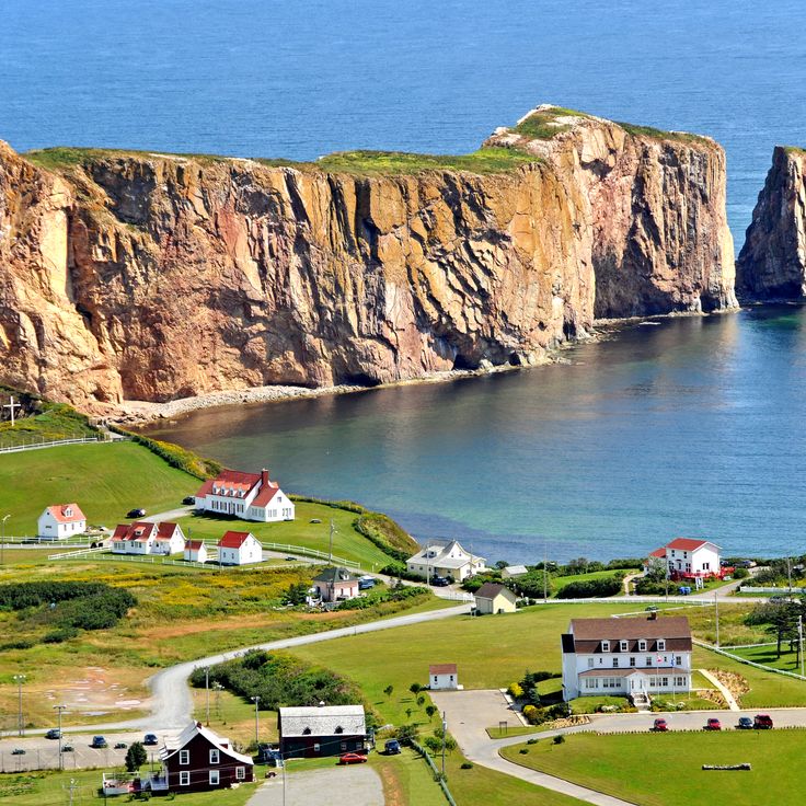
This peninsula extends 200 kilometers (125 miles) along the Saint Lawrence River and provides photographers with access to cliffs, lighthouses and fishing villages. The area includes Forillon National Park with its coastal formations and Percé Rock, which rises 88 meters (290 feet) above the water. The region displays maritime architecture in communities like Percé and Gaspé, while the coastline alternates between rocky shores and sand beaches. Fog and changing light conditions from the river's influence create varied conditions for coastal and architectural photography in this collection of Quebec locations.
This nature park on the Gaspésie coast presents Canadian wildlife in naturalistic enclosures and offers a network of paths through forested terrain. Bioparc de la Gaspésie displays native species including black bears, beavers and lynx in habitats that replicate their natural environments. Visitors can explore different ecosystems along the woodland trails, while interactive stations provide information about regional fauna. The facility serves both wildlife observation and environmental education, allowing close-range photography of animals in controlled outdoor settings that mimic Quebec's natural landscapes.
This boulevard displays murals and graffiti art by artists from Montreal and around the world along several kilometers of wall space. Boulevard Saint-Laurent serves as an urban photography subject in Quebec's largest city, where street art spans different styles and techniques. The artworks change regularly through new additions and reflect contemporary cultural themes. Photographers find examples of urban art here that contrast with Quebec's historical architectural elements and document the city's modern artistic development. The street provides accessible vantage points for capturing large-scale public art within the metropolitan environment.
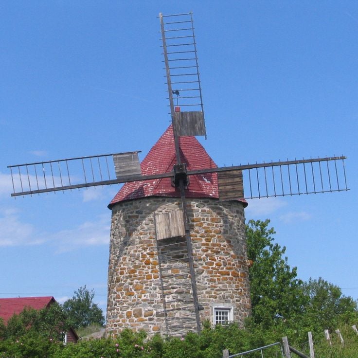
This island in the Saint Lawrence River provides multiple subjects documenting Quebec's rural heritage within a compact setting. Île aux Coudres contains two historic windmills dating from the 18th century, preserved as working examples of traditional grain processing. A 14-mile (23-kilometer) cycling path circles the island, providing access to agricultural landscapes and villages with 19th-century houses. Apple orchards cover portions of the island, creating structured compositions during bloom and harvest periods. The river setting produces perspectives with water in the foreground and the Charlevoix mountains as backdrop. Fishing houses and barns along the coastal road display elements of maritime architecture in wood construction.
The Parc National des Hautes-Gorges-de-la-Rivière-Malbaie documents the landscape formations of the Charlevoix region through its 800-meter (2,600-foot) rock walls rising along the Rivière Malbaie. This national park offers photographers subjects ranging from steep cliff faces to forested slopes and the river system that cuts through the gorge. The hiking trail network leads to overlooks where the proportions of the gorge and geological structures become visible. Kayaking on the river provides water-level perspectives, while vegetation shifts with seasons to deliver different color palettes for landscape photography.
Le Parc des Chutes Coulonge presents several waterfalls along a nature trail in an area once shaped by the logging industry. The park combines Quebec's natural landscapes with recreational activities including tree climbing and zip lines. The waterfalls and forested sections provide photographic subjects that capture both flowing water and the province's dense woodlands. The site documents the region's industrial past while the walking paths offer access to different vantage points overlooking the falls. Nature photography and activity scenes are among the photographic opportunities at this location.
This national park covers 33 square miles (86 square kilometers) along the Saint Lawrence River, offering photographers rock cliffs, sheltered bays, and tidal zones with large seal colonies. The coastal landscape combines geological formations with marine ecosystems, while tides create shifting perspectives throughout the day. Located east of Rimouski, the park marks the transition between river estuary and gulf, with trails providing access to elevated viewpoints above the water. Photographic opportunities include coastal panoramas, wildlife observation, and the interplay between land and sea at different tidal stages.
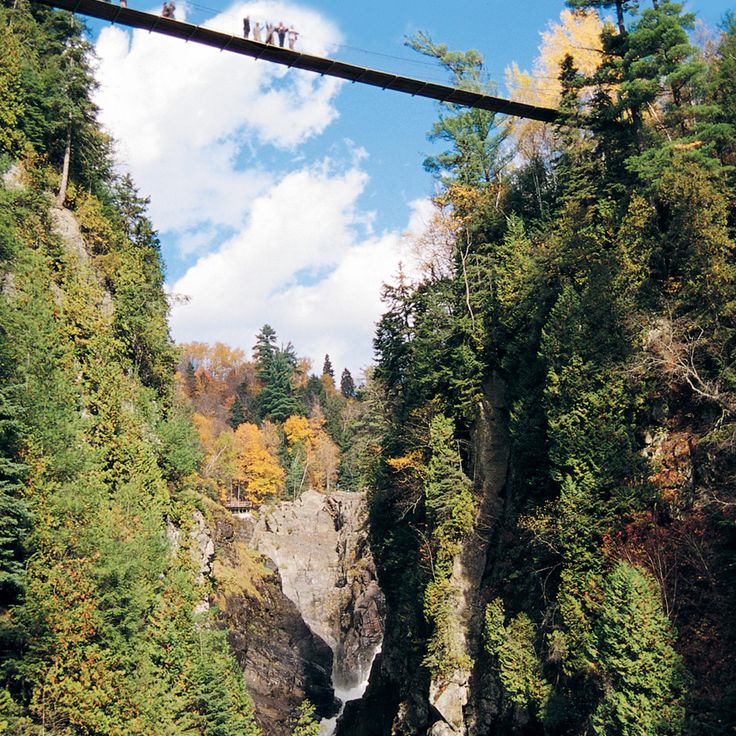
This gorge in the Eastern Townships forms a 150-meter deep canyon carved by the Coaticook River. A 169-meter pedestrian suspension bridge spans the formation, positioned 50 meters above the riverbed. The walking trail along the rock walls extends for 2.2 miles through forested areas and provides views of waterfalls and geological layers. After dark, portions of the gorge and the suspension bridge are illuminated through colored lighting installations that operate nightly during summer months.
Sacacomie Lake in the Mauricie region provides a range of photographic subjects across all seasons. The calm water reflects the surrounding forest and creates opportunities for landscape shots that document Quebec's natural environment. Water sports enthusiasts on the lake add human elements to summer compositions, while winter months reveal ice fishermen and snow-covered shoreline scenes. The hiking trails through the surrounding forest enable captures of tree canopies, wildlife, and seasonal changes in vegetation characteristic of this region.
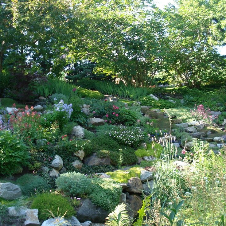
Les Jardins de Métis contains over 3,000 plant species on a historic estate along the St. Lawrence River. This horticultural site serves as a testing ground for international landscape architects who develop and present new design concepts here. The grounds feature rotating installations of contemporary garden art alongside established historic plantings. Visitors find documented projects in garden design and can follow the development of experimental plant arrangements. The site connects traditional gardening practices with modern approaches to landscape architecture.
The Lieu historique national de la Bataille-de-la-Ristigouche documents the 1760 naval engagement between France and Britain on the Restigouche River. This Quebec site presents artifacts from the French frigate Machault's wreck and demonstrates through exhibits how this French naval defeat sealed the end of French colonial rule in North America. The grounds provide access to the shoreline where visitors can understand this decisive maritime confrontation. The interpretation center and archaeological finds convey the strategic importance of this event within the broader context of French-British colonial rivalry.
This 83-meter (270-foot) waterfall provides year-round photography subjects, from summer cascades to frozen ice formations in winter. Montmorency Falls sits a few miles northeast of Quebec City along the Saint Lawrence River and ranks among the province's notable natural sites. A suspension bridge at the top allows photographers to capture different perspectives, while staircases and a cable car system provide access to viewpoints at the base and summit. The falls drop over a cliff into the Montmorency River, creating constant spray that offers photographic opportunities under certain light conditions.
This UNESCO World Heritage site represents Quebec's French colonial architecture and forms a central location within the province's photography settings. Old Quebec displays 17th and 18th century buildings, including merchant houses with stone facades, the Citadel and preserved fortifications. The cobblestone streets run through neighborhoods where limestone structures document religious and administrative functions from the colonial period. This district provides subjects ranging from defensive walls to narrow lanes lined with historical facades, complementing the natural landmarks and urban locations that define photography opportunities across Quebec.
This luxury hotel, built in 1893 in French castle style, stands on Dufferin Terrace and offers views over the Saint Lawrence River. Fairmont Le Château Frontenac defines the skyline of Upper Town Quebec and ranks among Canada's most photographed structures. The building's towers and copper roofs combine European architectural elements with Canadian history, documenting the city's development as a trading and administrative center. For photographers, the hotel provides numerous perspectives, from the riverside promenade to the surrounding streets of the Old Town, capturing both its exterior grandeur and its place within the historic district.
This park north of Old Quebec contains an 83-meter waterfall on the Saint Lawrence River and provides multiple vantage points for photography. A cable car connects the lower and upper levels, and walking trails lead through the forested area surrounding Chute-Montmorency. The grounds include several platforms, among them a suspension bridge at the top of the falls that offers views of the river and surrounding landscape. The park operates year-round and winter months transform the falls into an ice sculpture, while spring and fall provide different lighting conditions for shooting.
This 98-hectare (240-acre) park occupies a plateau above the St. Lawrence River and was the site of a decisive 1759 battle between British and French forces. The Plains of Abraham now serve as Quebec City's central green space, hosting the National Museum of Fine Arts of Quebec along with regular concerts, sports events and cultural activities. The grounds include walking paths, open lawns and historical monuments that mark key moments from the battle. The park connects to the wider Battlefields Park system and provides views across the river valley.
This neo-Romanesque church was built in 1926 and serves as a major pilgrimage site along the Saint Lawrence River. The Basilica of Sainte-Anne-de-Beaupré features religious scenes rendered in stained glass windows and mosaics, offering photographers opportunities to capture liturgical art and architectural details. The interior extends 328 feet (100 meters) in length and provides multiple perspectives for architectural photography. As part of Quebec's photo locations, this basilica complements the province's documentation of religious structures alongside its historic buildings and natural landmarks.
This island in the Saint Lawrence River comprises six historical villages connected by a 42-mile (67-kilometer) ring road. Île d'Orléans preserves French Canadian architecture from the 18th and 19th centuries, including stone churches, farmhouses, and manor homes. The agricultural tradition shows through orchards, vineyards, and family operations producing cider, maple products, and cheese. Photographers find rural landscapes along the river, traditional buildings, and seasonal harvest fields that characterize Quebec as a photography destination.
Le Massif de Charlevoix extends across 770 meters (2,526 feet) of vertical drop and provides views of the Saint Lawrence River. The ski resort contains 53 runs used for downhill skiing in winter, while trails serve hikers during summer months. The combination of alpine terrain and river proximity creates subjects that showcase both mountain sports and maritime elements within Quebec's Charlevoix region. This resort serves as a location for capturing winter activities against the river backdrop or for landscape photography documenting the geographic particularity of these coastal mountains.
Mont-Tremblant is a winter sports area in the Laurentian Mountains with 96 ski trails across varying difficulty levels. The gondola reaches the 875-meter (2,871-foot) summit, providing views of the surrounding mountain terrain. The village at the base follows a French Alpine architectural style, housing restaurants, shops and lodging. This location offers photography subjects including ski slopes, mountain landscapes and the uniform village architecture. During summer, the trails convert to hiking paths while Lac Tremblant adds water-based compositions. Mont-Tremblant ranks among the notable photography sites in Quebec, combining athletic activities with mountainous natural settings and deliberate architectural planning.
This 550-square-mile (1,400-square-kilometer) national park protects the deep valleys and river systems of the Jacques-Cartier River, about 25 miles (40 kilometers) north of Quebec City. The reserve provides habitat for moose and white-tailed deer that inhabit the forested slopes and river valleys. The park contains several hiking trails that access the cliffs and viewpoints along the river. The landscape works for nature photography of the Laurentian Mountains and the river bends that wind through the valley. In winter, the area transforms into a destination for snowshoeing and cross-country skiing.
This geodesic structure on Île Sainte-Hélène was originally designed as the United States pavilion for Expo 67 and later converted into an environmental museum. The Biosphère now houses exhibits on water systems, climate change and sustainable development in the Saint Lawrence River ecosystem. The 200-foot steel and acrylic structure offers photographers geometric patterns and reflections against Montreal's skyline. Its island location in the river allows for shots of the dome with urban backdrop or natural riverbank vegetation. The structure serves as an architectural example of mid-century design and as a working educational center for environmental topics in Quebec.
La Grande Roue de Montréal stands in the Old Port and serves as a modern landmark in the city. The climate-controlled cabins rise to 200 feet (61 meters) and offer views across the Saint Lawrence River, Old Montreal and the surrounding boroughs. Opened in 2017, this observation wheel operates year-round, allowing visitors to photograph the city from an elevated vantage point in any season. The wheel occupies a central position along the waterfront and provides a base for capturing urban panoramas and river landscapes.
This basilica ranks among the most significant examples of Gothic Revival architecture in Quebec. Completed in 1829, the church presents an interior featuring carved wood elements created by craftsmen from Quebec and Europe. The stained glass windows depict scenes from Montreal's history rather than traditional biblical narratives. The altar received gold leaf treatment, while the blue ceiling displays golden stars. The church offers photographic subjects ranging from architectural details to liturgical objects and the interplay of natural and artificial light through the colored windows.
The Quartier Petit Champlain sits at the base of the cliff below the Château Frontenac, forming one of the oldest commercial districts in North America. This pedestrian zone spans several short cobblestone streets lined with two and three story buildings from the 17th and 18th centuries, now housing local boutiques, art galleries and restaurants. Multiple building facades display large scale murals depicting historical scenes from the city's past. The main thoroughfare, Rue du Petit-Champlain, connects the lower harbor area to the Breakneck Steps stairway that climbs to the upper town. This quarter documents French colonial architecture and provides photographic compositions with the steep rock face of Cap Diamant rising behind the streetscapes.
Saint Joseph's Oratory sits on the western slope of Mount Royal overlooking Montreal. Completed in 1967, this Roman Catholic minor basilica features a copper dome that rises 320 feet (97 meters) and ranks among the largest of its kind in the world. The site encompasses multiple levels with gardens, chapels and observation points that provide views across the city and surrounding mountain ranges. The complex attracts about two million visitors each year and serves as an important pilgrimage destination. Interior spaces display stained glass windows, mosaics and a crypt housing the tomb of Brother André, the founder. The elevated position on Mount Royal allows photographers to capture both architectural details of the dome and wide perspectives that frame the oratory within its urban context.
This protected area spans 7,861 square kilometers (3,036 square miles) in northern Quebec, providing photographers with access to boreal forests, more than 2,000 lakes, and diverse wildlife. The Laurentides Wildlife Reserve supports populations of moose, deer, and beaver within its natural habitat. The extensive coniferous forests and waterways create opportunities for wildlife and landscape photography. The reserve operates as a controlled recreation area with designated zones for animal observation.
This market spans several city blocks in the Little Italy neighborhood and has operated since 1933, offering regional products from Quebec farmers and vendors. Jean-Talon Market contains more than 150 stalls selling fruits, vegetables, cheeses, meats, baked goods and maple products that reflect the province's agricultural output. The 1930s architecture features covered walkways and open-air sections that provide photographic subjects including product displays, vendor-customer interactions and seasonal produce arrangements. As Montreal's largest public market, this location demonstrates Quebec's food traditions within a working commercial environment that serves both residents and visitors throughout the year.
The Morrin Centre was originally a Victorian prison that operated between 1808 and 1867. The building now houses an English-language library, a cultural center and a small museum documenting the history of Quebec's anglophone community. The former prison cells in the basement are accessible during guided tours and show the detention conditions of the 19th century. The library on the first floor contains historical collections and serves as a gathering place for cultural events. As a photography location in Quebec, the Morrin Centre offers a connection between Victorian architecture and institutional history in Old Quebec City.
This canyon near Beaupré cuts 74 meters (240 feet) into the bedrock, forming a gorge that displays the erosive power of water over geological time. Three fixed suspension bridges cross at different elevations, providing views of the waterfall that flows through the gorge. Paved pathways follow the canyon rim and descend partway into the chasm, while two zip lines span the width of the gorge above the water. The site demonstrates how the Sainte-Anne River has carved through Precambrian rock formations common to this part of Quebec.
This historic stone staircase connects the Upper Town with the Lower Town in Quebec City, bridging several elevation levels between the Château Frontenac and the harbor district. The Frontenac Staircase comprises 59 steps flanked by flower beds, providing a direct pedestrian route through the fortified old town. The staircase serves as both a practical link between the two levels and a vantage point overlooking the Saint Lawrence River. Photographers find angles here capturing the French colonial architecture, stone fortifications, and layered structure of the historic city, particularly during early morning hours or at dusk.
This cathedral basilica dates from the 17th century and displays French architecture with stained glass windows and a gold decorated ceiling. The interior contains religious artworks and offers photographers opportunities to capture details of colonial ecclesiastical architecture typical of Quebec City's historic district. The basilica serves as an example of French church tradition in North America and allows shots of liturgical elements and architectural details that document European influence on the province's religious building practices.
This railway bridge with its distinctive metal structure crosses the Cap-Rouge River at a height of 164 feet (50 meters) and has connected both banks since 1908. The Tracel Bridge stands among the historic infrastructure works in the Quebec region and offers photographers opportunities to capture industrial architecture alongside the natural river landscape. The structure displays typical early twentieth-century engineering elements and fits within the range of photography locations that span from the stone architecture of Old Quebec to natural landmarks such as Montmorency Falls.
The Observatoire de la Capitale offers the highest public viewpoint in Quebec City. This observation deck on the 31st floor of the Marie-Guyart Building provides a 360-degree view over Old Quebec, the Saint Lawrence River, and the surrounding Laurentian Mountains. At 721 feet (221 meters) above sea level, the platform allows photographers to capture the entire city layout, including its historic quarters and modern districts. Floor-to-ceiling windows enable unobstructed shooting in all directions. This vantage point documents the city's geography at the confluence of the Saint Lawrence and Saint Charles rivers, as well as the extent of urban development spreading across both riverbanks.
This modern museum in Québec City presents interactive exhibitions on human history and regional traditions. The collections include archaeological findings, ethnographic objects and historical artifacts documenting the development of society in Québec. Visitors explore galleries on Indigenous cultures, French colonial history and contemporary life in the province. Rotating special exhibitions complement the permanent displays with themes from anthropology, social history and everyday culture.
This main street connects the Parliament Building to the Plains of Abraham and runs through one of the city's busiest districts. Grande-Allée contains 19th-century mansions that now house restaurants, bars and boutiques. The wide avenue offers clear sightlines to architectural details along its length. Photographers find subjects ranging from Victorian architecture to contemporary urban life here. The street serves as a transition between government districts and the historic battlefields, with each section presenting different visual elements.
The Lachine Canal runs for 14.5 kilometers, linking the Saint Lawrence River to Montreal's harbor through a series of locks. Built in the 19th century for commercial shipping, the waterway was later decommissioned and reopened in the 1990s as a public recreation corridor. Former industrial buildings in brick and stone line the banks, now converted to residences, offices and galleries. Paved cycling and walking paths run along both sides of the canal, offering access to green spaces and resting areas. The five lock systems remain operational, allowing boat traffic during summer months. Anglers, kayakers and cyclists use the canal regularly, and several bridges cross the waterway, connecting adjacent Montreal neighborhoods.
This peninsula extends 200 kilometers (125 miles) along the Saint Lawrence River and provides photographers with access to cliffs, lighthouses and fishing villages. The area includes Forillon National Park with its coastal formations and Percé Rock, which rises 88 meters (290 feet) above the water. The region displays maritime architecture in communities like Percé and Gaspé, while the coastline alternates between rocky shores and sand beaches. Fog and changing light conditions from the river's influence create varied conditions for coastal and architectural photography in this collection of Quebec locations.
This nature park on the Gaspésie coast presents Canadian wildlife in naturalistic enclosures and offers a network of paths through forested terrain. Bioparc de la Gaspésie displays native species including black bears, beavers and lynx in habitats that replicate their natural environments. Visitors can explore different ecosystems along the woodland trails, while interactive stations provide information about regional fauna. The facility serves both wildlife observation and environmental education, allowing close-range photography of animals in controlled outdoor settings that mimic Quebec's natural landscapes.
This boulevard displays murals and graffiti art by artists from Montreal and around the world along several kilometers of wall space. Boulevard Saint-Laurent serves as an urban photography subject in Quebec's largest city, where street art spans different styles and techniques. The artworks change regularly through new additions and reflect contemporary cultural themes. Photographers find examples of urban art here that contrast with Quebec's historical architectural elements and document the city's modern artistic development. The street provides accessible vantage points for capturing large-scale public art within the metropolitan environment.
This island in the Saint Lawrence River provides multiple subjects documenting Quebec's rural heritage within a compact setting. Île aux Coudres contains two historic windmills dating from the 18th century, preserved as working examples of traditional grain processing. A 14-mile (23-kilometer) cycling path circles the island, providing access to agricultural landscapes and villages with 19th-century houses. Apple orchards cover portions of the island, creating structured compositions during bloom and harvest periods. The river setting produces perspectives with water in the foreground and the Charlevoix mountains as backdrop. Fishing houses and barns along the coastal road display elements of maritime architecture in wood construction.
The Parc National des Hautes-Gorges-de-la-Rivière-Malbaie documents the landscape formations of the Charlevoix region through its 800-meter (2,600-foot) rock walls rising along the Rivière Malbaie. This national park offers photographers subjects ranging from steep cliff faces to forested slopes and the river system that cuts through the gorge. The hiking trail network leads to overlooks where the proportions of the gorge and geological structures become visible. Kayaking on the river provides water-level perspectives, while vegetation shifts with seasons to deliver different color palettes for landscape photography.
Le Parc des Chutes Coulonge presents several waterfalls along a nature trail in an area once shaped by the logging industry. The park combines Quebec's natural landscapes with recreational activities including tree climbing and zip lines. The waterfalls and forested sections provide photographic subjects that capture both flowing water and the province's dense woodlands. The site documents the region's industrial past while the walking paths offer access to different vantage points overlooking the falls. Nature photography and activity scenes are among the photographic opportunities at this location.
This national park covers 33 square miles (86 square kilometers) along the Saint Lawrence River, offering photographers rock cliffs, sheltered bays, and tidal zones with large seal colonies. The coastal landscape combines geological formations with marine ecosystems, while tides create shifting perspectives throughout the day. Located east of Rimouski, the park marks the transition between river estuary and gulf, with trails providing access to elevated viewpoints above the water. Photographic opportunities include coastal panoramas, wildlife observation, and the interplay between land and sea at different tidal stages.
This gorge in the Eastern Townships forms a 150-meter deep canyon carved by the Coaticook River. A 169-meter pedestrian suspension bridge spans the formation, positioned 50 meters above the riverbed. The walking trail along the rock walls extends for 2.2 miles through forested areas and provides views of waterfalls and geological layers. After dark, portions of the gorge and the suspension bridge are illuminated through colored lighting installations that operate nightly during summer months.
Sacacomie Lake in the Mauricie region provides a range of photographic subjects across all seasons. The calm water reflects the surrounding forest and creates opportunities for landscape shots that document Quebec's natural environment. Water sports enthusiasts on the lake add human elements to summer compositions, while winter months reveal ice fishermen and snow-covered shoreline scenes. The hiking trails through the surrounding forest enable captures of tree canopies, wildlife, and seasonal changes in vegetation characteristic of this region.
Les Jardins de Métis contains over 3,000 plant species on a historic estate along the St. Lawrence River. This horticultural site serves as a testing ground for international landscape architects who develop and present new design concepts here. The grounds feature rotating installations of contemporary garden art alongside established historic plantings. Visitors find documented projects in garden design and can follow the development of experimental plant arrangements. The site connects traditional gardening practices with modern approaches to landscape architecture.
The Lieu historique national de la Bataille-de-la-Ristigouche documents the 1760 naval engagement between France and Britain on the Restigouche River. This Quebec site presents artifacts from the French frigate Machault's wreck and demonstrates through exhibits how this French naval defeat sealed the end of French colonial rule in North America. The grounds provide access to the shoreline where visitors can understand this decisive maritime confrontation. The interpretation center and archaeological finds convey the strategic importance of this event within the broader context of French-British colonial rivalry.