Enable Location

We need your location to show you interesting places around you

Discover nearby places

Find interesting locations and hidden gems around you

Precise directions

Get accurate directions and distances to places

Your location is never shared with other users. It's only used when you tap the location button.

Interstate 55

Log in to your account

Start exploring — it's free

Trusted by 63,025 travelers worldwide

Continue with Google
Continue with Apple
or

We will send you a code to connect

By continuing, you accept our Terms and Conditions and our Privacy Policy

Check your inbox

We've sent a pincode in your inbox. Please enter the code below.

Interstate 55
Discussion Reviews 1 Photos
56.3k Popularity

Interstate 55, Federal highway from Louisiana to Illinois, United States.

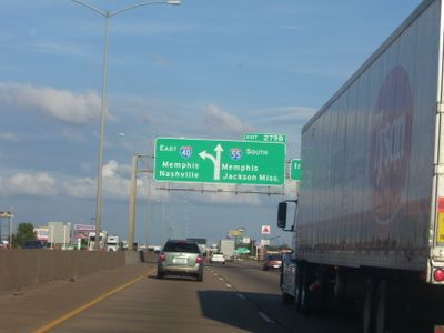
Interstate 55 is a federal highway that stretches 964 miles (1,551 km) through Louisiana, Mississippi, Tennessee, Arkansas, Missouri and Illinois, linking New Orleans to Chicago. It crosses farmland, Gulf Coast wetlands and urban centers like Memphis and St. Louis.

Construction began in 1957 as part of the nationwide Interstate project and replaced portions of old Route 66 in Missouri and Illinois. The final section opened in 1979, creating the continuous link between the Gulf of Mexico and the Great Lakes.

The route follows much of the Mississippi River valley and links regions shaped by different traditions, from jazz in Louisiana to blues in Tennessee. Many places along the way preserve memories of the civil rights movement that traveled through these areas in the 1960s.

Fuel stations and rest areas with food and lodging appear regularly, roughly every 50 miles along the entire route. Traffic can become heavier during morning hours around Memphis, St. Louis and Chicago.

In southern Louisiana the route crosses the Manchac Swamp on a bridge that extends nearly 23 miles (37 km), making it one of the longest bridges in the continent. Drivers here often see water stretching to the horizon on both sides.

The community of curious travelers

AroundUs brings together thousands of curated places, local tips, and hidden gems, enriched daily by 60,000 contributors worldwide.

Start exploring
Location
Location
Location
Location
Location
Location
Inception
1957
GPS coordinates
41.36264,-88.19210
Latest update
December 13, 2025 20:00
Around this place
Chicagoland Speedway
United States of America

Chicagoland Speedway

16.8 km
United States of America

Mazon Creek

13.7 km
Abraham Lincoln National Cemetery
United States of America

Abraham Lincoln National Cemetery

6.3 km
Gemini Giant
United States of America

Gemini Giant

7.3 km
United States of America

Kankakee Torrent

6.6 km
Harrah's Joliet
United States of America

Harrah's Joliet

20.4 km
Rialto Square Theatre
United States of America

Rialto Square Theatre

20.4 km
Cathedral of St. Raymond Nonnatus
United States of America

Cathedral of St. Raymond Nonnatus

20.7 km
Hiram B. Scutt Mansion
United States of America

Hiram B. Scutt Mansion

20.2 km
United States of America

Argosy Empress Casino

13.5 km
United States of America

Goose Lake Prairie State Natural Area

8.8 km
Joliet East Side Historic District
United States of America

Joliet East Side Historic District

20 km
Des Plaines State Fish and Wildlife Area
United States of America

Des Plaines State Fish and Wildlife Area

3.7 km
Channahon State Park
United States of America

Channahon State Park

7.5 km
Gebhard Woods State Park
United States of America

Gebhard Woods State Park

20.3 km
Brandon Road Lock and Dam
United States of America

Brandon Road Lock and Dam

17.3 km
Christ Episcopal Church
United States of America

Christ Episcopal Church

20.3 km
Briscoe Mounds
United States of America

Briscoe Mounds

6.8 km
Dresden Island Lock and Dam Historic District
United States of America

Dresden Island Lock and Dam Historic District

8.5 km
Upper Bluff Historic District
United States of America

Upper Bluff Historic District

20.2 km
United States Post Office
United States of America

United States Post Office

20.6 km
Morris Bridge
United States of America

Morris Bridge

19.2 km
White and Company's Goose Lake Tile Works
United States of America

White and Company's Goose Lake Tile Works

10.6 km
Morris Wide Water Canal Boat Site
United States of America

Morris Wide Water Canal Boat Site

17.7 km
Small–Towle House
United States of America

Small–Towle House

7.1 km
White and Company's Goose Lake Stoneware Manufactury
United States of America

White and Company's Goose Lake Stoneware Manufactury

11 km
Brandon Road Bridge
United States of America

Brandon Road Bridge

17.2 km
Morris Theater
United States of America

Morris Theater

19.3 km
Show the full map
Reviews
Share your experience

No review yet

Discussions
Start a discussion...

No discussion yet

« Interstate 55 - Federal highway from Louisiana to Illinois, United States » is provided by Around Us (aroundus.com). Images and texts are derived from Wikimedia project under a Creative Commons license. You are allowed to copy, distribute, and modify copies of this page, under the conditions set by the license, as long as this note is clearly visible.

Discover hidden gems everywhere you go!

From secret cafés to breathtaking viewpoints, skip the crowded tourist spots and find places that match your style. Our app makes it easy with voice search, smart filtering, route optimization, and insider tips from travelers worldwide. Download now for the complete mobile experience.

Around Us App Screenshot

A unique approach to discovering new places

Le Figaro

All the places worth exploring

France Info

A tailor-made excursion in just a few clicks

20 Minutes

Around Us
Travel Guide & Maps
Download

Send to your phone

QR Code
1

Open the camera app on your mobile.

2

Point at the QR code with your camera. A notification will appear.

3

Tap the notification to open the link.