Chest opened
+${chestReward.xp} XP
Explorer
NOUVEAU ×${chestReward.collectible.quantity}
tapez pour fermer
Chest locked

Open chests in the app

Around Us is built for your phone — chests unlock when you walk, explore and capture nearby places.

Enable Location

We need your location to show you interesting places around you

Discover nearby places

Find interesting locations and hidden gems around you

Precise directions

Get accurate directions and distances to places

Your location is never shared with other users. It's only used when you tap the location button.

Assateague Island

Log in to your account

Start exploring — it's free

Trusted by 72,950 travelers worldwide

Continue with Google
Continue with Apple
or

We will send you a code to connect

By continuing, you accept our Terms and Conditions and our Privacy Policy

Check your inbox

We've sent a pincode in your inbox. Please enter the code below.

Assateague Island
Discussion Reviews 1 Photos
119k Popularity

Assateague Island, Barrier island in Worcester County, United States

Assateague Island is a barrier island stretching 37 miles (59 kilometers) along the Atlantic coast of Maryland and Virginia, composed of sandy beaches, dunes, and shallow waters. The terrain shifts between open sandy shore on the ocean side and protected bays with reeds and low vegetation on the mainland side.

A storm in 1933 opened a permanent channel between the ocean and bay in the north, reshaping the coastline over the following decades. The government later established protected zones to safeguard the natural evolution of the landscape.

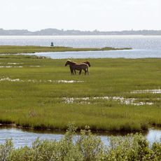
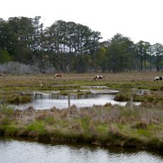
The northern section is home to free-roaming horses that have become part of the local identity and are watched by visitors from a respectful distance. These animals shape daily life on the island and their presence gives the place a special character.

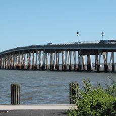
The visitor pavilion west of the Verrazano Bridge offers information and maps for navigating the area. Day trips work well for beach walks and wildlife watching, while overnight stays are possible in designated areas.

Horses living on the island likely descend from animals settled here in the 17th century and adapted to harsh conditions. Their herds move freely through dunes and coastal strips year-round.

The community of curious travelers

AroundUs brings together thousands of curated places, local tips, and hidden gems, enriched daily by 60,000 contributors worldwide.

Start exploring
Location
Location
Shares border with
Snow Hill
GPS coordinates
38.09179,-75.20380
Latest update
December 15, 2025 22:30
Around this place
Assateague State Park
United States of America

Assateague State Park

16.2 km
Chincoteague National Wildlife Refuge
United States of America

Chincoteague National Wildlife Refuge

18.2 km
Assateague Light
United States of America

Assateague Light

24.1 km
Verrazano Bridge
United States of America

Verrazano Bridge

17.8 km
Rackliffe House
United States of America

Rackliffe House

25.4 km
Sun Outdoors Frontier Town
United States of America

Sun Outdoors Frontier Town

22.9 km
Captain Timothy Hill House
United States of America

Captain Timothy Hill House

20.9 km
Governor John Walter Smith House
United States of America

Governor John Walter Smith House

19 km
Merry Sherwood
United States of America

Merry Sherwood

23.9 km
United States of America

Julia A. Purnell Museum

19.3 km
Museum of Chincoteague Island
United States of America

Museum of Chincoteague Island

22.6 km
Burley Manor
United States of America

Burley Manor

25.4 km
United States of America

E.A. Vaughn Wildlife Management Area

15.4 km
United States of America

Mount Zion One Room School

18.8 km
Genesar
United States of America

Genesar

16 km
George Washington Purnell House
United States of America

George Washington Purnell House

19.1 km
United States of America

Sinepuxent Bay Wildlife Management Area

16.8 km
Berlin Commercial District
United States of America

Berlin Commercial District

26 km
United States of America

Girdletree Barnes Bank

17 km
Assateague Beach Coast Guard Station
United States of America

Assateague Beach Coast Guard Station

29.2 km
James Martin House
United States of America

James Martin House

18.9 km
Samuel Gunn House
United States of America

Samuel Gunn House

19.3 km
Chanceford
United States of America

Chanceford

19.1 km
Refuge Waterfowl Museum
United States of America

Refuge Waterfowl Museum

22.8 km
Chincoteague Island Library
United States of America

Chincoteague Island Library

23.2 km
Watson House
United States of America

Watson House

22.7 km
United States of America

Fassitt House

22.2 km
Simpson's Grove
United States of America

Simpson's Grove

21.1 km
Show the full map
Reviews
Share your experience

No review yet

Discussions
Start a discussion...

No discussion yet

« Assateague Island - Barrier island in Worcester County, United States » is provided by Around Us (aroundus.com). Images and texts are derived from Wikimedia project under a Creative Commons license. You are allowed to copy, distribute, and modify copies of this page, under the conditions set by the license, as long as this note is clearly visible.

Discover hidden gems everywhere you go!

From secret cafés to breathtaking viewpoints, skip the crowded tourist spots and find places that match your style. Our app makes it easy with voice search, smart filtering, route optimization, and insider tips from travelers worldwide. Download now for the complete mobile experience.

Around Us App Screenshot

A unique approach to discovering new places

Le Figaro

All the places worth exploring

France Info

A tailor-made excursion in just a few clicks

20 Minutes

Around Us
Travel Guide & Maps
Download

Send to your phone

QR Code
1

Open the camera app on your mobile.

2

Point at the QR code with your camera. A notification will appear.

3

Tap the notification to open the link.