Enable Location

We need your location to show you interesting places around you

Discover nearby places

Find interesting locations and hidden gems around you

Precise directions

Get accurate directions and distances to places

Your location is never shared with other users. It's only used when you tap the location button.

Shannon County

Log in to your account

Start exploring — it's free

Trusted by 61,887 travelers worldwide

Continue with Google
Continue with Apple
or

We will send you a code to connect

By continuing, you accept our Terms and Conditions and our Privacy Policy

Check your inbox

We've sent a pincode in your inbox. Please enter the code below.

Shannon County, Administrative county in southern Missouri, US

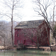
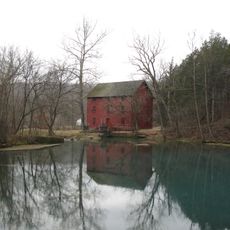
Shannon County is an administrative county in southern Missouri comprising several small towns and rural communities. Eminence serves as the county seat and holds historical records dating back to the 1800s.

The county was established in 1841 and named for George Shannon, a member of the Lewis and Clark Expedition. Early economic development relied on mining operations that attracted settlers to the region.

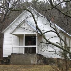
The county contains multiple Protestant churches, with Southern Baptist congregations forming the predominant religious presence in local communities.

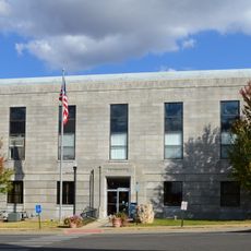
Visitors should head to Eminence to explore the courthouse and learn about the region's past. The warmer months offer the best conditions for traveling and visiting outdoor areas throughout the county.

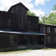
Missouri's first copper mining operation began here in 1846, revealing the region's early industrial role. Decades later, the area became home to the state's only manganese mining during World War II, boosting local economy during wartime.

The community of curious travelers

AroundUs brings together thousands of curated places, local tips, and hidden gems, enriched daily by 60,000 contributors worldwide.

Start exploring
Location
Inception
1841
Capital city
Eminence
Shares border with
Dent County, Texas County, Oregon County, Howell County, Reynolds County, Carter County
GPS coordinates
37.16000,-91.40000
Latest update
December 7, 2025 19:26
Around this place
Taum Sauk Mountain
United States of America

Taum Sauk Mountain

75 km
Johnson's Shut-Ins State Park
United States of America

Johnson's Shut-Ins State Park

65.2 km
United States of America

Echo Bluff State Park

16.9 km
Taum Sauk Mountain State Park
United States of America

Taum Sauk Mountain State Park

75 km
Bell Mountain Wilderness
United States of America

Bell Mountain Wilderness

70 km
Greer Spring
United States of America

Greer Spring

41.8 km
Dillard Mill State Historic Site
United States of America

Dillard Mill State Historic Site

64.4 km
Eleven Point State Park
United States of America

Eleven Point State Park

63.7 km
Current River State Park
United States of America

Current River State Park

18.3 km
Roger Pryor Pioneer Backcountry
United States of America

Roger Pryor Pioneer Backcountry

20.5 km
Jay Nixon State Park
United States of America

Jay Nixon State Park

73 km
Current River Cavern
United States of America

Current River Cavern

38.3 km
Alley Spring Roller Mill
United States of America

Alley Spring Roller Mill

3.8 km
United States of America

Mount Zion Lodge Masonic Temple

62.6 km
Courthouse Square Historic District
United States of America

Courthouse Square Historic District

62.6 km
Walter Klepzig Mill and Farm
United States of America

Walter Klepzig Mill and Farm

18.2 km
Dent County Courthouse
United States of America

Dent County Courthouse

55.4 km
Alton Club
United States of America

Alton Club

18.5 km
Big Spring Historic District
United States of America

Big Spring Historic District

43.1 km
Reed Log House
United States of America

Reed Log House

20.5 km
Alley Spring
United States of America

Alley Spring

3.7 km
Montauk State Park
United States of America

Montauk State Park

41 km
Montauk State Park Open Shelter
United States of America

Montauk State Park Open Shelter

41.2 km
Carter County Courthouse
United States of America

Carter County Courthouse

38.9 km
Lower Parker School
United States of America

Lower Parker School

36.9 km
Old Mill at Montauk State Park
United States of America

Old Mill at Montauk State Park

41 km
Baldy Lookout Tower
United States of America

Baldy Lookout Tower

52.6 km
Possum Trot Lookout
United States of America

Possum Trot Lookout

26.5 km
Show the full map
Administrative divisions
« Shannon County - Administrative county in southern Missouri, US » is provided by Around Us (aroundus.com). Images and texts are derived from Wikimedia project under a Creative Commons license. You are allowed to copy, distribute, and modify copies of this page, under the conditions set by the license, as long as this note is clearly visible.

Discover hidden gems everywhere you go!

From secret cafés to breathtaking viewpoints, skip the crowded tourist spots and find places that match your style. Our app makes it easy with voice search, smart filtering, route optimization, and insider tips from travelers worldwide. Download now for the complete mobile experience.

Around Us App Screenshot

A unique approach to discovering new places

Le Figaro

All the places worth exploring

France Info

A tailor-made excursion in just a few clicks

20 Minutes

Around Us
Travel Guide & Maps
Download

Send to your phone

QR Code
1

Open the camera app on your mobile.

2

Point at the QR code with your camera. A notification will appear.

3

Tap the notification to open the link.