Chest opened
+${chestReward.xp} XP
Explorer
NOUVEAU ×${chestReward.collectible.quantity}
tapez pour fermer
Chest locked

Open chests in the app

Around Us is built for your phone — chests unlock when you walk, explore and capture nearby places.

Enable Location

We need your location to show you interesting places around you

Discover nearby places

Find interesting locations and hidden gems around you

Precise directions

Get accurate directions and distances to places

Your location is never shared with other users. It's only used when you tap the location button.

Kentucky River

Log in to your account

Start exploring — it's free

Trusted by 72,901 travelers worldwide

Continue with Google
Continue with Apple
or

We will send you a code to connect

By continuing, you accept our Terms and Conditions and our Privacy Policy

Check your inbox

We've sent a pincode in your inbox. Please enter the code below.

Kentucky River
Discussion Reviews 2 Photos
27.9k Popularity

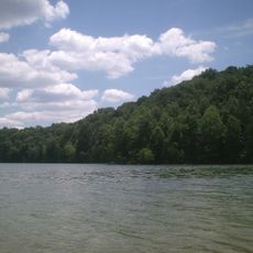
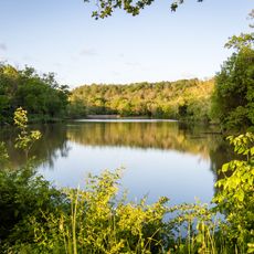
Kentucky River, River system in central Kentucky, United States.

The Kentucky River is a waterway in central Kentucky that flows for approximately 259 miles through the state's interior regions. It gathers water from three major tributaries before joining the Ohio River at Carrollton, creating an important water pathway across the area.

During the 1800s the waterway served as a vital trade route for moving timber, coal, and goods across the state's interior. Transportation by water declined as railways and roads later expanded throughout Kentucky.

Local communities along the Kentucky River maintain fishing traditions and organize regular water-based events that bring residents together throughout the year.

This waterway supplies drinking water to many communities in the state, including the cities of Lexington, Winchester, and Richmond. Water access varies by section, and some areas are harder to reach than others, so planning ahead helps determine the best visiting location.

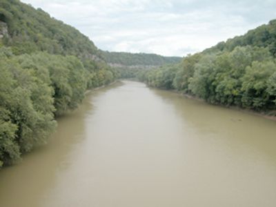
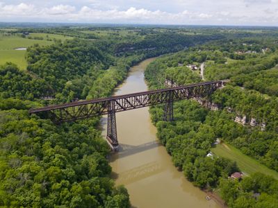
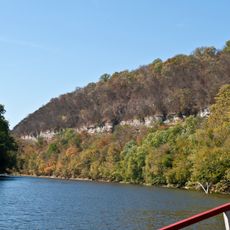
The Palisades section of this waterway features dramatic limestone cliffs extending about 100 miles between Clays Ferry and Frankfort. These gorges cut roughly 400 feet deep into the landscape, creating a distinctive geological formation in this part of the river.

The community of curious travelers

AroundUs brings together thousands of curated places, local tips, and hidden gems, enriched daily by 60,000 contributors worldwide.

Start exploring
Location
GPS coordinates
37.56953,-83.71019
Latest update
December 20, 2025 13:14
Around this place
Ark Encounter
United States of America

Ark Encounter

140.4 km
Buffalo Trace Distillery
United States of America

Buffalo Trace Distillery

124.8 km
Keeneland
United States of America

Keeneland

95.3 km
Kroger Field
United States of America

Kroger Field

86.2 km
Kentucky State Capitol
United States of America

Kentucky State Capitol

123.3 km
Kentucky Horse Park
United States of America

Kentucky Horse Park

96.1 km
Frankfort Cemetery
United States of America

Frankfort Cemetery

123.4 km
Fort Boonesborough State Park
United States of America

Fort Boonesborough State Park

61.4 km
Boone Tavern
United States of America

Boone Tavern

51 km
Pleasant Hill
United States of America

Pleasant Hill

94.9 km
Kentucky Governor's Mansion
United States of America

Kentucky Governor's Mansion

123.2 km
Mary Todd Lincoln House
United States of America

Mary Todd Lincoln House

88 km
Ashland
United States of America

Ashland

84.8 km
High Bridge of Kentucky
United States of America

High Bridge of Kentucky

93.1 km
Herrington Lake
United States of America

Herrington Lake

89.6 km
Roy Kidd Stadium
United States of America

Roy Kidd Stadium

54.9 km
Old Friends Equine
United States of America

Old Friends Equine

103.3 km
General Butler State Resort Park
United States of America

General Butler State Resort Park

176.1 km
John Brett Richeson House
United States of America

John Brett Richeson House

120 km
Perryville Battlefield State Historic Site
United States of America

Perryville Battlefield State Historic Site

111.7 km
White Hall
United States of America

White Hall

63.7 km
Old Fort Harrod State Park
United States of America

Old Fort Harrod State Park

102.6 km
John Hunt Morgan Memorial
United States of America

John Hunt Morgan Memorial

89.1 km
Lexington Financial Center
United States of America

Lexington Financial Center

87.4 km
Aviation Museum of Kentucky
United States of America

Aviation Museum of Kentucky

93.6 km
Kentucky River Palisades
United States of America

Kentucky River Palisades

83.7 km
CentrePointe, Lexington
United States of America

CentrePointe, Lexington

87.3 km
University of Kentucky Arboretum
United States of America

University of Kentucky Arboretum

85.6 km
Show the full map
Reviews
Share your experience

No review yet

Discussions
Start a discussion...

No discussion yet

« Kentucky River - River system in central Kentucky, United States » is provided by Around Us (aroundus.com). Images and texts are derived from Wikimedia project under a Creative Commons license. You are allowed to copy, distribute, and modify copies of this page, under the conditions set by the license, as long as this note is clearly visible.

Discover hidden gems everywhere you go!

From secret cafés to breathtaking viewpoints, skip the crowded tourist spots and find places that match your style. Our app makes it easy with voice search, smart filtering, route optimization, and insider tips from travelers worldwide. Download now for the complete mobile experience.

Around Us App Screenshot

A unique approach to discovering new places

Le Figaro

All the places worth exploring

France Info

A tailor-made excursion in just a few clicks

20 Minutes

Around Us
Travel Guide & Maps
Download

Send to your phone

QR Code
1

Open the camera app on your mobile.

2

Point at the QR code with your camera. A notification will appear.

3

Tap the notification to open the link.