Enable Location

We need your location to show you interesting places around you

Discover nearby places

Find interesting locations and hidden gems around you

Precise directions

Get accurate directions and distances to places

Your location is never shared with other users. It's only used when you tap the location button.

Forty Fort Meetinghouse

Log in to your account

Start exploring — it's free

Trusted by 62,375 travelers worldwide

Continue with Google
Continue with Apple
or

We will send you a code to connect

By continuing, you accept our Terms and Conditions and our Privacy Policy

Check your inbox

We've sent a pincode in your inbox. Please enter the code below.

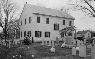
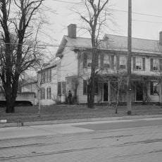
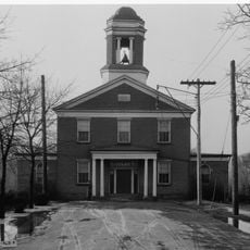
Forty Fort Meetinghouse, historic church in Pennsylvania, United States

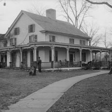
The Forty Fort Meetinghouse is a wooden religious building with white clapboard siding built around 1807 in New England style, located on cemetery grounds. The structure has maintained its original form and features a simple interior with a handcrafted pine ceiling and original double doors.

The building was completed in 1807 after European settlers from Connecticut arrived in the 1760s, though early wars delayed construction projects in the area. It served as the region's first church for worship until both denominations built their own separate buildings by 1837.

The meetinghouse was originally shared by Congregationalists and Methodists before each group established separate churches around 1837. Its simple interior with handcrafted details reflects the practical communal use that defined early settlement life in the region.

The building sits on the Forty Fort Cemetery grounds, positioned away from busy streets and easy to access on foot. Guided tours run from spring through early fall and explain how the structure was built and its role in early community life.

The building was accidentally well preserved because early neglect prevented the kinds of changes that affected many other historic structures. Despite a 1972 flood that damaged surrounding cemetery areas, the structure itself remained unharmed.

The community of curious travelers

AroundUs brings together thousands of curated places, local tips, and hidden gems, enriched daily by 60,000 contributors worldwide.

Start exploring
Location
GPS coordinates
41.28444,-75.87167
Latest update
February 9, 2026 07:43
Around this place
Mohegan Sun Arena at Casey Plaza
United States of America

Mohegan Sun Arena at Casey Plaza

5.3 km
Frances Slocum State Park
United States of America

Frances Slocum State Park

6.4 km
Seven Tubs Natural Area
United States of America

Seven Tubs Natural Area

7.3 km
F.M. Kirby Center for the Performing Arts
United States of America

F.M. Kirby Center for the Performing Arts

4.5 km
Luzerne County Courthouse
United States of America

Luzerne County Courthouse

3.7 km
Wyoming Monument
United States of America

Wyoming Monument

3.2 km
Ashley Planes
United States of America

Ashley Planes

10.9 km
Campbell's Ledge
United States of America

Campbell's Ledge

10.5 km
Pennsylvania Anthracite Heritage Museum
United States of America

Pennsylvania Anthracite Heritage Museum

19.5 km
Market Street Bridge
United States of America

Market Street Bridge

4.2 km
Denison House
United States of America

Denison House

1.8 km
River Street Historic District
United States of America

River Street Historic District

4.3 km
St. Stanislaus Institute
United States of America

St. Stanislaus Institute

16 km
St. Stephen's Episcopal Pro-Cathedral
United States of America

St. Stephen's Episcopal Pro-Cathedral

4.3 km
Swetland Homestead
United States of America

Swetland Homestead

2.5 km
Nesbitt Reservoir
United States of America

Nesbitt Reservoir

18.9 km
Firefighters' Memorial Bridge
United States of America

Firefighters' Memorial Bridge

7.9 km
St. John the Evangelist Roman Catholic Church and School Building
United States of America

St. John the Evangelist Roman Catholic Church and School Building

3 km
Bear Creek Village Historic District
United States of America

Bear Creek Village Historic District

14.9 km
Laurel Run
United States of America

Laurel Run

2.9 km
Bridge in City of Wilkes-Barre
United States of America

Bridge in City of Wilkes-Barre

2.7 km
West End Wheelmen's Club
United States of America

West End Wheelmen's Club

5.4 km
Weiss Hall
United States of America

Weiss Hall

4.4 km
Luzerne Presbyterial Institute
United States of America

Luzerne Presbyterial Institute

3.9 km
McClintock Hall
United States of America

McClintock Hall

4.2 km
Luzerne County Fresh Air Camp
United States of America

Luzerne County Fresh Air Camp

16 km
Catlin Hall
United States of America

Catlin Hall

4.4 km
Forty Fort Theater
United States of America

Forty Fort Theater

427 m
Show the full map
« Forty Fort Meetinghouse - historic church in Pennsylvania, United States » is provided by Around Us (aroundus.com). Images and texts are derived from Wikimedia project under a Creative Commons license. You are allowed to copy, distribute, and modify copies of this page, under the conditions set by the license, as long as this note is clearly visible.

Discover hidden gems everywhere you go!

From secret cafés to breathtaking viewpoints, skip the crowded tourist spots and find places that match your style. Our app makes it easy with voice search, smart filtering, route optimization, and insider tips from travelers worldwide. Download now for the complete mobile experience.

Around Us App Screenshot

A unique approach to discovering new places

Le Figaro

All the places worth exploring

France Info

A tailor-made excursion in just a few clicks

20 Minutes

Around Us
Travel Guide & Maps
Download

Send to your phone

QR Code
1

Open the camera app on your mobile.

2

Point at the QR code with your camera. A notification will appear.

3

Tap the notification to open the link.