Enable Location

We need your location to show you interesting places around you

Discover nearby places

Find interesting locations and hidden gems around you

Precise directions

Get accurate directions and distances to places

Your location is never shared with other users. It's only used when you tap the location button.

Ashley Planes

Log in to your account

Start exploring — it's free

Trusted by 63,323 travelers worldwide

Continue with Google
Continue with Apple
or

We will send you a code to connect

By continuing, you accept our Terms and Conditions and our Privacy Policy

Check your inbox

We've sent a pincode in your inbox. Please enter the code below.

Discussion Reviews 1 Photos
3.1k Popularity

Ashley Planes, Cable railway system in Pennsylvania, United States

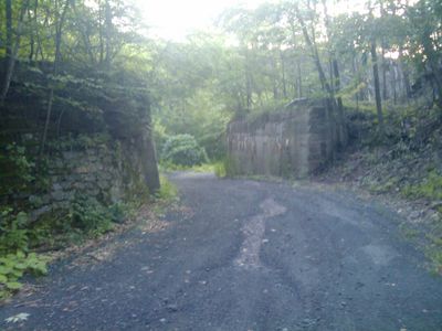
Ashley Planes was a cable railway system consisting of three separate inclined sections that transported rail cars over Wilkes-Barre Mountain using cable mechanisms and stationary engines. The installation connected the Wyoming Valley with nearby distribution points and created a vital transportation route for raw materials.

The system was built in 1837 by the Lehigh Coal & Navigation Company to connect coal-rich valleys with ports to the east. This infrastructure played a key role in early American industrial development and made regional resources accessible across the nation.

The site represented industrial achievement in the region and showed how engineering innovations transformed coal extraction. Workers and local communities viewed this infrastructure as a symbol of progress that reshaped their area.

Visitors should know the area is hilly and features well-trafficked walking paths through the landscape. The best times to explore are spring and fall, when the weather is mild and views of the mountain terrain remain clear.

The system used a clever counterweight design where empty cars traveled downhill and automatically pulled loaded cars uphill. This elegant mechanical solution required less power than conventional drives and was a remarkable engineering achievement for its time.

The community of curious travelers

AroundUs brings together thousands of curated places, local tips, and hidden gems, enriched daily by 60,000 contributors worldwide.

Start exploring
Location
Inception
1837
GPS coordinates
41.19060,-75.91030
Latest update
December 12, 2025 12:00
Around this place
Mohegan Sun Arena at Casey Plaza
United States of America

Mohegan Sun Arena at Casey Plaza

7.6 km
Frances Slocum State Park
United States of America

Frances Slocum State Park

16.7 km
Seven Tubs Natural Area
United States of America

Seven Tubs Natural Area

9.5 km
F.M. Kirby Center for the Performing Arts
United States of America

F.M. Kirby Center for the Performing Arts

6.5 km
Nescopeck State Park
United States of America

Nescopeck State Park

12.7 km
Luzerne County Courthouse
United States of America

Luzerne County Courthouse

7.2 km
Wyoming Monument
United States of America

Wyoming Monument

13.9 km
Campbell's Ledge
United States of America

Campbell's Ledge

21.1 km
Market Street Bridge
United States of America

Market Street Bridge

6.8 km
Denison House
United States of America

Denison House

12.7 km
River Street Historic District
United States of America

River Street Historic District

6.6 km
St. Stanislaus Institute
United States of America

St. Stanislaus Institute

9 km
St. Stephen's Episcopal Pro-Cathedral
United States of America

St. Stephen's Episcopal Pro-Cathedral

6.6 km
Swetland Homestead
United States of America

Swetland Homestead

13.3 km
Firefighters' Memorial Bridge
United States of America

Firefighters' Memorial Bridge

17.8 km
Forty Fort Meetinghouse
United States of America

Forty Fort Meetinghouse

10.9 km
St. John the Evangelist Roman Catholic Church and School Building
United States of America

St. John the Evangelist Roman Catholic Church and School Building

8.3 km
Bear Creek Village Historic District
United States of America

Bear Creek Village Historic District

13 km
Laurel Run
United States of America

Laurel Run

9.1 km
Bridge in City of Wilkes-Barre
United States of America

Bridge in City of Wilkes-Barre

8.5 km
West End Wheelmen's Club
United States of America

West End Wheelmen's Club

5.6 km
Weiss Hall
United States of America

Weiss Hall

6.5 km
George W. Search House
United States of America

George W. Search House

20.7 km
Luzerne Presbyterial Institute
United States of America

Luzerne Presbyterial Institute

14.6 km
McClintock Hall
United States of America

McClintock Hall

6.7 km
Luzerne County Fresh Air Camp
United States of America

Luzerne County Fresh Air Camp

9 km
Catlin Hall
United States of America

Catlin Hall

6.6 km
Forty Fort Theater
United States of America

Forty Fort Theater

11.4 km
Show the full map
Reviews
Share your experience

No review yet

Discussions
Start a discussion...

No discussion yet

« Ashley Planes - Cable railway system in Pennsylvania, United States » is provided by Around Us (aroundus.com). Images and texts are derived from Wikimedia project under a Creative Commons license. You are allowed to copy, distribute, and modify copies of this page, under the conditions set by the license, as long as this note is clearly visible.

Discover hidden gems everywhere you go!

From secret cafés to breathtaking viewpoints, skip the crowded tourist spots and find places that match your style. Our app makes it easy with voice search, smart filtering, route optimization, and insider tips from travelers worldwide. Download now for the complete mobile experience.

Around Us App Screenshot

A unique approach to discovering new places

Le Figaro

All the places worth exploring

France Info

A tailor-made excursion in just a few clicks

20 Minutes

Around Us
Travel Guide & Maps
Download

Send to your phone

QR Code
1

Open the camera app on your mobile.

2

Point at the QR code with your camera. A notification will appear.

3

Tap the notification to open the link.