Enable Location

We need your location to show you interesting places around you

Discover nearby places

Find interesting locations and hidden gems around you

Precise directions

Get accurate directions and distances to places

Your location is never shared with other users. It's only used when you tap the location button.

Greens Farms School

Log in to your account

Start exploring — it's free

Trusted by 62,558 travelers worldwide

Continue with Google
Continue with Apple
or

We will send you a code to connect

By continuing, you accept our Terms and Conditions and our Privacy Policy

Check your inbox

We've sent a pincode in your inbox. Please enter the code below.

Greens Farms School, Schule in den Vereinigten Staaten

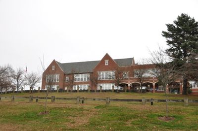
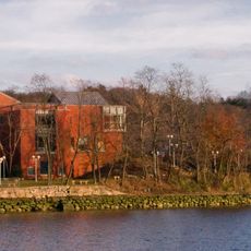
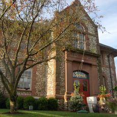
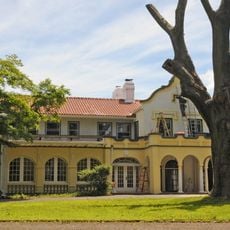
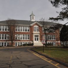
Greens Farms School is a school building completed in 1925 in Westport, Connecticut, located at the corner of Morningside Drive South and Post Road East. The structure was designed by architect Charles Cutler in Tudor Revival style, featuring distinctive brick walls and steep roofs, with an addition built in 1950 to expand classroom space.

The building opened in 1925 and expanded in 1950 to serve more students. It closed in 1983 due to declining enrollment, served as an arts center, then reopened in 1997 after major renovation and remains a public elementary school today.

The school has served different community roles over time, first as a learning space for local children and later as a studio for artists. Today it represents the town's ongoing effort to balance education and cultural activities in a single historic structure.

The school sits at a central location in Westport and is accessible from main roads. Be aware that the steep driveway can be challenging in winter weather, and the building does not meet all current accessibility standards for visitors with mobility needs.

The building contains artwork created around 1935 as part of a Depression-era work program. This is a rarely noticed piece of history that connects the site to a pivotal moment in American economic and cultural life.

The community of curious travelers

AroundUs brings together thousands of curated places, local tips, and hidden gems, enriched daily by 60,000 contributors worldwide.

Start exploring
Location
GPS coordinates
41.13694,-73.32528
Latest update
February 9, 2026 08:19
Around this place
Sherwood Island State Park
United States of America

Sherwood Island State Park

2.4 km
Westport Country Playhouse
United States of America

Westport Country Playhouse

2.5 km
Pequot Library
United States of America

Pequot Library

3.1 km
Earthplace
United States of America

Earthplace

4.8 km
Jonathan Sturges House
United States of America

Jonathan Sturges House

5 km
Saugatuck River Bridge
United States of America

Saugatuck River Bridge

4 km
Louis Micheels House
United States of America

Louis Micheels House

3.5 km
David Ogden House
United States of America

David Ogden House

4.7 km
Saugatuck River Railroad Bridge
United States of America

Saugatuck River Railroad Bridge

4.1 km
Southport Historic District
United States of America

Southport Historic District

3.5 km
Bronson Windmill
United States of America

Bronson Windmill

4.9 km
Westport Public Library
United States of America

Westport Public Library

3.1 km
Compo–Owenoke Historic District
United States of America

Compo–Owenoke Historic District

4.2 km
United States of America

Westport Observatory

3.8 km
Our Lady of the Assumption Church
United States of America

Our Lady of the Assumption Church

3.3 km
Greenfield Hill Historic District
United States of America

Greenfield Hill Historic District

5 km
Godillot Place
United States of America

Godillot Place

2.9 km
Town Hall
United States of America

Town Hall

3 km
The Allen House
United States of America

The Allen House

4.8 km
Westport Bank and Trust Company
United States of America

Westport Bank and Trust Company

3.1 km
Mill Cove Historic District
United States of America

Mill Cove Historic District

3 km
Restmore
United States of America

Restmore

4.3 km
Kings Highway North Historic District
United States of America

Kings Highway North Historic District

3.6 km
Bradley-Wheeler House
United States of America

Bradley-Wheeler House

3.1 km
National Hall Historic District
United States of America

National Hall Historic District

3.4 km
Shambaugh House
United States of America

Shambaugh House

3.8 km
Bridge Street Historic District
United States of America

Bridge Street Historic District

3.6 km
John Osborne House
United States of America

John Osborne House

4.7 km
Show the full map
« Greens Farms School - Schule in den Vereinigten Staaten » is provided by Around Us (aroundus.com). Images and texts are derived from Wikimedia project under a Creative Commons license. You are allowed to copy, distribute, and modify copies of this page, under the conditions set by the license, as long as this note is clearly visible.

Discover hidden gems everywhere you go!

From secret cafés to breathtaking viewpoints, skip the crowded tourist spots and find places that match your style. Our app makes it easy with voice search, smart filtering, route optimization, and insider tips from travelers worldwide. Download now for the complete mobile experience.

Around Us App Screenshot

A unique approach to discovering new places

Le Figaro

All the places worth exploring

France Info

A tailor-made excursion in just a few clicks

20 Minutes

Around Us
Travel Guide & Maps
Download

Send to your phone

QR Code
1

Open the camera app on your mobile.

2

Point at the QR code with your camera. A notification will appear.

3

Tap the notification to open the link.