Enable Location

We need your location to show you interesting places around you

Discover nearby places

Find interesting locations and hidden gems around you

Precise directions

Get accurate directions and distances to places

Your location is never shared with other users. It's only used when you tap the location button.

Lake Wyola State Park

Log in to your account

Start exploring — it's free

Trusted by 61,421 travelers worldwide

Continue with Google
Continue with Apple
or

We will send you a code to connect

By continuing, you accept our Terms and Conditions and our Privacy Policy

Check your inbox

We've sent a pincode in your inbox. Please enter the code below.

Lake Wyola State Park

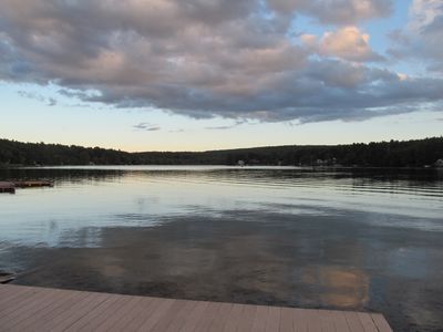
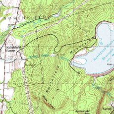
Lake Wyola State Park, State park in Shutesbury, Massachusetts, United States.

Description

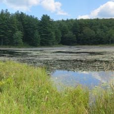
Lake Wyola State Park is a recreation area along Lake Wyola's shoreline featuring woodland trails and a swimming beach. The property spans approximately 40 acres and supports a range of outdoor pursuits including fishing and boating.

History

The state acquired this land in 1997 and opened it as a public recreation area for the surrounding community. The expansion of public access transformed what was previously private property into shared outdoor space.

Culture

The park bears the name Carroll A. Holmes Recreation Area, honoring a former Shutesbury selectman who served as director within the Department of Environmental Management.

Practical

The main entrance provides access to swimming, fishing, and boating with a public boat launch available. Plan your visit considering seasonal conditions, as facilities and trail usage vary throughout the year.

Did you know?

During winter months, designated trails support cross-country skiing and snowmobiling activities. This year-round adaptability makes the park useful for different outdoor pursuits depending on the season.

Location
Inception
1997
GPS coordinates
42.50220,-72.43610
Latest update
December 12, 2025 12:01

AroundUs brings together thousands of curated places, local tips, and hidden gems, enriched daily by 60,000 contributors worldwide. Discover all places nearby (Massachusetts).

Around this place
Metacomet-Monadnock Trail
United States of America

Metacomet-Monadnock Trail

5.4 km
French King Bridge
United States of America

French King Bridge

11.7 km
Buttonball Tree
United States of America

Buttonball Tree

12.3 km
Sugarloaf Mountain
United States of America

Sugarloaf Mountain

13.3 km
Mount Toby
United States of America

Mount Toby

8.5 km
Bear's Den
United States of America

Bear's Den

10.1 km
Mount Sugarloaf State Reservation
United States of America

Mount Sugarloaf State Reservation

13.3 km
Northfield Mountain
United States of America

Northfield Mountain

12.8 km
United States of America

New England Peace Pagoda

4.5 km
Wendell State Forest
United States of America

Wendell State Forest

5.5 km
Sunderland Bridge
United States of America

Sunderland Bridge

12.8 km
United States of America

Mount Orient

12.3 km
Rattlesnake Gutter
United States of America

Rattlesnake Gutter

5.9 km
Pocumtuck Ridge Trail
United States of America

Pocumtuck Ridge Trail

13 km
Whitaker-Clary House
United States of America

Whitaker-Clary House

10.7 km
Springfield Terminal railroad bridge, Deerfield
United States of America

Springfield Terminal railroad bridge, Deerfield

11.9 km
Moore's Corner Historic District
United States of America

Moore's Corner Historic District

2.8 km
Pelham Town Hall Historic District
United States of America

Pelham Town Hall Historic District

12.5 km
Cushman Village Historic District
United States of America

Cushman Village Historic District

11.1 km
North Amherst Center Historic District
United States of America

North Amherst Center Historic District

13 km
New Salem Common Historic District
United States of America

New Salem Common Historic District

8.6 km
North Leverett, Massachusetts
United States of America

North Leverett, Massachusetts

4.6 km
Wendell Town Common Historic District
United States of America

Wendell Town Common Historic District

6.1 km
East Leverett Historic District
United States of America

East Leverett Historic District

8.1 km
Robert Frost Trail
United States of America

Robert Frost Trail

8.5 km
Leverett Center Historic District
United States of America

Leverett Center Historic District

7.2 km
Montague Center Historic District
United States of America

Montague Center Historic District

8.9 km
Mount Toby Fire Tower
United States of America

Mount Toby Fire Tower

8.5 km
Show the full map
« Lake Wyola State Park - State park in Shutesbury, Massachusetts, United States » is provided by Around Us (aroundus.com). Images and texts are derived from Wikimedia project under a Creative Commons license. You are allowed to copy, distribute, and modify copies of this page, under the conditions set by the license, as long as this note is clearly visible.

Discover hidden gems everywhere you go!

From secret cafés to breathtaking viewpoints, skip the crowded tourist spots and find places that match your style. Our app makes it easy with voice search, smart filtering, route optimization, and insider tips from travelers worldwide. Download now for the complete mobile experience.

Around Us App Screenshot

A unique approach to discovering new places

Le Figaro

All the places worth exploring

France Info

A tailor-made excursion in just a few clicks

20 Minutes

Around Us
Travel Guide & Maps
Download

Send to your phone

QR Code
1

Open the camera app on your mobile.

2

Point at the QR code with your camera. A notification will appear.

3

Tap the notification to open the link.