Enable Location

We need your location to show you interesting places around you

Discover nearby places

Find interesting locations and hidden gems around you

Precise directions

Get accurate directions and distances to places

Your location is never shared with other users. It's only used when you tap the location button.

Log in to your account

Start exploring — it's free

Trusted by 68,261 travelers worldwide

Continue with Google
Continue with Apple
or

We will send you a code to connect

By continuing, you accept our Terms and Conditions and our Privacy Policy

Check your inbox

We've sent a pincode in your inbox. Please enter the code below.

Shawnee Hills
Discussion Reviews Photo
15.1k Popularity

Shawnee Hills, Geological formation in southern Illinois, United States

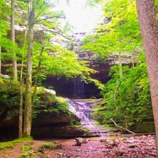
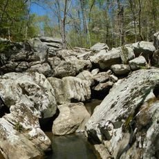
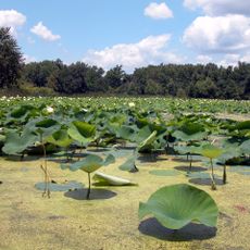
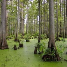
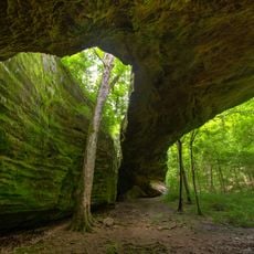
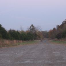
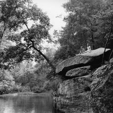
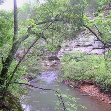
The Shawnee Hills are a curved geological formation stretching across southern Illinois, composed of limestone and sandstone layers that rise above the surrounding terrain. The formation features steep bluffs, deep ravines, and waterfalls that create a landscape distinctly different from the flat plains elsewhere in the state.

The Shawnee Hills formed millions of years ago when ancient seas covered this region and left behind sedimentary layers. The area became known for mineral extraction, particularly fluorite mining near Rosiclare and Cave in Rock that supplied global markets for decades.

These hills have long served as a place where people come to hike, camp, and connect with the outdoors in southern Illinois. The landscape shapes how visitors experience this region and defines its role as a natural retreat.

Visitors can explore hiking trails throughout the area, which spans multiple counties and is managed by the U.S. Forest Service. Camping and picnic facilities are available at various accessible points that serve as good starting locations for exploring the terrain.

The hills escaped glaciation during ice ages that flattened much of Illinois, which explains why ancient rock formations and structural patterns remain so well preserved here. This absence of glacial activity makes it a rare geological window into a landscape that existed long before the ice ages shaped the rest of the state.

The community of curious travelers

AroundUs brings together thousands of curated places, local tips, and hidden gems, enriched daily by 60,000 contributors worldwide.

Start exploring
Location
GPS coordinates
37.50000,-88.66670
Latest update
December 7, 2025 19:31
Around this place
Garden of the Gods Wilderness
United States of America

Garden of the Gods Wilderness

26.8 km
Ferne Clyffe State Park
United States of America

Ferne Clyffe State Park

28.1 km
Dixon Springs State Park
United States of America

Dixon Springs State Park

13.1 km
Williamson County Jail
United States of America

Williamson County Jail

34.5 km
Cache River State Natural Area
United States of America

Cache River State Natural Area

29.8 km
United States of America

Tolu Site

37.3 km
Illinois Iron Furnace
United States of America

Illinois Iron Furnace

29.9 km
Mermet Lake State Fish and Wildlife Area
United States of America

Mermet Lake State Fish and Wildlife Area

31.1 km
Heron Pond – Little Black Slough Nature Preserve
United States of America

Heron Pond – Little Black Slough Nature Preserve

29.1 km
Mantle Rock Archeological District
United States of America

Mantle Rock Archeological District

26.7 km
Orr-Herl Mound and Village Site
United States of America

Orr-Herl Mound and Village Site

30.8 km
Vienna Public Library
United States of America

Vienna Public Library

22.2 km
Carrier Mills Archaeological District
United States of America

Carrier Mills Archaeological District

18.1 km
Golconda Historic District
United States of America

Golconda Historic District

21.8 km
United States of America

Lusk's Ferry, Illinois

22 km
Saline County Poor Farm
United States of America

Saline County Poor Farm

26.4 km
Bell Smith Springs
United States of America

Bell Smith Springs

2.3 km
Willis Allen House
United States of America

Willis Allen House

34.1 km
Lusk Creek Canyon
United States of America

Lusk Creek Canyon

11.4 km
John Bridges Tavern and Store Site
United States of America

John Bridges Tavern and Store Site

31.6 km
Johnson County Courthouse
United States of America

Johnson County Courthouse

22.4 km
Saline County Courthouse
United States of America

Saline County Courthouse

28.8 km
Goddard Chapel
United States of America

Goddard Chapel

35.7 km
Hardin County Courthouse
United States of America

Hardin County Courthouse

32.5 km
Williamson County Courthouse
United States of America

Williamson County Courthouse

34.7 km
Harrisburg City Hall
United States of America

Harrisburg City Hall

28.9 km
Ed M. Stotlar House
United States of America

Ed M. Stotlar House

35.4 km
Ross Cottom Lanes
United States of America

Ross Cottom Lanes

32.2 km
Show the full map
Reviews
Share your experience

No review yet

Discussions
Start a discussion...

No discussion yet

« Shawnee Hills - Geological formation in southern Illinois, United States » is provided by Around Us (aroundus.com). Images and texts are derived from Wikimedia project under a Creative Commons license. You are allowed to copy, distribute, and modify copies of this page, under the conditions set by the license, as long as this note is clearly visible.

Discover hidden gems everywhere you go!

From secret cafés to breathtaking viewpoints, skip the crowded tourist spots and find places that match your style. Our app makes it easy with voice search, smart filtering, route optimization, and insider tips from travelers worldwide. Download now for the complete mobile experience.

Around Us App Screenshot

A unique approach to discovering new places

Le Figaro

All the places worth exploring

France Info

A tailor-made excursion in just a few clicks

20 Minutes

Around Us
Travel Guide & Maps
Download

Send to your phone

QR Code
1

Open the camera app on your mobile.

2

Point at the QR code with your camera. A notification will appear.

3

Tap the notification to open the link.