Chest opened
+${chestReward.xp} XP
Explorer
NOUVEAU ×${chestReward.collectible.quantity}
tapez pour fermer
Chest locked

Open chests in the app

Around Us is built for your phone — chests unlock when you walk, explore and capture nearby places.

Enable Location

We need your location to show you interesting places around you

Discover nearby places

Find interesting locations and hidden gems around you

Precise directions

Get accurate directions and distances to places

Your location is never shared with other users. It's only used when you tap the location button.

Log in to your account

Start exploring — it's free

Trusted by 72,937 travelers worldwide

Continue with Google
Continue with Apple
or

We will send you a code to connect

By continuing, you accept our Terms and Conditions and our Privacy Policy

Check your inbox

We've sent a pincode in your inbox. Please enter the code below.

Discussion Reviews Photo
1.4k Popularity

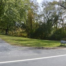
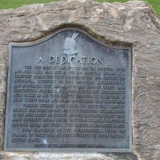
Shenks Ferry Site, Archaeological site in Martic Township, Pennsylvania.

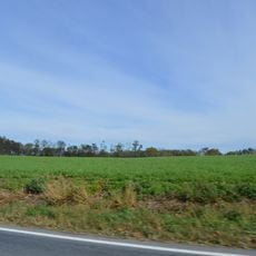
Shenks Ferry Site is an archaeological location in Martic Township that covers roughly 4.6 acres along Grubbs Creek and contains the remains of villages and seasonal camps from an earlier period. The ground shows multiple layers of settlement that allow researchers to study different periods of human activity and occupation patterns.

The location was home to people between 1300 and a later period when they established villages and camps before the area was abandoned. Researchers conducted excavations in the 1930s and again in the 1970s to uncover and study the history of this place.

Pottery fragments, animal bones, and stone tools scattered here reveal how people spent their daily lives through crafting, hunting, and gathering activities. The distribution of these items across the site tells stories about the ways they organized their work and routines.

The grounds sit away from main roads and are best reached on foot, with sturdy shoes recommended since the terrain can be uneven in places. Visitors should plan ahead since the area has few services nearby and it is wise to bring water and sun protection for the walk.

Studies of waste heaps reveal that residents followed a varied diet mixing meat from deer with crops they cultivated and nuts they gathered nearby. This combination shows how resourcefully they used both hunting and farming strategies to feed their community.

The community of curious travelers

AroundUs brings together thousands of curated places, local tips, and hidden gems, enriched daily by 60,000 contributors worldwide.

Start exploring
Location
GPS coordinates
39.90500,-76.36020
Latest update
December 14, 2025 16:44
Around this place
Safe Harbor Dam
United States of America

Safe Harbor Dam

3.3 km
Woodward Hill Cemetery
United States of America

Woodward Hill Cemetery

14.4 km
Hans Herr House
United States of America

Hans Herr House

11.9 km
Susquehannock State Park
United States of America

Susquehannock State Park

11.9 km
Conestoga Town
United States of America

Conestoga Town

7 km
Norman Wood Bridge
United States of America

Norman Wood Bridge

10.2 km
Baumgardener's Covered Bridge
United States of America

Baumgardener's Covered Bridge

6.3 km
Rock Ford Plantation
United States of America

Rock Ford Plantation

14.2 km
Safe Harbor Bridge
United States of America

Safe Harbor Bridge

3.1 km
Colemanville Covered Bridge
United States of America

Colemanville Covered Bridge

1.7 km
Lime Valley Covered Bridge
United States of America

Lime Valley Covered Bridge

12.4 km
Indian Steps Cabin
United States of America

Indian Steps Cabin

4.8 km
Neff's Mill Covered Bridge
United States of America

Neff's Mill Covered Bridge

14.1 km
Dritt Mansion
United States of America

Dritt Mansion

14.2 km
McCalls Ferry Farm
United States of America

McCalls Ferry Farm

8.9 km
Lancaster Crematorium
United States of America

Lancaster Crematorium

14.5 km
Duncan Island
United States of America

Duncan Island

4.9 km
Holtwood Environmental Preserve
United States of America

Holtwood Environmental Preserve

8.7 km
Guinston United Presbyterian Church
United States of America

Guinston United Presbyterian Church

13.7 km
Bausman Farmstead
United States of America

Bausman Farmstead

13.2 km
Johannes Harnish Farmstead
United States of America

Johannes Harnish Farmstead

12.4 km
Byrd Leibhart Site
United States of America

Byrd Leibhart Site

14.3 km
Strickler Site
United States of America

Strickler Site

12 km
Frey-Haverstick Site
United States of America

Frey-Haverstick Site

13.7 km
Murry Site
United States of America

Murry Site

11.4 km
Shultz-Funk Site
United States of America

Shultz-Funk Site

10.7 km
Park Site (36LA96)
United States of America

Park Site (36LA96)

14.2 km
Historic Rock Ford Plantation
United States of America

Historic Rock Ford Plantation

14.2 km
Show the full map
Reviews
Share your experience

No review yet

Discussions
Start a discussion...

No discussion yet

« Shenks Ferry Site - Archaeological site in Martic Township, Pennsylvania » is provided by Around Us (aroundus.com). Images and texts are derived from Wikimedia project under a Creative Commons license. You are allowed to copy, distribute, and modify copies of this page, under the conditions set by the license, as long as this note is clearly visible.

Discover hidden gems everywhere you go!

From secret cafés to breathtaking viewpoints, skip the crowded tourist spots and find places that match your style. Our app makes it easy with voice search, smart filtering, route optimization, and insider tips from travelers worldwide. Download now for the complete mobile experience.

Around Us App Screenshot

A unique approach to discovering new places

Le Figaro

All the places worth exploring

France Info

A tailor-made excursion in just a few clicks

20 Minutes

Around Us
Travel Guide & Maps
Download

Send to your phone

QR Code
1

Open the camera app on your mobile.

2

Point at the QR code with your camera. A notification will appear.

3

Tap the notification to open the link.