Enable Location

We need your location to show you interesting places around you

Discover nearby places

Find interesting locations and hidden gems around you

Precise directions

Get accurate directions and distances to places

Your location is never shared with other users. It's only used when you tap the location button.

United States Post Office

Log in to your account

Start exploring — it's free

Trusted by 62,430 travelers worldwide

Continue with Google
Continue with Apple
or

We will send you a code to connect

By continuing, you accept our Terms and Conditions and our Privacy Policy

Check your inbox

We've sent a pincode in your inbox. Please enter the code below.

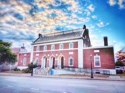
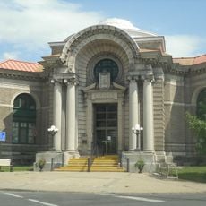
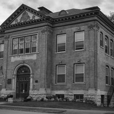
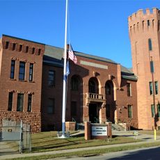
United States Post Office, government building in Montgomery County, New York

The United States Post Office in New York is a solid, functional building with brick walls and large windows that blends into the streetscape. Inside, wide counters are arranged for sorting and handling mail, with bright lighting and a clear layout that allows visitors to complete their tasks quickly and easily.

The post office is rooted in New York's postal history, which connected the city with distant areas starting in the 1700s and kept people linked across great distances. The building has endured decades of urban changes and technological advances while remaining true to its original purpose.

The post office served as a gathering place where neighbors connected and shared news over many decades. It represents how communication and community bonds remained central to the city's daily life, turning a simple building into a hub where people recognized each other and maintained their ties.

The building is easy to spot and located in a central area with good pedestrian access. Visitors should expect the interior to be busy and full of activity during operating hours, especially during morning and midday rush times.

The earliest post office in Lower Manhattan was once a church building and was the place where America's first postage stamps were sold. This detail shows how New York played a central role in shaping the country's modern postal system.

The community of curious travelers

AroundUs brings together thousands of curated places, local tips, and hidden gems, enriched daily by 60,000 contributors worldwide.

Start exploring
Location
GPS coordinates
42.93722,-74.19194
Latest update
February 9, 2026 07:47
Around this place
Schoharie Creek Bridge collapse
United States of America

Schoharie Creek Bridge collapse

7.1 km
National Shrine of the North American Martyrs
United States of America

National Shrine of the North American Martyrs

9.1 km
Plotter Kill Preserve
United States of America

Plotter Kill Preserve

17.4 km
Caughnawaga Indian Village Site
United States of America

Caughnawaga Indian Village Site

16.5 km
Schoharie Crossing State Historic Site
United States of America

Schoharie Crossing State Historic Site

7.7 km
Mabee House
United States of America

Mabee House

15.3 km
Old Fort Johnson
United States of America

Old Fort Johnson

4.6 km
Tryon County Jail
United States of America

Tryon County Jail

16.3 km
Guy Park
United States of America

Guy Park

1.8 km
Knox Mansion
United States of America

Knox Mansion

16.5 km
Greene Mansion
United States of America

Greene Mansion

322 m
Amsterdam City Hall
United States of America

Amsterdam City Hall

5.8 km
Saint Stanislaus Roman Catholic Church Complex
United States of America

Saint Stanislaus Roman Catholic Church Complex

1.1 km
Mohawk Valley Gateway Overlook pedestrian bridge
United States of America

Mohawk Valley Gateway Overlook pedestrian bridge

288 m
Gloversville Free Library
United States of America

Gloversville Free Library

17.6 km
Chalmers Knitting Mills
United States of America

Chalmers Knitting Mills

422 m
Fulton County Courthouse
United States of America

Fulton County Courthouse

16.8 km
Log Cabin Church
United States of America

Log Cabin Church

14.3 km
Guy Park Avenue School
United States of America

Guy Park Avenue School

1.9 km
West Charlton United Presbyterian Church
United States of America

West Charlton United Presbyterian Church

13.7 km
Temple of Israel
United States of America

Temple of Israel

335 m
Gray-Jewett House
United States of America

Gray-Jewett House

770 m
Gloversville Armory
United States of America

Gloversville Armory

17.4 km
First Baptist Church
United States of America

First Baptist Church

15.9 km
Gustav Levor House
United States of America

Gustav Levor House

17.8 km
Vrooman Avenue School
United States of America

Vrooman Avenue School

1.4 km
Mariaville Historic District
United States of America

Mariaville Historic District

13 km
Glen Historic District
United States of America

Glen Historic District

13.2 km
Show the full map
« United States Post Office - government building in Montgomery County, New York » is provided by Around Us (aroundus.com). Images and texts are derived from Wikimedia project under a Creative Commons license. You are allowed to copy, distribute, and modify copies of this page, under the conditions set by the license, as long as this note is clearly visible.

Discover hidden gems everywhere you go!

From secret cafés to breathtaking viewpoints, skip the crowded tourist spots and find places that match your style. Our app makes it easy with voice search, smart filtering, route optimization, and insider tips from travelers worldwide. Download now for the complete mobile experience.

Around Us App Screenshot

A unique approach to discovering new places

Le Figaro

All the places worth exploring

France Info

A tailor-made excursion in just a few clicks

20 Minutes

Around Us
Travel Guide & Maps
Download

Send to your phone

QR Code
1

Open the camera app on your mobile.

2

Point at the QR code with your camera. A notification will appear.

3

Tap the notification to open the link.