Chest opened
+${chestReward.xp} XP
Explorer
NOUVEAU ×${chestReward.collectible.quantity}
tapez pour fermer
Chest locked

Open chests in the app

Around Us is built for your phone — chests unlock when you walk, explore and capture nearby places.

Enable Location

We need your location to show you interesting places around you

Discover nearby places

Find interesting locations and hidden gems around you

Precise directions

Get accurate directions and distances to places

Your location is never shared with other users. It's only used when you tap the location button.

Log in to your account

Start exploring — it's free

Trusted by 73,052 travelers worldwide

Continue with Google
Continue with Apple
or

We will send you a code to connect

By continuing, you accept our Terms and Conditions and our Privacy Policy

Check your inbox

We've sent a pincode in your inbox. Please enter the code below.

Peabody River State Fish and Wildlife Area
Discussion Reviews Photo
1.8k Popularity

Peabody River State Fish and Wildlife Area, Wildlife conservation area in Randolph County, Illinois.

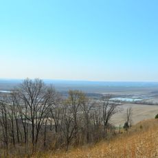
Peabody River State Fish and Wildlife Area is a protected reserve in Randolph County containing multiple lakes and ponds that developed from former mining sites. These water bodies provide habitats for various fish species and serve as destinations for fishing activities.

The land was shaped by decades of coal mining operations that transformed the landscape. Conversion into a protected area began in the 1990s when the state acquired former mining grounds from the coal company.

The area maintains designated spaces for waterfowl migration, supporting populations of Canada geese, wood ducks, mallards, and blue-winged teal.

The area is open for various outdoor activities, though specific permits may be required for certain waters. Visitors should check restrictions in advance, as not all areas are accessible with all boat types.

The site was rehabilitated after mining by strategically planting crops such as sunflowers and grains to support wildlife. This approach demonstrates how abandoned industrial landscapes can be transformed into thriving ecological spaces.

The community of curious travelers

AroundUs brings together thousands of curated places, local tips, and hidden gems, enriched daily by 60,000 contributors worldwide.

Start exploring
Location
GPS coordinates
38.21750,-89.86920
Latest update
December 14, 2025 11:42
Around this place
Fort de Chartres
United States of America

Fort de Chartres

29.3 km
Illinois Caverns State Natural Area
United States of America

Illinois Caverns State Natural Area

23.5 km
Fort Kaskaskia State Historic Site
United States of America

Fort Kaskaskia State Historic Site

27.9 km
Louis Bolduc House
United States of America

Louis Bolduc House

30.6 km
Felix Vallé House State Historic Site
United States of America

Felix Vallé House State Historic Site

30.6 km
Modoc Rock Shelter
United States of America

Modoc Rock Shelter

24.2 km
Pierre Menard House
United States of America

Pierre Menard House

28.4 km
Ste. Genevieve Historic District
United States of America

Ste. Genevieve Historic District

30.5 km
French Colonial Historic District
United States of America

French Colonial Historic District

27.5 km
Amoureux House
United States of America

Amoureux House

31 km
Kolmer Site
United States of America

Kolmer Site

30.7 km
Fults Hill Prairie State Natural Area
United States of America

Fults Hill Prairie State Natural Area

27.4 km
Creole House
United States of America

Creole House

24.8 km
Jacques Guibourd Historic House
United States of America

Jacques Guibourd Historic House

30.8 km
Fountain Creek Bridge
United States of America

Fountain Creek Bridge

31 km
Mary's River Covered Bridge
United States of America

Mary's River Covered Bridge

31.3 km
Charter Oak Schoolhouse
United States of America

Charter Oak Schoolhouse

15.7 km
Waterloo Historic District
United States of America

Waterloo Historic District

28 km
Berger-Kiel House
United States of America

Berger-Kiel House

31.9 km
Red Bud Historic District
United States of America

Red Bud Historic District

10.9 km
Sparta Historic District (Sparta, Illinois)
United States of America

Sparta Historic District (Sparta, Illinois)

18.1 km
Marissa Academy
United States of America

Marissa Academy

10.4 km
George Draser, Jr., Houses
United States of America

George Draser, Jr., Houses

30.9 km
Turkey Hill Grange Hall
United States of America

Turkey Hill Grange Hall

29.6 km
Bequette-Ribault House
United States of America

Bequette-Ribault House

31.1 km
Ste. Geneviève National Historical Park
United States of America

Ste. Geneviève National Historical Park

30.6 km
Mascoutah Community Lanes
United States of America

Mascoutah Community Lanes

30.8 km
Jean-Baptiste Vallé House
United States of America

Jean-Baptiste Vallé House

30.6 km
Show the full map
Reviews
Share your experience

No review yet

Discussions
Start a discussion...

No discussion yet

« Peabody River State Fish and Wildlife Area - Wildlife conservation area in Randolph County, Illinois » is provided by Around Us (aroundus.com). Images and texts are derived from Wikimedia project under a Creative Commons license. You are allowed to copy, distribute, and modify copies of this page, under the conditions set by the license, as long as this note is clearly visible.

Discover hidden gems everywhere you go!

From secret cafés to breathtaking viewpoints, skip the crowded tourist spots and find places that match your style. Our app makes it easy with voice search, smart filtering, route optimization, and insider tips from travelers worldwide. Download now for the complete mobile experience.

Around Us App Screenshot

A unique approach to discovering new places

Le Figaro

All the places worth exploring

France Info

A tailor-made excursion in just a few clicks

20 Minutes

Around Us
Travel Guide & Maps
Download

Send to your phone

QR Code
1

Open the camera app on your mobile.

2

Point at the QR code with your camera. A notification will appear.

3

Tap the notification to open the link.