Enable Location

We need your location to show you interesting places around you

Discover nearby places

Find interesting locations and hidden gems around you

Precise directions

Get accurate directions and distances to places

Your location is never shared with other users. It's only used when you tap the location button.

Modoc Rock Shelter

Log in to your account

Start exploring — it's free

Trusted by 66,073 travelers worldwide

Continue with Google
Continue with Apple
or

We will send you a code to connect

By continuing, you accept our Terms and Conditions and our Privacy Policy

Check your inbox

We've sent a pincode in your inbox. Please enter the code below.

Modoc Rock Shelter
Discussion Reviews 1 Photos
3.4k Popularity

Modoc Rock Shelter, Archaeological site near Prairie du Rocher, Illinois, US.

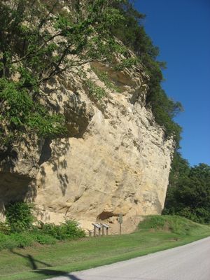
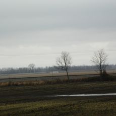
Modoc Rock Shelter is a prehistoric sandstone overhang in southern Illinois, sitting above the Mississippi River floodplain. The ground beneath it holds several sediment layers containing stone tools, projectile points, and bone implements left by earlier inhabitants.

The site was found in 1951 by archaeologist Irvin Peithmann, with evidence of human presence going back roughly 9000 years. Excavations uncovered four separate occupation periods from the Archaic era, each showing a shift in how people hunted and settled.

The rock overhang at Modoc shows through its exposed layers how different groups returned to the same spot over very long periods. The stone and bone tools left behind give a direct sense of what daily life looked like at this place.

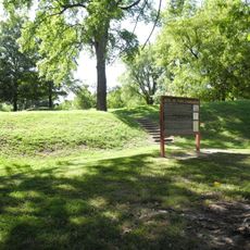
The fenced site lies southeast of Prairie du Rocher and can be visited without paying an entrance fee. The ground can be uneven, so sturdy shoes are a good idea before heading out.

The sediment layers beneath the overhang are among the deepest and most complete records from a single site in the region east of the Mississippi. This depth allowed researchers to follow changes in the way people lived over thousands of years without moving to another location.

The community of curious travelers

AroundUs brings together thousands of curated places, local tips, and hidden gems, enriched daily by 60,000 contributors worldwide.

Start exploring
GPS coordinates
38.06283,-90.06400
Latest update
March 3, 2026 13:59
Around this place
Fort de Chartres
United States of America

Fort de Chartres

8.6 km
Illinois Caverns State Natural Area
United States of America

Illinois Caverns State Natural Area

20.3 km
Fort Kaskaskia State Historic Site
United States of America

Fort Kaskaskia State Historic Site

17 km
Chester Bridge
United States of America

Chester Bridge

26.7 km
Louis Bolduc House
United States of America

Louis Bolduc House

9.6 km
Felix Vallé House State Historic Site
United States of America

Felix Vallé House State Historic Site

9.4 km
Pierre Menard House
United States of America

Pierre Menard House

17.4 km
Ste. Genevieve Historic District
United States of America

Ste. Genevieve Historic District

9.4 km
Middle Mississippi River National Wildlife Refuge
United States of America

Middle Mississippi River National Wildlife Refuge

20.8 km
French Colonial Historic District
United States of America

French Colonial Historic District

6.1 km
United States of America

Kaskaskia Bell State Memorial

20.4 km
Amoureux House
United States of America

Amoureux House

10.1 km
Kolmer Site
United States of America

Kolmer Site

10.7 km
Fults Hill Prairie State Natural Area
United States of America

Fults Hill Prairie State Natural Area

25 km
Creole House
United States of America

Creole House

3.9 km
Jacques Guibourd Historic House
United States of America

Jacques Guibourd Historic House

9.4 km
Sacred Heart Roman Catholic Church
United States of America

Sacred Heart Roman Catholic Church

22.2 km
Mary's River Covered Bridge
United States of America

Mary's River Covered Bridge

29.1 km
Le Grand Champ Bottom
United States of America

Le Grand Champ Bottom

14.1 km
Randolph County Courthouse
United States of America

Randolph County Courthouse

27.2 km
Red Bud Historic District
United States of America

Red Bud Historic District

17.4 km
Frederick Weistar House
United States of America

Frederick Weistar House

27.2 km
Christian F. Weinrich House
United States of America

Christian F. Weinrich House

27.2 km
Bequette-Ribault House
United States of America

Bequette-Ribault House

10.2 km
Ste. Geneviève National Historical Park
United States of America

Ste. Geneviève National Historical Park

9.5 km
Jean-Baptiste Vallé House
United States of America

Jean-Baptiste Vallé House

9.5 km
Lasource-Durand House
United States of America

Lasource-Durand House

10.2 km
Kidd Lake State Natural Area
United States of America

Kidd Lake State Natural Area

15.6 km
Show the full map
Reviews
Share your experience

No review yet

Discussions
Start a discussion...

No discussion yet

« Modoc Rock Shelter - Archaeological site near Prairie du Rocher, Illinois, US » is provided by Around Us (aroundus.com). Images and texts are derived from Wikimedia project under a Creative Commons license. You are allowed to copy, distribute, and modify copies of this page, under the conditions set by the license, as long as this note is clearly visible.

Discover hidden gems everywhere you go!

From secret cafés to breathtaking viewpoints, skip the crowded tourist spots and find places that match your style. Our app makes it easy with voice search, smart filtering, route optimization, and insider tips from travelers worldwide. Download now for the complete mobile experience.

Around Us App Screenshot

A unique approach to discovering new places

Le Figaro

All the places worth exploring

France Info

A tailor-made excursion in just a few clicks

20 Minutes

Around Us
Travel Guide & Maps
Download

Send to your phone

QR Code
1

Open the camera app on your mobile.

2

Point at the QR code with your camera. A notification will appear.

3

Tap the notification to open the link.