Chest opened
+${chestReward.xp} XP
Explorer
NOUVEAU ×${chestReward.collectible.quantity}
tapez pour fermer
Chest locked

Open chests in the app

Around Us is built for your phone — chests unlock when you walk, explore and capture nearby places.

Enable Location

We need your location to show you interesting places around you

Discover nearby places

Find interesting locations and hidden gems around you

Precise directions

Get accurate directions and distances to places

Your location is never shared with other users. It's only used when you tap the location button.

Texas Tower 4

Log in to your account

Start exploring — it's free

Trusted by 72,893 travelers worldwide

Continue with Google
Continue with Apple
or

We will send you a code to connect

By continuing, you accept our Terms and Conditions and our Privacy Policy

Check your inbox

We've sent a pincode in your inbox. Please enter the code below.

Texas Tower 4
Discussion Reviews 1 Photos
15.9k Popularity

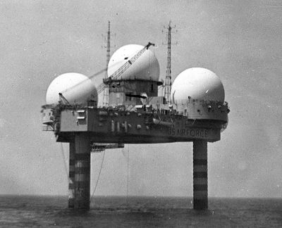
Texas Tower 4, radar station of the United States Air Force

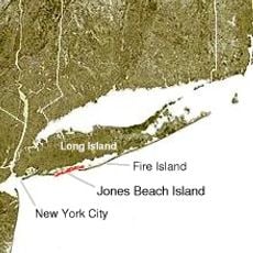
Texas Tower 4 was a radar station built by the US Air Force, located about 60 miles off the coast of Long Island, New York, in the Atlantic Ocean. The steel platform resembled an oil rig and was equipped with search radars and height-finder radars to detect aircraft up to 500 miles away.

Construction began in December 1956, and the station was towed to its position in 1957, sustaining storm damage to its support legs that were repaired later. In January 1961, a winter storm destroyed the already-weakened platform, killing all 28 crew members and leading to the closure of the entire Texas Tower system.

The wreckage rests about 185 feet deep on the ocean floor and is accessible only to experienced divers with proper deep-diving equipment and training. A buoy from the National Oceanic and Atmospheric Administration marks the exact location for diving operations.

The platform earned the nickname 'Old Shaky' because rotating antennas and generators caused constant vibrations that made the steel legs sway. During its 1957 tow to position, it lost two support legs in a storm, and after Hurricane Donna in 1960, it was so structurally weakened that collapse became inevitable.

The community of curious travelers

AroundUs brings together thousands of curated places, local tips, and hidden gems, enriched daily by 60,000 contributors worldwide.

Start exploring
Inception
1958
GPS coordinates
39.80000,-72.66670
Latest update
February 19, 2026 23:20
Around this place
United States of America

Oak Beach Inn

107.3 km
Fire Island Light
United States of America

Fire Island Light

103.9 km
Outer barrier
United States of America

Outer barrier

104.3 km
Captree State Park
United States of America

Captree State Park

106 km
Lighthouse Beach
United States of America

Lighthouse Beach

103.6 km
Otis Pike Fire Island High Dune Wilderness
United States of America

Otis Pike Fire Island High Dune Wilderness

103.9 km
Fire Island Inlet
United States of America

Fire Island Inlet

107.3 km
William Floyd House
United States of America

William Floyd House

108.7 km
Fire Island Inlet Bridge
United States of America

Fire Island Inlet Bridge

105.6 km
Robert Moses State Park
United States of America

Robert Moses State Park

104.3 km
Cedar Beach
United States of America

Cedar Beach

108.9 km
Carrington House
United States of America

Carrington House

102.1 km
Smith Point Bridge
United States of America

Smith Point Bridge

105.8 km
Priscilla
United States of America

Priscilla

109 km
State Boat Channel Bridge
United States of America

State Boat Channel Bridge

106.6 km
Long Island Maritime Museum
United States of America

Long Island Maritime Museum

109 km
Modesty
United States of America

Modesty

109 km
Cherry Grove Community House and Theatre
United States of America

Cherry Grove Community House and Theatre

102.3 km
Bellport Village Historic District
United States of America

Bellport Village Historic District

109.1 km
Bellport Academy
United States of America

Bellport Academy

108.7 km
Rudolph Oyster House
United States of America

Rudolph Oyster House

109 km
Foster Ave Beach
United States of America

Foster Ave Beach

108.6 km
Shirley Beach
United States of America

Shirley Beach

107.5 km
Cedar Overlook Beach
United States of America

Cedar Overlook Beach

108.6 km
West Beach
United States of America

West Beach

108.8 km
Sayville Bathing Beach
United States of America

Sayville Bathing Beach

108.5 km
Cupsoque Beach
United States of America

Cupsoque Beach

108 km
Atlantique Beach
United States of America

Atlantique Beach

103.1 km
Show the full map
Reviews
Share your experience

No review yet

Discussions
Start a discussion...

No discussion yet

« Texas Tower 4 - radar station of the United States Air Force » is provided by Around Us (aroundus.com). Images and texts are derived from Wikimedia project under a Creative Commons license. You are allowed to copy, distribute, and modify copies of this page, under the conditions set by the license, as long as this note is clearly visible.

Discover hidden gems everywhere you go!

From secret cafés to breathtaking viewpoints, skip the crowded tourist spots and find places that match your style. Our app makes it easy with voice search, smart filtering, route optimization, and insider tips from travelers worldwide. Download now for the complete mobile experience.

Around Us App Screenshot

A unique approach to discovering new places

Le Figaro

All the places worth exploring

France Info

A tailor-made excursion in just a few clicks

20 Minutes

Around Us
Travel Guide & Maps
Download

Send to your phone

QR Code
1

Open the camera app on your mobile.

2

Point at the QR code with your camera. A notification will appear.

3

Tap the notification to open the link.