Enable Location

We need your location to show you interesting places around you

Discover nearby places

Find interesting locations and hidden gems around you

Precise directions

Get accurate directions and distances to places

Your location is never shared with other users. It's only used when you tap the location button.

Log in to your account

Start exploring — it's free

Trusted by 61,423 travelers worldwide

Continue with Google
Continue with Apple
or

We will send you a code to connect

By continuing, you accept our Terms and Conditions and our Privacy Policy

Check your inbox

We've sent a pincode in your inbox. Please enter the code below.

Sheepskin Trail

Sheepskin Trail, Hiking trail in Fayette County, Pennsylvania.

Description

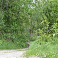
The Sheepskin Trail is a hiking path in Fayette County that winds through changing landscapes with gravel and paved sections along the Monongahela River. The route connects communities from Dunbar Township to Point Marion Borough.

History

The area originated as an old railroad corridor that was transformed into a recreational pathway. This conversion made Pennsylvania's natural landscapes accessible to walkers and cyclists.

Culture

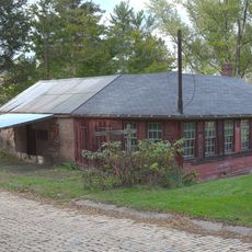
The trail system integrates with the Mon River Trails Conservancy and Great Allegheny Passage, creating connections between different communities in Fayette County.

Practical

The route has multiple access points, with the Point Marion trailhead offering parking and bikeshare services. Visitors should know the terrain is flat and easy to walk, making it suitable for various fitness levels.

Did you know?

A former interstate structure has been repurposed as a covered bridge in Hutchinson Park. This unusual construction creates a distinctive crossing point along the route.

Location
GPS coordinates
39.90080,-79.72760
Latest update
December 14, 2025 09:41

AroundUs brings together thousands of curated places, local tips, and hidden gems, enriched daily by 60,000 contributors worldwide. Discover all places nearby (Fayette County).

Around this place
Laurel Caverns
United States of America

Laurel Caverns

11.3 km
Summit Hotel
United States of America

Summit Hotel

8.1 km
Mount Saint Macrina
United States of America

Mount Saint Macrina

1.9 km
Quebec Run Wild Area
United States of America

Quebec Run Wild Area

16.3 km
Searights Tollhouse, National Road
United States of America

Searights Tollhouse, National Road

7.7 km
Isaac Meason House
United States of America

Isaac Meason House

8.2 km
Fort Necessity
United States of America

Fort Necessity

15.2 km
Adam Clarke Nutt Mansion
United States of America

Adam Clarke Nutt Mansion

1 km
Peter Colley Tavern and Barn
United States of America

Peter Colley Tavern and Barn

12.5 km
State Theatre Center for the Arts
United States of America

State Theatre Center for the Arts

279 m
Andrew Rabb House
United States of America

Andrew Rabb House

15.7 km
John S. Douglas House
United States of America

John S. Douglas House

580 m
Oak Hill Estate
United States of America

Oak Hill Estate

16.7 km
Uniontown Downtown Historic District
United States of America

Uniontown Downtown Historic District

155 m
Wharton Furnace
United States of America

Wharton Furnace

11.3 km
Wallace-Baily Tavern
United States of America

Wallace-Baily Tavern

14.8 km
Brier Hill
United States of America

Brier Hill

12.4 km
John P. Conn House
United States of America

John P. Conn House

644 m
Hopwood-Miller Tavern
United States of America

Hopwood-Miller Tavern

2.9 km
Laurel Hill Presbyterian Church
United States of America

Laurel Hill Presbyterian Church

8.8 km
Shoaf Historic District
United States of America

Shoaf Historic District

9.5 km
Smock Historic District
United States of America

Smock Historic District

9.5 km
Springer Farm
United States of America

Springer Farm

16.7 km
Hugh Laughlin House
United States of America

Hugh Laughlin House

14.5 km
Johnson-Hatfield Tavern
United States of America

Johnson-Hatfield Tavern

11.5 km
Brown-Moore Blacksmith Shop
United States of America

Brown-Moore Blacksmith Shop

16.7 km
Cucumber Run
United States of America

Cucumber Run

16.8 km
Downer Tavern
United States of America

Downer Tavern

11.3 km
Show the full map
« Sheepskin Trail - Hiking trail in Fayette County, Pennsylvania » is provided by Around Us (aroundus.com). Images and texts are derived from Wikimedia project under a Creative Commons license. You are allowed to copy, distribute, and modify copies of this page, under the conditions set by the license, as long as this note is clearly visible.

Discover hidden gems everywhere you go!

From secret cafés to breathtaking viewpoints, skip the crowded tourist spots and find places that match your style. Our app makes it easy with voice search, smart filtering, route optimization, and insider tips from travelers worldwide. Download now for the complete mobile experience.

Around Us App Screenshot

A unique approach to discovering new places

Le Figaro

All the places worth exploring

France Info

A tailor-made excursion in just a few clicks

20 Minutes

Around Us
Travel Guide & Maps
Download

Send to your phone

QR Code
1

Open the camera app on your mobile.

2

Point at the QR code with your camera. A notification will appear.

3

Tap the notification to open the link.