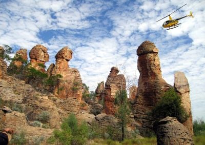
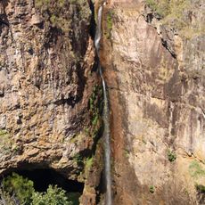
The Lost City, Rock formation in Litchfield National Park, Australia.
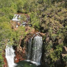
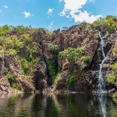
The Lost City is a sandstone formation in Litchfield National Park featuring tall walls and narrow passages that resemble ancient structures set in the landscape. The rock blocks create walkways and platforms spread across the site, with sections rising at varying heights throughout the terrain.
The sandstone formations developed through natural erosion over millions of years, shaping the landscape into what visitors see today. This geological process created the rock blocks and passages that define the site's character.
The rock formations hold meaning for local Indigenous communities whose deep connection to this land is woven into the stories and names of the area. Visitors can sense this relationship in how the stones sit naturally within the surrounding landscape.
The site is accessible only by four-wheel drive vehicle, and roads close during the wet season. Visitors should check conditions beforehand and be prepared for rough terrain.
The maze-like layout of rock blocks is not human-made but the result of natural erosion patterns that create nearly uniform walls. This accidental effect of nature turns walking through the passages into a kind of exploration.
Location: Northern Territory
GPS coordinates: -13.21714,130.73555
Latest update: December 6, 2025 19:09
The Australian outback encompasses a vast territory featuring distinctive geological characteristics, including ancient sandstone formations, deep canyons, and expansive salt lakes. This region contains some of Earth's oldest landscapes, from the red monoliths of the Northern Territory to the layered rock formations of Western Australia. Visitors can explore underground settlements created as shelter from extreme temperatures, as well as impact craters dating back millions of years. The collection includes sites such as Uluru and Kata Tjuta in the Northern Territory, which represent massive red sandstone formations. Kings Canyon offers tall sandstone cliffs and gorges, while Purnululu National Park in Western Australia is known for its orange and black striped sandstone domes. Other notable locations include the Devils Marbles (Karlu Karlu), rounded granite boulders in the Northern Territory, and Wolfe Creek Crater, one of the world's largest meteorite craters. Karijini National Park displays deep gorges with layered rock, while Ningaloo Reef on the western coast hosts a coral reef system. The region also contains rainforest areas such as the Daintree Rainforest in Queensland and wilderness areas in Tasmania.
Litchfield National Park
19 km
Mindil Beach
86.6 km
Charles Darwin National Park
86.5 km
Government House, Darwin
84.2 km
Florence Falls
14.1 km
Parliament House
84.4 km
Wangi Falls
8.1 km
Lake Bennett
54.7 km
Evolution on Gardiner
85.1 km
St Mary's Star of the Sea Cathedral
85.1 km
Territory Wildlife Park
62.8 km
Stokes Hill Wharf
84.1 km
Elizabeth River Bridge
79.7 km
Tolmer Falls
2.6 km
Adelaide River War Cemetery
41.1 km
Burnett House (Darwin, Northern Territory)
85.9 km
Lameroo Beach
84.5 km
Library & Archives NT
84.4 km
Outrigger Pandanas
85 km
Emery Point Light
85.4 km
Stella Maris
84.6 km
Lyons Cottage
84.5 km
Brown's Mart
84.5 km
Damoe-Ra Park
84.3 km
Litchfield Banyan Tree Resort
33.5 km
Zebra Stone
31 km
Silversands
81.3 km
Office of the Administrator, Darwin
84.4 kmReviews
Visited this place? Tap the stars to rate it and share your experience / photos with the community! Try now! You can cancel it anytime.
Discover hidden gems everywhere you go!
From secret cafés to breathtaking viewpoints, skip the crowded tourist spots and find places that match your style. Our app makes it easy with voice search, smart filtering, route optimization, and insider tips from travelers worldwide. Download now for the complete mobile experience.
A unique approach to discovering new places❞
— Le Figaro
All the places worth exploring❞
— France Info
A tailor-made excursion in just a few clicks❞
— 20 Minutes