Bennett-Bean Covered Bridge

Log in to your account

AroundUs is a community-driven map of interesting places, built by curious explorers like you. It grows with every review, story, and photo you share.
Connect to save your favorite spots, contribute locations, and create personalized routes.
By continuing, you accept our Terms and Conditions and our Privacy Policy

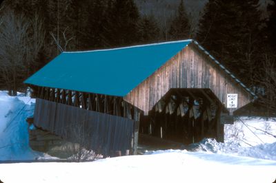
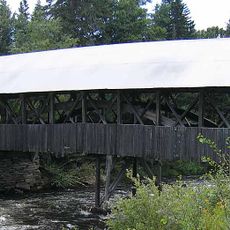
Bennett-Bean Covered Bridge, Covered bridge in Oxford County, Maine, United States.
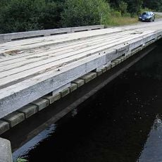
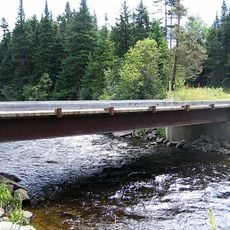
The Bennett-Bean Covered Bridge spans 93 feet across the Magalloway River with vertical boarding on its sides and wire cables anchored to concrete settings.

Built in 1901 at a cost under 1,000 dollars, this bridge served as a crucial connection for local farms to Maine State Route 16 until 1985.

The National Register of Historic Places recognized this bridge in 1970 for its representation of early American transportation infrastructure and engineering methods.
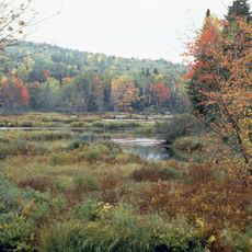
Located 1.5 miles south of Wilson Mills, the structure measures 16 feet 8 inches wide and features an interior roadway width of 14 feet 8 inches.

The bridge incorporates Paddleford trusses with diagonal cross members fastened to King posts using metal bolts for enhanced structural stability.

Location: Oxford County

Inception: 1898

GPS coordinates: 44.91914,-71.03839

Latest update: September 23, 2025 16:46

Around this place
Show the full map
Orgonon
United States of America

Orgonon

26.4 km
Great North Woods Region
United States of America

Great North Woods Region

32.8 km
Grafton Notch State Park
United States of America

Grafton Notch State Park

37 km
Angel Falls
United States of America

Angel Falls

30.1 km
Baldpate Mountain
United States of America

Baldpate Mountain

36.4 km
Dixville Notch State Park
United States of America

Dixville Notch State Park

20.9 km
Rangeley Lake State Park
United States of America

Rangeley Lake State Park

27.3 km
Forest Lodge
United States of America

Forest Lodge

18.3 km
Pittsburg–Clarksville Covered Bridge
United States of America

Pittsburg–Clarksville Covered Bridge

32.7 km
Coleman State Park
United States of America

Coleman State Park

23 km
Umbagog National Wildlife Refuge
United States of America

Umbagog National Wildlife Refuge

14.6 km
Umbagog Lake State Park
United States of America

Umbagog Lake State Park

24.2 km
Mollidgewock State Park
United States of America

Mollidgewock State Park

21.8 km
Beaver Brook Falls Wayside
United States of America

Beaver Brook Falls Wayside

33.5 km
Mount Kelsey
United States of America

Mount Kelsey

25.4 km
Androscoggin Wayside Park
United States of America

Androscoggin Wayside Park

22.7 km
Indian Stream Schoolhouse
United States of America

Indian Stream Schoolhouse

35 km
Benjamin Aldrich Homestead
United States of America

Benjamin Aldrich Homestead

34.5 km
Rangeley Public Library
United States of America

Rangeley Public Library

31.5 km
Upper Dallas School
United States of America

Upper Dallas School

34.8 km
Rangeley Trust Company Building
United States of America

Rangeley Trust Company Building

31.6 km
Cascade Stream Gorge Trail
United States of America

Cascade Stream Gorge Trail

33.7 km
Forest Access Road bridge over the Connecticut River
United States of America

Forest Access Road bridge over the Connecticut River

26.9 km
U.S. Route 3 Bridge over the Connecticut River
United States of America

U.S. Route 3 Bridge over the Connecticut River

32.4 km
Scott Brook Road bridge over the Connecticut River
United States of America

Scott Brook Road bridge over the Connecticut River

31.2 km
Magalloway Road Bridge over the Connecticut River
United States of America

Magalloway Road Bridge over the Connecticut River

25.9 km
Pontook Reservoir
United States of America

Pontook Reservoir

35.9 km
Second Connecticut Lake
United States of America

Second Connecticut Lake

28.3 km
Show the full map

Reviews

Visited this place? Tap the stars to rate it and share your experience / photos with the community! Try now! You can cancel it anytime.

« Bennett-Bean Covered Bridge - Covered bridge in Oxford County, Maine, United States. » is provided by Around Us (aroundus.com). Images and texts are derived from Wikimedia project under a Creative Commons license. You are allowed to copy, distribute, and modify copies of this page, under the conditions set by the license, as long as this note is clearly visible.

Discover hidden gems everywhere you go!

From secret cafés to breathtaking viewpoints, skip the crowded tourist spots and find places that match your style. Our app makes it easy with voice search, smart filtering, route optimization, and insider tips from travelers worldwide. Download now for the complete mobile experience.

Around Us App Screenshot

A unique approach to discovering new places

Le Figaro

All the places worth exploring

France Info

A tailor-made excursion in just a few clicks

20 Minutes