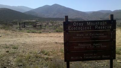
Otay Mountain Wilderness, Protected wilderness area in San Diego County, US.
Otay Mountain Wilderness is a protected mountainous area covering more than 16,000 acres (6,500 hectares) located along the California-Mexico border. The terrain rises to nearly 3,500 feet (1,100 meters) and features a rugged landscape with canyons, ridges, and native plants adapted to arid conditions.
This land received official protection in 1999 when Congress designated it as a wilderness area to prevent commercial development. The designation came after years of conservation efforts to safeguard the fragile ecosystems and rare species living in the region.
This place shelters rare plants and animals found nowhere else in such concentrations. Visitors can walk through habitats that are essential to species that depend on these specific conditions for survival.
Access is only on foot since motorized vehicles and all mechanical transport are prohibited in the area. Visitors should bring maps and extra water, as the terrain is dry and has no facilities or marked trails to follow.
This location holds the only remaining population of Mexican flannel bush and the largest natural collection of Tecate cypress trees on Earth. These rare plants would have been lost or severely depleted without the protection this wilderness provides.
The community of curious travelers
AroundUs brings together thousands of curated places, local tips, and hidden gems, enriched daily by 60,000 contributors worldwide.