Chest opened
+${chestReward.xp} XP
Explorer
NOUVEAU ×${chestReward.collectible.quantity}
tapez pour fermer
Chest locked

Open chests in the app

Around Us is built for your phone — chests unlock when you walk, explore and capture nearby places.

Enable Location

We need your location to show you interesting places around you

Discover nearby places

Find interesting locations and hidden gems around you

Precise directions

Get accurate directions and distances to places

Your location is never shared with other users. It's only used when you tap the location button.

Log in to your account

Start exploring — it's free

Trusted by 72,941 travelers worldwide

Continue with Google
Continue with Apple
or

We will send you a code to connect

By continuing, you accept our Terms and Conditions and our Privacy Policy

Check your inbox

We've sent a pincode in your inbox. Please enter the code below.

Sonestown, Pennsylvania
Discussion Reviews Photo
1.6k Popularity

Sonestown, Pennsylvania, Rural community in Sullivan County, Pennsylvania

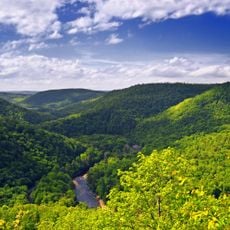
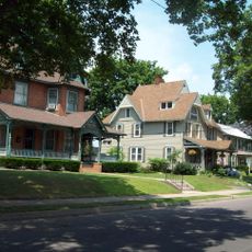
Sonestown is a rural community in Davidson Township situated along Route 220, featuring local businesses and residential areas. The settlement is surrounded by woodland landscapes that define the area.

George Sones founded the settlement in 1843 with a sawmill that became a center for lumber production. This drove economic growth in the region during the late 1800s.

The community maintains its connections through regular craft fairs and festivals that gather residents throughout the year. These events shape local social life and reflect how people here value their shared traditions.

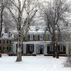
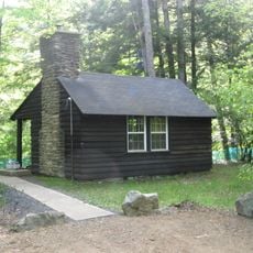
A local inn provides lodging and a restaurant where travelers can eat and stay. This serves as a good base for visitors who want to explore the surrounding woodland region.

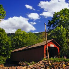
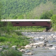
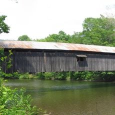
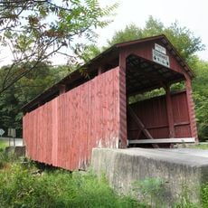
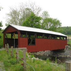
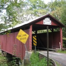
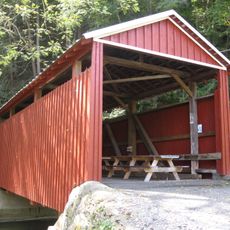
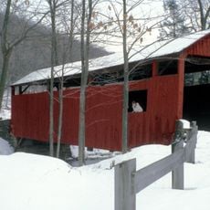
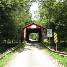
About one mile south on Route 220 stands the Sonestown Covered Bridge, a preserved structure from the region's industrial era. The bridge displays 19th-century construction methods and marks the timber trade routes that once flowed through the area.

The community of curious travelers

AroundUs brings together thousands of curated places, local tips, and hidden gems, enriched daily by 60,000 contributors worldwide.

Start exploring
Location
GPS coordinates
41.35361,-76.55417
Latest update
December 14, 2025 13:01
Around this place
Ricketts Glen State Park
United States of America

Ricketts Glen State Park

24.6 km
Worlds End State Park
United States of America

Worlds End State Park

13.2 km
Sonestown Covered Bridge
United States of America

Sonestown Covered Bridge

807 m
Clemuel Ricketts Mansion
United States of America

Clemuel Ricketts Mansion

19.5 km
Forksville Covered Bridge
United States of America

Forksville Covered Bridge

15.5 km
Hillsgrove Covered Bridge
United States of America

Hillsgrove Covered Bridge

15.4 km
Plunketts Creek Bridge No. 3
United States of America

Plunketts Creek Bridge No. 3

21.7 km
State Game Lands Number 13
United States of America

State Game Lands Number 13

11.5 km
Central Mountain
United States of America

Central Mountain

18.4 km
Carl E. Stotz Memorial Little League Bridge
United States of America

Carl E. Stotz Memorial Little League Bridge

23.9 km
State Game Lands Number 226
United States of America

State Game Lands Number 226

25 km
Eagles Mere Historic District
United States of America

Eagles Mere Historic District

7.3 km
St. James Episcopal Church
United States of America

St. James Episcopal Church

25.7 km
Creasyville Covered Bridge
United States of America

Creasyville Covered Bridge

17.6 km
United States of America

Sullivan County Courthouse

9.3 km
Eagles Mere Air Museum
United States of America

Eagles Mere Air Museum

7.2 km
Lairdsville Covered Bridge
United States of America

Lairdsville Covered Bridge

17.7 km
Sam Eckman Covered Bridge No. 92
United States of America

Sam Eckman Covered Bridge No. 92

20.3 km
Lake Rose
United States of America

Lake Rose

21.8 km
Muncy Historic District
United States of America

Muncy Historic District

25.5 km
Shoemaker Covered Bridge
United States of America

Shoemaker Covered Bridge

22.6 km
Y Covered Bridge No. 156
United States of America

Y Covered Bridge No. 156

17.4 km
Jud Christie Covered Bridge No. 95
United States of America

Jud Christie Covered Bridge No. 95

18.8 km
Cox Run
United States of America

Cox Run

22.6 km
Trout Pond Park
United States of America

Trout Pond Park

21.8 km
Worlds End State Park Family Cabin District
United States of America

Worlds End State Park Family Cabin District

12.7 km
Loyalsock Trail
United States of America

Loyalsock Trail

8.5 km
Houseknecht Farm
United States of America

Houseknecht Farm

21.1 km
Show the full map
Reviews
Share your experience

No review yet

Discussions
Start a discussion...

No discussion yet

« Sonestown, Pennsylvania - Rural community in Sullivan County, Pennsylvania » is provided by Around Us (aroundus.com). Images and texts are derived from Wikimedia project under a Creative Commons license. You are allowed to copy, distribute, and modify copies of this page, under the conditions set by the license, as long as this note is clearly visible.

Discover hidden gems everywhere you go!

From secret cafés to breathtaking viewpoints, skip the crowded tourist spots and find places that match your style. Our app makes it easy with voice search, smart filtering, route optimization, and insider tips from travelers worldwide. Download now for the complete mobile experience.

Around Us App Screenshot

A unique approach to discovering new places

Le Figaro

All the places worth exploring

France Info

A tailor-made excursion in just a few clicks

20 Minutes

Around Us
Travel Guide & Maps
Download

Send to your phone

QR Code
1

Open the camera app on your mobile.

2

Point at the QR code with your camera. A notification will appear.

3

Tap the notification to open the link.