Chest opened
+${chestReward.xp} XP
Explorer
NOUVEAU ×${chestReward.collectible.quantity}
tapez pour fermer
Chest locked

Open chests in the app

Around Us is built for your phone — chests unlock when you walk, explore and capture nearby places.

Enable Location

We need your location to show you interesting places around you

Discover nearby places

Find interesting locations and hidden gems around you

Precise directions

Get accurate directions and distances to places

Your location is never shared with other users. It's only used when you tap the location button.

Log in to your account

Start exploring — it's free

Trusted by 72,887 travelers worldwide

Continue with Google
Continue with Apple
or

We will send you a code to connect

By continuing, you accept our Terms and Conditions and our Privacy Policy

Check your inbox

We've sent a pincode in your inbox. Please enter the code below.

Discussion Reviews Photo
1.3k Popularity

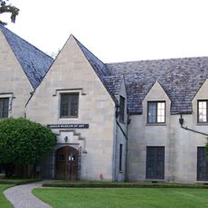
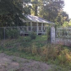
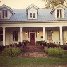
Cedars Plantation, Colonial agricultural residence in Oak Ridge, Louisiana, US

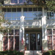
Cedars Plantation is a one-and-a-half-story wooden residence in Morehouse Parish, Louisiana, with chimneys on the exterior ends and a covered porch. The property includes several original outbuildings such as a carriage house, log smokehouse, milk house, and cotton storage structure spread across 4 acres.

John Williams constructed the plantation in 1840 using timber that enslaved people transported from Natchez, Mississippi. The building later became recognized as the oldest house in Morehouse Parish.

The wooden structure displays typical features of early Louisiana architecture with a central entrance hall and spacious rooms on either side. Visitors can observe how this layout organized daily life in a plantation residence of that era.

The property is located in a rural area southwest of Oak Ridge and is best reached by car. It helps to check in advance about visiting conditions and opening times, since the site is not always open to the public.

The plantation has remained in continuous family ownership since its founding and is managed by descendants of the original Williams family. This unbroken family continuity across generations is rare and makes the site a living example of how one family has stayed rooted at a historic place.

The community of curious travelers

AroundUs brings together thousands of curated places, local tips, and hidden gems, enriched daily by 60,000 contributors worldwide.

Start exploring
Location
Inception
1840
GPS coordinates
32.61556,-91.81278
Latest update
December 14, 2025 18:12
Around this place
Poverty Point
United States of America

Poverty Point

37.7 km
Watson Brake
United States of America

Watson Brake

40.6 km
Bayou Bartholomew
United States of America

Bayou Bartholomew

26.4 km
JPS Field at Malone Stadium
United States of America

JPS Field at Malone Stadium

25.5 km
Chennault Aviation and Military Museum
United States of America

Chennault Aviation and Military Museum

25.5 km
Biedenharn Museum and Gardens
United States of America

Biedenharn Museum and Gardens

31.7 km
Poverty Point Reservoir State Park
United States of America

Poverty Point Reservoir State Park

33.3 km
Louisiana Purchase Gardens and Zoo
United States of America

Louisiana Purchase Gardens and Zoo

31.2 km
Chemin-A-Haut State Park
United States of America

Chemin-A-Haut State Park

32.9 km
Jordan Mounds
United States of America

Jordan Mounds

5.9 km
United States of America

Mott Archaeological Preserve

44.7 km
High Delta Safari Park
United States of America

High Delta Safari Park

28.5 km
D'Arbonne National Wildlife Refuge
United States of America

D'Arbonne National Wildlife Refuge

37.9 km
Masur Museum of Art
United States of America

Masur Museum of Art

31.4 km
Fiske Theatre
United States of America

Fiske Theatre

48.3 km
Crossett Experimental Forest
United States of America

Crossett Experimental Forest

48 km
Rose Theatre
United States of America

Rose Theatre

20.4 km
Raffman Site
United States of America

Raffman Site

46.5 km
First United Methodist Church
United States of America

First United Methodist Church

32 km
Crossett Methodist Church
United States of America

Crossett Methodist Church

59 km
Morehouse Parish Courthouse
United States of America

Morehouse Parish Courthouse

20.4 km
Boscobel Cottage
United States of America

Boscobel Cottage

44.8 km
Crossett Municipal Building
United States of America

Crossett Municipal Building

58.7 km
Winnsboro Commercial Historic District
United States of America

Winnsboro Commercial Historic District

51.1 km
Vickers House
United States of America

Vickers House

29 km
Historic Biedenharn Home
United States of America

Historic Biedenharn Home

31.7 km
Northeast Louisiana Children's
United States of America

Northeast Louisiana Children's

31.4 km
Mascur Museum
United States of America

Mascur Museum

31.5 km
Show the full map
Reviews
Share your experience

No review yet

Discussions
Start a discussion...

No discussion yet

« Cedars Plantation - Colonial agricultural residence in Oak Ridge, Louisiana, US » is provided by Around Us (aroundus.com). Images and texts are derived from Wikimedia project under a Creative Commons license. You are allowed to copy, distribute, and modify copies of this page, under the conditions set by the license, as long as this note is clearly visible.

Discover hidden gems everywhere you go!

From secret cafés to breathtaking viewpoints, skip the crowded tourist spots and find places that match your style. Our app makes it easy with voice search, smart filtering, route optimization, and insider tips from travelers worldwide. Download now for the complete mobile experience.

Around Us App Screenshot

A unique approach to discovering new places

Le Figaro

All the places worth exploring

France Info

A tailor-made excursion in just a few clicks

20 Minutes

Around Us
Travel Guide & Maps
Download

Send to your phone

QR Code
1

Open the camera app on your mobile.

2

Point at the QR code with your camera. A notification will appear.

3

Tap the notification to open the link.