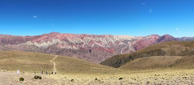
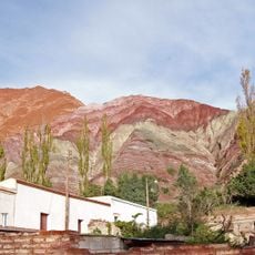
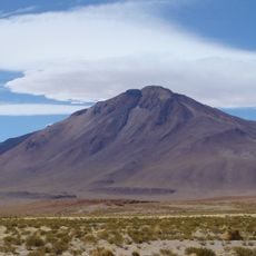
Serranía de Hornocal, Mountain range in Humahuaca, Argentina.
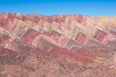
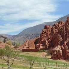
Serranía de Hornocal is a mountain range in the Quebrada de Humahuaca region of northwestern Argentina that spans a wide area. The range consists of layered formations of limestone and other minerals that appear in different tones, shaping the character of the landscape.
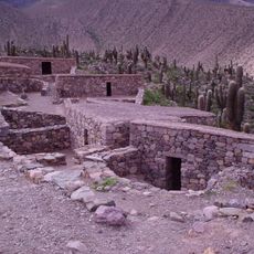
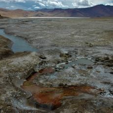
The range formed through geological processes that built up layers of different minerals over millions of years. These formations connect with similar structures that extend across several countries along the Andean highlands.
This mountain range holds deep meaning for Andean communities who have long regarded these peaks as sacred places. The slopes and passes have connected settlements across the region for centuries, shaping how local people move through and relate to the land.
The best time to visit is during months with less rain, when the walking routes are accessible and visibility remains clear. It is wise to plan for warm clothing and protection from high-altitude sun exposure, as the terrain is exposed and open.
The mountain layers display natural color patterns created by varying mineral composition that become especially vivid after rainfall. These colored stripes result from iron oxides and other natural pigments present in the different geological strata.
Location: Jujuy Province
Elevation above the sea: 4,761 m
GPS coordinates: -23.23571,-65.18584
Latest update: December 20, 2025 15:10
Northwest Argentina is a region where deserts, wine regions and Andean valleys coexist. Salt flats, striking rock formations, pre-Columbian sites and traditional mountain villages define this landscape. The terrain shifts between bare highlands, colorful mountain ranges and green valleys where small...
Quebrada de Humahuaca
17.1 km
Pucará de Tilcara
45.1 km
Calilegua National Park
57.3 kmBaritú National Park
93.2 km
Tariquía Flora and Fauna National Reserve
164 km
Polvorilla viaduct
165.1 km
Monument to the Heroes of Independence
17.2 km
Reserva de biosfera de Yungas
32.4 km
Tastil
156.5 km
Palacio de Gobierno de Jujuy
106.5 km
Catedral Basílica de San Salvador de Jujuy
106.4 km
Cerro Tuzgle
160.4 km
Cabildo de Humahuaca
17 km
Finca Castañares
167.9 km
Fuerte de Cobos
167.3 km
Capilla de la Inmaculada Concepción
27.7 km
Campo de San Lorenzo
167.3 km
Paseo de los Colorados
65.7 km
Cerro Galán
140.3 km
Humahuaca Cathedral
17.1 km
Biblioteca Popular José Ingenieros
82.6 km
Capilla de Tilcara
43.4 km
Iglesia y Convento San Francisco
106.4 km
Cabildo de la ciudad de San Salvador de Jujuy
106.3 km
Capilla de Purmamarca
65.3 km
Museo De Bellas Artesfundación Hugo Irureta
43.6 km
Iglesia de Susques
122.1 km
Garganta Del Diablo
44.3 kmVisited this place? Tap the stars to rate it and share your experience / photos with the community! Try now! You can cancel it anytime.
Discover hidden gems everywhere you go!
From secret cafés to breathtaking viewpoints, skip the crowded tourist spots and find places that match your style. Our app makes it easy with voice search, smart filtering, route optimization, and insider tips from travelers worldwide. Download now for the complete mobile experience.
A unique approach to discovering new places❞
— Le Figaro
All the places worth exploring❞
— France Info
A tailor-made excursion in just a few clicks❞
— 20 Minutes