
Santo Antônio do Içá, municipality of Brazil
Location: Amazonas
Elevation above the sea: 83 m
Shares border with: Amaturá, Japurá, Jutaí, São Paulo de Olivença, Tabatinga, Tonantins
GPS coordinates: -3.10194,-67.94000
Latest update: March 5, 2025 19:31


Javari Valley
550 km
Amacayacu National Park
254.7 km
Pico da Neblina National Park
440.8 km
Yaigojé-Apaporis National Park
402.4 km
Centro histórico de Iquitos
592.9 km
Santa Rosa Island
256.7 km
Mamirauá Sustainable Development Reserve
268.2 km
Yaguas National Park
398.6 km
Tamshiyacu Tahuayo Regional Conservation Area
603.1 km
Casa Morey
593.5 km
Bellavista-Nanay
593.7 km
Morro dos Seis Lagos Biological Reserve
405.3 km
BAP América
593 km
Antiguos Edificios del Seguro Social de Salud del Perú
593.7 km
Central Amazon Ecological Corridor
25.5 km
Médio Juruá Extractive Reserve
275.3 km
Tefé National Forest
332.3 km
Cué-cué/Marabitanas Indigenous Territory
454.5 km
Iglesia de la Inmaculada Concepción
593.4 km
Chineria Island
258.3 km
Uacari Sustainable Development Reserve
298.7 km
Natural Reserve Palmari
292.8 km
Auatí-Paraná Extractive Reserve
161 km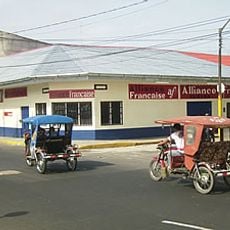
French Alliance of Iquitos
593.5 km
Parroquia de Santa Rosa de Lima (Mazán)
574.1 km
Yaguas River
246.6 km
Ilha Aramacá
258.8 km
Ilhas Arariá
233.9 kmReviews
Visited this place? Tap the stars to rate it and share your experience / photos with the community! Try now! You can cancel it anytime.
Discover hidden gems everywhere you go!
From secret cafés to breathtaking viewpoints, skip the crowded tourist spots and find places that match your style. Our app makes it easy with voice search, smart filtering, route optimization, and insider tips from travelers worldwide. Download now for the complete mobile experience.

A unique approach to discovering new places❞
— Le Figaro
All the places worth exploring❞
— France Info
A tailor-made excursion in just a few clicks❞
— 20 Minutes