Morro dos Seis Lagos Biological Reserve, Biological reserve in São Gabriel da Cachoeira, Brazil
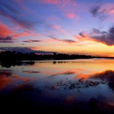
Morro dos Seis Lagos Biological Reserve is a protected area in the Amazon rainforest featuring six interconnected lakes where varying mineral content creates distinct water colors ranging from clear to dark. The terrain is hilly with dense forest cover surrounding the water bodies.
Brazil established this protected area in 1990 to prevent mining activities that threatened the region's natural environment. The designation reflected government commitment to conservation amid external pressures for resource extraction.
Indigenous groups including the Yanomami have inhabited and used these lands for hunting and fishing for countless generations. Their presence continues to shape how the territory functions today.
Entry requires permits obtained through proper channels before arrival, and visitors can reach the area via Highway BR-307 or by boat through the Igarape-Mirim river system. Coordination with local authorities is essential to ensure safe and authorized access.
A thermal spring on the hillside maintains a constant warm temperature year-round, creating an unusual geothermal feature in the rainforest. This hot spring stands out as a distinctive natural phenomenon within the Amazon ecosystem.
Location: Amazonas
Inception: 1990
GPS coordinates: 0.31839,-66.69244
Latest update: December 14, 2025 09:45
Pico da Neblina
93.1 km
Cerro Autana
512 km
Piedra del Cocuy
103.4 km
Pico da Neblina National Park
83.3 km
Pico 31 de Março
93.6 km
Jaú National Park
531.5 km
Serranía La Neblina National Park
101 km
Piedra del Cocuy Natural Monument
103.4 km
Yaigojé-Apaporis National Park
439 km
Parima-Tapirapecó National Park
401.6 km
Yapacana National Park
374.8 km
Duida-Marahuaca National Park
397.2 km
Mamirauá Sustainable Development Reserve
308.3 km
Cachoeira do El Dorado
378.3 km
Cerro Duida
362.9 km
Central Amazon Ecological Corridor
428.5 km
Serra do Aracá State Park
394.9 km
Forte de São José de Marabitanas
84.1 km
Tefé National Forest
466.9 km
Cué-cué/Marabitanas Indigenous Territory
62.1 km
Auatí-Paraná Extractive Reserve
301.1 kmYaguas River
514.2 km
Parú-Euaja Massif Natural Monument
477.6 km
Cerros Vinilla y Aratitiyope Natural Monument
246.1 km
Cuao-Sipapo y Moriche Massif Natural Monument
535.5 km
Monumento Natural Cerro Autana
512 km
Sierra Unturan Natural Monument
212.8 km
Cerros Tapirapecó y Tamacuari Natural Monument
241 kmVisited this place? Tap the stars to rate it and share your experience / photos with the community! Try now! You can cancel it anytime.
Discover hidden gems everywhere you go!
From secret cafés to breathtaking viewpoints, skip the crowded tourist spots and find places that match your style. Our app makes it easy with voice search, smart filtering, route optimization, and insider tips from travelers worldwide. Download now for the complete mobile experience.
A unique approach to discovering new places❞
— Le Figaro
All the places worth exploring❞
— France Info
A tailor-made excursion in just a few clicks❞
— 20 Minutes