Pico da Neblina National Park, National park in northern Amazonas, Brazil
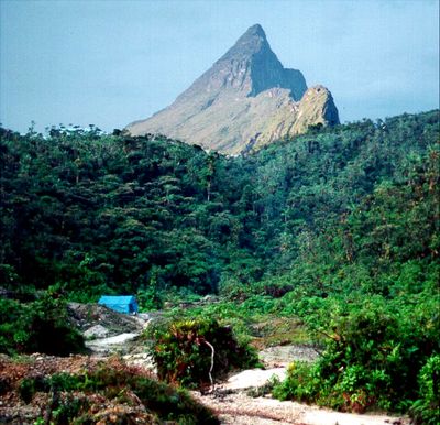
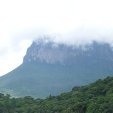
Pico da Neblina is a national park in northern Amazonas, Brazil, encompassing over 2 million hectares of tropical rainforest. The terrain ranges from lowland areas along the Rio Negro to mountain ridges that include the country's highest peaks.
President João Figueiredo created the protected area in 1979 to safeguard the natural resources and biodiversity of this Amazon region. The establishment marked a significant effort to preserve one of Brazil's last large wilderness territories.
The Yanomami people have inhabited these forests for generations, living according to their customs and shaping the land through their presence. Visitors encounter these communities and see directly how the people are connected to the forest and its rhythms.
To visit, you need a permit from ICMBio and must work with authorized Yanomami guides who know the terrain. Proper preparation and local support are essential for exploring the trails and climbing routes safely.
The park contains Brazil's two highest mountains: Pico da Neblina at 3,014 meters (9,888 feet) and Pico 31 de Março at 2,992 meters (9,817 feet). These peaks are rarely visited and offer climbers a genuine challenge in a remote setting.
Operator: Instituto Chico Mendes de Conservação da Biodiversidade
GPS coordinates: 0.31860,-65.94434
Latest update: December 8, 2025 19:51
Pico da Neblina
54.1 km
Piedra del Cocuy
141.5 km
Pico 31 de Março
54.6 km
Jaú National Park
462.5 km
Serranía La Neblina National Park
70.8 km
Piedra del Cocuy Natural Monument
141.5 km
Jaua-Sarisariñama National Park
522.1 km
Parima-Tapirapecó National Park
362.5 km
Yapacana National Park
386.2 km
Duida-Marahuaca National Park
375.7 km
Mamirauá Sustainable Development Reserve
288.6 km
Cachoeira do El Dorado
296.5 km
Cerro Duida
345.9 km
Morro dos Seis Lagos Biological Reserve
83.3 km
Serra da Mocidade National Park
464.4 km
Central Amazon Ecological Corridor
461.8 km
Serra do Aracá State Park
318.3 km
Forte de São José de Marabitanas
128.2 km
Tefé National Forest
439.5 km
Cué-cué/Marabitanas Indigenous Territory
119.8 km
Catuá-Ipixuna Extractive Reserve
505.3 km
Auatí-Paraná Extractive Reserve
312.1 km
Parú-Euaja Massif Natural Monument
462.3 km
Cerros Vinilla y Aratitiyope Natural Monument
213.3 km
Cuao-Sipapo y Moriche Massif Natural Monument
554.2 km
Sierra Unturan Natural Monument
169.7 km
Sierra Marutani Natural Monument
505.2 km
Cerros Tapirapecó y Tamacuari Natural Monument
171.1 kmVisited this place? Tap the stars to rate it and share your experience / photos with the community! Try now! You can cancel it anytime.
Discover hidden gems everywhere you go!
From secret cafés to breathtaking viewpoints, skip the crowded tourist spots and find places that match your style. Our app makes it easy with voice search, smart filtering, route optimization, and insider tips from travelers worldwide. Download now for the complete mobile experience.
A unique approach to discovering new places❞
— Le Figaro
All the places worth exploring❞
— France Info
A tailor-made excursion in just a few clicks❞
— 20 Minutes