Mamirauá Sustainable Development Reserve, Sustainable development reserve in Amazonas, Brazil.
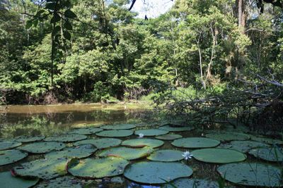
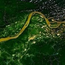
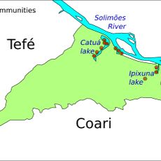
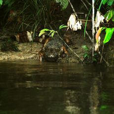
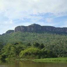
Mamirauá is a protected area of flooded forest and wetlands situated between the Upper Amazon and Japurá River in northern Brazil. It spans parts of six municipalities and is made up of lakes, channels, and islands where local communities make their homes.
Protection of the area began in 1985 when researcher José Márcio Ayres established it as an Ecological Station. It received its current status as a sustainable development reserve in 1996.
The name Mamirauá refers to a lake at the heart of the reserve, with roots in indigenous languages spoken by communities living here. Local residents have built their own ways of moving through the water and forest, shaped by centuries of connection to this land.
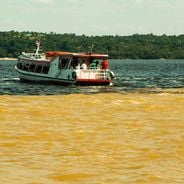
Water routes are the main way to explore the area, as high water levels make travel by water necessary during much of the year. The nearby city of Tefé serves as the main starting point for visits and offers good access to reach the reserve.
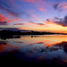
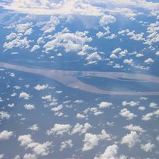
Water levels rise and fall each year by up to 7 to 15 meters, constantly reshaping the landscape. These extreme swings create an ever-shifting network of lakes, streams, and islands that show visitors completely different views of the place depending on the season.
Location: Uarini
Location: Fonte Boa
Location: Maraã
Location: Amazonas
Inception: 1990
Part of: Jaú National Park, Amanã Sustainable Development Reserve and Demonstration Area of Mamirauá Sustainable Development Reserve
Website: http://mamiraua.org.br
GPS coordinates: -2.26000,-65.68000
Latest update: December 6, 2025 17:43
The Amazon River is the world's largest river and flows through the world's largest rainforest. Its waters and those of its many tributaries support an incredible range of life: river dolphins, thousands of fish species, jaguars, anacondas, and countless other animals. The forest itself is a dense...
Pico da Neblina
342.6 km
Amacayacu National Park
520.6 km
Piedra del Cocuy
409.6 km
Pico da Neblina National Park
288.6 km
Pico 31 de Março
343.1 km
Jaú National Park
340.8 km
Serranía La Neblina National Park
359.3 km
Piedra del Cocuy Natural Monument
409.6 km
Santa Rosa Island
523.3 km
Cachoeira do El Dorado
435.4 km
Central Amazon Conservation Complex
408.5 km
Morro dos Seis Lagos Biological Reserve
308.3 km
Central Amazon Ecological Corridor
276.1 km
Serra do Aracá State Park
497.4 km
Médio Juruá Extractive Reserve
431.7 km
Forte de São José de Marabitanas
391.2 km
Tefé National Forest
159.5 km
Cué-cué/Marabitanas Indigenous Territory
370.4 km
Catuá-Ipixuna Extractive Reserve
244.4 km
Uacari Sustainable Development Reserve
447.2 km
Auatí-Paraná Extractive Reserve
112.3 km
Reserva Extrativista do Rio Unini
465.1 kmYaguas River
498.3 km
Cerros Vinilla y Aratitiyope Natural Monument
495 km
Sierra Unturan Natural Monument
447.7 km
Cerros Tapirapecó y Tamacuari Natural Monument
409.4 km
Ilhas Arariá
497.4 km
Cathedral of St. Ann and St. Sebastian, Coari
347.7 kmVisited this place? Tap the stars to rate it and share your experience / photos with the community! Try now! You can cancel it anytime.
Discover hidden gems everywhere you go!
From secret cafés to breathtaking viewpoints, skip the crowded tourist spots and find places that match your style. Our app makes it easy with voice search, smart filtering, route optimization, and insider tips from travelers worldwide. Download now for the complete mobile experience.
A unique approach to discovering new places❞
— Le Figaro
All the places worth exploring❞
— France Info
A tailor-made excursion in just a few clicks❞
— 20 Minutes