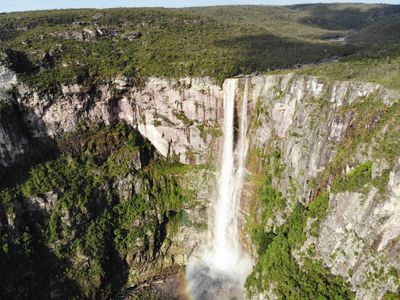
Cachoeira do El Dorado, Remote waterfall in Amazonas, Brazil
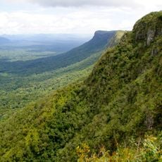
Cachoeira do El Dorado is a waterfall in the heart of the Amazon rainforest that plunges over 350 feet through dense vegetation. The falls originate from the Rio Aracá and cut through a mountainous landscape dominated by tropical forest.
Scientists documented this waterfall during geographical surveys of the Amazon region and added it to Brazil's catalog of significant water features. The discovery by outside researchers eventually brought the site recognition and contributed to understanding its geographical importance.
The waterfall holds meaning for local indigenous communities who weave its presence into their traditional stories and regional knowledge. This connection shows how the landscape functions as a living part of their cultural identity.
Reaching this location requires careful planning and local guidance, since no established trails exist and access involves either aircraft or extensive hiking. Visitors should be prepared for challenging terrain and extreme weather conditions typical of remote rainforest regions.
The waterfall is fed by the Rio Aracá at high elevation and contributes to the complex river system of the Amazon. This geographical feature makes it an important hydrological point within the forest ecosystem.
Address: Barcelos - State of Amazonas, 69700-000, Brazil
GPS coordinates: 0.87393,-63.33964
Latest update: December 12, 2025 17:48
Pico da Neblina
297.2 km
Piedra del Cocuy
389.6 km
Pico da Neblina National Park
296.5 km
Pico 31 de Março
297 km
Jaú National Park
348.3 km
Serranía La Neblina National Park
300.5 km
Piedra del Cocuy Natural Monument
389.6 km
Parima-Tapirapecó National Park
312.8 km
Serra do Tepequém
368.7 km
Fuerte de São Joaquim do Rio Branco
398.6 km
Duida-Marahuaca National Park
386.5 km
Cerro Duida
383.3 km
Central Amazon Conservation Complex
386.6 km
Morro dos Seis Lagos Biological Reserve
378.3 km
Pitinga mine
403 km
Serra da Mocidade National Park
167.9 km
Serra do Aracá State Park
77.1 km
Viruá National Park
250.2 km
Forte de São José de Marabitanas
388.4 km
Cué-cué/Marabitanas Indigenous Territory
394.6 km
Reserva Extrativista do Rio Unini
346.3 km
União Operária Beneficente
367.9 km
Cerros Vinilla y Aratitiyope Natural Monument
281.6 km
Sierra Unturan Natural Monument
252.4 km
Sierra Marutani Natural Monument
321.2 km
Cerros Tapirapecó y Tamacuari Natural Monument
165.5 km
Cathedral Cristo Redentor in Boa Vista
367.3 km
Cerros Ichúm y Guanacoco Natural Monument
421.8 kmVisited this place? Tap the stars to rate it and share your experience / photos with the community! Try now! You can cancel it anytime.
Discover hidden gems everywhere you go!
From secret cafés to breathtaking viewpoints, skip the crowded tourist spots and find places that match your style. Our app makes it easy with voice search, smart filtering, route optimization, and insider tips from travelers worldwide. Download now for the complete mobile experience.
A unique approach to discovering new places❞
— Le Figaro
All the places worth exploring❞
— France Info
A tailor-made excursion in just a few clicks❞
— 20 Minutes