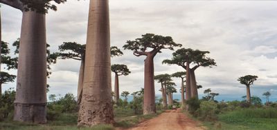
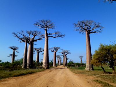
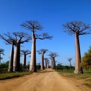
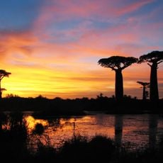
Avenue of the Baobabs, Ancient baobab tree alignment in Menabe, Madagascar.
The Avenue of the Baobabs is a natural alley formed by about 25 massive Grandidier's baobabs lining a dirt road between Morondava and Belon'i Tsiribihina. These giant trees can reach heights over 30 meters (100 feet) and display thick trunks with spreading canopies that shape the landscape of the Menabe region.
These baobabs are remnants of the dense tropical forests that once covered Madagascar before agricultural expansion led to widespread clearing. They have survived over centuries as witnesses to the region's transformation from forest to open landscape.
Local residents call these trees renala, meaning mother of the forest in Malagasy, reflecting their deep connection to the land and survival. Families have relied on them for food, shelter materials, and medicine for generations.
The area is freely accessible without entrance fees, making it an open natural site for visitors. The best times to visit are sunrise and sunset when the light creates beautiful views and temperatures remain comfortable throughout the year.
About 7 kilometers northwest of the main avenue, two baobabs known as Baobab Amoureux have grown intertwined, their trunks naturally wrapping around each other over time. This unusual formation makes them a noteworthy destination for visitors willing to venture beyond the main road.
Location: Menabe
Inception: 2007
Address: RN8, Madagascar
GPS coordinates: -20.25033,44.41927
Latest update: December 6, 2025 16:00
The Earth offers a wide range of geological shapes shaped over millions of years by weather and the movements of the land. In Northern Ireland, thousands of basalt columns stand along the coast, leftover from an ancient eruption. In Arizona, the Colorado River carved out a canyon more than 400 miles long. In Bolivia, a salt flat forms a giant mirror during the rainy season. You can also find white terraces formed by hot springs in Turkey, eroded sandstone arches in the American desert, or the largest coral reef in the world off Australia. Some formations show that volcanic activity still occurs, like in Yellowstone Park. Others are the result of tectonic plate collisions, such as the Himalayas where Mount Everest rises. These places tell the story of Earth's geology and are still changing under the influence of wind, water, and moving continents.
These botanical paths feature beech trees, cherry blossoms, bamboo, maple and oak trees. The branches form natural vaults over roads, paths and railway lines. Some were deliberately planted, others developed over decades. The tunnels provide shade in summer and change their appearance with the seasons.
Madagascar features natural landscapes ranging from the baobab avenues near Morondava to the limestone formations of the Tsingy and coastal areas with coral reefs. The country's national parks protect tropical rainforests inhabited by lemurs, along with geological features including crater lakes and sandstone formations. The highest peaks rise in the northern mountain ranges, while the southern regions are characterized by dry landscapes. Photogenic locations include the Isalo Massif with its eroded sandstone canyons, the Masoala Peninsula with its rainforests along the Indian Ocean, and the island of Nosy Be off the northwest coast. The beaches at Ifaty and Anakao attract visitors for their reefs, while Sainte-Marie Island is known for whale watching between July and September. The Kirindy forests in the west are home to nocturnal lemurs and fossas. Historic sites include the royal hill of Ambohimanga, a UNESCO World Heritage site, and the Rova palace in Antananarivo. The geysers at Ampefy and the crater lake Tritriva showcase the volcanic history of the highlands. The red Tsingy near Sadjoavato formed through erosion of iron-rich sandstone and contrast with the gray limestone Tsingy in the west.
Rova of Antananarivo
358.3 km
Tsingy de Bemaraha Strict Nature Reserve
179.7 km
Isalo National Park
258.3 km
Ranomafana National Park
333.9 km
Iavoloha Palace
354.3 km
Mahamasina Municipal Stadium
357.9 km
Ambohitsorohitra Palace
358.1 km
Andringitra National Park
340.9 km
Lemurs' Park
340.3 km
Aloalo
325 km
Kirindy Forest
29.6 km
Kirindy Mitea National Park
68.7 km
Ankaratra
312.3 km
Botanical and Zoological Garden of Tsimbazaza
357.4 km
Anja Community Reserve
308.5 km
Immaculate Conception Cathedral, Antananarivo
358.4 km
Zoma
358.3 km
Our Lady of La Salette Cathedral, Antsirabé
276.8 km
Lycée Andohalo Antananarivo
358.4 km
Itasy Volcanic Field
280.7 km
Andriamamovoka Falls
331.9 km
Arboretum d'Antsokay
358.7 km
FJKM Rasalama Maritiora Ambohipotsy
357.9 km
Cathédrale du Saint-Nom-de-Jésus
307.3 km
Parc Botanique et Zoologique de Tsimbazaza
357.4 km
Lemurs Park
340.4 km
Andranomandroatra Analavory Geysers
275.7 km
Ifaty Beach
330.7 kmReviews
Visited this place? Tap the stars to rate it and share your experience / photos with the community! Try now! You can cancel it anytime.
Discover hidden gems everywhere you go!
From secret cafés to breathtaking viewpoints, skip the crowded tourist spots and find places that match your style. Our app makes it easy with voice search, smart filtering, route optimization, and insider tips from travelers worldwide. Download now for the complete mobile experience.
A unique approach to discovering new places❞
— Le Figaro
All the places worth exploring❞
— France Info
A tailor-made excursion in just a few clicks❞
— 20 Minutes