Enable Location

We need your location to show you interesting places around you

Discover nearby places

Find interesting locations and hidden gems around you

Precise directions

Get accurate directions and distances to places

Your location is never shared with other users. It's only used when you tap the location button.

Log in to your account

Start exploring — it's free

Trusted by 62,269 travelers worldwide

Continue with Google
Continue with Apple
or

We will send you a code to connect

By continuing, you accept our Terms and Conditions and our Privacy Policy

Check your inbox

We've sent a pincode in your inbox. Please enter the code below.

Seluma, Administrative region in Bengkulu, Indonesia

Seluma is a regency in Bengkulu Province on Sumatra, covering varied terrain from coastal zones to inland areas. The territory includes multiple districts organized around Pasar Tais, which serves as the administrative center where government offices are located.

The region became an independent administrative unit in 2003 when it separated from South Bengkulu. This establishment marked a significant change in how the province's local government was organized.

The Serawai people form the backbone of the community here, maintaining their own language and way of life. You can see this local identity reflected in daily routines and how people interact with their surroundings.

When exploring, know that the region consists of several districts accessible through the main center at Pasar Tais. Check locally about road conditions and accessibility, especially if you plan to visit remote villages or coastal areas.

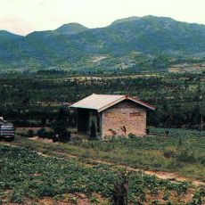
The area brings together coastal landscapes and inland territories at varying elevations, creating geographical diversity within a compact space. This mix of different landscape types shapes how each district looks and functions.

The community of curious travelers

AroundUs brings together thousands of curated places, local tips, and hidden gems, enriched daily by 60,000 contributors worldwide.

Start exploring
Location
Capital city
Pasar Tais
Elevation above the sea
114 m
Shares border with
South Bengkulu, Bengkulu, Central Bengkulu, Kepahiang, Empat Lawang, Lahat
GPS coordinates
-3.96644,102.47429
Latest update
December 7, 2025 20:43
Administrative divisions
« Seluma - Administrative region in Bengkulu, Indonesia » is provided by Around Us (aroundus.com). Images and texts are derived from Wikimedia project under a Creative Commons license. You are allowed to copy, distribute, and modify copies of this page, under the conditions set by the license, as long as this note is clearly visible.

Discover hidden gems everywhere you go!

From secret cafés to breathtaking viewpoints, skip the crowded tourist spots and find places that match your style. Our app makes it easy with voice search, smart filtering, route optimization, and insider tips from travelers worldwide. Download now for the complete mobile experience.

Around Us App Screenshot

A unique approach to discovering new places

Le Figaro

All the places worth exploring

France Info

A tailor-made excursion in just a few clicks

20 Minutes

Around Us
Travel Guide & Maps
Download

Send to your phone

QR Code
1

Open the camera app on your mobile.

2

Point at the QR code with your camera. A notification will appear.

3

Tap the notification to open the link.