Gunung Raja, village in Empat Petulai Dangku District, Muara Enim Regency, South Sumatra, Indonesia
Location: Empat Petulai Dangku
GPS coordinates: -3.39700,104.12300
Latest update: March 7, 2025 08:20
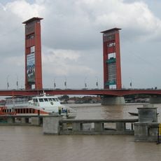
Ampera Bridge
84.2 km
Dempo
130.2 km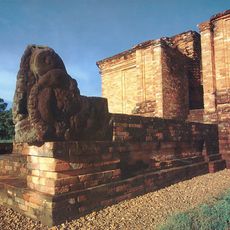
Muaro Jambi Temple Compounds
220.5 km
Lake Ranau
165 km
Fort Marlborough
212.5 km
Bung Karno Seclusion House
211.6 km
Bukit Barisan Selatan National Park
206 km
Muhammad Cheng Hoo Mosque
83.8 km
Great Mosque of Palembang
84.2 km
Prasasti Karang Berahi
236.5 km
Mount Kaba
167.6 km
Sultan Mahmud Badaruddin II Museum
84.1 km
Balaputradeva Museum
83.8 km
Fatmawati's house
211.1 km
Bukit Duabelas National Park
237.7 km
Sembilang National Park
160.8 km
Berbak National Park
225.4 km
Gentala Arasy Tower Museum
209.6 km
Mount Besar
126.2 km
Thomas Parr Monument
212.5 km
Candi Gumpung
219.6 km
Serasan Sekate Stadium
65.2 km
Belirang-Beriti
225.4 km
Ikhsaniyyah Mosque
209.8 km
Akbar At-Taqwa Grand Mosque
211.9 km
Palembang Water Tower
83.7 km
Baitul Mukhlisin Islamic Center Mosque
180.3 km
Maung
104.6 kmReviews
Visited this place? Tap the stars to rate it and share your experience / photos with the community! Try now! You can cancel it anytime.
Discover hidden gems everywhere you go!
From secret cafés to breathtaking viewpoints, skip the crowded tourist spots and find places that match your style. Our app makes it easy with voice search, smart filtering, route optimization, and insider tips from travelers worldwide. Download now for the complete mobile experience.

A unique approach to discovering new places❞
— Le Figaro
All the places worth exploring❞
— France Info
A tailor-made excursion in just a few clicks❞
— 20 Minutes