California State University, Los Angeles

Log in to your account

AroundUs is a community-driven map of interesting places, built by curious explorers like you. It grows with every review, story, and photo you share.
Connect to save your favorite spots, contribute locations, and create personalized routes.
Continue with Google
Continue with Apple
Continue with X
Continue with Facebook
Continue with email
By continuing, you accept our Terms and Conditions and our Privacy Policy
Create an account
Add to collection
Map
Suggest a change
Share

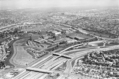
California State University, Los Angeles, Public university in Los Angeles, United States.

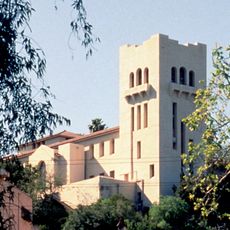
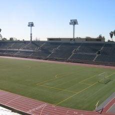
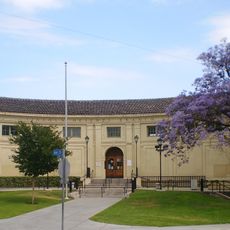
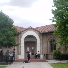
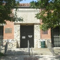
California State University, Los Angeles is a public university in Los Angeles, California, spread across a hillside site. The campus includes lecture halls, libraries, laboratory buildings and open spaces connected by paths and stairs that offer wide views over the city.

The institution was founded shortly after World War Two to meet the needs of a growing number of students in the Los Angeles area. The move to its current location happened about a decade later, when the original site could no longer accommodate the rising enrollment.

The university has served the Hispanic community of Los Angeles for decades, shaping its programs to meet the needs of this population. Students use the facilities every day for lectures, group work and conversation in multiple languages, with Latin American culture present in daily campus life.

Visitors can explore the grounds on foot but should be aware that many areas involve stairs and slopes. Parking is available but often limited on weekdays, so a visit during the weekend tends to be quieter.

A special program allows teenagers to start university studies well before they reach the usual entry age. This option attracts talented young people from across the region and lets them deepen their academic work alongside their school education.

Location: Los Angeles

Inception: 1947

Part of: California State University

Address: 5151 State University Dr, Los Angeles, CA 90032

Website: https://calstatela.edu

GPS coordinates: 34.06667,-118.16778

Latest update: December 12, 2025 21:45

Photos
Around this place
Los Angeles County+USC Medical Center
United States of America

Los Angeles County+USC Medical Center

3.9 km
Arroyo Seco Parkway
United States of America

Arroyo Seco Parkway

4.9 km
Evergreen Cemetery
United States of America

Evergreen Cemetery

4.1 km
Heritage Square Museum
United States of America

Heritage Square Museum

4.4 km
Lummis House
United States of America

Lummis House

4.6 km
Lincoln Park
United States of America

Lincoln Park

3.1 km
Chicken Boy
United States of America

Chicken Boy

5.3 km
Hale House
United States of America

Hale House

4.4 km
Mariachi Plaza
United States of America

Mariachi Plaza

5.2 km
Southwest Museum of the American Indian
United States of America

Southwest Museum of the American Indian

5.1 km
Weingart Stadium
United States of America

Weingart Stadium

3 km
Breed Street Shul
United States of America

Breed Street Shul

4.4 km
Golden Gate Theater
United States of America

Golden Gate Theater

5.3 km
Judson Studios
United States of America

Judson Studios

5.3 km
Pisgah Home Historic District
United States of America

Pisgah Home Historic District

5.2 km
Cawston Ostrich Farm
United States of America

Cawston Ostrich Farm

5.1 km
Ernest E. Debs Regional Park
United States of America

Ernest E. Debs Regional Park

4.1 km
El Mercado de Los Angeles
United States of America

El Mercado de Los Angeles

4.1 km
Arroyo Seco bicycle path
United States of America

Arroyo Seco bicycle path

3.9 km
Santa Fe Arroyo Seco Railroad Bridge
United States of America

Santa Fe Arroyo Seco Railroad Bridge

5.2 km
Boyle Hotel – Cummings Block
United States of America

Boyle Hotel – Cummings Block

5.3 km
Ernest and Florence Bent Halstead House and Grounds
United States of America

Ernest and Florence Bent Halstead House and Grounds

5.1 km
Ziegler Estate
United States of America

Ziegler Estate

4.9 km
Lincoln Heights Branch
United States of America

Lincoln Heights Branch

4.4 km
Robert Louis Stevenson Branch
United States of America

Robert Louis Stevenson Branch

5.1 km
Malabar Branch
United States of America

Malabar Branch

3.3 km
House at 530 S. Marengo Avenue
United States of America

House at 530 S. Marengo Avenue

2.2 km
Mount Pleasant House
United States of America

Mount Pleasant House

4.3 km
Show the full map
Reviews

Visited this place? Tap the stars to rate it and share your experience / photos with the community! Try now! You can cancel it anytime.

« California State University, Los Angeles - Public university in Los Angeles, United States » is provided by Around Us (aroundus.com). Images and texts are derived from Wikimedia project under a Creative Commons license. You are allowed to copy, distribute, and modify copies of this page, under the conditions set by the license, as long as this note is clearly visible.

Discover hidden gems everywhere you go!

From secret cafés to breathtaking viewpoints, skip the crowded tourist spots and find places that match your style. Our app makes it easy with voice search, smart filtering, route optimization, and insider tips from travelers worldwide. Download now for the complete mobile experience.

Around Us App Screenshot

A unique approach to discovering new places

Le Figaro

All the places worth exploring

France Info

A tailor-made excursion in just a few clicks

20 Minutes