Enable Location

We need your location to show you interesting places around you

Discover nearby places

Find interesting locations and hidden gems around you

Precise directions

Get accurate directions and distances to places

Your location is never shared with other users. It's only used when you tap the location button.

Mile Square Regional Park

Log in to your account

Start exploring — it's free

Trusted by 63,009 travelers worldwide

Continue with Google
Continue with Apple
or

We will send you a code to connect

By continuing, you accept our Terms and Conditions and our Privacy Policy

Check your inbox

We've sent a pincode in your inbox. Please enter the code below.

Mile Square Regional Park
Discussion Reviews 1 Photos
7.1k Popularity

Mile Square Regional Park, Regional park in Fountain Valley, California.

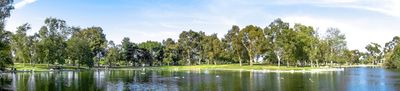
Mile Square Regional Park is a large recreational park in Fountain Valley with diverse sports and nature areas. The grounds feature two lakes, three golf courses, soccer fields, baseball diamonds, and an archery range.

The park originated in 1942 when the U.S. Navy acquired 640 acres of farmland for Naval Air Station Los Alamitos. The site initially served as a training facility for carrier aircraft operations.

The park offers spaces for community gatherings with multiple picnic areas and sports facilities. A section is dedicated to California native plants and demonstrates the natural vegetation of the region.

The grounds are easily accessible by car and feature parking for visitors. The best time to visit is in the morning or late afternoon when the sun is lower and temperatures are more comfortable.

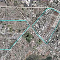
The grounds contain three landing fields arranged in a triangle formation, each originally used for carrier deck training. This unusual layout is a remnant of its time as a naval base and remains visible in how the park is organized today.

The community of curious travelers

AroundUs brings together thousands of curated places, local tips, and hidden gems, enriched daily by 60,000 contributors worldwide.

Start exploring
Location
GPS coordinates
33.72400,-117.94500
Latest update
December 9, 2025 18:40
Around this place
Incredicoaster
United States of America

Incredicoaster

9.2 km
Crystal Cathedral
United States of America

Crystal Cathedral

8.2 km
South Coast Plaza
United States of America

South Coast Plaza

6.3 km
Shepherd's Grove Presbyterian Church
United States of America

Shepherd's Grove Presbyterian Church

8.2 km
Bowers Museum
United States of America

Bowers Museum

8.3 km
Discovery Science Center
United States of America

Discovery Science Center

8.8 km
Bolsa Chica Ecological Reserve
United States of America

Bolsa Chica Ecological Reserve

9.1 km
Pacific Amphitheatre
United States of America

Pacific Amphitheatre

7.4 km
Jessie's Critter Carousel
United States of America

Jessie's Critter Carousel

9.2 km
Santa Ana Stadium
United States of America

Santa Ana Stadium

6.9 km
Crystal Cathedral organ
United States of America

Crystal Cathedral organ

8.2 km
South Coast Repertory
United States of America

South Coast Repertory

6.8 km
Santa Ana Army Air Base
United States of America

Santa Ana Army Air Base

7.1 km
Yost Theater
United States of America

Yost Theater

7.8 km
Downtown Santa Ana Historic Districts
United States of America

Downtown Santa Ana Historic Districts

7.6 km
Diego Sepúlveda Adobe
United States of America

Diego Sepúlveda Adobe

5.7 km
International Surfing Museum
United States of America

International Surfing Museum

8.9 km
Howe-Waffle House and Carriage House
United States of America

Howe-Waffle House and Carriage House

7.9 km
Islamic Center of Orange County
United States of America

Islamic Center of Orange County

3.7 km
Ronald Reagan Federal Building and Courthouse
United States of America

Ronald Reagan Federal Building and Courthouse

7.4 km
Newland House
United States of America

Newland House

6.6 km
Santora Building
United States of America

Santora Building

7.5 km
Odd Fellows Hall
United States of America

Odd Fellows Hall

7.7 km
Main Street Library
United States of America

Main Street Library

8.5 km
Builders Exchange Building
United States of America

Builders Exchange Building

7.6 km
Orange County Museum of Art
United States of America

Orange County Museum of Art

6.9 km
Helme-Worthy Store and Residence
United States of America

Helme-Worthy Store and Residence

9 km
Heritage Museum of Orange County
United States of America

Heritage Museum of Orange County

3.3 km
Show the full map
Reviews
Share your experience

No review yet

Discussions
Start a discussion...

No discussion yet

« Mile Square Regional Park - Regional park in Fountain Valley, California » is provided by Around Us (aroundus.com). Images and texts are derived from Wikimedia project under a Creative Commons license. You are allowed to copy, distribute, and modify copies of this page, under the conditions set by the license, as long as this note is clearly visible.

Discover hidden gems everywhere you go!

From secret cafés to breathtaking viewpoints, skip the crowded tourist spots and find places that match your style. Our app makes it easy with voice search, smart filtering, route optimization, and insider tips from travelers worldwide. Download now for the complete mobile experience.

Around Us App Screenshot

A unique approach to discovering new places

Le Figaro

All the places worth exploring

France Info

A tailor-made excursion in just a few clicks

20 Minutes

Around Us
Travel Guide & Maps
Download

Send to your phone

QR Code
1

Open the camera app on your mobile.

2

Point at the QR code with your camera. A notification will appear.

3

Tap the notification to open the link.