Enable Location

We need your location to show you interesting places around you

Discover nearby places

Find interesting locations and hidden gems around you

Precise directions

Get accurate directions and distances to places

Your location is never shared with other users. It's only used when you tap the location button.

Patagonia Lake State Park

Log in to your account

Start exploring — it's free

Trusted by 61,984 travelers worldwide

Continue with Google
Continue with Apple
or

We will send you a code to connect

By continuing, you accept our Terms and Conditions and our Privacy Policy

Check your inbox

We've sent a pincode in your inbox. Please enter the code below.

Patagonia Lake State Park

Patagonia Lake State Park, State park in Santa Cruz County, United States

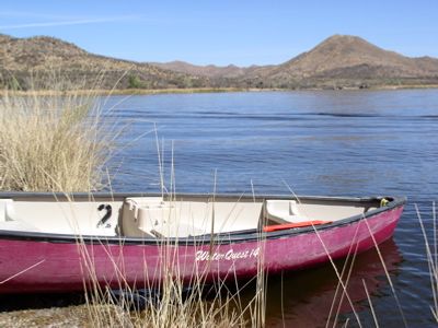
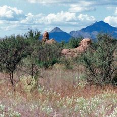
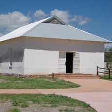
Patagonia Lake State Park is a protected area with a lake surrounded by hills and native plants in southeastern Arizona. The grounds cover about 2,600 acres (1,050 hectares) and include a marina, campground, and trails that wind through and around the shoreline.

The lake and facilities were built in 1967 by the Lake Patagonia Recreation Association and then handed over to Arizona State Parks in 1974. This transfer shifted the site from private stewardship to public management.

The park is a meeting place for people who enjoy outdoor activities and gather for fishing trips or bird observation sessions. Visitors from across the region come here to share these pursuits together.

The park offers boat rentals at the marina, campsites with electrical hookups, and guided bird-watching walks from November through April. The best time to visit is winter through spring when bird populations are most diverse.

A section of Sonoita Creek runs through the park, supporting over 300 bird species, including many rare and migratory types. This water source makes the spot widely known among birdwatchers and nature enthusiasts from around the world.

The community of curious travelers

AroundUs brings together thousands of curated places, local tips, and hidden gems, enriched daily by 60,000 contributors worldwide.

Start exploring
Location
Inception
1974
GPS coordinates
31.49390,-110.85400
Latest update
December 8, 2025 20:02
Around this place
Tumacácori National Historical Park
United States of America

Tumacácori National Historical Park

20.4 km
Mount Wrightson
United States of America

Mount Wrightson

22.5 km
VERITAS
United States of America

VERITAS

22.2 km
MMT Observatory
United States of America

MMT Observatory

21.8 km
Fred Lawrence Whipple Observatory
United States of America

Fred Lawrence Whipple Observatory

21 km
Tumacácori Mission
United States of America

Tumacácori Mission

20.4 km
Tubac Presidio State Historic Park
United States of America

Tubac Presidio State Historic Park

22.5 km
Mount Hopkins
United States of America

Mount Hopkins

21.9 km
Guevavi Mission
United States of America

Guevavi Mission

10.4 km
Nogales-Morley Gate Port of Entry
United States of America

Nogales-Morley Gate Port of Entry

19.8 km
Pete Kitchen Ranch
United States of America

Pete Kitchen Ranch

14 km
Calabazas Mission
United States of America

Calabazas Mission

11 km
Infrared Optical Telescope Array
United States of America

Infrared Optical Telescope Array

22.2 km
Little Red Schoolhouse
United States of America

Little Red Schoolhouse

11.9 km
Cady Hall
United States of America

Cady Hall

10.7 km
James Finley House
United States of America

James Finley House

14.4 km
United States Post Office and Immigration Station–Nogales Main
United States of America

United States Post Office and Immigration Station–Nogales Main

19.1 km
Santa Cruz County Courthouse
United States of America

Santa Cruz County Courthouse

19.3 km
Sen. James A. Harrison House
United States of America

Sen. James A. Harrison House

19 km
US Custom House
United States of America

US Custom House

19.8 km
W.G. Bowman House
United States of America

W.G. Bowman House

18.6 km
George Dunbar House
United States of America

George Dunbar House

18.5 km
Tubac Presidio State Historic Park
United States of America

Tubac Presidio State Historic Park

22.5 km
Frank F. Cranz House
United States of America

Frank F. Cranz House

19.1 km
Tumacácori Museum
United States of America

Tumacácori Museum

20.4 km
Prima Alta History Museum
United States of America

Prima Alta History Museum

19.5 km
Otero Hall
United States of America

Otero Hall

22.5 km
Church of the Immaculate Conception in Nogales
Mexico

Church of the Immaculate Conception in Nogales

20.1 km
Show the full map
« Patagonia Lake State Park - State park in Santa Cruz County, United States » is provided by Around Us (aroundus.com). Images and texts are derived from Wikimedia project under a Creative Commons license. You are allowed to copy, distribute, and modify copies of this page, under the conditions set by the license, as long as this note is clearly visible.

Discover hidden gems everywhere you go!

From secret cafés to breathtaking viewpoints, skip the crowded tourist spots and find places that match your style. Our app makes it easy with voice search, smart filtering, route optimization, and insider tips from travelers worldwide. Download now for the complete mobile experience.

Around Us App Screenshot

A unique approach to discovering new places

Le Figaro

All the places worth exploring

France Info

A tailor-made excursion in just a few clicks

20 Minutes

Around Us
Travel Guide & Maps
Download

Send to your phone

QR Code
1

Open the camera app on your mobile.

2

Point at the QR code with your camera. A notification will appear.

3

Tap the notification to open the link.