Mount Wrightson

Log in to your account

AroundUs is a community-driven map of interesting places, built by curious explorers like you. It grows with every review, story, and photo you share.
Connect to save your favorite spots, contribute locations, and create personalized routes.
Continue with Google
Continue with Apple
Continue with X
Continue with Facebook
Continue with email
By continuing, you accept our Terms and Conditions and our Privacy Policy
Create an account
Add to collection
Map
Suggest a change
Share

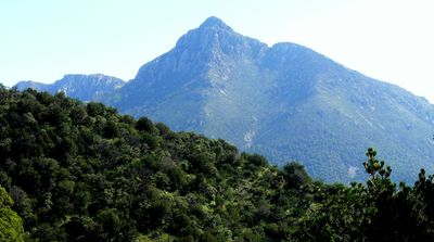
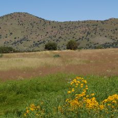
Mount Wrightson, Mountain peak in Santa Cruz County, United States.

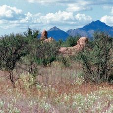
Mount Wrightson is the highest peak in the Santa Rita Mountains, standing at 2,881 meters and forming a distinctive pyramid shape. The summit is visible from communities across southeastern Arizona and across the border into Sonora, Mexico.

The peak was named after William Wrightson, a mining entrepreneur who died during the Battle of Fort Buchanan in 1865. This name reflects the era of early European settlement and the conflicts that marked that period in Arizona.

The mountain held spiritual importance for Apache groups who lived in the surrounding region before European settlement. This indigenous connection remains visible in local place names and the way the land is spoken about by people living nearby.

Two main hiking routes lead to the summit: the Old Baldy Trail and the Super Trail, which meet at Josephine Saddle. The Old Baldy Trail is the shorter option, while the Super Trail takes longer and allows hikers to approach from different starting points.

The summit is known for seasonal gatherings of ladybugs that appear after the first snow melts in November. This natural phenomenon creates a surprising encounter that many hikers do not expect when reaching the top.

Location: Santa Cruz County

Elevation above the sea: 2,881 m

GPS coordinates: 31.69615,-110.84809

Latest update: December 10, 2025 15:55

Photos
Around this place
Titan Missile Museum
United States of America

Titan Missile Museum

27.1 km
Madera Canyon
United States of America

Madera Canyon

10.2 km
Empire Ranch
United States of America

Empire Ranch

21.9 km
Tumacácori National Historical Park
United States of America

Tumacácori National Historical Park

23.9 km
VERITAS
United States of America

VERITAS

10.1 km
MMT Observatory
United States of America

MMT Observatory

3.6 km
Patagonia Lake State Park
United States of America

Patagonia Lake State Park

22.5 km
Fred Lawrence Whipple Observatory
United States of America

Fred Lawrence Whipple Observatory

3.3 km
Fort Buchanan
United States of America

Fort Buchanan

14 km
Tumacácori Mission
United States of America

Tumacácori Mission

23.8 km
Tubac Presidio State Historic Park
United States of America

Tubac Presidio State Historic Park

21 km
Mount Hopkins
United States of America

Mount Hopkins

3.6 km
Las Cienegas National Conservation Area
United States of America

Las Cienegas National Conservation Area

25 km
Guevavi Mission
United States of America

Guevavi Mission

32.3 km
Tucson ring meteorite
United States of America

Tucson ring meteorite

20.5 km
Tubac Presidio
United States of America

Tubac Presidio

21 km
Pete Kitchen Ranch
United States of America

Pete Kitchen Ranch

34.2 km
Calabazas Mission
United States of America

Calabazas Mission

29.1 km
Infrared Optical Telescope Array
United States of America

Infrared Optical Telescope Array

3.5 km
The Little Outfit Schoolhouse
United States of America

The Little Outfit Schoolhouse

34.3 km
Canelo Hills Cienega Reserve
United States of America

Canelo Hills Cienega Reserve

34 km
James Finley House
United States of America

James Finley House

29.1 km
Old Tubac Schoolhouse
United States of America

Old Tubac Schoolhouse

21 km
San Ignacio Golf Club
United States of America

San Ignacio Golf Club

20.5 km
Tubac Presidio State Historic Park
United States of America

Tubac Presidio State Historic Park

21.1 km
Tumacácori Museum
United States of America

Tumacácori Museum

24 km
Otero Hall
United States of America

Otero Hall

21 km
Rojas House
United States of America

Rojas House

21 km
Show the full map
Reviews

Visited this place? Tap the stars to rate it and share your experience / photos with the community! Try now! You can cancel it anytime.

« Mount Wrightson - Mountain peak in Santa Cruz County, United States » is provided by Around Us (aroundus.com). Images and texts are derived from Wikimedia project under a Creative Commons license. You are allowed to copy, distribute, and modify copies of this page, under the conditions set by the license, as long as this note is clearly visible.

Discover hidden gems everywhere you go!

From secret cafés to breathtaking viewpoints, skip the crowded tourist spots and find places that match your style. Our app makes it easy with voice search, smart filtering, route optimization, and insider tips from travelers worldwide. Download now for the complete mobile experience.

Around Us App Screenshot

A unique approach to discovering new places

Le Figaro

All the places worth exploring

France Info

A tailor-made excursion in just a few clicks

20 Minutes