Log in to your account

AroundUs is a community-driven map of interesting places, built by curious explorers like you. It grows with every review, story, and photo you share.
Connect to save your favorite spots, contribute locations, and create personalized routes.
Continue with Google
Continue with Apple
Continue with X
Continue with Facebook
Continue with email
By continuing, you accept our Terms and Conditions and our Privacy Policy
Create an account
Add to collection
Map
Suggest a change
Share

Bear Wallow Wilderness, Protected wilderness area in Apache-Sitgreaves National Forest, Arizona.

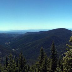
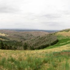
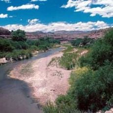
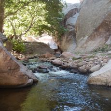
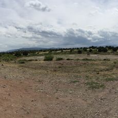
Bear Wallow Wilderness is a protected wild area in Apache-Sitgreaves National Forest in eastern Arizona. The forest contains dense Ponderosa pine stands with streams running year-round across elevations ranging from roughly 6,700 to 8,900 feet.

The area gained official wilderness protection in 1980. A massive wildfire ignited here in 2011, becoming the largest fire ever recorded in Arizona.

The San Carlos Apache Indian Reservation lies nearby, and the tribes maintain deep roots to this territory through traditional resource use. Many local families have walked these lands for countless generations.

Five maintained trails totaling over 18 miles provide access throughout the area. Routes range in difficulty, so visitors should prepare for elevation changes and variable weather conditions.

The name comes from natural depressions created by black bears rolling in soil throughout the canyon system. These marks remain visible today and hint at how long bears have inhabited the area.

Location: Arizona

GPS coordinates: 33.60230,-109.44900

Latest update: December 14, 2025 14:26

Photos
Around this place
Morenci Mine
United States of America

Morenci Mine

57.5 km
Mount Baldy
United States of America

Mount Baldy

35.4 km
Mogollon
United States of America

Mogollon

65 km
Round Valley Ensphere
United States of America

Round Valley Ensphere

59.6 km
Kinishba Ruins
United States of America

Kinishba Ruins

60.8 km
Escudilla Mountain
United States of America

Escudilla Mountain

49.5 km
Lyman Reservoir
United States of America

Lyman Reservoir

84.5 km
Apache National Forest
United States of America

Apache National Forest

33.9 km
Casa Malpaís
United States of America

Casa Malpaís

62.5 km
Gila Box Riparian National Conservation Area
United States of America

Gila Box Riparian National Conservation Area

75.8 km
Alpine Elementary School
United States of America

Alpine Elementary School

37.8 km
Cedar Canyon Bridge
United States of America

Cedar Canyon Bridge

86.7 km
Park Avenue Bridge
United States of America

Park Avenue Bridge

62.4 km
Lake Mountain Lookout Complex
United States of America

Lake Mountain Lookout Complex

68.6 km
Butterfly Lodge
United States of America

Butterfly Lodge

46.4 km
Whitewater Creek
United States of America

Whitewater Creek

61.3 km
Eagar Townsite Historic District
United States of America

Eagar Townsite Historic District

58.1 km
Corduroy Creek Bridge
United States of America

Corduroy Creek Bridge

85.9 km
White Mountain Family Fun Park
United States of America

White Mountain Family Fun Park

81.9 km
Clifton Townsite Historic District
United States of America

Clifton Townsite Historic District

62.5 km
Eagar School
United States of America

Eagar School

58.1 km
Los Burros Ranger Station
United States of America

Los Burros Ranger Station

66.7 km
PS Knoll Lookout Complex
United States of America

PS Knoll Lookout Complex

17.6 km
Gila River Bridge
United States of America

Gila River Bridge

72.1 km
Mogollon Baldy Lookout Cabin
United States of America

Mogollon Baldy Lookout Cabin

87.5 km
Black Gap Bridge
United States of America

Black Gap Bridge

74 km
Cosmic Campground
United States of America

Cosmic Campground

50.7 km
Chase Creek Railroad Bridge
United States of America

Chase Creek Railroad Bridge

62.2 km
Show the full map
Reviews

Visited this place? Tap the stars to rate it and share your experience / photos with the community! Try now! You can cancel it anytime.

« Bear Wallow Wilderness - Protected wilderness area in Apache-Sitgreaves National Forest, Arizona » is provided by Around Us (aroundus.com). Images and texts are derived from Wikimedia project under a Creative Commons license. You are allowed to copy, distribute, and modify copies of this page, under the conditions set by the license, as long as this note is clearly visible.

Discover hidden gems everywhere you go!

From secret cafés to breathtaking viewpoints, skip the crowded tourist spots and find places that match your style. Our app makes it easy with voice search, smart filtering, route optimization, and insider tips from travelers worldwide. Download now for the complete mobile experience.

Around Us App Screenshot

A unique approach to discovering new places

Le Figaro

All the places worth exploring

France Info

A tailor-made excursion in just a few clicks

20 Minutes