Enable Location

We need your location to show you interesting places around you

Discover nearby places

Find interesting locations and hidden gems around you

Precise directions

Get accurate directions and distances to places

Your location is never shared with other users. It's only used when you tap the location button.

Michoacán-Guanajuato volcanic field

Log in to your account

Start exploring — it's free

Trusted by 63,328 travelers worldwide

Continue with Google
Continue with Apple
or

We will send you a code to connect

By continuing, you accept our Terms and Conditions and our Privacy Policy

Check your inbox

We've sent a pincode in your inbox. Please enter the code below.

Michoacán-Guanajuato volcanic field
Discussion Reviews 1 Photos
7.5k Popularity

Michoacán-Guanajuato volcanic field, Volcanic field in central Mexico

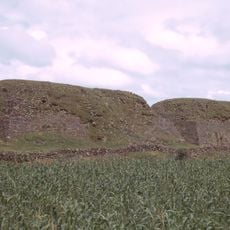
The Michoacán-Guanajuato volcanic field covers a broad area of central Mexico's highlands and contains thousands of volcanic vents of different types. Cinder cones, shield volcanoes, and circular crater lakes show the region's complex geological development.

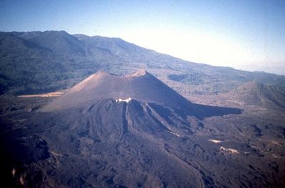
The field developed over vast geological timescales through repeated volcanic activity and became world-famous in 1943 when Paricutín volcano emerged suddenly from a cornfield. This event allowed scientists to witness and study the birth of a volcano in real time.

Local communities grow corn, beans, and other crops in the nutrient-rich soil created by volcanic activity. Farming practices here reflect generations of knowledge about working with volcanic terrain.

Visitors should stay on established trails and marked routes because the terrain is rough and uneven throughout the area. Local guides know the safest paths and current conditions, making exploration both safer and more informative.

The Siete Luminarias formation in Valle de Santiago displays seven circular crater lakes side by side, each created by explosive volcanic blasts. This unusual cluster provides a rare view of multiple crater features in close proximity.

The community of curious travelers

AroundUs brings together thousands of curated places, local tips, and hidden gems, enriched daily by 60,000 contributors worldwide.

Start exploring
Location
Location
Elevation above the sea
3,860 m
GPS coordinates
19.85000,-101.75000
Latest update
December 10, 2025 15:47
Reviews
Share your experience

No review yet

Discussions
Start a discussion...

No discussion yet

« Michoacán-Guanajuato volcanic field - Volcanic field in central Mexico » is provided by Around Us (aroundus.com). Images and texts are derived from Wikimedia project under a Creative Commons license. You are allowed to copy, distribute, and modify copies of this page, under the conditions set by the license, as long as this note is clearly visible.

Discover hidden gems everywhere you go!

From secret cafés to breathtaking viewpoints, skip the crowded tourist spots and find places that match your style. Our app makes it easy with voice search, smart filtering, route optimization, and insider tips from travelers worldwide. Download now for the complete mobile experience.

Around Us App Screenshot

A unique approach to discovering new places

Le Figaro

All the places worth exploring

France Info

A tailor-made excursion in just a few clicks

20 Minutes

Around Us
Travel Guide & Maps
Download

Send to your phone

QR Code
1

Open the camera app on your mobile.

2

Point at the QR code with your camera. A notification will appear.

3

Tap the notification to open the link.