Enable Location

We need your location to show you interesting places around you

Discover nearby places

Find interesting locations and hidden gems around you

Precise directions

Get accurate directions and distances to places

Your location is never shared with other users. It's only used when you tap the location button.

Acueducto de los Remedios

Log in to your account

Start exploring — it's free

Trusted by 61,840 travelers worldwide

Continue with Google
Continue with Apple
or

We will send you a code to connect

By continuing, you accept our Terms and Conditions and our Privacy Policy

Check your inbox

We've sent a pincode in your inbox. Please enter the code below.

Acueducto de los Remedios

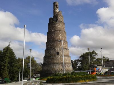
Acueducto de los Remedios, Colonial aqueduct monument in Naucalpan de Juárez, Mexico.

Description

Acueducto de los Remedios is a stone structure featuring approximately 50 semicircular arches spanning 500 meters with heights reaching 16 meters. The construction now serves as a pedestrian crossing between neighborhoods while framing views of surrounding forested areas.

History

Construction began in 1616 under Viceroy Diego Fernández de Córdoba to carry water from San Francisco Chimalpa to the Los Remedios sanctuary. The project represented a major colonial-era infrastructure effort to supply the region.

Culture

Local residents call the two round towers 'Los Caracoles', named for their spiral-like appearance and former role in controlling water pressure. This nickname reflects how the community has connected with the structure's engineering purpose over centuries.

Practical

The site is easy to explore on foot with straightforward paths across the stone arches. Morning or late afternoon visits work best, as the light enhances the structure and temperatures are more comfortable.

Did you know?

Despite its elaborate engineering design and significant construction efforts, the aqueduct never successfully transported water to its intended destination. This incomplete mission makes it a fascinating example of ambitious planning that reality could not match.

GPS coordinates
19.46772,-99.25577
Latest update
December 8, 2025 19:54

AroundUs brings together thousands of curated places, local tips, and hidden gems, enriched daily by 60,000 contributors worldwide. Discover all places nearby (Naucalpan de Juárez Municipality).

« Acueducto de los Remedios - Colonial aqueduct monument in Naucalpan de Juárez, Mexico » is provided by Around Us (aroundus.com). Images and texts are derived from Wikimedia project under a Creative Commons license. You are allowed to copy, distribute, and modify copies of this page, under the conditions set by the license, as long as this note is clearly visible.

Discover hidden gems everywhere you go!

From secret cafés to breathtaking viewpoints, skip the crowded tourist spots and find places that match your style. Our app makes it easy with voice search, smart filtering, route optimization, and insider tips from travelers worldwide. Download now for the complete mobile experience.

Around Us App Screenshot

A unique approach to discovering new places

Le Figaro

All the places worth exploring

France Info

A tailor-made excursion in just a few clicks

20 Minutes

Around Us
Travel Guide & Maps
Download

Send to your phone

QR Code
1

Open the camera app on your mobile.

2

Point at the QR code with your camera. A notification will appear.

3

Tap the notification to open the link.