Enable Location

We need your location to show you interesting places around you

Discover nearby places

Find interesting locations and hidden gems around you

Precise directions

Get accurate directions and distances to places

Your location is never shared with other users. It's only used when you tap the location button.

Los Remedios National Park

Log in to your account

Join the adventure

Create your free account and start exploring

Save your favorite places
Create custom travel routes
Rate and review places
Access the full interactive map
Continue with Google
Continue with Apple
Continue with email
By continuing, you accept our Terms and Conditions and our Privacy Policy

We will send you a code to connect

We've sent a pincode in your inbox. Please enter the code below.

Los Remedios National Park

Los Remedios National Park, National park in Naucalpan de Juárez, Mexico

Description

Los Remedios is a national park near Mexico City with hiking trails that wind through deciduous forests and scrubland where visitors encounter archaeological remains. The grounds include several walking areas and wildlife observation spots, along with a historic stone structure that crosses the park landscape.

History

The site served as an Aztec observatory before Hernán Cortés used it as a rest stop after his retreat from Tenochtitlan. The presence of archaeological remains alongside colonial structures shows how the location experienced different periods of settlement and use.

Culture

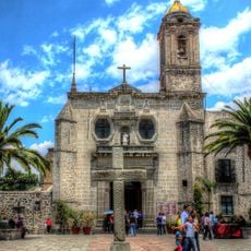
The sanctuary dedicated to the Virgin of Los Remedios draws visitors who come to pray and spend time in this forest setting. The site blends religious devotion with nature, creating a space where both daily worship and peaceful walks happen together.

Practical

The park has several marked trails for different ability levels, with areas where visitors can walk safely without getting lost. Comfortable shoes are recommended, as the paths involve changing elevation.

Did you know?

A striking arched stone structure crosses the park and dates to the colonial era, yet remains well preserved today. Visitors can walk directly across this remnant of colonial engineering while exploring the grounds.

i
Inception
April 15, 1938
i
GPS coordinates
19.47520,-99.25390
i
Latest update
December 9, 2025 18:49

AroundUs brings together thousands of curated places, local tips, and hidden gems, enriched daily by 60,000 contributors worldwide. Discover all places nearby (Naucalpan de Juárez Municipality).

Reviews

Visited this place? Tap the stars to rate it and share your experience / photos with the community! Try now! You can cancel it anytime.

« Los Remedios National Park - National park in Naucalpan de Juárez, Mexico » is provided by Around Us (aroundus.com). Images and texts are derived from Wikimedia project under a Creative Commons license. You are allowed to copy, distribute, and modify copies of this page, under the conditions set by the license, as long as this note is clearly visible.

Discover hidden gems everywhere you go!

From secret cafés to breathtaking viewpoints, skip the crowded tourist spots and find places that match your style. Our app makes it easy with voice search, smart filtering, route optimization, and insider tips from travelers worldwide. Download now for the complete mobile experience.

Around Us App Screenshot

A unique approach to discovering new places

Le Figaro

All the places worth exploring

France Info

A tailor-made excursion in just a few clicks

20 Minutes