Kinney County

Log in to your account

AroundUs is a community-driven map of interesting places, built by curious explorers like you. It grows with every review, story, and photo you share.
Connect to save your favorite spots, contribute locations, and create personalized routes.
By continuing, you accept our Terms and Conditions and our Privacy Policy
Add to collection
Map
Suggest a change
Share

Kinney County, Administrative division in southwestern Texas, United States

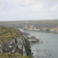
Kinney County is an administrative division in southwestern Texas characterized by flat plains and rolling hills near the Rio Grande border. The county spans a wide area with this distinctive landscape typical of the border region.

The Texas legislature established the county in 1850, naming it after early settler Henry Lawrence Kinney. This creation reflected the territorial expansion and administrative organization of Texas at that time.

Native American tribes, including the Apache and Coahuiltecan peoples, were the original inhabitants of the river valleys here. Their presence shaped the land long before any other settlements developed.

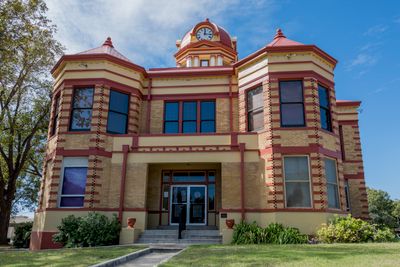
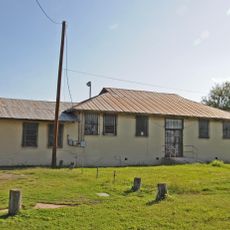
Brackettville serves as the county seat with government offices and is the main hub for administrative services. Plan ahead when visiting public buildings, as security procedures may apply at certain locations.

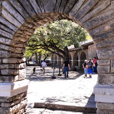
Fort Clark, a former military post on Las Moras Creek, was home to Black Seminole scouts who guarded the southern frontier for many decades. This lesser-known chapter shaped the region's development in important ways.

GPS coordinates: 29.32642,-100.41657

Latest update: December 7, 2025 20:40

Around this place
Show the full map
Garner State Park
United States of America

Garner State Park

71.6 km
Amistad Reservoir
Mexico

Amistad Reservoir

63.7 km
Fort Clark
United States of America

Fort Clark

2.3 km
Sleeping Spring Draw
United States of America

Sleeping Spring Draw

29.7 km
Seminole Canyon State Park and Historic Site
United States of America

Seminole Canyon State Park and Historic Site

95.9 km
Amistad National Recreation Area
United States of America

Amistad National Recreation Area

62.7 km
Fort Inge
United States of America

Fort Inge

65.3 km
Fort Duncan
United States of America

Fort Duncan

70.1 km
Eagle Pass – Piedras Negras International Bridge
United States of America

Eagle Pass – Piedras Negras International Bridge

69.7 km
John Nance Garner House
United States of America

John Nance Garner House

61.9 km
Lake Amistad Dam International Crossing
United States of America

Lake Amistad Dam International Crossing

63.7 km
Camino Real International Bridge
United States of America

Camino Real International Bridge

70.6 km
Whitehead Memorial Museum
United States of America

Whitehead Memorial Museum

46.8 km
Grand Opera House
United States of America

Grand Opera House

62.5 km
Rio San Rodrigo
Mexico

Rio San Rodrigo

51.6 km
Martyrs of Christ the King Cathedral, Piedras Negras
Mexico

Martyrs of Christ the King Cathedral, Piedras Negras

72.6 km
Edwards County Courthouse and Jail
United States of America

Edwards County Courthouse and Jail

79.4 km
Pecos River Bridge
United States of America

Pecos River Bridge

100.1 km
Fate Bell Shelter
United States of America

Fate Bell Shelter

96.2 km
State Highway 3 Bridge at the Nueces River
United States of America

State Highway 3 Bridge at the Nueces River

51.7 km
Lower Pecos Canyonlands Archeological District
United States of America

Lower Pecos Canyonlands Archeological District

96.2 km
Uvalde Downtown Historic District
United States of America

Uvalde Downtown Historic District

62.5 km
Seminole Canyon District
United States of America

Seminole Canyon District

96.2 km
St. Philip's Episcopal Church
United States of America

St. Philip's Episcopal Church

62.3 km
Aztec Theatre
United States of America

Aztec Theatre

69.3 km
Pecos River Boat Dock
United States of America

Pecos River Boat Dock

100.6 km
Combination Building
United States of America

Combination Building

72.1 km
Nicolas Street School
United States of America

Nicolas Street School

62.1 km
Show the full map

Reviews

Visited this place? Tap the stars to rate it and share your experience / photos with the community! Try now! You can cancel it anytime.

« Kinney County - Administrative division in southwestern Texas, United States » is provided by Around Us (aroundus.com). Images and texts are derived from Wikimedia project under a Creative Commons license. You are allowed to copy, distribute, and modify copies of this page, under the conditions set by the license, as long as this note is clearly visible.

Discover hidden gems everywhere you go!

From secret cafés to breathtaking viewpoints, skip the crowded tourist spots and find places that match your style. Our app makes it easy with voice search, smart filtering, route optimization, and insider tips from travelers worldwide. Download now for the complete mobile experience.

Around Us App Screenshot

A unique approach to discovering new places

Le Figaro

All the places worth exploring

France Info

A tailor-made excursion in just a few clicks

20 Minutes