Enable Location

We need your location to show you interesting places around you

Discover nearby places

Find interesting locations and hidden gems around you

Precise directions

Get accurate directions and distances to places

Your location is never shared with other users. It's only used when you tap the location button.

Fort Pike Bridge

Log in to your account

Start exploring — it's free

Trusted by 63,212 travelers worldwide

Continue with Google
Continue with Apple
or

We will send you a code to connect

By continuing, you accept our Terms and Conditions and our Privacy Policy

Check your inbox

We've sent a pincode in your inbox. Please enter the code below.

Fort Pike Bridge
Discussion Reviews 1 Photos
3.8k Popularity

Fort Pike Bridge, Road bridge between Orleans Parish and St. Tammany Parish, United States

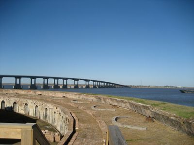
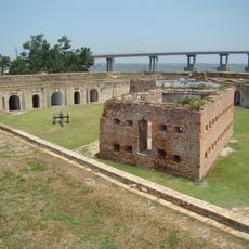
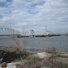
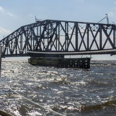
Fort Pike Bridge is a road bridge that crosses the Rigolets strait and connects New Orleans with Slidell via U.S. Route 90. The structure uses box girder construction and allows ships to pass underneath with a clearance of about 72 feet (22 meters).

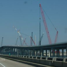
Construction of the bridge began in October 2004 but faced delays from Hurricane Katrina before its completion in January 2008. It replaced an earlier swing bridge, marking a significant advancement in how the region moved traffic across the strait.

The bridge provides access to Fort Pike State Historic Site, which presents exhibits about military operations and coastal defense systems point.

The bridge has two lanes and shoulder areas that provide space for vehicles to pull over if needed. Weather conditions can change quickly when crossing water, so drivers should adjust their speed accordingly.

The bridge replaced an older swing bridge that required stopping traffic whenever a ship needed to pass through. This shift in design shows how transportation priorities changed as automobile traffic grew in the region.

The community of curious travelers

AroundUs brings together thousands of curated places, local tips, and hidden gems, enriched daily by 60,000 contributors worldwide.

Start exploring
Location
Inception
2008
Official opening
January 15, 2008
GPS coordinates
30.17181,-89.73343
Latest update
December 11, 2025 18:06
Around this place
Six Flags New Orleans
United States of America

Six Flags New Orleans

23.6 km
Interstate 10
United States of America

Interstate 10

8.9 km
I-10 Twin Span Bridge
United States of America

I-10 Twin Span Bridge

8.9 km
John C. Stennis Space Center
United States of America

John C. Stennis Space Center

24.8 km
Fort Macomb
United States of America

Fort Macomb

13.8 km
IHNC Lake Borgne Surge Barrier
United States of America

IHNC Lake Borgne Surge Barrier

24.6 km
Fort Pike
United States of America

Fort Pike

719 m
The Jester
United States of America

The Jester

23.5 km
Mega Zeph
United States of America

Mega Zeph

23.7 km
Maestri Bridge
United States of America

Maestri Bridge

10.7 km
Zydeco Scream
United States of America

Zydeco Scream

23.7 km
Muskrat Scrambler
United States of America

Muskrat Scrambler

23.6 km
Chef Menteur Bridge
United States of America

Chef Menteur Bridge

13.4 km
Francois Cousin House
United States of America

Francois Cousin House

14.8 km
CSX Rigolets Pass Bridge
United States of America

CSX Rigolets Pass Bridge

10 km
National Weather Service New Orleans/Baton Rouge, Louisiana
United States of America

National Weather Service New Orleans/Baton Rouge, Louisiana

20.4 km
Bayou Sauvage National Wildlife Refuge
United States of America

Bayou Sauvage National Wildlife Refuge

15.2 km
Camp Salmen House
United States of America

Camp Salmen House

15.9 km
West Rigolets Light
United States of America

West Rigolets Light

1 km
CSX Chef Menteur Pass Bridge
United States of America

CSX Chef Menteur Pass Bridge

13.6 km
East Rigolets Light
United States of America

East Rigolets Light

8.2 km
Francois Cousin House
United States of America

Francois Cousin House

24.8 km
Versailles Arms
United States of America

Versailles Arms

22.4 km
Arcade Theatre
United States of America

Arcade Theatre

12.3 km
Thánh đường Các thánh tử đạo Việt Nam
United States of America

Thánh đường Các thánh tử đạo Việt Nam

22.7 km
Rocket Propulsion Test Complex
United States of America

Rocket Propulsion Test Complex

25.6 km
INFINITY Science Center
United States of America

INFINITY Science Center

19.9 km
Rigolets Bridge
United States of America

Rigolets Bridge

0 m
Show the full map
Reviews
Share your experience

No review yet

Discussions
Start a discussion...

No discussion yet

« Fort Pike Bridge - Road bridge between Orleans Parish and St. Tammany Parish, United States » is provided by Around Us (aroundus.com). Images and texts are derived from Wikimedia project under a Creative Commons license. You are allowed to copy, distribute, and modify copies of this page, under the conditions set by the license, as long as this note is clearly visible.

Discover hidden gems everywhere you go!

From secret cafés to breathtaking viewpoints, skip the crowded tourist spots and find places that match your style. Our app makes it easy with voice search, smart filtering, route optimization, and insider tips from travelers worldwide. Download now for the complete mobile experience.

Around Us App Screenshot

A unique approach to discovering new places

Le Figaro

All the places worth exploring

France Info

A tailor-made excursion in just a few clicks

20 Minutes

Around Us
Travel Guide & Maps
Download

Send to your phone

QR Code
1

Open the camera app on your mobile.

2

Point at the QR code with your camera. A notification will appear.

3

Tap the notification to open the link.