Estreito, Municipal center in southern Maranhão, Brazil.
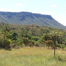
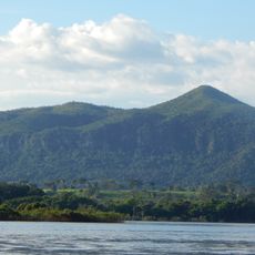
Estreito is a municipality in southern Maranhão, Brazil, located where the Tocantins River runs narrow and crossable, making it a natural meeting point between states. The town grew up around this strategic river location where transportation routes converge.
The settlement began in 1909 when a small village was founded at the narrowest point of the Tocantins River to serve as a crossing point. Over time it became an important link connecting Maranhão with the neighboring state of Tocantins.
The municipality maintains educational programs through its Municipal Education Department, focusing on expanding access to education for local inhabitants.
Two bridges cross the Tocantins River and connect the municipality to the neighboring state: a road bridge and a railway bridge on the North-South Railway. These crossing points make movement between the two regions straightforward for travelers.
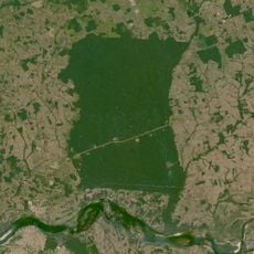
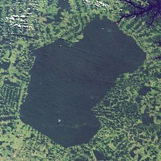
A large hydroelectric power plant completed in 2012 harnesses the dammed river to generate electricity for the region. The reservoir created by the dam is surprisingly vast and transforms the river landscape into something quite different from before.
Location: Maranhão
Elevation above the sea: 294 m
Shares border with: São Pedro dos Crentes, Aguiarnópolis, Carolina, Darcinópolis, Palmeiras do Tocantins, Porto Franco, São João do Paraíso
GPS coordinates: -6.56083,-47.45083
Latest update: December 7, 2025 19:27
Jalapão
414.8 km
Chapada das Mesas National Park
59.9 km
Marabá Combined Bridge
227.4 km
Nascentes do Rio Parnaíba National Park
392.4 km
Poço Azul
132.7 km
Pedra Caida
53.8 km
Carajás National Forest
306.3 km
Estádio Municipal Zinho de Oliveira
230.3 km
Museu Histórico do Tocantins
413.7 km
Monumento das Castanheiras Mortas
213.3 km
Terra Indígena Mãe Maria
229.1 km
Lajeado State Park
403.7 km
Gurupi Biological Reserve
321.2 km
Ponte Juscelino Kubitschek de Oliveira
984 m
São Geraldo do Araguaia Environmental Protection Area
116 km
Puente Ferroviario de Estreito MA
1 km
Parakanã Indigenous Territory
358.1 km
Encanto Azul
137 km
Serra dos Martírios/Andorinhas State Park
128.2 km
St. Therese Cathedral, Bacabal
394.1 km
Biblioteca Pública Municipal Orlando Lima Lobo
230.3 km
Cajàzeira River
293.4 km
Fervedouro Bela Vista
413.8 km
Cachoeira da Velha
416.6 km
Serra da Catedral do Jalapão
402.7 km
Catedral Nossa Senhora da Fátima, Imperatriz
114.6 km
Praia do Rio Novo
416.6 km
Cachoeira do Edilson
415.3 kmVisited this place? Tap the stars to rate it and share your experience / photos with the community! Try now! You can cancel it anytime.
Discover hidden gems everywhere you go!
From secret cafés to breathtaking viewpoints, skip the crowded tourist spots and find places that match your style. Our app makes it easy with voice search, smart filtering, route optimization, and insider tips from travelers worldwide. Download now for the complete mobile experience.
A unique approach to discovering new places❞
— Le Figaro
All the places worth exploring❞
— France Info
A tailor-made excursion in just a few clicks❞
— 20 Minutes