Enable Location

We need your location to show you interesting places around you

Discover nearby places

Find interesting locations and hidden gems around you

Precise directions

Get accurate directions and distances to places

Your location is never shared with other users. It's only used when you tap the location button.

Log in to your account

Start exploring — it's free

Trusted by 63,487 travelers worldwide

Continue with Google
Continue with Apple
or

We will send you a code to connect

By continuing, you accept our Terms and Conditions and our Privacy Policy

Check your inbox

We've sent a pincode in your inbox. Please enter the code below.

Mathers Bridge
Discussion Reviews Photo
2.7k Popularity

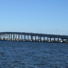
Mathers Bridge, Road bridge in southern Merritt Island, Florida, US

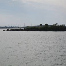
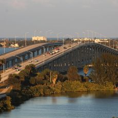
Mathers Bridge is a road bridge made of steel and concrete that crosses the Banana River between Merritt Island and Indian Harbour Beach. The structure includes a rotating center section designed to allow boat traffic to pass through the waterway.

The structure was built in 1927 as a private toll crossing and operated under private ownership initially. In 1944, the Florida State Road Department took over management and converted it into public infrastructure.

The bridge serves as a daily crossing for residents connecting two communities across the river. It remains a functional part of local life, used regularly by people traveling between Merritt Island and the barrier island.

The bridge features a motorized rotating section that opens to let boats pass through the river. Visitors should expect occasional delays when boat traffic needs to cross.

The structure uses a Warren truss swing span design, a rare engineering solution from the early 1900s. This construction method is seldom seen in the region today and demonstrates historical bridge-building techniques.

The community of curious travelers

AroundUs brings together thousands of curated places, local tips, and hidden gems, enriched daily by 60,000 contributors worldwide.

Start exploring
Location
GPS coordinates
28.14917,-80.60611
Latest update
December 12, 2025 14:20
Around this place
Merritt Island Dragon
United States of America

Merritt Island Dragon

804 m
Melbourne Bone Bed
United States of America

Melbourne Bone Bed

5.5 km
Melbourne Causeway
United States of America

Melbourne Causeway

7.4 km
Maxwell C. King Center for the Performing Arts
United States of America

Maxwell C. King Center for the Performing Arts

6.6 km
American Muscle Car Museum
United States of America

American Muscle Car Museum

7.9 km
Green Gables
United States of America

Green Gables

7.1 km
Eau Gallie Causeway
United States of America

Eau Gallie Causeway

2.2 km
Melbourne Beach Pier
United States of America

Melbourne Beach Pier

9.8 km
Henegar Center
United States of America

Henegar Center

7.9 km
Winchester Symphony House
United States of America

Winchester Symphony House

2.9 km
Liberty Bell Memorial Museum
United States of America

Liberty Bell Memorial Museum

7.3 km
Florida Power and Light Company Ice Plant
United States of America

Florida Power and Light Company Ice Plant

7.4 km
Foosaner Art Museum
United States of America

Foosaner Art Museum

2.9 km
Airport Museum
United States of America

Airport Museum

6.4 km
William H. Gleason House
United States of America

William H. Gleason House

2.8 km
Historic Rossetter House Museum
United States of America

Historic Rossetter House Museum

3 km
Eau Gallie Historic District
United States of America

Eau Gallie Historic District

3.2 km
Nannie Lee House
United States of America

Nannie Lee House

7.8 km
James Wadsworth Rossetter House
United States of America

James Wadsworth Rossetter House

3 km
Holy Trinity Episcopal Church
United States of America

Holy Trinity Episcopal Church

7.9 km
Roesch House
United States of America

Roesch House

3 km
Eau Gallie Public Library
United States of America

Eau Gallie Public Library

2.7 km
Original Melbourne Village Hall
United States of America

Original Melbourne Village Hall

9.2 km
Holy Trinity Episcopal Church Parish
United States of America

Holy Trinity Episcopal Church Parish

7.9 km
Paradise Beach
United States of America

Paradise Beach

4.1 km
Ginter Building
United States of America

Ginter Building

2.9 km
Old Eau Gallie Post Office
United States of America

Old Eau Gallie Post Office

2.9 km
Myles Building
United States of America

Myles Building

7.9 km
Show the full map
Reviews
Share your experience

No review yet

Discussions
Start a discussion...

No discussion yet

« Mathers Bridge - Road bridge in southern Merritt Island, Florida, US » is provided by Around Us (aroundus.com). Images and texts are derived from Wikimedia project under a Creative Commons license. You are allowed to copy, distribute, and modify copies of this page, under the conditions set by the license, as long as this note is clearly visible.

Discover hidden gems everywhere you go!

From secret cafés to breathtaking viewpoints, skip the crowded tourist spots and find places that match your style. Our app makes it easy with voice search, smart filtering, route optimization, and insider tips from travelers worldwide. Download now for the complete mobile experience.

Around Us App Screenshot

A unique approach to discovering new places

Le Figaro

All the places worth exploring

France Info

A tailor-made excursion in just a few clicks

20 Minutes

Around Us
Travel Guide & Maps
Download

Send to your phone

QR Code
1

Open the camera app on your mobile.

2

Point at the QR code with your camera. A notification will appear.

3

Tap the notification to open the link.